<< Our Photo Pages >> Ca Knowe (Hawick) - Cairn in Scotland in Scottish Borders
Submitted by Anne T on Sunday, 04 June 2017 Page Views: 2112
Neolithic and Bronze AgeSite Name: Ca Knowe (Hawick) Alternative Name: Auld Ca Knowe; Hero's Grave Cairn; Caa KnoweCountry: Scotland
NOTE: This site is 2.463 km away from the location you searched for.
County: Scottish Borders Type: Cairn
Nearest Town: Hawick
Map Ref: NT4793409075
Latitude: 55.372886N Longitude: 2.823104W
Condition:
| 5 | Perfect |
| 4 | Almost Perfect |
| 3 | Reasonable but with some damage |
| 2 | Ruined but still recognisable as an ancient site |
| 1 | Pretty much destroyed, possibly visible as crop marks |
| 0 | No data. |
| -1 | Completely destroyed |
| 5 | Superb |
| 4 | Good |
| 3 | Ordinary |
| 2 | Not Good |
| 1 | Awful |
| 0 | No data. |
| 5 | Can be driven to, probably with disabled access |
| 4 | Short walk on a footpath |
| 3 | Requiring a bit more of a walk |
| 2 | A long walk |
| 1 | In the middle of nowhere, a nightmare to find |
| 0 | No data. |
| 5 | co-ordinates taken by GPS or official recorded co-ordinates |
| 4 | co-ordinates scaled from a detailed map |
| 3 | co-ordinates scaled from a bad map |
| 2 | co-ordinates of the nearest village |
| 1 | co-ordinates of the nearest town |
| 0 | no data |
Internal Links:
External Links:
I have visited· I would like to visit
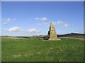
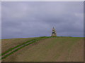
Anne T visited on 3rd Jun 2017 - their rating: Cond: 2 Amb: 4 Access: 4 Ca Knowe Cairn, Hawick (aka Hero's Grave): Simply marked as ‘cairn’ on Trigpointing UK's OS map, we could see this cairn from Lord’s Tree Cairn. There is a proper tarmacked footpath up to the modern standing stone with plaque on it. Closer to, it is much larger than it appears from the mark on the map, and has a proper tarmacked path up to it.
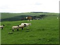
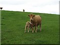
Unfortunately, both on our way to our next site, and our way back to Hawick, the monument was surrounded by a number of very large cows with their calves, so we decided not to risk upsetting them and drove on after having taken some photographs.
 (PID:166428)")
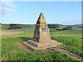
Situated not far from Lord's Tree Cairn, this is simply marked as a cairn on the OS map. Canmore ID 54041 tells us that "a cairn of unrecorded size stood on Auld Ca Knowe, at a height of 710 OD and was demolished for stones in 1811 when a cist containing human bones and flint implements was discovered." The entry goes onto record: "this feature is described in the Ordnance Survey Name Book (of 1858) as a 'small tumulus with a ring round it, situated on a slight eminence'."
The cairn is now shaped like a small motte, topped with a modern-day standing stone with a plaque.
Border Archaeology also has an entry for this site - see their web page for Ca Knowe Cairn, which confirms this used to be the site of an ancient burial mound, locally known as Hero's Grave. The site now has local importance, being at the southern extremity of the Common, used up until 1777 for the Mustering of the Burgesses in the perambulation of the marches. In 1911 the Callant's Club erected a cairn to mark the spot, and the site and access path were given to the town by the Duke of Buccleuch in 1937. The Border Archaeology entry has a full transcription of what is recorded on the plaque.
At the time of our visit, the cairn was inhabited by a number of cows with calves, so we kept our distance.
You may be viewing yesterday's version of this page. To see the most up to date information please register for a free account.
 (PID:166431)")
 (PID:166430)")
 (PID:166429)")
Do not use the above information on other web sites or publications without permission of the contributor.
Nearby Images from Geograph Britain and Ireland:
©2021(licence)
©2006(licence)
©2008(licence)
©2008(licence)
©2007(licence)
The above images may not be of the site on this page, they are loaded from Geograph.
Please Submit an Image of this site or go out and take one for us!
Click here to see more info for this site
Nearby sites
Key: Red: member's photo, Blue: 3rd party photo, Yellow: other image, Green: no photo - please go there and take one, Grey: site destroyed
Download sites to:
KML (Google Earth)
GPX (GPS waypoints)
CSV (Garmin/Navman)
CSV (Excel)
To unlock full downloads you need to sign up as a Contributory Member. Otherwise downloads are limited to 50 sites.
Turn off the page maps and other distractions
Nearby sites listing. In the following links * = Image available
518m NNE 17° Lord's Tree (Hawick)* Cairn (NT48090957)
3.0km SSW 197° Burgh Hill Stone Circle* Stone Circle (NT47010624)
3.1km SSW 200° Burgh Hill Hillfort* Hillfort (NT46810616)
3.1km SSW 192° The Dod* Ancient Village or Settlement (NT47260600)
4.9km NW 307° Whitcastle Sike* Ancient Village or Settlement (NT44011207)
5.1km NW 311° Whitcastle Hill* Hillfort (NT44101245)
5.4km NNE 21° Hawick Mote* Misc. Earthwork (NT4994314073)
5.8km ESE 103° Stonedge Stone Circle (NT536077)
6.5km NW 320° Borthwick Mains Class I Pictish Symbol Stone (NT4372814111)
9.0km NE 42° Cavers Cross* Ancient Cross (NT54071564)
9.3km ENE 70° Hawthornside Farm (Bonchester Bridge)* Holy Well or Sacred Spring (NT5678612089)
10.1km NNE 31° Midshiels Cairn* Cairn (NT53311770)
10.2km NNE 31° Midshiels Standing Stone* Standing Stone (Menhir) (NT53391774)
12.0km ENE 57° Rubers Law* Hillfort (NT58031557)
12.4km SSE 161° Ninestanes Rig* Stone Circle (NY51809731)
13.1km SSE 168° The Buck Stone (Buckstone Rig)* Standing Stone (Menhir) (NY50509622)
13.6km SW 228° Wrangway Burn* Rock Art (NT377001)
14.5km NE 52° Bedrule Sculptured Stone (NT59501793)
14.7km WNW 290° Black Rig Standing Stone (Menhir) (NT34151437)
14.7km NE 51° Fast Castle (Bedrule)* Misc. Earthwork (NT59531822)
14.8km SE 136° Caddrounburn Calvert* Ancient Village or Settlement (NY58199836)
14.9km NE 53° Bedrule Parish Church* Sculptured Stone (NT5992217925)
15.5km E 88° Southdean Law* Hillfort (NT63500938)
17.4km ENE 64° Gilliestongues Promontory Fort / Cliff Castle (NT63721659)
17.9km ESE 118° The Kielder Stone* Natural Stone / Erratic / Other Natural Feature (NT63690050)
View more nearby sites and additional images


 We would like to know more about this location. Please feel free to add a brief description and any relevant information in your own language.
 Wir möchten mehr über diese Stätte erfahren. Bitte zögern Sie nicht, eine kurze Beschreibung und relevante Informationen in Deutsch hinzuzufügen.
 Nous aimerions en savoir encore un peu sur les lieux. S'il vous plaît n'hesitez pas à ajouter une courte description et tous les renseignements pertinents dans votre propre langue.
 Quisieramos informarnos un poco más de las lugares. No dude en añadir una breve descripción y otros datos relevantes en su propio idioma.