 with our Megalithic Portal iPhone app")

<< Our Photo Pages >> Highwood Road Modern Menhir - Modern Stone Circle etc in England in Gloucestershire
Submitted by dooclay on Tuesday, 27 June 2023 Page Views: 374
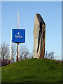
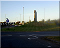
Modern SitesSite Name: Highwood Road Modern MenhirCountry: England
NOTE: This site is 1.802 km away from the location you searched for.
County: Gloucestershire Type: Modern Stone Circle etc
Nearest Town: Bristol Nearest Village: Patchway
Map Ref: ST5928080878
Latitude: 51.525338N Longitude: 2.588339W
Condition:
| 5 | Perfect |
| 4 | Almost Perfect |
| 3 | Reasonable but with some damage |
| 2 | Ruined but still recognisable as an ancient site |
| 1 | Pretty much destroyed, possibly visible as crop marks |
| 0 | No data. |
| -1 | Completely destroyed |
| 5 | Superb |
| 4 | Good |
| 3 | Ordinary |
| 2 | Not Good |
| 1 | Awful |
| 0 | No data. |
| 5 | Can be driven to, probably with disabled access |
| 4 | Short walk on a footpath |
| 3 | Requiring a bit more of a walk |
| 2 | A long walk |
| 1 | In the middle of nowhere, a nightmare to find |
| 0 | No data. |
| 5 | co-ordinates taken by GPS or official recorded co-ordinates |
| 4 | co-ordinates scaled from a detailed map |
| 3 | co-ordinates scaled from a bad map |
| 2 | co-ordinates of the nearest village |
| 1 | co-ordinates of the nearest town |
| 0 | no data |
Internal Links:
External Links:
")
You may be viewing yesterday's version of this page. To see the most up to date information please register for a free account.
Do not use the above information on other web sites or publications without permission of the contributor.
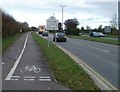
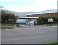
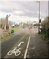
Nearby Images from Geograph Britain and Ireland:
©2007(licence)
©2007(licence)
©2010(licence)
©2010(licence)
©2014(licence)
The above images may not be of the site on this page, they are loaded from Geograph.
Please Submit an Image of this site or go out and take one for us!
Click here to see more info for this site
Nearby sites
Key: Red: member's photo, Blue: 3rd party photo, Yellow: other image, Green: no photo - please go there and take one, Grey: site destroyed
Download sites to:
KML (Google Earth)
GPX (GPS waypoints)
CSV (Garmin/Navman)
CSV (Excel)
To unlock full downloads you need to sign up as a Contributory Member. Otherwise downloads are limited to 50 sites.
Turn off the page maps and other distractions
Nearby sites listing. In the following links * = Image available
2.5km N 8° Knole Park Camp* Hillfort (ST59638334)
3.3km SSW 204° Southmead Barrow* Round Barrow(s) (ST5794477902)
4.1km SSE 150° Stoke Park Long Barrow* Long Barrow (ST6132077294)
4.2km SW 233° Blaise Castle* Hillfort (ST55857837)
4.6km SW 233° King's Weston Hillfort* Hillfort (ST55597813)
4.8km SW 234° King's Weston Hill stockpound* Misc. Earthwork (ST55417807)
5.1km SW 234° King's Weston Hill barrow cemetary* Barrow Cemetery (ST55127793)
5.6km NNE 16° Rams Well* Holy Well or Sacred Spring (ST6085186266)
5.6km SE 134° Oldbury Court Camp Ancient Village or Settlement (ST633769)
5.7km SSW 214° Druid Stoke* Chambered Tomb (ST56107620)
5.9km N 10° Miles Well* Holy Well or Sacred Spring (ST6036486654)
6.1km SSW 192° Redland Park* Standing Stone (Menhir) (ST57947492)
6.2km ESE 106° Bury Hill Camp (Winterbourne)* Hillfort (ST652791)
7.1km S 171° Armoury Square Standing Stone (Menhir) (ST60287386)
7.5km NNE 32° Fishmonger's Swallet Cave or Rock Shelter (ST63318720)
7.7km N 11° Elberton Camp* Hillfort (ST60808840)
7.8km S 189° Bristol City Museum* Museum (ST58057321)
7.9km ESE 103° The Beeracres Stone* Modern Stone Circle etc (ST6779)
8.1km SSW 199° Clifton Down Camp* Hillfort (ST56587329)
8.1km NNE 24° Alveston Round Barrow* Round Barrow(s) (ST62608831)
8.3km SSW 203° Stokeleigh Camp* Promontory Fort / Cliff Castle (ST560733)
8.4km SW 215° Abbots Leigh Churchyard Cross* Ancient Cross (ST5445274007)
8.5km SSW 201° Burwalls Camp* Promontory Fort / Cliff Castle (ST562730)
8.8km SSE 160° St Ann's Well (Brislington)* Holy Well or Sacred Spring (ST6217472515)
9.1km ESE 119° Shortwood Circle* Modern Stone Circle etc (ST67277642)
View more nearby sites and additional images


 We would like to know more about this location. Please feel free to add a brief description and any relevant information in your own language.
 Wir möchten mehr über diese Stätte erfahren. Bitte zögern Sie nicht, eine kurze Beschreibung und relevante Informationen in Deutsch hinzuzufügen.
 Nous aimerions en savoir encore un peu sur les lieux. S'il vous plaît n'hesitez pas à ajouter une courte description et tous les renseignements pertinents dans votre propre langue.
 Quisieramos informarnos un poco más de las lugares. No dude en añadir una breve descripción y otros datos relevantes en su propio idioma.