<< Other Photo Pages >> Race Rocks Ecological Reserve - Ring Cairn in Canada
Submitted by AKFisher on Tuesday, 09 January 2024 Page Views: 171
Pre-ColumbianSite Name: Race Rocks Ecological Reserve Alternative Name: Race Rocks Burial CairnsCountry: Canada
NOTE: This site is 67.53 km away from the location you searched for.
Type: Ring Cairn
Nearest Town: Victoria BC, Canada
Latitude: 48.299230N Longitude: 123.53267W
Condition:
| 5 | Perfect |
| 4 | Almost Perfect |
| 3 | Reasonable but with some damage |
| 2 | Ruined but still recognisable as an ancient site |
| 1 | Pretty much destroyed, possibly visible as crop marks |
| 0 | No data. |
| -1 | Completely destroyed |
| 5 | Superb |
| 4 | Good |
| 3 | Ordinary |
| 2 | Not Good |
| 1 | Awful |
| 0 | No data. |
| 5 | Can be driven to, probably with disabled access |
| 4 | Short walk on a footpath |
| 3 | Requiring a bit more of a walk |
| 2 | A long walk |
| 1 | In the middle of nowhere, a nightmare to find |
| 0 | No data. |
| 5 | co-ordinates taken by GPS or official recorded co-ordinates |
| 4 | co-ordinates scaled from a detailed map |
| 3 | co-ordinates scaled from a bad map |
| 2 | co-ordinates of the nearest village |
| 1 | co-ordinates of the nearest town |
| 0 | no data |
Internal Links:
External Links:
")
Race Rocks Ecological Reserve is a BC Parks ecological reserve off the southern tip of Vancouver Island in the Strait of Juan de Fuca in Metchosin, British Columbia, Canada.
Description:
Located at a narrow part of the Strait, the area covers 3 km2 (1.2 sq mi) of ocean, rocks, and reefs, but does not include the small envelope of land with the foghorn and the historic Race Rocks Lighthouse itself. That area is leased by the Canadian Coast Guard.
Because of the location in a high tidal current area, there is an exceptional variety of marine life to be found, including marine mammals, sea birds, fish, marine invertebrates, and marine algae and sea grass. It is a haulout area for California and Northern sealions and a birthing rookery for Harbour seals and it is also the most northerly birthing colony on the Pacific Coast of North America for the elephant seal, Mirounga angustirostris.[1]
The configuration of the rocks in several stone mounds at Race Rocks are suggestive of First Nations use of this area for burials in the period AD 500. Investigation into sites on the lower part of Vancouver Island, have shown that over 400 such sites exist on the nearby Rocky Point area.[2]
The following is information from Darcy Mathews, (then MA Candidate) University of Victoria, Department of Anthropology. Supervisor: Quentin Mackie
Topical Areas of Interest: Burial cairns, mortuary theory and monumentality, social identity, wetsite archaeology, Culture history of the Northern Strait of Georgia Geographical Areas of Interest: Greater Victoria, the northern Strait of Georgia
Working Title of Thesis: "The Late Prehistoric Mortuary Landscape of Southern Vancouver Island”
Abstract:
In the southern Strait of Georgia, the symbolism employed in burial practices changed significantly between the Marpole and Late Prehistoric Periods, with flexed midden burials replaced by interments in cairns and mounds. I hypothesize that the new arrangement and use of mortuary space is the material expression of emerging social structures and possibly the concept of a shared Straits Salish identity-a process that is archaeologically visible at the regional, local, and site-specific levels. To explore the multifaceted role of burial cairns as a shared and mutually understood means by which peoples constructed, maintained, and contested social structure, I am employing a multi-scalar analysis of cairn distribution. The three scales of analysis include the macro distribution of cairn sites in the Strait of Georgia, the location of cairn sites within three sample landscapes in Greater Victoria, and the layout and structure of individual cairns within DbRv-3, a very large cairn site at Rocky Point in Metchosin.[3]
References:
[1] Wikipedia.org - en.wikipedia.org/wiki/Race_Rocks_Ecological_Reserve
[2] Fletcher, G. (website current) "First Nations Burial Cairns at Great Race Rocks." racerocks.ca/history-of-race-rocks/first-nations-burial-cairns-at-great-race-rocks/
[3] Matthews, D. 2006, "Burial Cairn Taxonomy and the MortuaryLandscape of Rocky Point, British Columbia" University of Victoria, BC Canada
Further reading and information:
1. Race Rocks.ca website: racerocks.ca/history-of-race-rocks/first-nations-burial-cairns-at-great-race-rocks/
2. Friends of Ecological Reserves: ecoreserves.bc.ca/2006/04/30/first-nations-burial-cairns-at-race-rocks-darcy-mathews/
3. Darcy Matthews thesis (full .pdf): http://www.academia.edu/473371/Burial_Cairn_Taxonomy_and_the_Mortuary_Landscape_of_Rocky_Point_British_Columbia
Directions:
Currently, the islands of Race Rocks are Crown Land of the BC Government. BC Parks administers the island as a Provincial Ecological Reserve. It leases to the Canadian Coast Guard, ( a division of the Department of Fisheries and Oceans,) the envelope of land around the light tower, which also includes the vertical solar panel unit and fog horn. BC Parks has given Lester B.Pearson College a 30 year lease to manage the ecological reserve, and all the facilities not leased by the Canadian Coast Guard on the island. The area still remains a Marine Protected Area—Area of Interest.
See below link for specific location information and access permitting: racerocks.ca/administration-of-race-rocks/regulations-for-using-the-race-rocks-marine-research-centre/permit-for-using-the-facilities-at-race-rocks-ecological-reserve/
You may be viewing yesterday's version of this page. To see the most up to date information please register for a free account.
Do not use the above information on other web sites or publications without permission of the contributor.
Nearby Images from Flickr
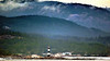
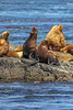
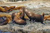
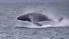
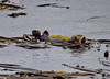
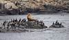
The above images may not be of the site on this page, but were taken nearby. They are loaded from Flickr so please click on them for image credits.
Click here to see more info for this site
Nearby sites
Click here to view sites on an interactive map of the areaKey: Red: member's photo, Blue: 3rd party photo, Yellow: other image, Green: no photo - please go there and take one, Grey: site destroyed
Download sites to:
KML (Google Earth)
GPX (GPS waypoints)
CSV (Garmin/Navman)
CSV (Excel)
To unlock full downloads you need to sign up as a Contributory Member. Otherwise downloads are limited to 50 sites.
Turn off the page maps and other distractions
Nearby sites listing. In the following links * = Image available
19.3km SSE 165° Tse-whit-zen Barrow Cemetery
80.6km W 276° Makah Cultural and Research Center Museum
86.4km NNE 21° Tsawwassen Long House Site* Ancient Village or Settlement
89.5km W 260° Wedding Rock* Rock Art
90.0km W 261° Ozette Ancient Village or Settlement
93.7km NNW 348° Cedar by the Sea Petroglyphs* Rock Art
94.2km N 352° Degnen Bay Site* Rock Art
96.5km NNE 34° P'Quals White Rock* Natural Stone / Erratic / Other Natural Feature
97.8km SE 131° Haleets* Rock Art
97.9km NNW 343° Petroglyph Provincial Park (British Columbia)* Rock Art
101.3km NNW 348° Lock Bay Site* Rock Art
104.9km NNE 24° Sewqueqsen Settlement at St.Mungo Cannery* Ancient Village or Settlement
105.4km NNE 24° Glenrose Cannery* Ancient Village or Settlement
109.7km N 10° Museum of Anthropology - University of British Columbia* Museum
115.4km NNE 15° Xwayzway Village* Ancient Village or Settlement
115.4km SE 127° Burke Museum of Natural History and Culture* Museum
115.6km NNE 14° Skalsh Rock* Rock Outcrop
115.9km NNE 14° Coast Salish Stone Fish Weir* Stone Row / Alignment
130.8km NE 49° Sumas Lightning Rock* Natural Stone / Erratic / Other Natural Feature
131.3km SSE 159° Qwu?gwes Ancient Village or Settlement
131.6km N 353° shíshálh Nation tems swiya Museum Museum
133.5km NE 44° Xaytem Ancient Native Settlement* Ancient Village or Settlement
148.8km N 354° Salmon Inlet Barrow Cemetery
149.9km NW 318° Sproat Lake Petroglyphs* Rock Art
161.9km SE 141° Skystone* Natural Stone / Erratic / Other Natural Feature
View more nearby sites and additional images


 We would like to know more about this location. Please feel free to add a brief description and any relevant information in your own language.
 Wir möchten mehr über diese Stätte erfahren. Bitte zögern Sie nicht, eine kurze Beschreibung und relevante Informationen in Deutsch hinzuzufügen.
 Nous aimerions en savoir encore un peu sur les lieux. S'il vous plaît n'hesitez pas à ajouter une courte description et tous les renseignements pertinents dans votre propre langue.
 Quisieramos informarnos un poco más de las lugares. No dude en añadir una breve descripción y otros datos relevantes en su propio idioma.