<< Our Photo Pages >> Linton Churchyard Cross - Ancient Cross in England in Yorkshire (North)
Submitted by Sunny100 on Saturday, 17 July 2010 Page Views: 6967
Early Medieval (Dark Age)Site Name: Linton Churchyard Cross Alternative Name: St Michael & All Angels Cross, The Linton CrossCountry: England
NOTE: This site is 0.756 km away from the location you searched for.
County: Yorkshire (North) Type: Ancient Cross
Nearest Town: Grassington Nearest Village: Linton-in-Craven
Map Ref: SE0053963220
Latitude: 54.064922N Longitude: 1.993257W
Condition:
| 5 | Perfect |
| 4 | Almost Perfect |
| 3 | Reasonable but with some damage |
| 2 | Ruined but still recognisable as an ancient site |
| 1 | Pretty much destroyed, possibly visible as crop marks |
| 0 | No data. |
| -1 | Completely destroyed |
| 5 | Superb |
| 4 | Good |
| 3 | Ordinary |
| 2 | Not Good |
| 1 | Awful |
| 0 | No data. |
| 5 | Can be driven to, probably with disabled access |
| 4 | Short walk on a footpath |
| 3 | Requiring a bit more of a walk |
| 2 | A long walk |
| 1 | In the middle of nowhere, a nightmare to find |
| 0 | No data. |
| 5 | co-ordinates taken by GPS or official recorded co-ordinates |
| 4 | co-ordinates scaled from a detailed map |
| 3 | co-ordinates scaled from a bad map |
| 2 | co-ordinates of the nearest village |
| 1 | co-ordinates of the nearest town |
| 0 | no data |
Internal Links:
External Links:
")
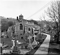
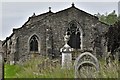
In the churchyard of St Michael & All Angels Church there is the shaft of an old cross standing on a stepped base - four sizable square-shaped stones.
The original Saxon cross-shaft was stolen. It is, according to the church guide, the rough stone base that is Anglo Saxon in origin. It probably dates from the 7th or 8th century, while the shaft is medieval. A sundial used to sit on top of the shaft; this is now in the church.
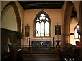
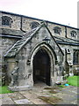
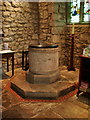
The church stands on a pagan site, but in the 7th century it was Christianised by either St Wilfred or St Paulinus. There is good evidence for this because, in the field opposite, there is what could be part of a pagan stone circle. The church dates from 1150 AD and houses an interesting Norman tub font (1150) and an altar slab bearing five incised crosses. There is a green man on a roof boss.
Sadly, there used to be a brass crucifix, dating from the 9th or 10th century. This was found in 1935 in a nearby ford. It was displayed in the church, but in 1980 it was stolen and has not been recovered. Only a photo and a plaque on a pillar recall this beautiful treasure. Two nice ladies in the church, one who lives in the village, told me about the history of the church and what could be a pagan stone circle.
The church is apparently haunted by a monk who had lived at a nearby abbey.
You may be viewing yesterday's version of this page. To see the most up to date information please register for a free account.
")
Do not use the above information on other web sites or publications without permission of the contributor.
Nearby Images from Geograph Britain and Ireland:
©2008(licence)
©2008(licence)
©2008(licence)
©2007(licence)
©2019(licence)
The above images may not be of the site on this page, they are loaded from Geograph.
Please Submit an Image of this site or go out and take one for us!
Click here to see more info for this site
Nearby sites
Key: Red: member's photo, Blue: 3rd party photo, Yellow: other image, Green: no photo - please go there and take one, Grey: site destroyed
Download sites to:
KML (Google Earth)
GPX (GPS waypoints)
CSV (Garmin/Navman)
CSV (Excel)
To unlock full downloads you need to sign up as a Contributory Member. Otherwise downloads are limited to 50 sites.
Turn off the page maps and other distractions
Nearby sites listing. In the following links * = Image available
120m WSW 249° The Linton Stones* Natural Stone / Erratic / Other Natural Feature (SE0042763177)
1.6km S 171° Ebolton Cave* Cave or Rock Shelter (SE008616)
1.9km NNW 340° Cove Hole* Cave or Rock Shelter (SD99896499)
2.1km N 353° Grassington Settlement Ancient Village or Settlement (SE0027765259)
2.4km NNE 22° Yarnbury Henge* Henge (SE0140665415)
2.4km NNE 16° Yarnbury Settlement (Grassington) Ancient Village or Settlement (SE012655)
2.5km ENE 70° Dumpit Hill Enclosure Ancient Village or Settlement (SE0288464062)
2.5km WNW 295° Little Wood* Ancient Village or Settlement (SD98266429)
2.6km ENE 65° Mossy Moor Reservoir* Ring Cairn (SE02866432)
2.6km ENE 73° Dumpit Hill* Stone Circle (SE02996399)
2.7km ENE 72° Dumpit Hill B (Hebden) Stone Circle (SE03076406)
3.2km ESE 123° Burnsall Crosses* Ancient Cross (SE032615)
3.2km WNW 304° Brazen Gate* Round Cairn (SD9785964995)
3.2km NNW 341° Lea Green cairn Cairn (SD995663)
3.7km NW 305° Chapel House Wood* Ancient Village or Settlement (SD9750165316)
3.8km E 88° Hartlington Pasture 01* Rock Art (SE04396338)
3.9km NNE 30° Grassington A* Stone Circle (SE025666)
4.0km NNE 29° Grassington B* Stone Circle (SE025667)
4.2km E 83° Hartlington Pasture 02* Rock Art (SE04676373)
4.3km WNW 289° Heights Cave* Cave or Rock Shelter (SD96446460)
4.4km N 10° Green Hill Pasture Stone Circle* Stone Circle (SE013676)
5.1km ENE 59° Blea Gill* Ancient Village or Settlement (SE04946588)
5.4km WNW 288° Hammond Close (Threshfield)* Ancient Village or Settlement (SD95386492)
5.5km SW 217° St Peter's Church (Rylstone) Ancient Cross (SD972588)
5.7km WNW 290° Hammond Close Stone (Threshfield) Standing Stones (SD9516165209)
View more nearby sites and additional images


 We would like to know more about this location. Please feel free to add a brief description and any relevant information in your own language.
 Wir möchten mehr über diese Stätte erfahren. Bitte zögern Sie nicht, eine kurze Beschreibung und relevante Informationen in Deutsch hinzuzufügen.
 Nous aimerions en savoir encore un peu sur les lieux. S'il vous plaît n'hesitez pas à ajouter une courte description et tous les renseignements pertinents dans votre propre langue.
 Quisieramos informarnos un poco más de las lugares. No dude en añadir una breve descripción y otros datos relevantes en su propio idioma.