

<< Our Photo Pages >> The Lords Seat - Round Barrow(s) in England in Derbyshire
Submitted by vicky on Wednesday, 18 September 2002 Page Views: 6636
Neolithic and Bronze AgeSite Name: The Lords SeatCountry: England
NOTE: This site is 0.192 km away from the location you searched for.
County: Derbyshire Type: Round Barrow(s)
Nearest Town: Chapel-en-le-Frith Nearest Village: Sparrowpit
Map Ref: SK112835 Landranger Map Number: 110
Latitude: 53.348275N Longitude: 1.833221W
Condition:
| 5 | Perfect |
| 4 | Almost Perfect |
| 3 | Reasonable but with some damage |
| 2 | Ruined but still recognisable as an ancient site |
| 1 | Pretty much destroyed, possibly visible as crop marks |
| 0 | No data. |
| -1 | Completely destroyed |
| 5 | Superb |
| 4 | Good |
| 3 | Ordinary |
| 2 | Not Good |
| 1 | Awful |
| 0 | No data. |
| 5 | Can be driven to, probably with disabled access |
| 4 | Short walk on a footpath |
| 3 | Requiring a bit more of a walk |
| 2 | A long walk |
| 1 | In the middle of nowhere, a nightmare to find |
| 0 | No data. |
| 5 | co-ordinates taken by GPS or official recorded co-ordinates |
| 4 | co-ordinates scaled from a detailed map |
| 3 | co-ordinates scaled from a bad map |
| 2 | co-ordinates of the nearest village |
| 1 | co-ordinates of the nearest town |
| 0 | no data |
Internal Links:
External Links:
I have visited· I would like to visit
Couplands visited on 21st Jan 2023 - their rating: Cond: 2 Amb: 4 Access: 3
")
Have you visited this site? Please add a comment below.
You may be viewing yesterday's version of this page. To see the most up to date information please register for a free account.
")
")
Do not use the above information on other web sites or publications without permission of the contributor.
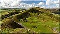
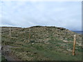
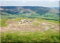
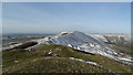
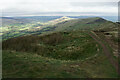
Nearby Images from Geograph Britain and Ireland:
©2023(licence)
©2015(licence)
©2013(licence)
©2018(licence)
©2021(licence)
The above images may not be of the site on this page, they are loaded from Geograph.
Please Submit an Image of this site or go out and take one for us!
Click here to see more info for this site
Nearby sites
Key: Red: member's photo, Blue: 3rd party photo, Yellow: other image, Green: no photo - please go there and take one, Grey: site destroyed
Download sites to:
KML (Google Earth)
GPX (GPS waypoints)
CSV (Garmin/Navman)
CSV (Excel)
To unlock full downloads you need to sign up as a Contributory Member. Otherwise downloads are limited to 50 sites.
Turn off the page maps and other distractions
Nearby sites listing. In the following links * = Image available
1.5km E 86° Mam Tor Barrow Round Barrow(s) (SK127836)
1.6km E 83° Mam Tor* Hillfort (SK128837)
2.3km S 188° Perryfoot Long Barrow (SK109812)
2.4km S 171° Eldon Hill* Round Barrow(s) (SK11568114)
2.4km ESE 102° Treak Cliff Sepulchral Cave* Cave or Rock Shelter (SK136830)
2.5km E 81° Russet Well* Holy Well or Sacred Spring (SK137839)
2.6km SSE 162° Eldon Hill 2* Round Barrow(s) (SK12028099)
2.8km W 260° Green Low ringcairn* Ring Cairn (SK084830)
3.0km WSW 247° Ford Hall Cairn (SK084823)
3.2km SSW 206° Harrod Low* Long Barrow (SK098806)
3.5km SSE 149° Ox Low* Round Barrow(s) (SK130805)
3.7km E 101° Lady's well (Cavedale) Holy Well or Sacred Spring (SK148828)
3.7km N 351° Grindsbrook Clough, Edale* Rock Art (SK106872)
3.8km WSW 242° Mag Low* Round Barrow(s) (SK078817)
3.9km ESE 103° Cave Dale 2* Cave or Rock Shelter (SK150826)
4.3km NW 307° Edale Cross* Ancient Cross (SK0772586092)
4.5km NNE 31° Druids' Stone* Natural Stone / Erratic / Other Natural Feature (SK135874)
4.7km SW 216° Ebbing and Flowing Well (Chapel)* Holy Well or Sacred Spring (SK08437972)
5.0km NW 310° Kinderlow Bowl Barrow* Round Barrow(s) (SK073867)
5.2km NE 42° The Druids Altar Round Barrow(s) (SK147874)
5.2km NW 320° Cluther Rocks* Ancient Mine, Quarry or other Industry (SK078875)
5.6km E 96° The Folly Round Barrow(s) (SK168829)
5.7km WSW 244° Nanny's Well (Chapel le Frith) Holy Well or Sacred Spring (SK061810)
5.8km WNW 287° Mount Famine burial cist* Cist (SK056852)
6.0km E 91° St Peter (Hope)* Ancient Cross (SK1725583445)
View more nearby sites and additional images


 We would like to know more about this location. Please feel free to add a brief description and any relevant information in your own language.
 Wir möchten mehr über diese Stätte erfahren. Bitte zögern Sie nicht, eine kurze Beschreibung und relevante Informationen in Deutsch hinzuzufügen.
 Nous aimerions en savoir encore un peu sur les lieux. S'il vous plaît n'hesitez pas à ajouter une courte description et tous les renseignements pertinents dans votre propre langue.
 Quisieramos informarnos un poco más de las lugares. No dude en añadir una breve descripción y otros datos relevantes en su propio idioma.