


<< Our Photo Pages >> Kinderlow Bowl Barrow - Round Barrow(s) in England in Derbyshire
Submitted by DaveDunford on Sunday, 24 July 2005 Page Views: 12602
Neolithic and Bronze AgeSite Name: Kinderlow Bowl Barrow Alternative Name: Kinder Low BarrowCountry: England County: Derbyshire Type: Round Barrow(s)
Nearest Village: Hayfield
Map Ref: SK073867
Latitude: 53.377106N Longitude: 1.891733W
Condition:
| 5 | Perfect |
| 4 | Almost Perfect |
| 3 | Reasonable but with some damage |
| 2 | Ruined but still recognisable as an ancient site |
| 1 | Pretty much destroyed, possibly visible as crop marks |
| 0 | No data. |
| -1 | Completely destroyed |
| 5 | Superb |
| 4 | Good |
| 3 | Ordinary |
| 2 | Not Good |
| 1 | Awful |
| 0 | No data. |
| 5 | Can be driven to, probably with disabled access |
| 4 | Short walk on a footpath |
| 3 | Requiring a bit more of a walk |
| 2 | A long walk |
| 1 | In the middle of nowhere, a nightmare to find |
| 0 | No data. |
| 5 | co-ordinates taken by GPS or official recorded co-ordinates |
| 4 | co-ordinates scaled from a detailed map |
| 3 | co-ordinates scaled from a bad map |
| 2 | co-ordinates of the nearest village |
| 1 | co-ordinates of the nearest town |
| 0 | no data |
Internal Links:
External Links:
")
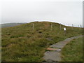
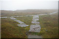
Round barrow at approximately 600m a.s.l. on Kinder Low, a south-western spur of the Kinder Scout plateau, with extensive views to the west. Within Open Access land, reached via part-flagged footpath from Kinderlow End or from the Pennine Way in the vicinity of Edale Rocks. A couple of miles' walk and at least 300m ascent from the nearest road, either from Hayfield via Tunstead Clough Farm or from Edale via Upper Booth and Jacob's Ladder.
Currently (27/07/05) fenced with National Trust sign reading:
Repairs to Kinderlow Bowl Barrow
The monument within this fence is an early Bronze Age (2000-1500BC) burial mound of 'barrow'. Over 500 barrows have been identified across the Peak District. Most are still highly visible in the landscape. Evidence shows that it was normal for between 5 to [sic] 20 burials to be placed individually, in various positions, within a barrow. It is thought that monuments were probably built by family communities, to reflect the importance of ancestry and people's relationship with the land.
The survival of the archaeological deposits within this barrow were threatened by footpath erosion. Recent works have repaired the erosion scar which had developed over the barrow. There was also a walker's cairn on the barrow, constructed out of material from the monument itself. Repairs have involved the infilling and re-turfing of the erosion scar, removal of the cairn and re-routing the footpath around the monument.
The conservation of this important site is being undertaken as a joint project between National Trust, English Heritage and the Peak District National Park Authority Archaeological Service.
It is a Scheduled Monument (monument number:23271) and is protected from damage or destruction in law under the provisions of the Ancient Monuments and Archaeological Areas Act 1979. Please do not do anything that might damage it.
For further information please contact:
- Shane Bates, National Trust Kinder Area Warden, The High Peak Estate Office, Hope, Derbyshire. S33 6RF, Tel. 01433 670368, or
- Sarah Whiteley, Peak District National Park Authority Archaeological Service, Aldern House, Bakewell DE45 1AE, Tel. 01629 816243.
You may be viewing yesterday's version of this page. To see the most up to date information please register for a free account.
Do not use the above information on other web sites or publications without permission of the contributor.
Nearby Images from Geograph Britain and Ireland:
©2005(licence)
©2018(licence)
©2012(licence)
©2006(licence)
©2008(licence)
The above images may not be of the site on this page, they are loaded from Geograph.
Please Submit an Image of this site or go out and take one for us!
Click here to see more info for this site
Nearby sites
Key: Red: member's photo, Blue: 3rd party photo, Yellow: other image, Green: no photo - please go there and take one, Grey: site destroyed
Download sites to:
KML (Google Earth)
GPX (GPS waypoints)
CSV (Garmin/Navman)
CSV (Excel)
To unlock full downloads you need to sign up as a Contributory Member. Otherwise downloads are limited to 50 sites.
Turn off the page maps and other distractions
Nearby sites listing. In the following links * = Image available
741m SE 145° Edale Cross* Ancient Cross (SK0772586092)
942m NNE 32° Cluther Rocks* Ancient Mine, Quarry or other Industry (SK078875)
1.8km W 273° Tunstead Clough* Ancient Village or Settlement (SK055868)
1.9km WSW 249° Fog Field Well* Holy Well or Sacred Spring (SK05578602)
2.0km WNW 285° Upper Dole Field Well* Holy Well or Sacred Spring (SK054872)
2.0km N 3° Mermaid's Pool* Holy Well or Sacred Spring (SK074887)
2.0km WSW 257° White Lady standing stone* Standing Stone (Menhir) (SK0534286250)
2.0km WSW 243° Coldwell Clough Anglo Saxon cross Ancient Cross (SK055858)
2.3km SW 229° Mount Famine burial cist* Cist (SK056852)
2.9km W 270° Whitworth Well* Holy Well or Sacred Spring (SK0437786691)
3.0km NNW 348° Cairn on Kinder Scout Cairn (SK067896)
3.2km N 350° Kinder Scout II Round Barrow(s) (SK06728981)
3.3km W 271° Watery Hey Well* Holy Well or Sacred Spring (SK0399986733)
3.3km E 81° Grindsbrook Clough, Edale* Rock Art (SK106872)
3.5km NNW 346° Kinder Scout I Round Barrow(s) (SK06439014)
3.9km SSE 164° Green Low ringcairn* Ring Cairn (SK084830)
4.5km SSE 166° Ford Hall Cairn (SK084823)
4.9km SW 231° Chinley Churn Barrow Round Barrow(s) (SK035836)
5.0km S 174° Mag Low* Round Barrow(s) (SK078817)
5.0km SE 130° The Lords Seat* Round Barrow(s) (SK112835)
5.8km SSW 192° Nanny's Well (Chapel le Frith) Holy Well or Sacred Spring (SK061810)
6.1km SSW 195° St Thomas Becket (Chapel en le Frith)* Ancient Cross (SK0574580820)
6.2km ESE 120° Mam Tor Barrow Round Barrow(s) (SK127836)
6.2km E 84° Druids' Stone* Natural Stone / Erratic / Other Natural Feature (SK135874)
6.3km ESE 119° Mam Tor* Hillfort (SK128837)
View more nearby sites and additional images


 We would like to know more about this location. Please feel free to add a brief description and any relevant information in your own language.
 Wir möchten mehr über diese Stätte erfahren. Bitte zögern Sie nicht, eine kurze Beschreibung und relevante Informationen in Deutsch hinzuzufügen.
 Nous aimerions en savoir encore un peu sur les lieux. S'il vous plaît n'hesitez pas à ajouter une courte description et tous les renseignements pertinents dans votre propre langue.
 Quisieramos informarnos un poco más de las lugares. No dude en añadir una breve descripción y otros datos relevantes en su propio idioma.