<< Our Photo Pages >> Gouthwaite Lodge Farm - Rock Art in England in Yorkshire (North)
Submitted by Andy B on Saturday, 14 July 2012 Page Views: 7874
Rock ArtSite Name: Gouthwaite Lodge Farm Alternative Name: IAG623b; IAG623c; IAG624dCountry: England
NOTE: This site is 1.94 km away from the location you searched for.
County: Yorkshire (North) Type: Rock Art
Nearest Town: Pateley Bridge Nearest Village: Ramsgill
Map Ref: SE121684
Latitude: 54.111338N Longitude: 1.816412W
Condition:
| 5 | Perfect |
| 4 | Almost Perfect |
| 3 | Reasonable but with some damage |
| 2 | Ruined but still recognisable as an ancient site |
| 1 | Pretty much destroyed, possibly visible as crop marks |
| 0 | No data. |
| -1 | Completely destroyed |
| 5 | Superb |
| 4 | Good |
| 3 | Ordinary |
| 2 | Not Good |
| 1 | Awful |
| 0 | No data. |
| 5 | Can be driven to, probably with disabled access |
| 4 | Short walk on a footpath |
| 3 | Requiring a bit more of a walk |
| 2 | A long walk |
| 1 | In the middle of nowhere, a nightmare to find |
| 0 | No data. |
| 5 | co-ordinates taken by GPS or official recorded co-ordinates |
| 4 | co-ordinates scaled from a detailed map |
| 3 | co-ordinates scaled from a bad map |
| 2 | co-ordinates of the nearest village |
| 1 | co-ordinates of the nearest town |
| 0 | no data |
Be the first person to rate this site - see the 'Contribute!' box in the right hand menu.
Internal Links:
External Links:
I have visited· I would like to visit
Andy B has visited here
")
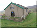
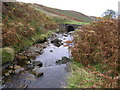
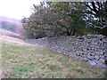
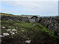
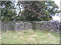
These features are high on the ridge on the west side of Gouthwaite Reservoir, and as of 2011, this complex of possible walls, enclosures and the remains of roundhouses, were under investigation by the Nidderdale Iron Age Project.
More at Prehistoric Nidderdale and read Gillian's article here.
Update December 2018: The rock art panels (Gowthwaite Lodge Farm 01, 02 & 02) have now been recorded in Boughey & Vickerman's "Prehistoric Rock Art of the West Riding Supplement (2018)" and whilst the photographs will appear on this summary page, they now have their own separate pages with more information (see nearby sites below).
Many thanks to Gillian Hovell for the photos and information.
Please seek permission from the landowner at Gouthwaite Farm for permission before visiting.
Note: Rock art walk, Sun 15 July, Exploring Nidderdale's archaeology talk , Mon 16 July, Dacre archaeology walk, Tue 17 July
You may be viewing yesterday's version of this page. To see the most up to date information please register for a free account.
")
")
Do not use the above information on other web sites or publications without permission of the contributor.
Nearby Images from Geograph Britain and Ireland:
©2007(licence)
©2007(licence)
©2007(licence)
©2014(licence)
©2007(licence)
The above images may not be of the site on this page, they are loaded from Geograph.
Please Submit an Image of this site or go out and take one for us!
Click here to see more info for this site
Nearby sites
Key: Red: member's photo, Blue: 3rd party photo, Yellow: other image, Green: no photo - please go there and take one, Grey: site destroyed
Download sites to:
KML (Google Earth)
GPX (GPS waypoints)
CSV (Garmin/Navman)
CSV (Excel)
To unlock full downloads you need to sign up as a Contributory Member. Otherwise downloads are limited to 50 sites.
Turn off the page maps and other distractions
Nearby sites listing. In the following links * = Image available
592m N 3° Gouthwaite Lodge Farm 01* Rock Art (SE1213168992)
597m N 3° Gouthwaite Lodge Farm 02* Rock Art (SE1213468996)
599m N 3° Gouthwaite Lodge Farm 03* Rock Art (SE1213568998)
4.1km N 357° Fountains Earth 01 Rock Art (SE1188572499)
5.8km N 8° Jenny Twig and Tib* Rock Outcrop (SE129741)
6.2km SE 140° Guisecliff Wood (626)* Rock Art (SE1607863641)
6.4km NNW 334° St Chad (Middlesmoor)* Ancient Cross (SE09257414)
6.5km SE 138° Guisecliff Wood (629)* Rock Art (SE1641563565)
6.6km SE 142° Hayshaw Moor North (Dacre) Cairn (SE1621863253)
7.2km SSE 167° Abbot's Hand* Marker Stone (SE138614)
7.3km E 81° Pateley Moor* Standing Stone (Menhir) (SE193695)
7.4km SW 218° High Green (407)* Rock Art (SE0751062601)
7.5km SW 216° Skyreholme Wall Stone (413) Rock Art (SE0772062322)
7.5km NE 51° Fortress Dyke camp* Ancient Village or Settlement (SE1789173178)
7.5km SW 219° Nussey Green (404)* Rock Art (SE07396254)
7.5km SSW 204° Ellers Edge (431) Rock Art (SE0905961506)
7.5km SSW 204° Ellers Edge (432) Rock Art (SE0907861479)
7.5km SSW 204° Eller Edge (429) Rock Art (SE09026150)
7.6km WSW 251° Blea Gill* Ancient Village or Settlement (SE04946588)
7.6km SSW 204° Eller Edge (426) Rock Art (SE0899161486)
7.6km SW 219° Skyreholme (401)* Rock Art (SE07326251)
7.6km SSW 204° Eller Edge (424) Rock Art (SE0897361487)
7.8km SW 227° Appletreewick* Stone Circle (SE0642863048)
7.8km SSW 213° Burhill Kiln (Appletreewick) Rock Art (SE0778761834)
7.9km SSW 213° Skyreholme Rock Art* Rock Art (SE078618)
View more nearby sites and additional images


 We would like to know more about this location. Please feel free to add a brief description and any relevant information in your own language.
 Wir möchten mehr über diese Stätte erfahren. Bitte zögern Sie nicht, eine kurze Beschreibung und relevante Informationen in Deutsch hinzuzufügen.
 Nous aimerions en savoir encore un peu sur les lieux. S'il vous plaît n'hesitez pas à ajouter une courte description et tous les renseignements pertinents dans votre propre langue.
 Quisieramos informarnos un poco más de las lugares. No dude en añadir una breve descripción y otros datos relevantes en su propio idioma.