 with our Megalithic Portal iPhone app")

<< Our Photo Pages >> Toothill Camp - Hillfort in England in Hampshire
Submitted by JimChampion on Monday, 24 January 2005 Page Views: 11393
Iron Age and Later PrehistorySite Name: Toothill CampCountry: England County: Hampshire Type: Hillfort
Nearest Town: Romsey Nearest Village: North Baddesley
Map Ref: SU38151865
Latitude: 50.966013N Longitude: 1.458101W
Condition:
| 5 | Perfect |
| 4 | Almost Perfect |
| 3 | Reasonable but with some damage |
| 2 | Ruined but still recognisable as an ancient site |
| 1 | Pretty much destroyed, possibly visible as crop marks |
| 0 | No data. |
| -1 | Completely destroyed |
| 5 | Superb |
| 4 | Good |
| 3 | Ordinary |
| 2 | Not Good |
| 1 | Awful |
| 0 | No data. |
| 5 | Can be driven to, probably with disabled access |
| 4 | Short walk on a footpath |
| 3 | Requiring a bit more of a walk |
| 2 | A long walk |
| 1 | In the middle of nowhere, a nightmare to find |
| 0 | No data. |
| 5 | co-ordinates taken by GPS or official recorded co-ordinates |
| 4 | co-ordinates scaled from a detailed map |
| 3 | co-ordinates scaled from a bad map |
| 2 | co-ordinates of the nearest village |
| 1 | co-ordinates of the nearest town |
| 0 | no data |
Internal Links:
External Links:
I have visited· I would like to visit
Leatherwood would like to visit
SolarMegalith visited on 24th Jun 2017 - their rating: Cond: 3 Amb: 4 Access: 4
JimChampion have visited here
")
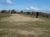
The Camp occupies an extremely strong position at the north end of a spur. Its defences comprise a single rampart and ditch with traces of a counterscarp bank in places. There is an additional scarp on the north side up to 2.0m in height where the site is weakest. The original entrance is onto the ridge to the south.
The hillfort is very prominent in the landscape and is covered with mature redwoods. Its southern aspect can be viewed from Hoe Lane (running from the A3057 to North Baddesley).
You may be viewing yesterday's version of this page. To see the most up to date information please register for a free account.
")
")
")
")
")
")
")
Do not use the above information on other web sites or publications without permission of the contributor.
Click here to see more info for this site
Nearby sites
Key: Red: member's photo, Blue: 3rd party photo, Yellow: other image, Green: no photo - please go there and take one, Grey: site destroyed
Download sites to:
KML (Google Earth)
GPX (GPS waypoints)
CSV (Garmin/Navman)
CSV (Excel)
To unlock full downloads you need to sign up as a Contributory Member. Otherwise downloads are limited to 50 sites.
Turn off the page maps and other distractions
Nearby sites listing. In the following links * = Image available
3.0km SE 127° Castle Hill (Southampton)* Misc. Earthwork (SU40571688)
3.5km ESE 118° Chilworth Ring* Hillfort (SU413170)
4.9km SW 230° Testwood Lakes* Museum (SU344155)
6.7km SW 231° Tatchbury Mount Hillfort (SU330144)
7.3km WSW 241° Money Hills Barrow Cemetery (SU31771505)
8.1km WNW 303° Dunwood Camp Hillfort (SU313230)
8.7km NNE 27° Merdon Castle* Hillfort (SU421264)
8.8km NNW 349° Stubb's Copse Round Barrow(s) (SU36362722)
10.0km WSW 255° Stagbury Hill* Barrow Cemetery (SU285160)
10.2km W 270° Plaitford Barrow* Round Barrow(s) (SU27901852)
10.5km S 191° Longdown (New Forest) tumuli* Round Barrow(s) (SU363083)
10.5km N 8° Withering Corner Barrow Cemetery (SU395291)
10.6km NNE 12° Farley Mount* Round Barrow(s) (SU403290)
10.6km NW 314° Lockerley Camp* Hillfort (SU304259)
11.1km NNE 17° Robin Hood's Barrow (Winchester)* Round Barrow(s) (SU41322927)
11.1km SSW 205° Ashurst Lodge Earthworks* Misc. Earthwork (SU336085)
11.2km NE 42° Texas Barrows* Round Barrow(s) (SU4558926993)
11.3km S 178° Ipley Cross* Round Barrow(s) (SU38670735)
11.4km SSW 204° Matley Heath* Round Barrow(s) (SU336082)
11.7km NNE 22° West Wood Bowl Barrow* Round Barrow(s) (SU42522949)
11.7km NE 48° Compton Down Barrows* Round Barrow(s) (SU46762660)
11.8km ENE 58° Twyford stone circle* Stone Circle (SU481250)
11.8km S 176° The Dibden-Lynch Bottom Ring Henge
12.1km W 271° Landford Common Tumulus* Round Barrow(s) (SU260187)
12.2km S 174° Darcy Island* Round Barrow(s) (SU39520654)
View more nearby sites and additional images


 We would like to know more about this location. Please feel free to add a brief description and any relevant information in your own language.
 Wir möchten mehr über diese Stätte erfahren. Bitte zögern Sie nicht, eine kurze Beschreibung und relevante Informationen in Deutsch hinzuzufügen.
 Nous aimerions en savoir encore un peu sur les lieux. S'il vous plaît n'hesitez pas à ajouter une courte description et tous les renseignements pertinents dans votre propre langue.
 Quisieramos informarnos un poco más de las lugares. No dude en añadir una breve descripción y otros datos relevantes en su propio idioma.