<< Our Photo Pages >> Harting Beacon - Hillfort in England in West Sussex
Submitted by pallcall on Sunday, 21 July 2002 Page Views: 13630
Iron Age and Later PrehistorySite Name: Harting Beacon Alternative Name: Beacon HillCountry: England
NOTE: This site is 1.553 km away from the location you searched for.
County: West Sussex Type: Hillfort
Map Ref: SU806184 Landranger Map Number: 197
Latitude: 50.959399N Longitude: 0.853746W
Condition:
| 5 | Perfect |
| 4 | Almost Perfect |
| 3 | Reasonable but with some damage |
| 2 | Ruined but still recognisable as an ancient site |
| 1 | Pretty much destroyed, possibly visible as crop marks |
| 0 | No data. |
| -1 | Completely destroyed |
| 5 | Superb |
| 4 | Good |
| 3 | Ordinary |
| 2 | Not Good |
| 1 | Awful |
| 0 | No data. |
| 5 | Can be driven to, probably with disabled access |
| 4 | Short walk on a footpath |
| 3 | Requiring a bit more of a walk |
| 2 | A long walk |
| 1 | In the middle of nowhere, a nightmare to find |
| 0 | No data. |
| 5 | co-ordinates taken by GPS or official recorded co-ordinates |
| 4 | co-ordinates scaled from a detailed map |
| 3 | co-ordinates scaled from a bad map |
| 2 | co-ordinates of the nearest village |
| 1 | co-ordinates of the nearest town |
| 0 | no data |
Internal Links:
External Links:
I have visited· I would like to visit
paulcall has visited here
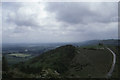
It is a roughly square-shaped contour fort and does not have the large ramparts associated with the middle Iron Age, such as at The Trundle to the east. Much of the bank and ditch is overgrown by scrub, and only the southern bank is easy to pick out nowadays. Both the inside and outside of the fort to the south are arable fields, and they are ploughed right up to the edge of the bank, so this side must be at risk from eventually disappearing under the plough or erosion. The climb up to the top is hard work, but the views are well worth it.
You may be viewing yesterday's version of this page. To see the most up to date information please register for a free account.
Do not use the above information on other web sites or publications without permission of the contributor.
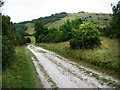
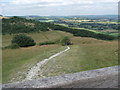
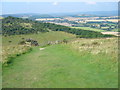
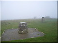
Nearby Images from Geograph Britain and Ireland:
©2008(licence)
©2014(licence)
©2008(licence)
©2008(licence)
©2012(licence)
The above images may not be of the site on this page, they are loaded from Geograph.
Please Submit an Image of this site or go out and take one for us!
Click here to see more info for this site
Nearby sites
Key: Red: member's photo, Blue: 3rd party photo, Yellow: other image, Green: no photo - please go there and take one, Grey: site destroyed
Download sites to:
KML (Google Earth)
GPX (GPS waypoints)
CSV (Garmin/Navman)
CSV (Excel)
To unlock full downloads you need to sign up as a Contributory Member. Otherwise downloads are limited to 50 sites.
Turn off the page maps and other distractions
Nearby sites listing. In the following links * = Image available
2.2km ESE 121° Devil's Jumps* Barrow Cemetery (SU825173)
2.2km SSW 207° Handle Down North* Round Barrow(s) (SU7963616421)
2.4km SSW 203° Handle Down Central* Round Barrow(s) (SU79691619)
2.8km SSW 200° Handle Down South Round Barrow(s) (SU7967815765)
3.3km NW 306° Torberry Hillfort* Hillfort (SU779203)
3.4km SSW 213° Bevis Thumb* Long Barrow (SU7875415513)
4.2km ESE 105° Linch Down* Round Barrow(s) (SU8464517407)
4.4km ESE 105° Linchball Hill* Barrow Cemetery (SU84851735)
4.6km ESE 116° West Dean Woods Barrow Round Barrow(s) (SU8473916465)
4.7km NE 46° Goldrings Warren* Round Barrow(s) (SU8392821677)
4.7km NNW 336° West Heath Barrow Cemetery* Barrow Cemetery (SU78602262)
4.7km ESE 107° Newfarm Plantation Cross Dyke Misc. Earthwork (SU8518117120)
5.0km NE 48° Fitzhall Heath 3* Round Barrow(s) (SU84332180)
5.1km ESE 107° Bepton Down Bowl Barrow* Round Barrow(s) (SU8549716973)
5.1km ESE 108° Bepton Down Platform barrow* Round Barrow(s) (SU8554516928)
5.2km NE 48° Fitzhall Heath 4* Barrow Cemetery (SU8441621923)
5.3km NE 54° Fitzhall Heath 1* Barrow Cemetery (SU849216)
5.4km ENE 59° Minsted Round Barrows* Barrow Cemetery (SU85152125)
5.6km NE 49° Fitzhall Heath 5* Barrow Cemetery (SU8473122134)
5.7km NE 54° Fitzhall Heath 2* Barrow Cemetery (SU8513721803)
5.9km ESE 106° Cocking Down* Round Barrow(s) (SU8629216825)
5.9km NE 39° St Mary's Church (Chithurst) Artificial Mound (SU84252310)
6.3km SSE 158° Goosehill Camp* Hillfort (SU830126)
6.5km SSE 166° Stoughton Long Barrows* Long Barrow (SU823121)
6.5km NW 310° Petersfield Heath Barrows* Barrow Cemetery (SU755225)
View more nearby sites and additional images


 We would like to know more about this location. Please feel free to add a brief description and any relevant information in your own language.
 Wir möchten mehr über diese Stätte erfahren. Bitte zögern Sie nicht, eine kurze Beschreibung und relevante Informationen in Deutsch hinzuzufügen.
 Nous aimerions en savoir encore un peu sur les lieux. S'il vous plaît n'hesitez pas à ajouter une courte description et tous les renseignements pertinents dans votre propre langue.
 Quisieramos informarnos un poco más de las lugares. No dude en añadir una breve descripción y otros datos relevantes en su propio idioma.