


<< Our Photo Pages >> St John The Baptist (Rolleston) - Ancient Cross in England in Leicestershire and Rutland
Submitted by Anne T on Tuesday, 26 June 2018 Page Views: 1172
Early Medieval (Dark Age)Site Name: St John The Baptist (Rolleston)Country: England
NOTE: This site is 3.655 km away from the location you searched for.
County: Leicestershire and Rutland Type: Ancient Cross
Nearest Town: Market Harborough Nearest Village: Rolleston / Skeffington
Map Ref: SK7326200402
Latitude: 52.596483N Longitude: 0.919841W
Condition:
| 5 | Perfect |
| 4 | Almost Perfect |
| 3 | Reasonable but with some damage |
| 2 | Ruined but still recognisable as an ancient site |
| 1 | Pretty much destroyed, possibly visible as crop marks |
| 0 | No data. |
| -1 | Completely destroyed |
| 5 | Superb |
| 4 | Good |
| 3 | Ordinary |
| 2 | Not Good |
| 1 | Awful |
| 0 | No data. |
| 5 | Can be driven to, probably with disabled access |
| 4 | Short walk on a footpath |
| 3 | Requiring a bit more of a walk |
| 2 | A long walk |
| 1 | In the middle of nowhere, a nightmare to find |
| 0 | No data. |
| 5 | co-ordinates taken by GPS or official recorded co-ordinates |
| 4 | co-ordinates scaled from a detailed map |
| 3 | co-ordinates scaled from a bad map |
| 2 | co-ordinates of the nearest village |
| 1 | co-ordinates of the nearest town |
| 0 | no data |
Internal Links:
External Links:
I have visited· I would like to visit
ChristopherJones couldn't find on 15th Dec 2019
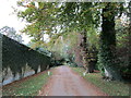
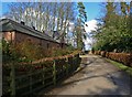
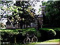
Anne T visited on 24th Jun 2018 - their rating: Cond: 3 Amb: 3 Access: 4 Churchyard Cross, St John The Baptist, Rolleston: Apart from one sign post on the road by the church in Skeffington, this exclusive hamlet may well not exist. The road is gated (at least 3 gates), the roads are very narrow, and at the junction of the road and the bridlepath down to the church, there are a number of ‘no parking’ signs. This meant our daughter-in-law-to-be had to drop us off and drive some distance away, then collect us afterwards.
There is a small iron gate into the churchyard. This appears to be the only entrance, as the road at the eastern end of the church is labelled ‘private’. Eventually managing to open the gate into the church, we found the cross at the south eastern corner of the church, almost hidden in the shadows of the trees. It looked as if the owner of the modern house had incorporated this part of the churchyard into their private garden, so we very much felt like we were trespassing and expected someone to come out of the house and shout at us to ‘move on’.
Due to the heavy shadows and bright sunlight, it was a little difficult to photograph this cross. There appears to be a difference of opinion between Historic England and Pastscape as to the date of this cross – HE says 14th century; Pastscape 17th. The socket stone was marginally intriguing as it had a small hole in each side, presumably to drain any water away.
Making our way back along the gated road to civilisation, we stopped by the stream to let the dog paddle.
 (PID:183112)")
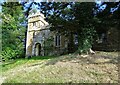
This socket stone and cross shaft are recorded as Pastscape Monument No. 321256 and Historic England List ID 1061690. There appears to be a difference of opinion as to how old this cross is - Historic England says 14th century; Pastscape says 17th century.
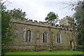
This cross is located at the south east corner of the small church of St. John the Baptist in the hamlet of Rolleston, which is located down a gated road, and is essentially a private estate. There is little parking around the narrow lanes, which have bollards on either side to prevent cars parking; we were eventually dropped off at the entrance to the gated bridleway which led down to the church, and walked the 100 metres or so.
There is a small, black wrought iron gate, largely hidden by a hedge, which leads in to the churchyard (the only other entrance is marked strictly private). The cross is behind the church, at its south eastern end. This part of the churchyard appears to have been incorporated into the private garden of the house next to the church.
The 4.1m high, tapering cross was difficult to photograph as it was virtually hidden under the trees. The 0.9m square, 0.4m high base is curious, as it has a small hole in each side, presumably to drain off any water which trickles down the shaft into the socket stone. The floriated head looks like it may be a more recent addition, as it rises from a very weather carved capital.
You may be viewing yesterday's version of this page. To see the most up to date information please register for a free account.
 (PID:183109)")
 (PID:183110)")
 (PID:183111)")
Do not use the above information on other web sites or publications without permission of the contributor.
Nearby Images from Geograph Britain and Ireland:
©2020(licence)
©2021(licence)
©2021(licence)
©2008(licence)
©2006(licence)
The above images may not be of the site on this page, they are loaded from Geograph.
Please Submit an Image of this site or go out and take one for us!
Click here to see more info for this site
Nearby sites
Key: Red: member's photo, Blue: 3rd party photo, Yellow: other image, Green: no photo - please go there and take one, Grey: site destroyed
Download sites to:
KML (Google Earth)
GPX (GPS waypoints)
CSV (Garmin/Navman)
CSV (Excel)
To unlock full downloads you need to sign up as a Contributory Member. Otherwise downloads are limited to 50 sites.
Turn off the page maps and other distractions
Nearby sites listing. In the following links * = Image available
2.8km NNW 332° Billesdon Cross* Ancient Cross (SK7191302822)
2.8km WSW 248° St Michael's Church (Illston On The Hill)* Ancient Cross (SP7066899287)
4.3km W 272° King's Norton* Holy Well or Sacred Spring (SK6890100495)
5.6km SSW 192° King Charles's Well* Holy Well or Sacred Spring (SP722949)
6.8km SSW 194° St. Ann's Well* Holy Well or Sacred Spring (SP717938)
6.8km NW 318° Ingarsby* Standing Stone (Menhir) (SK6857805373)
7.9km SW 222° The Munt* Artificial Mound (SP6807294487)
10.4km NW 320° Beeby Holy Well* Holy Well or Sacred Spring (SK664083)
10.7km NW 318° Beeby Henge (SK660083)
11.5km E 79° Ridlington settlement Misc. Earthwork (SK846027)
11.7km ENE 59° The Braunston Goddess* Sculptured Stone (SK8324606581)
11.8km NNE 15° Burrough-on-the-hill* Hillfort (SK761119)
12.7km WNW 303° The Humber Stone* Standing Stone (Menhir) (SK6241607095)
13.0km S 178° Peter's Pence Stone* Standing Stone (Menhir) (SP740874)
13.1km N 353° Folville Cross* Ancient Cross (SK715134)
13.1km S 180° Harborough Museum* Museum (SP7342087285)
13.5km NW 323° Mowde Bush Stone* Standing Stone (Menhir) (SK649110)
13.6km NNW 341° The Blue Stone (Gaddesby)* Standing Stone (Menhir) (SK687132)
13.7km ESE 122° Great Easton Roman Well* Holy Well or Sacred Spring (SP850933)
14.1km NNW 327° Queniborough Stones* Standing Stones (SK653121)
14.5km S 189° Judith's Stone.* Marker Stone (SP7120786000)
14.8km SSW 212° Mowsley Stone* Standing Stone (Menhir) (SP657877)
15.6km WNW 286° Jewry Wall Museum Museum (SK582045)
15.6km WNW 289° St. Margaret's Church* Holy Well or Sacred Spring (SK584052)
15.9km NE 48° Langham Lodge Long Barrow (SK850112)
View more nearby sites and additional images


 We would like to know more about this location. Please feel free to add a brief description and any relevant information in your own language.
 Wir möchten mehr über diese Stätte erfahren. Bitte zögern Sie nicht, eine kurze Beschreibung und relevante Informationen in Deutsch hinzuzufügen.
 Nous aimerions en savoir encore un peu sur les lieux. S'il vous plaît n'hesitez pas à ajouter une courte description et tous les renseignements pertinents dans votre propre langue.
 Quisieramos informarnos un poco más de las lugares. No dude en añadir una breve descripción y otros datos relevantes en su propio idioma.