

<< Our Photo Pages >> Mowde Bush Stone - Standing Stone (Menhir) in England in Leicestershire and Rutland
Submitted by enkidu41 on Monday, 16 August 2004 Page Views: 11541
Neolithic and Bronze AgeSite Name: Mowde Bush Stone Alternative Name: Moody Bush StoneCountry: England County: Leicestershire and Rutland Type: Standing Stone (Menhir)
Nearest Town: Melton Mowbray Nearest Village: Queniborough
Map Ref: SK649110
Latitude: 52.692804N Longitude: 1.041191W
Condition:
| 5 | Perfect |
| 4 | Almost Perfect |
| 3 | Reasonable but with some damage |
| 2 | Ruined but still recognisable as an ancient site |
| 1 | Pretty much destroyed, possibly visible as crop marks |
| 0 | No data. |
| -1 | Completely destroyed |
| 5 | Superb |
| 4 | Good |
| 3 | Ordinary |
| 2 | Not Good |
| 1 | Awful |
| 0 | No data. |
| 5 | Can be driven to, probably with disabled access |
| 4 | Short walk on a footpath |
| 3 | Requiring a bit more of a walk |
| 2 | A long walk |
| 1 | In the middle of nowhere, a nightmare to find |
| 0 | No data. |
| 5 | co-ordinates taken by GPS or official recorded co-ordinates |
| 4 | co-ordinates scaled from a detailed map |
| 3 | co-ordinates scaled from a bad map |
| 2 | co-ordinates of the nearest village |
| 1 | co-ordinates of the nearest town |
| 0 | no data |
Internal Links:
External Links:
I have visited· I would like to visit
rierie would like to visit
Humpty13 visited on 21st Jun 2018 - their rating: Cond: 4 Amb: 3 Access: 3 The stone is still standing and is relatively easy to find although the field in which it stands has no public footpath through it and is used for livestock grazing.
")
This stone stood until 1994 in a field to the south of the village of Queniborough marking an ancient trackway from Tilton.
It had a tapering pentagonal shape and, although just about 3' stood above ground, there was reputedly the same amount below ground.
Description by, and used by kind permission of, Bob Trubshaw, from his Interactive Little-known Leicestershire and Rutland CD-ROM.
You may be viewing yesterday's version of this page. To see the most up to date information please register for a free account.
")
")
")
")
Do not use the above information on other web sites or publications without permission of the contributor.
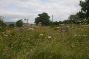
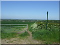
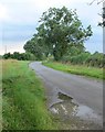
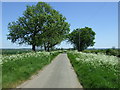
Nearby Images from Geograph Britain and Ireland:
©2012(licence)
©2007(licence)
©2012(licence)
©2009(licence)
©2012(licence)
The above images may not be of the site on this page, they are loaded from Geograph.
Please Submit an Image of this site or go out and take one for us!
Click here to see more info for this site
Nearby sites
Key: Red: member's photo, Blue: 3rd party photo, Yellow: other image, Green: no photo - please go there and take one, Grey: site destroyed
Download sites to:
KML (Google Earth)
GPX (GPS waypoints)
CSV (Garmin/Navman)
CSV (Excel)
To unlock full downloads you need to sign up as a Contributory Member. Otherwise downloads are limited to 50 sites.
Turn off the page maps and other distractions
Nearby sites listing. In the following links * = Image available
1.2km NNE 21° Queniborough Stones* Standing Stones (SK653121)
2.9km SSE 159° Beeby Henge (SK660083)
3.1km SSE 152° Beeby Holy Well* Holy Well or Sacred Spring (SK664083)
3.3km N 350° Rearsby Timber Circle Timber Circle (SK643142)
3.5km N 2° Blue Stone (Rearsby)* Natural Stone / Erratic / Other Natural Feature (SK6497414518)
4.4km ENE 61° The Blue Stone (Gaddesby)* Standing Stone (Menhir) (SK687132)
4.6km SSW 213° The Humber Stone* Standing Stone (Menhir) (SK6241607095)
4.8km WNW 294° Cossington Bronze Age Barrows* Barrow Cemetery (SK605129)
5.7km WSW 248° St James (Birstall) Early Christian Sculptured Stone (SK59630884)
6.5km WNW 285° Rothley Cross* Ancient Cross (SK5861312637)
6.5km NNE 17° Hoby Stone Standing Stone (Menhir) (SK667173)
6.7km SSE 148° Ingarsby* Standing Stone (Menhir) (SK6857805373)
7.0km ENE 71° Folville Cross* Ancient Cross (SK715134)
7.7km NE 39° Stump Cross (Frisby on the Wreake) Ancient Cross (SK6969917032)
8.0km NE 35° Frisby Cross Ancient Cross (SK6942017659)
8.4km W 268° Thurcaston A* Standing Stone (Menhir) (SK56501060)
8.4km W 266° Thurcaston B Standing Stone (Menhir) (SK56481030)
8.5km W 265° Thurcaston C and D Standing Stones (SK56431020)
8.5km WSW 258° Beaumont Leys* Standing Stones (SK566091)
8.7km SW 229° St. Margaret's Church* Holy Well or Sacred Spring (SK584052)
9.0km N 8° Ragdale Stone* Standing Stone (Menhir) (SK661199)
9.3km W 281° Cross (near Swithland)* Ancient Cross (SK557126)
9.3km SW 227° Jewry Wall Museum Museum (SK582045)
9.9km NE 37° All Saints (Asfordby)* Ancient Cross (SK7081218939)
9.9km NE 37° Asfordby Cross* Ancient Cross (SK7078419006)
View more nearby sites and additional images


 We would like to know more about this location. Please feel free to add a brief description and any relevant information in your own language.
 Wir möchten mehr über diese Stätte erfahren. Bitte zögern Sie nicht, eine kurze Beschreibung und relevante Informationen in Deutsch hinzuzufügen.
 Nous aimerions en savoir encore un peu sur les lieux. S'il vous plaît n'hesitez pas à ajouter une courte description et tous les renseignements pertinents dans votre propre langue.
 Quisieramos informarnos un poco más de las lugares. No dude en añadir una breve descripción y otros datos relevantes en su propio idioma.