<< Our Photo Pages >> Dolmen de la Boucharderie - Burial Chamber or Dolmen in France in Poitou:Charente (16)
Submitted by TheCaptain on Saturday, 16 April 2005 Page Views: 5195
Neolithic and Bronze AgeSite Name: Dolmen de la BoucharderieCountry: France
NOTE: This site is 7.641 km away from the location you searched for.
Département: Poitou:Charente (16) Type: Burial Chamber or Dolmen
Nearest Town: Angoulême Nearest Village: Roullet-Saint-Estèph
Latitude: 45.558100N Longitude: 0.025700E
Condition:
| 5 | Perfect |
| 4 | Almost Perfect |
| 3 | Reasonable but with some damage |
| 2 | Ruined but still recognisable as an ancient site |
| 1 | Pretty much destroyed, possibly visible as crop marks |
| 0 | No data. |
| -1 | Completely destroyed |
| 5 | Superb |
| 4 | Good |
| 3 | Ordinary |
| 2 | Not Good |
| 1 | Awful |
| 0 | No data. |
| 5 | Can be driven to, probably with disabled access |
| 4 | Short walk on a footpath |
| 3 | Requiring a bit more of a walk |
| 2 | A long walk |
| 1 | In the middle of nowhere, a nightmare to find |
| 0 | No data. |
| 5 | co-ordinates taken by GPS or official recorded co-ordinates |
| 4 | co-ordinates scaled from a detailed map |
| 3 | co-ordinates scaled from a bad map |
| 2 | co-ordinates of the nearest village |
| 1 | co-ordinates of the nearest town |
| 0 | no data |
Internal Links:
External Links:
I have visited· I would like to visit
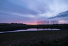
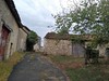
TheCaptain visited on 16th May 2005 - their rating: Cond: 3 Amb: 3 Access: 3 This was a bit of a bugger to find what with road building schemes and diversions taking me miles away and then very narrow lanes with tight corners and no passing places through Cognac vineyard country. There was nothing obvious so I parked and asked people at the farm who gladly pointed me to some trees in the middle of a freshly planted field of maize. “C’est sous l’arbre un tres jolie photo”. I was assured it was OK for me to walk through the field to go and have a look so carefully I did.
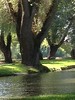
Well hidden under the trees (elder hawthorn and a big walnut tree) is a nice little dolmen with a rectangular chamber about 3 metres by 2 metres with a single capstone on top about a metre thick. There are about 6 support slabs still in place and a few more broken or fallen. Its well liked by rabbits and other local wildlife and the chamber is absolutely full of walnut shells and sweetcorn remains.
")
Its well liked by rabbits and other local wildlife and the chamber is absolutely full of walnut shells and sweetcorn remains.
You may be viewing yesterday's version of this page. To see the most up to date information please register for a free account.
")
")
Do not use the above information on other web sites or publications without permission of the contributor.
Nearby Images from Flickr


The above images may not be of the site on this page, but were taken nearby. They are loaded from Flickr so please click on them for image credits.
Click here to see more info for this site
Nearby sites
Click here to view sites on an interactive map of the areaKey: Red: member's photo, Blue: 3rd party photo, Yellow: other image, Green: no photo - please go there and take one, Grey: site destroyed
Download sites to:
KML (Google Earth)
GPX (GPS waypoints)
CSV (Garmin/Navman)
CSV (Excel)
To unlock full downloads you need to sign up as a Contributory Member. Otherwise downloads are limited to 50 sites.
Turn off the page maps and other distractions
Nearby sites listing. In the following links * = Image available
6.7km ESE 108° Tumulus de Malipougne* Burial Chamber or Dolmen
7.0km E 93° La Chaire a Calvin* Cave or Rock Shelter
10.4km ESE 106° Les Vachons (Voulgezac)* Cave or Rock Shelter
10.5km ESE 105° Grotte des Rois Cave or Rock Shelter
11.5km S 183° La Motte a Dognon* Burial Chamber or Dolmen
14.3km WNW 298° La Pierre Levée (Bouteville) Burial Chamber or Dolmen
16.5km WNW 300° Courades Dolmen* Burial Chamber or Dolmen
17.5km E 84° Dolmen de Brande Burial Chamber or Dolmen
18.0km ENE 73° Dolmen de Pierre Levade Burial Chamber or Dolmen
19.1km W 263° Dolmen dit Gros-Caillou Burial Chamber or Dolmen
20.2km E 87° Dolmen de l'Etang Burial Chamber or Dolmen
21.4km SW 235° Dolmen du Gros-Caillou Burial Chamber or Dolmen
21.6km ESE 105° La Quina* Cave or Rock Shelter
21.7km ESE 106° Le Champignon* Natural Stone / Erratic / Other Natural Feature
22.2km NE 38° La Combe Burial Chamber or Dolmen
22.3km NW 316° La Motte a Poljeau* Chambered Tomb
22.7km ESE 122° Dolmen de Chez Vinaigre* Burial Chamber or Dolmen
23.7km E 85° Le Roc De Sers* Cave or Rock Shelter
25.0km W 274° Saint Fort Dolmen* Burial Chamber or Dolmen
25.9km NW 304° Rocher de la Vache* Burial Chamber or Dolmen
26.1km NW 304° Garde Epée Dolmen* Burial Chamber or Dolmen
26.5km ESE 103° Dolmen de Lambertie* Burial Chamber or Dolmen
26.7km ESE 107° Nécropole d'Edon Barrow Cemetery
27.1km ESE 105° Menhir de la Pierre Debout (Édon) Standing Stone (Menhir)
27.2km ESE 105° Dolmen de la Gélie* Burial Chamber or Dolmen
View more nearby sites and additional images


 We would like to know more about this location. Please feel free to add a brief description and any relevant information in your own language.
 Wir möchten mehr über diese Stätte erfahren. Bitte zögern Sie nicht, eine kurze Beschreibung und relevante Informationen in Deutsch hinzuzufügen.
 Nous aimerions en savoir encore un peu sur les lieux. S'il vous plaît n'hesitez pas à ajouter une courte description et tous les renseignements pertinents dans votre propre langue.
 Quisieramos informarnos un poco más de las lugares. No dude en añadir una breve descripción y otros datos relevantes en su propio idioma.