


<< Text Pages >> Auskerry 11 - Standing Stone (Menhir) in Scotland in Orkney
Submitted by Andy B on Tuesday, 08 November 2022 Page Views: 664
Neolithic and Bronze AgeSite Name: Auskerry 11 Alternative Name: HY61NE 11Country: Scotland County: Orkney Type: Standing Stone (Menhir)
Nearest Town: Island of Stronsay Nearest Village: Island of Auskerry
Map Ref: HY67631630
Latitude: 59.032500N Longitude: 2.565681W
Condition:
| 5 | Perfect |
| 4 | Almost Perfect |
| 3 | Reasonable but with some damage |
| 2 | Ruined but still recognisable as an ancient site |
| 1 | Pretty much destroyed, possibly visible as crop marks |
| 0 | No data. |
| -1 | Completely destroyed |
| 5 | Superb |
| 4 | Good |
| 3 | Ordinary |
| 2 | Not Good |
| 1 | Awful |
| 0 | No data. |
| 5 | Can be driven to, probably with disabled access |
| 4 | Short walk on a footpath |
| 3 | Requiring a bit more of a walk |
| 2 | A long walk |
| 1 | In the middle of nowhere, a nightmare to find |
| 0 | No data. |
| 5 | co-ordinates taken by GPS or official recorded co-ordinates |
| 4 | co-ordinates scaled from a detailed map |
| 3 | co-ordinates scaled from a bad map |
| 2 | co-ordinates of the nearest village |
| 1 | co-ordinates of the nearest town |
| 0 | no data |
Internal Links:
External Links:
Standing Stone (Menhir) in Orkney
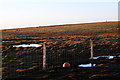
80m NW of HY61NE 7 is the stump and broken-off upper portion, almost grassed over, of another E-W aligned standing stone.
Source: Canmore
You may be viewing yesterday's version of this page. To see the most up to date information please register for a free account.
Do not use the above information on other web sites or publications without permission of the contributor.
Nearby Images from Geograph Britain and Ireland:

©2007(licence)
©2012(licence)

©2007(licence)
©2012(licence)

©2007(licence)
The above images may not be of the site on this page, they are loaded from Geograph.
Please Submit an Image of this site or go out and take one for us!
Click here to see more info for this site
Nearby sites
Key: Red: member's photo, Blue: 3rd party photo, Yellow: other image, Green: no photo - please go there and take one, Grey: site destroyed
Download sites to:
KML (Google Earth)
GPX (GPS waypoints)
CSV (Garmin/Navman)
CSV (Excel)
To unlock full downloads you need to sign up as a Contributory Member. Otherwise downloads are limited to 50 sites.
Turn off the page maps and other distractions
Nearby sites listing. In the following links * = Image available
152m SSE 156° Auskerry 7 Standing Stone (Menhir) (HY67691616)
398m WNW 286° Auskerry 4* Standing Stones (HY6724716413)
540m W 268° Auskerry 5 Standing Stone (Menhir) (HY6708916283)
4.9km N 352° Ward of Houseby (Stronsay) Artificial Mound (HY67022115)
5.1km NNE 15° Lamb Ness (Stronsay) Cairn (HY6898121238)
5.3km NNE 15° Lamb Head Broch* Broch or Nuraghe (HY69052144)
7.1km NNW 348° Stebb Hill (Stronsay) Cairn (HY66262332)
7.6km N 4° Wart of Kirbister (Stronsay) Burial Chamber or Dolmen (HY68282385)
9.8km NW 324° Hillock of Baywest Broch or Nuraghe (HY61902425)
10.4km NW 325° Lochend (Stronsay) Cairn (HY61762487)
11.0km SW 226° Brough of Deerness* Promontory Fort / Cliff Castle (HY59550873)
11.3km NNW 343° Oram's Fancy Cists* Cist (HY64502718)
12.2km N 358° Cutter's Tuo (Stronsay)* Cairn (HY67252847)
12.2km SW 223° Riggan of Kami* Broch or Nuraghe (HY59170743)
12.9km N 356° Earl's Knoll (Papa Stronsay) Cairn (HY66822920)
13.3km SW 221° Deerness Broch or Nuraghe (HY588063)
13.9km SW 219° The Howie* Ancient Village or Settlement (HY58850550)
14.0km W 270° Castle Bloody* Souterrain (Fogou, Earth House) (HY53581644)
14.2km SW 228° Koffer Howe* Artificial Mound (HY56920699)
14.4km WNW 289° Burroughston Broch* Broch or Nuraghe (HY540210)
14.4km SW 229° Millfield* Artificial Mound (HY56700682)
14.5km WSW 245° Castle of Hangie Bay* Stone Fort or Dun (HY54461022)
14.5km WSW 244° The Brough* Ancient Village or Settlement (HY545101)
14.7km SW 225° Howan Blo* Cist (HY571060)
15.2km W 272° Mor Stein* Standing Stone (Menhir) (HY52401685)
View more nearby sites and additional images


 We would like to know more about this location. Please feel free to add a brief description and any relevant information in your own language.
 Wir möchten mehr über diese Stätte erfahren. Bitte zögern Sie nicht, eine kurze Beschreibung und relevante Informationen in Deutsch hinzuzufügen.
 Nous aimerions en savoir encore un peu sur les lieux. S'il vous plaît n'hesitez pas à ajouter une courte description et tous les renseignements pertinents dans votre propre langue.
 Quisieramos informarnos un poco más de las lugares. No dude en añadir una breve descripción y otros datos relevantes en su propio idioma.