

<< Our Photo Pages >> Duniewick - Hillfort in Scotland in South Ayrshire
Submitted by markj99 on Thursday, 25 July 2024 Page Views: 796
Iron Age and Later PrehistorySite Name: DuniewickCountry: Scotland
NOTE: This site is 6.662 km away from the location you searched for.
County: South Ayrshire Type: Hillfort
Nearest Town: Girvan Nearest Village: Ballantrae
Map Ref: NX11628515
Latitude: 55.124812N Longitude: 4.955967W
Condition:
| 5 | Perfect |
| 4 | Almost Perfect |
| 3 | Reasonable but with some damage |
| 2 | Ruined but still recognisable as an ancient site |
| 1 | Pretty much destroyed, possibly visible as crop marks |
| 0 | No data. |
| -1 | Completely destroyed |
| 5 | Superb |
| 4 | Good |
| 3 | Ordinary |
| 2 | Not Good |
| 1 | Awful |
| 0 | No data. |
| 5 | Can be driven to, probably with disabled access |
| 4 | Short walk on a footpath |
| 3 | Requiring a bit more of a walk |
| 2 | A long walk |
| 1 | In the middle of nowhere, a nightmare to find |
| 0 | No data. |
| 5 | co-ordinates taken by GPS or official recorded co-ordinates |
| 4 | co-ordinates scaled from a detailed map |
| 3 | co-ordinates scaled from a bad map |
| 2 | co-ordinates of the nearest village |
| 1 | co-ordinates of the nearest town |
| 0 | no data |
Internal Links:
External Links:
I have visited· I would like to visit
markj99 visited on 17th Jul 2024 - their rating: Cond: 2 Amb: 5 Access: 3 Duniewick Hillfort is sited on Duniewick Crag, a large natural knoll on the NW slope of Knockdolian. It is possible to visit Knockdolian Cairn on the summit of Knockdolian given enough time and energy.
")
Duniewick Hillfort is constructed on Duniewick Crag, a large natural knoll on the NE slopes of Knockdolian, c. 2 miles NE of Ballantrae in South Ayrshire. Dunniewick Crag has near vertical rocky flanks on the S and E providing natural defence. There are steep grassy slopes on the N and W, supplemented by a ditch at the base of the crag. The ditch measures up to 10 feet wide and 4 feet deep. Access to the summit is via an angled rock slab on the W flank. The summit plain slopes gently S-N. It has extensive grass cover making observation difficult. There is an earth rampart round the perimeter with a gap in the W flank for the entrance. Canmore ID 61960 estimates that the rampart is "up to 5.6m in thickness and 0.9m in height". Canmore further states that the enclosure measures c. 30m E-W and 25m N-S. The enclosure is flat and featureless.
You may be viewing yesterday's version of this page. To see the most up to date information please register for a free account.
")
")
")
")
")
")
")
")
")
")
")
")
")
")
")
Do not use the above information on other web sites or publications without permission of the contributor.
Click here to see more info for this site
Nearby sites
Key: Red: member's photo, Blue: 3rd party photo, Yellow: other image, Green: no photo - please go there and take one, Grey: site destroyed
Download sites to:
KML (Google Earth)
GPX (GPS waypoints)
CSV (Garmin/Navman)
CSV (Excel)
To unlock full downloads you need to sign up as a Contributory Member. Otherwise downloads are limited to 50 sites.
Turn off the page maps and other distractions
Nearby sites listing. In the following links * = Image available
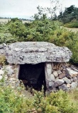
452m SW 218° Knockdolian* Cairn (NX1132784805)
4.5km SW 218° Garleffin* Stone Row / Alignment (NX08738172)
6.8km ESE 113° Arecleoch Standing Stone* Standing Stone (Menhir) (NX178822)
8.5km SSW 199° Carlock Hill Cairn (NX0857377233)
8.9km SE 129° Cave Cairn (Chirmorrie)* Chambered Cairn (NX18317924)
9.0km SE 137° Arecleoch Chambered Cairn Chambered Cairn (NX175783)
10.0km SSW 206° Drumduff Cairn (NX0689176291)
10.4km ENE 72° Glake Stone* Standing Stone (Menhir) (NX21678790)
10.6km ESE 102° Barrhill White Cairn* Cairn (NX21898244)
10.9km S 177° Drummanmoan Loan* Cairn (NX11667427)
11.2km SSW 192° Millmoan Hill* Cairn (NX08897432)
11.2km SSW 205° Penderry Hill Cairn (NX0644175163)
11.5km SSE 147° Cairn Kenny* Passage Grave (NX17467525)
11.6km NE 44° Dinvin Earthworks* Misc. Earthwork (NX2002993173)
12.0km SSE 147° Markdhu White Cairn* Cairn (NX17807486)
12.0km S 184° Friar's Kirk NW* Cairn (NX10197322)
12.1km S 183° Friar's Kirk SE* Cairn (NX10407308)
12.2km SSW 207° Finnarts Hill* Standing Stones (NX05537455)
12.5km S 171° Laganabeastie West* Cairn (NX13007271)
12.5km S 171° Laganbeastie East* Cairn (NX13057271)
12.6km SSW 207° Finnarts Hill Enclosure* Causewayed Enclosure (NX0531174211)
12.8km SSW 208° Finnarts Hill Cairn* Cairn (NX0513274052)
13.0km S 180° Drumanwherran N* Cairn (NX10967212)
13.1km ESE 118° Laggish White Cairn* Cairn (NX22987860)
13.3km S 170° Grey Hill (Shennas)* Cairn (NX13307198)
View more nearby sites and additional images


 We would like to know more about this location. Please feel free to add a brief description and any relevant information in your own language.
 Wir möchten mehr über diese Stätte erfahren. Bitte zögern Sie nicht, eine kurze Beschreibung und relevante Informationen in Deutsch hinzuzufügen.
 Nous aimerions en savoir encore un peu sur les lieux. S'il vous plaît n'hesitez pas à ajouter une courte description et tous les renseignements pertinents dans votre propre langue.
 Quisieramos informarnos un poco más de las lugares. No dude en añadir una breve descripción y otros datos relevantes en su propio idioma.