


<< Our Photo Pages >> Stranraer Museum - Museum in Scotland in Dumfries and Galloway
Submitted by markj99 on Thursday, 23 June 2022 Page Views: 5585
MuseumsSite Name: Stranraer MuseumCountry: Scotland
NOTE: This site is 0.736 km away from the location you searched for.
County: Dumfries and Galloway Type: Museum
Nearest Town: Stranraer
Map Ref: NX0594960839 Landranger Map Number: 82
Latitude: 54.904469N Longitude: 5.028269W
Condition:
| 5 | Perfect |
| 4 | Almost Perfect |
| 3 | Reasonable but with some damage |
| 2 | Ruined but still recognisable as an ancient site |
| 1 | Pretty much destroyed, possibly visible as crop marks |
| 0 | No data. |
| -1 | Completely destroyed |
| 5 | Superb |
| 4 | Good |
| 3 | Ordinary |
| 2 | Not Good |
| 1 | Awful |
| 0 | No data. |
| 5 | Can be driven to, probably with disabled access |
| 4 | Short walk on a footpath |
| 3 | Requiring a bit more of a walk |
| 2 | A long walk |
| 1 | In the middle of nowhere, a nightmare to find |
| 0 | No data. |
| 5 | co-ordinates taken by GPS or official recorded co-ordinates |
| 4 | co-ordinates scaled from a detailed map |
| 3 | co-ordinates scaled from a bad map |
| 2 | co-ordinates of the nearest village |
| 1 | co-ordinates of the nearest town |
| 0 | no data |
Internal Links:
External Links:
I have visited· I would like to visit
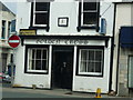
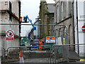
markj99 visited on 22nd Jun 2022 - their rating: Cond: 4 Amb: 3 Access: 5 Stranraer Museum tells the story of Galloway from 7000 BC when people started settling on the coast to the present day. There are stone and bronze axes from all over Galloway and Christian Stones dating from the 5th Century. There are also agricultural and industrial exhibits and a section dedicated to the noted Polar explorer Sir John Ross who was born in Galloway.
")
Address: The Old Town Hall, George Street, DG97JP
Phone: 01776 705088
Opening Hours: 10am-5pm Mon to Fri, 10am-1pm & 2pm-5pm Sat, Closed Sun and the Christmas, New Year, Easter bank hols.
Admission: Free
Visit their web site
Page originally by Vicky.
You may be viewing yesterday's version of this page. To see the most up to date information please register for a free account.
")
")
")
")
Do not use the above information on other web sites or publications without permission of the contributor.
Nearby Images from Geograph Britain and Ireland:
©2010(licence)
©2023(licence)
©2010(licence)
©2022(licence)
©2024(licence)
The above images may not be of the site on this page, they are loaded from Geograph.
Please Submit an Image of this site or go out and take one for us!
Click here to see more info for this site
Nearby sites
Key: Red: member's photo, Blue: 3rd party photo, Yellow: other image, Green: no photo - please go there and take one, Grey: site destroyed
Download sites to:
KML (Google Earth)
GPX (GPS waypoints)
CSV (Garmin/Navman)
CSV (Excel)
To unlock full downloads you need to sign up as a Contributory Member. Otherwise downloads are limited to 50 sites.
Turn off the page maps and other distractions
Nearby sites listing. In the following links * = Image available
379m WNW 303° St John's Well (Stranraer) Holy Well or Sacred Spring (NX05646106)
3.5km ESE 111° Galla Hill* Misc. Earthwork (NX09205941)
4.0km ENE 72° Cairn Macneilie (Inch Parks)* Cairn (NX0985461933)
4.8km SSW 196° Cairn Pat* Hillfort (NX04425632)
5.0km SW 222° Craigenlee Fell E* Cairn (NX02495728)
5.1km NE 48° Teroy Fort* Broch or Nuraghe (NX0992364108)
5.3km SW 223° Craigenlee Fell W* Cairn (NX02155717)
5.4km E 84° Black Loch Crannog* Crannog (NX11396118)
5.6km NNW 329° St Mary's Well (Kilmorie Chapel)* Holy Well or Sacred Spring (NX03286578)
6.0km NE 51° Balker Moor S* Cairn (NX10766444)
6.0km NE 50° Balker Moor N* Cairn (NX10726455)
6.1km E 91° Cults Loch* Crannog (NX12066047)
6.3km NW 304° Tor of Craigoch* Hillfort (NX00856464)
6.4km S 176° St Catherine's Well (Eldrickhill) Holy Well or Sacred Spring (NX06125442)
6.6km NNE 28° Beoch Hill Cairn* Cairn (NX09336654)
6.7km ESE 122° Inch Cursus Cursus (NX11505710)
6.7km ESE 121° Inch Cursus Cursus (NX11555716)
6.8km WSW 242° Knock and Maize* Standing Stone (Menhir) (NW9983057873)
6.9km NNE 28° White Cairn, Beoch Hill* Cairn (NX09436677)
7.1km SW 235° Balmannoch Stone Circle (NX0057)
7.1km NNE 17° Drummuckloch Hill Cairn* Cairn (NX08366756)
7.2km NNE 17° Drummuckloch Hill Standing Stone* Standing Stone (Menhir) (NX08346762)
7.5km W 259° Culdees Holy Well (Knockaldie) Holy Well or Sacred Spring (NW985597)
8.0km SW 229° St Kain's Well (Dunskey Glen) Holy Well or Sacred Spring (NW997558)
8.2km N 6° Cairn Hill (Cairnryan)* Cairn (NX07116896)
View more nearby sites and additional images


 We would like to know more about this location. Please feel free to add a brief description and any relevant information in your own language.
 Wir möchten mehr über diese Stätte erfahren. Bitte zögern Sie nicht, eine kurze Beschreibung und relevante Informationen in Deutsch hinzuzufügen.
 Nous aimerions en savoir encore un peu sur les lieux. S'il vous plaît n'hesitez pas à ajouter une courte description et tous les renseignements pertinents dans votre propre langue.
 Quisieramos informarnos un poco más de las lugares. No dude en añadir una breve descripción y otros datos relevantes en su propio idioma.