


<< Our Photo Pages >> Ambleside Roman Fort - Ancient Village or Settlement in England in Cumbria
Submitted by Horatio on Saturday, 01 July 2023 Page Views: 2780
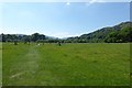
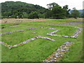
Roman, Greek and ClassicalSite Name: Ambleside Roman Fort Alternative Name: Galava Roman FortCountry: England County: Cumbria Type: Ancient Village or Settlement
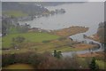
Nearest Town: Ambleside Nearest Village: Waterhead
Map Ref: NY37260339
Latitude: 54.422057N Longitude: 2.96844W
Condition:
| 5 | Perfect |
| 4 | Almost Perfect |
| 3 | Reasonable but with some damage |
| 2 | Ruined but still recognisable as an ancient site |
| 1 | Pretty much destroyed, possibly visible as crop marks |
| 0 | No data. |
| -1 | Completely destroyed |
| 5 | Superb |
| 4 | Good |
| 3 | Ordinary |
| 2 | Not Good |
| 1 | Awful |
| 0 | No data. |
| 5 | Can be driven to, probably with disabled access |
| 4 | Short walk on a footpath |
| 3 | Requiring a bit more of a walk |
| 2 | A long walk |
| 1 | In the middle of nowhere, a nightmare to find |
| 0 | No data. |
| 5 | co-ordinates taken by GPS or official recorded co-ordinates |
| 4 | co-ordinates scaled from a detailed map |
| 3 | co-ordinates scaled from a bad map |
| 2 | co-ordinates of the nearest village |
| 1 | co-ordinates of the nearest town |
| 0 | no data |
Internal Links:
External Links:
")
The fort guarded the Roman road from Brougham to Ravenglass. There is also assumed to have been a road south to the fort at Kendal. In 2016 it was reported that LIDAR technology had revealed a Roman road running north from Ambleside fort to Carlisle, and another running northwest to Papcastle. These roads had been previously described by John Horsley in his Britannia Romana of 1732.
The ruins are a Grade I listed structure. The site is open to the public, and is owned and managed by the National Trust. - Wikipedia
The fort has easy access but parking a car involves driving past the fort and the bends on the A5075 to the parking area on the left just after leaving Waterhead.
You may be viewing yesterday's version of this page. To see the most up to date information please register for a free account.
")
Do not use the above information on other web sites or publications without permission of the contributor.
Nearby Images from Geograph Britain and Ireland:
©2012(licence)
©2017(licence)
![NY3703 : Roman fort [4] by Michael Dibb](https://s0.geograph.org.uk/geophotos/06/23/07/6230760_7ffb2d93_120x120.jpg)
©2019(licence)
![NY3703 : Roman fort [6] by Michael Dibb](https://s2.geograph.org.uk/geophotos/06/23/07/6230762_2b6a6f1a_120x120.jpg)
©2019(licence)
©2015(licence)
The above images may not be of the site on this page, they are loaded from Geograph.
Please Submit an Image of this site or go out and take one for us!
Click here to see more info for this site
Nearby sites
Key: Red: member's photo, Blue: 3rd party photo, Yellow: other image, Green: no photo - please go there and take one, Grey: site destroyed
Download sites to:
KML (Google Earth)
GPX (GPS waypoints)
CSV (Garmin/Navman)
CSV (Excel)
To unlock full downloads you need to sign up as a Contributory Member. Otherwise downloads are limited to 50 sites.
Turn off the page maps and other distractions
Nearby sites listing. In the following links * = Image available
1.4km NNE 13° The Armitt* Museum (NY376048)
2.7km N 352° Rydal Hall Cup Marks Rock Art (NY369061)
5.0km ENE 59° Hird Wood* Stone Circle (NY41630589)
5.5km NW 321° Grasmere Cup-Marked Rocks* Rock Art (NY33850778)
5.6km W 273° Little Langdale Cup-Marked Stone* Rock Art (NY3170003800)
5.7km NW 317° Allan Bank Cup Marked Stone* Rock Art (NY334076)
6.0km NNE 29° The Kirkstone* Natural Stone / Erratic / Other Natural Feature (NY402086)
6.2km WSW 245° Holmes Fell and Uskdale Gap* Cairn (NY316008)
6.3km WNW 292° Copt Howe* Rock Art (NY31400583)
6.7km NE 50° Troutbeck Park Round Cairn 1* Round Cairn (NY4248407616)
6.7km NE 50° Troutbeck Park Round Cairn 2* Round Cairn (NY4250707632)
6.8km SE 127° Bannerrigg Possible Standing Stone* Standing Stone (Menhir) (SD426992)
6.9km ESE 110° Hughill* Ancient Village or Settlement (NY4373900980)
7.0km NE 51° Troutbeck Park Round Cairn 3* Round Cairn (NY4273707734)
7.0km NE 50° Troutbeck Park Round Cairn 4* Round Cairn (NY4274707790)
7.4km NNW 331° Mêni Arthur Natural Stone / Erratic / Other Natural Feature (NY338099)
7.4km S 181° St Helen's Well (Thorpe Hesley) Holy Well or Sacred Spring (SD370960)
7.5km W 268° Castle Howe (Little Langdale)* Hillfort (NY29730328)
8.6km NNE 16° Dovedale enclosure* Ancient Village or Settlement (NY398116)
8.9km WNW 284° Side Pike Stone 1* Rock Art (NY28650560)
8.9km WNW 283° Side Pike* Stone Circle (NY2863005550)
9.0km NE 43° High Street Roman Road* Ancient Trackway (NY43470988)
9.4km NW 313° Grasmere - Far Easedale* Natural Stone / Erratic / Other Natural Feature (NY305099)
9.5km NNW 331° Dunmail Raise* Round Cairn (NY32721170)
9.5km ENE 59° The Ull Stone Natural Stone / Erratic / Other Natural Feature (NY455081)
View more nearby sites and additional images


 We would like to know more about this location. Please feel free to add a brief description and any relevant information in your own language.
 Wir möchten mehr über diese Stätte erfahren. Bitte zögern Sie nicht, eine kurze Beschreibung und relevante Informationen in Deutsch hinzuzufügen.
 Nous aimerions en savoir encore un peu sur les lieux. S'il vous plaît n'hesitez pas à ajouter une courte description et tous les renseignements pertinents dans votre propre langue.
 Quisieramos informarnos un poco más de las lugares. No dude en añadir una breve descripción y otros datos relevantes en su propio idioma.