<< Our Photo Pages >> Hanging Stone (Thimbleby Bank) - Rock Outcrop in England in Yorkshire (North)
Submitted by johndhunter on Tuesday, 24 October 2017 Page Views: 3427
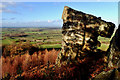
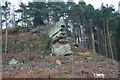
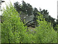
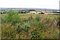
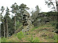
Natural PlacesSite Name: Hanging Stone (Thimbleby Bank)Country: England County: Yorkshire (North) Type: Rock Outcrop
Nearest Village: Over Stilton
Map Ref: SE4501694270
Latitude: 54.342003N Longitude: 1.309084W
Condition:
| 5 | Perfect |
| 4 | Almost Perfect |
| 3 | Reasonable but with some damage |
| 2 | Ruined but still recognisable as an ancient site |
| 1 | Pretty much destroyed, possibly visible as crop marks |
| 0 | No data. |
| -1 | Completely destroyed |
| 5 | Superb |
| 4 | Good |
| 3 | Ordinary |
| 2 | Not Good |
| 1 | Awful |
| 0 | No data. |
| 5 | Can be driven to, probably with disabled access |
| 4 | Short walk on a footpath |
| 3 | Requiring a bit more of a walk |
| 2 | A long walk |
| 1 | In the middle of nowhere, a nightmare to find |
| 0 | No data. |
| 5 | co-ordinates taken by GPS or official recorded co-ordinates |
| 4 | co-ordinates scaled from a detailed map |
| 3 | co-ordinates scaled from a bad map |
| 2 | co-ordinates of the nearest village |
| 1 | co-ordinates of the nearest town |
| 0 | no data |
Internal Links:
External Links:
 (PID:172990)")
You may be viewing yesterday's version of this page. To see the most up to date information please register for a free account.
 (PID:172989)")
 (PID:172988)")
 (PID:172987)")
 (PID:172986)")
Do not use the above information on other web sites or publications without permission of the contributor.
Nearby Images from Geograph Britain and Ireland:
©2018(licence)
©2008(licence)
©2021(licence)
©2013(licence)
©2020(licence)
The above images may not be of the site on this page, they are loaded from Geograph.
Please Submit an Image of this site or go out and take one for us!
Click here to see more info for this site
Nearby sites
Key: Red: member's photo, Blue: 3rd party photo, Yellow: other image, Green: no photo - please go there and take one, Grey: site destroyed
Download sites to:
KML (Google Earth)
GPX (GPS waypoints)
CSV (Garmin/Navman)
CSV (Excel)
To unlock full downloads you need to sign up as a Contributory Member. Otherwise downloads are limited to 50 sites.
Turn off the page maps and other distractions
Nearby sites listing. In the following links * = Image available
2.2km NE 39° Thimbleby Moor 1* Rock Art (SE4639695988)
2.2km NE 43° Thimbleby Moor 2* Rock Art (SE4652595928)
2.3km NE 43° Thimbleby Moor 3* Rock Art (SE4656395961)
2.3km ENE 65° Thimbleby Nine Stones* Standing Stones (SE47099527)
2.5km NE 52° Thimbleby Moor 4* Rock Art (SE4700895837)
3.0km NNE 11° St Peter (Osmotherly)* Ancient Cross (SE45579718)
3.1km E 92° Black Hambleton* Round Barrow(s) (SE4808994185)
3.3km ENE 65° Cray Hall Stone* Marker Stone (SE4797895674)
3.8km ENE 69° Robinsons Cross* Ancient Cross (SE4854895631)
3.8km N 356° St John's Well (Osmotherley)* Holy Well or Sacred Spring (SE447981)
4.0km SSW 205° St Mary (Leake)* Ancient Cross (SE43329063)
4.0km N 359° St John's Well (Northallerton) Holy Well or Sacred Spring (SE449983)
4.3km ESE 106° Whitestones (Arden Great Moor)* Round Barrow(s) (SE4916393116)
4.3km ENE 61° Miley Pike* Round Barrow(s) (SE48769642)
4.7km SSE 149° Penhill Gate Tumuli* Barrow Cemetery (SE4745390251)
4.9km NE 56° Faber´s Stone* Marker Stone (SE4905997023)
5.3km NNE 17° Scarth Wood Moor* Ancient Village or Settlement (SE4650499372)
5.4km SSW 208° St. Helen's Well (Borrowby) Holy Well or Sacred Spring (SE425895)
5.4km SE 145° Gallow Hill Tumuli (Cowesby Moor)* Round Barrow(s) (SE4819789858)
5.6km NE 52° Rye Head BS1* Marker Stone (SE4941697771)
5.7km SE 134° Kepwick Long Barrow* Long Barrow (SE4915590333)
5.8km SE 140° Friar's Cross (Kepwick)* Ancient Cross (SE4879589908)
5.8km ESE 114° Harker Yates Ridge (Arden Great Moor)* Round Barrow(s) (SE5032691940)
5.8km NNE 25° Near Moor 10f* Rock Art (SE4743599539)
5.8km NNE 24° Near Moor 10a Rock Art (SE4735899599)
View more nearby sites and additional images


 We would like to know more about this location. Please feel free to add a brief description and any relevant information in your own language.
 Wir möchten mehr über diese Stätte erfahren. Bitte zögern Sie nicht, eine kurze Beschreibung und relevante Informationen in Deutsch hinzuzufügen.
 Nous aimerions en savoir encore un peu sur les lieux. S'il vous plaît n'hesitez pas à ajouter une courte description et tous les renseignements pertinents dans votre propre langue.
 Quisieramos informarnos un poco más de las lugares. No dude en añadir una breve descripción y otros datos relevantes en su propio idioma.