

<< Our Photo Pages >> Billey Keld - Holy Well or Sacred Spring in England in Yorkshire (West)
Submitted by jamesrattue on Tuesday, 21 October 2008 Page Views: 4939
Springs and Holy WellsSite Name: Billey KeldCountry: England
NOTE: This site is 1.918 km away from the location you searched for.
County: Yorkshire (West) Type: Holy Well or Sacred Spring
Nearest Town: Masham Nearest Village: Grewelthorpe
Map Ref: SE2251376193
Latitude: 54.181027N Longitude: 1.656558W
Condition:
| 5 | Perfect |
| 4 | Almost Perfect |
| 3 | Reasonable but with some damage |
| 2 | Ruined but still recognisable as an ancient site |
| 1 | Pretty much destroyed, possibly visible as crop marks |
| 0 | No data. |
| -1 | Completely destroyed |
| 5 | Superb |
| 4 | Good |
| 3 | Ordinary |
| 2 | Not Good |
| 1 | Awful |
| 0 | No data. |
| 5 | Can be driven to, probably with disabled access |
| 4 | Short walk on a footpath |
| 3 | Requiring a bit more of a walk |
| 2 | A long walk |
| 1 | In the middle of nowhere, a nightmare to find |
| 0 | No data. |
| 5 | co-ordinates taken by GPS or official recorded co-ordinates |
| 4 | co-ordinates scaled from a detailed map |
| 3 | co-ordinates scaled from a bad map |
| 2 | co-ordinates of the nearest village |
| 1 | co-ordinates of the nearest town |
| 0 | no data |
Internal Links:
External Links:
I have visited· I would like to visit
Anne T visited on 31st May 2021 - their rating: Cond: 3 Amb: 3 Access: 4 Billey Keld Well, Grewelthorpe: With some very lively bullocks in the field, we decided not to venture into the field through the gate to look at well. However, we managed to see some of the structure from the roadside.
A local lady walking her dog stopped to talk to us and say she remembers visiting the well to collect water when she was a child.
")
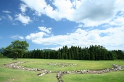
This is a modest spring flowing into a stone surround between two fields west of the village of Grewelthorpe, right on the bend of a small lane, but accessible only through the gate at the t-junction a few yards to the north. It appears on the Ordnance Survey 1:25,000 map but otherwise has no known history or associations. 'Keld' is a common northern word, Scandinavian in origin, meaning 'spring', while 'Billey' could be a version of the word 'pill', 'billing', 'boiling', and other variants, referring to the water bubbling up from the ground.
You may be viewing yesterday's version of this page. To see the most up to date information please register for a free account.
")
")
")
")
")
")
Do not use the above information on other web sites or publications without permission of the contributor.
Click here to see more info for this site
Nearby sites
Key: Red: member's photo, Blue: 3rd party photo, Yellow: other image, Green: no photo - please go there and take one, Grey: site destroyed
Download sites to:
KML (Google Earth)
GPX (GPS waypoints)
CSV (Garmin/Navman)
CSV (Excel)
To unlock full downloads you need to sign up as a Contributory Member. Otherwise downloads are limited to 50 sites.
Turn off the page maps and other distractions
Nearby sites listing. In the following links * = Image available
741m NNW 333° Lime Tree Roundhouse* Modern Stone Circle etc (SE2216776849)
823m NNW 332° Lime Tree Modern Stone Circle* Modern Stone Circle etc (SE2212876922)
1.7km NW 318° Himalayan Gardens & Sculpture Park* Modern Stone Circle etc (SE2139577417)
1.8km ENE 67° Dropping Well* Holy Well or Sacred Spring (SE242769)
3.5km ENE 75° Ings Well (Mickley)* Holy Well or Sacred Spring (SE2593377125)
3.6km NNW 342° Berry Well* Holy Well or Sacred Spring (SE2140479628)
4.2km WNW 297° Skew Skell Well* Holy Well or Sacred Spring (SE1876078084)
4.5km N 2° St Mary (Masham)* Ancient Cross (SE2266080651)
5.0km ENE 59° St Nicholas (West Tanfield)* Ancient Cross (SE2679978746)
5.2km NW 315° Fearby, Masham* Stone Circle (SE188798)
5.2km SSW 205° Cast Hills* Ancient Village or Settlement (SE20377147)
5.2km WSW 248° Carle Tower* Marker Stone (SE177742)
5.4km SW 218° Hell Holme Bank (Dallowgill) Rock Art (SE1917071909)
5.5km WSW 237° Fortress Dyke camp* Ancient Village or Settlement (SE1789173178)
5.6km WNW 297° Swinton Druid's Temple* Modern Stone Circle etc (SE1746478713)
5.7km NNW 333° Fearby Cross (Masham) Ancient Cross (SE1984081273)
6.4km ENE 63° Thornborough Cursus Cursus (SE282791)
6.6km E 96° Castle Dikes Hillfort (SE291755)
6.7km NE 35° St Michael's Well (Well)* Holy Well or Sacred Spring (SE26338175)
6.7km NE 55° Thornborough N* Henge (SE28058005)
6.8km ENE 62° Thornborough Central* Henge (SE28517945)
6.9km ENE 68° Thornborough S* Henge (SE28947884)
7.2km ENE 62° Thornborough Cursus Cursus (SE289796)
7.3km NE 37° St Michael's Church (Well)* Ancient Cross (SE2682982053)
7.3km NW 311° Healey Stone Circles (Masham) Stone Circle (SE170810)
View more nearby sites and additional images

")
 We would like to know more about this location. Please feel free to add a brief description and any relevant information in your own language.
 Wir möchten mehr über diese Stätte erfahren. Bitte zögern Sie nicht, eine kurze Beschreibung und relevante Informationen in Deutsch hinzuzufügen.
 Nous aimerions en savoir encore un peu sur les lieux. S'il vous plaît n'hesitez pas à ajouter une courte description et tous les renseignements pertinents dans votre propre langue.
 Quisieramos informarnos un poco más de las lugares. No dude en añadir una breve descripción y otros datos relevantes en su propio idioma.