<< Our Photo Pages >> Sutton Hall - Round Barrow(s) in England in Cheshire
Submitted by vicky on Monday, 22 July 2002 Page Views: 9934
Neolithic and Bronze AgeSite Name: Sutton HallCountry: England
NOTE: This site is 0.996 km away from the location you searched for.
County: Cheshire Type: Round Barrow(s)
Nearest Town: Macclesfield Nearest Village: Sutton
Map Ref: SJ925713 Landranger Map Number: 118
Latitude: 53.238674N Longitude: 2.113832W
Condition:
| 5 | Perfect |
| 4 | Almost Perfect |
| 3 | Reasonable but with some damage |
| 2 | Ruined but still recognisable as an ancient site |
| 1 | Pretty much destroyed, possibly visible as crop marks |
| 0 | No data. |
| -1 | Completely destroyed |
| 5 | Superb |
| 4 | Good |
| 3 | Ordinary |
| 2 | Not Good |
| 1 | Awful |
| 0 | No data. |
| 5 | Can be driven to, probably with disabled access |
| 4 | Short walk on a footpath |
| 3 | Requiring a bit more of a walk |
| 2 | A long walk |
| 1 | In the middle of nowhere, a nightmare to find |
| 0 | No data. |
| 5 | co-ordinates taken by GPS or official recorded co-ordinates |
| 4 | co-ordinates scaled from a detailed map |
| 3 | co-ordinates scaled from a bad map |
| 2 | co-ordinates of the nearest village |
| 1 | co-ordinates of the nearest town |
| 0 | no data |
Internal Links:
External Links:
I have visited· I would like to visit
gritstone visited on 1st Jun 2020 - their rating: Cond: 2 Amb: 3 Access: 4 Not very impressive, but a nice easy walk with good local pubs close by.
BrownEdger visited on 21st Aug 2011 - their rating: Cond: 2 Amb: 2 Access: 4
Average ratings for this site from all visit loggers: Condition: 2 Ambience: 2.5 Access: 4
")
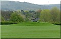
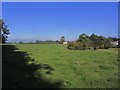
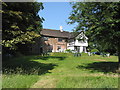
Leaving Macclesfield towards The Forest, the first Parish you come to is that of Sutton. Travelling down Bullocks Lane motorists will come across a somewhat dilapidated Bronze Age barrow (now the resting-place of a water trough), in the field adjacent to the grounds of Sutton Hall.
The following account was relayed to members meeting of the Macclesfield Scientific Society in 1877 in a paper entitled ‘Grave Mound Exploration near Macclesfield’: ‘after a conversation with Miss Bent, and by the permission of Mr Thompstone, the large mound at the rear of Sutton Hall has been opened; there has always been much speculation as to its origin and purpose, and I had hoped by to-night to have been able to say something definite about it, but all I can say is that we have entered it by a trench some twelve feet long, six feet wide and eight feet deep, and have up to the present time found no remains. It is entirely composed of boulders, some split by the action of fire. The investigation will be continued.’
It was to be another 85 years before this happened when it was partially excavated in 1962 by James Forde-Johnston of Manchester University, who had investigated the mound at Gallowsclough in Delamere two years previously. He unearthed a few secondary cremations, but no primary burial and revealed that the mound had originally been around 100 yards in diameter, but was since substantially reduced with many of the river cobbles having been removed to the nearby farmyard. Despite being scheduled, in addition to the damage caused by the cattle that drink from the water tank, the site has suffered from other local wildlife activity. A badger sett can be seen to the south-east, while elsewhere rabbits have made their burrows.
Access
From Macclesfield take the road known as Byrons Lane (off the Macclesfield to Leek Road) towards Sutton. Just before you reach the canal bridge in Gurnet, take the right hand turn into Bullocks Lane. The barrow can either be viewed from the road (from just south of Sutton Hall) or from a public footpath which skirts the field to the east of the site at GR: SJ924715.
References
G. Rowley “Macclesfield in Prehistory” (1982)
D.M.Longley “Prehistory” in C.R.Elrington (ed) “The Victoria History of the County of Chester, volume 1, Oxford University Press (1987)
T.J.Smith “Grave Mound Exploration near Macclesfield”, Proceedings of the Macclesfield Scientific Society (1877-1878)
You may be viewing yesterday's version of this page. To see the most up to date information please register for a free account.
")
")
")
")
Do not use the above information on other web sites or publications without permission of the contributor.
Nearby Images from Geograph Britain and Ireland:
©2018(licence)
©2015(licence)
©2011(licence)

©2017(licence)
©2017(licence)
The above images may not be of the site on this page, they are loaded from Geograph.
Please Submit an Image of this site or go out and take one for us!
Click here to see more info for this site
Nearby sites
Key: Red: member's photo, Blue: 3rd party photo, Yellow: other image, Green: no photo - please go there and take one, Grey: site destroyed
Download sites to:
KML (Google Earth)
GPX (GPS waypoints)
CSV (Garmin/Navman)
CSV (Excel)
To unlock full downloads you need to sign up as a Contributory Member. Otherwise downloads are limited to 50 sites.
Turn off the page maps and other distractions
Nearby sites listing. In the following links * = Image available
1.5km SSW 196° Broad Oak Farm* Round Barrow(s) (SJ921699)
1.8km SSW 196° Gawsworth henge* Henge (SJ920696)
2.0km NNW 336° St Anne's Well (Macclesfield)* Holy Well or Sacred Spring (SJ917731)
2.0km SSW 210° Woodhouse End* Round Barrow(s) (SJ915696)
2.3km NE 34° Macclesfield Common I Round Barrow(s) (SJ938732)
2.3km E 80° Langley Conical mound* Round Barrow(s) (SJ948717)
2.4km NE 53° Teggs Nose Farm Round Barrow(s) (SJ944727)
2.4km NE 35° Macclesfield Common II Round Barrow(s) (SJ939733)
2.6km E 85° High Low* Round Barrow(s) (SJ951715)
2.9km ENE 78° Teggs Nose reservoir* Round Barrow(s) (SJ953719)
3.0km E 84° Higher Ridgegate* Standing Stone (Menhir) (SJ9550671636)
3.1km NNW 333° West Park Boulder* Natural Stone / Erratic / Other Natural Feature (SJ911741)
3.2km NNW 334° West Park Crosses* Ancient Cross (SJ911742)
3.6km NNW 342° Beech Hall Round Barrow(s) (SJ914747)
3.6km NNW 332° Macclesfield Cemetery* Round Barrow(s) (SJ908745)
3.7km ESE 124° The Plague Stone* Ancient Cross (SJ9561269221)
3.8km NNW 343° Lavenham Close* Round Barrow(s) (SJ914749)
4.1km WNW 291° New Farm, Henbury* Stone Circle (SJ887728)
4.4km ENE 73° Charity Lane II Round Barrow(s) (SJ967726)
4.4km ENE 73° Charity Lane III* Round Barrow(s) (SJ967726)
4.6km SE 134° Cessbank Common* Round Barrow(s) (SJ958681)
4.6km ENE 76° Charity Lane I* Round Barrow(s) (SJ970724)
4.6km E 82° Toot Hill Warilow* Round Barrow(s) (SJ971719)
4.6km E 81° Toot Hill* Ancient Village or Settlement (SJ971720)
4.7km NW 324° Prestbury Road (Macclesfield)* Ancient Cross (SJ89727511)
View more nearby sites and additional images


 We would like to know more about this location. Please feel free to add a brief description and any relevant information in your own language.
 Wir möchten mehr über diese Stätte erfahren. Bitte zögern Sie nicht, eine kurze Beschreibung und relevante Informationen in Deutsch hinzuzufügen.
 Nous aimerions en savoir encore un peu sur les lieux. S'il vous plaît n'hesitez pas à ajouter une courte description et tous les renseignements pertinents dans votre propre langue.
 Quisieramos informarnos un poco más de las lugares. No dude en añadir una breve descripción y otros datos relevantes en su propio idioma.