 with our Megalithic Portal iPhone app")


<< Other Photo Pages >> Lincoln Museum - Museum in England in Lincolnshire
Submitted by Andy B on Tuesday, 07 March 2006 Page Views: 13436
MuseumsSite Name: Lincoln Museum Alternative Name: The Usher Gallery, Art and Archaeology in Lincolnshire, The Collection (previous name)Country: England
NOTE: This site is 1.317 km away from the location you searched for.
County: Lincolnshire Type: Museum
Nearest Town: Lincoln
Map Ref: SK9771471547
Latitude: 53.231981N Longitude: 0.537579W
Condition:
| 5 | Perfect |
| 4 | Almost Perfect |
| 3 | Reasonable but with some damage |
| 2 | Ruined but still recognisable as an ancient site |
| 1 | Pretty much destroyed, possibly visible as crop marks |
| 0 | No data. |
| -1 | Completely destroyed |
| 5 | Superb |
| 4 | Good |
| 3 | Ordinary |
| 2 | Not Good |
| 1 | Awful |
| 0 | No data. |
| 5 | Can be driven to, probably with disabled access |
| 4 | Short walk on a footpath |
| 3 | Requiring a bit more of a walk |
| 2 | A long walk |
| 1 | In the middle of nowhere, a nightmare to find |
| 0 | No data. |
| 5 | co-ordinates taken by GPS or official recorded co-ordinates |
| 4 | co-ordinates scaled from a detailed map |
| 3 | co-ordinates scaled from a bad map |
| 2 | co-ordinates of the nearest village |
| 1 | co-ordinates of the nearest town |
| 0 | no data |
Internal Links:
External Links:
Visitors to historic Lincoln can now enjoy a fabulous new, free to enter, Museum, embracing the region's premier art gallery, the Usher.
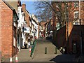
The buildings sit side by side in the centre of the city close to Steep Hill and enjoy spectacular views of Lincoln Cathedral.
The collection includes a wealth of artefacts from the Stone, Bronze and Iron Ages, Roman, Saxon, Viking and Medieval eras as well as fine, decorative and contemporary visual arts.
Link to Lincoln Museum official web site. Danes Terrace, Lincoln, LN2 1LP, Lincolnshire, England T: +44 (0)1522 550990 Open: 10am to 5pm seven days a week Closed: Christmas Eve, Christmas Day, Boxing Day, New Year's Eve and New Year's Day
Note: Iron Age boat on show at Lincoln museum, see comment
You may be viewing yesterday's version of this page. To see the most up to date information please register for a free account.
Do not use the above information on other web sites or publications without permission of the contributor.
davidmorgan has found this location on Google Street View:
Nearby Images from Geograph Britain and Ireland:

©2008(licence)
©2008(licence)

©2015(licence)

©2015(licence)

©2015(licence)
The above images may not be of the site on this page, they are loaded from Geograph.
Please Submit an Image of this site or go out and take one for us!
Click here to see more info for this site
Nearby sites
Key: Red: member's photo, Blue: 3rd party photo, Yellow: other image, Green: no photo - please go there and take one, Grey: site destroyed
Download sites to:
KML (Google Earth)
GPX (GPS waypoints)
CSV (Garmin/Navman)
CSV (Excel)
To unlock full downloads you need to sign up as a Contributory Member. Otherwise downloads are limited to 50 sites.
Turn off the page maps and other distractions
Nearby sites listing. In the following links * = Image available
467m NNW 347° Roman Lincoln Ancient Village or Settlement (SK976720)
2.7km E 101° Lincoln Greetwell Henge/disc barrow* Barrow Cemetery (TF00407110)
3.0km SSW 211° Lincoln stone circle* Modern Stone Circle etc (SK962689)
4.2km E 100° Washingborough Ancient Settlement* Ancient Village or Settlement (TF019709)
4.7km N 7° Riseholme Barrow* Round Barrow(s) (SK98177624)
7.3km E 91° Fiskerton Iron Age causeway* Ancient Village or Settlement (TF05007159)
7.3km NNW 343° St Pancras Well* Holy Well or Sacred Spring (SK954785)
9.8km NW 304° South Ingleby Tumulus Misc. Earthwork (SK8946576860)
11.3km E 81° Barlings Well* Holy Well or Sacred Spring (TF08937347)
16.6km NE 45° Wickenby Ancient Village or Settlement (TF0928883432)
16.9km WSW 245° Besthorpe Ancient Village or Settlement (SK825641)
18.1km N 2° Newell's Well (Glentham) Holy Well or Sacred Spring (SK981897)
18.5km N 355° Aisthorpe springs Holy Well or Sacred Spring (SK956899)
19.5km SW 229° Langford, Brough and Glebe Farm sites on the A46* Ancient Village or Settlement (SK833584)
20.1km NNW 348° St. Helen's Well (Hemswell)* Holy Well or Sacred Spring (SK932911)
21.2km W 276° Kingshaugh* Hillfort (SK765735)
23.1km W 271° Holy well (Tuxford) Holy Well or Sacred Spring (SK745714)
23.7km WNW 287° Lady well (Headon)* Holy Well or Sacred Spring (SK7483877954)
24.4km E 87° Baumber Cursus* Cursus (TF22067350)
24.7km W 268° Holy well ( Tuxford ) Holy Well or Sacred Spring (SK7370)
25.0km SSE 148° Anwick Drake Stones* Natural Stone / Erratic / Other Natural Feature (TF114506)
25.2km WNW 292° Castle Hill (Nottinghamshire) Hillfort (SK741806)
25.7km W 260° The Duck's Mouth* Holy Well or Sacred Spring (SK724667)
26.2km SW 225° Farndon Fields* Natural Stone / Erratic / Other Natural Feature (SK794528)
26.3km NE 39° Walesby All Saints church carvings* Sculptured Stone (TF1382892388)
View more nearby sites and additional images


 We would like to know more about this location. Please feel free to add a brief description and any relevant information in your own language.
 Wir möchten mehr über diese Stätte erfahren. Bitte zögern Sie nicht, eine kurze Beschreibung und relevante Informationen in Deutsch hinzuzufügen.
 Nous aimerions en savoir encore un peu sur les lieux. S'il vous plaît n'hesitez pas à ajouter une courte description et tous les renseignements pertinents dans votre propre langue.
 Quisieramos informarnos un poco más de las lugares. No dude en añadir una breve descripción y otros datos relevantes en su propio idioma.