 with our Megalithic Portal iPhone app")


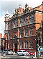
<< Our Photo Pages >> Grosvenor Museum - Museum in England in Cheshire
Submitted by vicky on Wednesday, 12 February 2014 Page Views: 13057
MuseumsSite Name: Grosvenor Museum Alternative Name: Overchurch Rune Stone, Runic Stone, Biddan StoneCountry: England
NOTE: This site is 0.214 km away from the location you searched for.
County: Cheshire Type: Museum
Nearest Town: Chester
Map Ref: SJ40466595 Landranger Map Number: 117
Latitude: 53.187294N Longitude: 2.892496W
Condition:
| 5 | Perfect |
| 4 | Almost Perfect |
| 3 | Reasonable but with some damage |
| 2 | Ruined but still recognisable as an ancient site |
| 1 | Pretty much destroyed, possibly visible as crop marks |
| 0 | No data. |
| -1 | Completely destroyed |
| 5 | Superb |
| 4 | Good |
| 3 | Ordinary |
| 2 | Not Good |
| 1 | Awful |
| 0 | No data. |
| 5 | Can be driven to, probably with disabled access |
| 4 | Short walk on a footpath |
| 3 | Requiring a bit more of a walk |
| 2 | A long walk |
| 1 | In the middle of nowhere, a nightmare to find |
| 0 | No data. |
| 5 | co-ordinates taken by GPS or official recorded co-ordinates |
| 4 | co-ordinates scaled from a detailed map |
| 3 | co-ordinates scaled from a bad map |
| 2 | co-ordinates of the nearest village |
| 1 | co-ordinates of the nearest town |
| 0 | no data |
Internal Links:
External Links:
I have visited· I would like to visit
kthdsn visited on 11th Oct 2014 - their rating: Amb: 3 Access: 5
TimPrevett have visited here
")
Address: 27 Grosvenor Street, CH1 2DD
Phone: 01244 402008
Opening Hours: 10.30 am - 5.00 pm Mon to Sat, 2.00 pm - 5.00 pm Sun, Closed 1st Jan, Good Fri and 24th-26th Dec
Admission: Free
Visit their web site
Note: 3D scan and reconstruction brings the Overchurch Runic Stone to life
You may be viewing yesterday's version of this page. To see the most up to date information please register for a free account.
")
Do not use the above information on other web sites or publications without permission of the contributor.
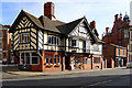
Nearby Images from Geograph Britain and Ireland:

©2012(licence)
©2020(licence)

©2020(licence)
©2011(licence)
©2009(licence)
The above images may not be of the site on this page, they are loaded from Geograph.
Please Submit an Image of this site or go out and take one for us!
Click here to see more info for this site
Nearby sites
Key: Red: member's photo, Blue: 3rd party photo, Yellow: other image, Green: no photo - please go there and take one, Grey: site destroyed
Download sites to:
KML (Google Earth)
GPX (GPS waypoints)
CSV (Garmin/Navman)
CSV (Excel)
To unlock full downloads you need to sign up as a Contributory Member. Otherwise downloads are limited to 50 sites.
Turn off the page maps and other distractions
Nearby sites listing. In the following links * = Image available
307m WSW 250° Roodee Cross, Chester Race Course* Ancient Cross (SJ4017065847)
337m N 10° Chester High Cross* Ancient Cross (SJ4052166282)
341m ENE 69° Roman Garden & Hypocaust (Chester)* Ancient Village or Settlement (SJ4078066070)
349m NNE 18° Edinburgh Woollen Mill Hypocaust* Museum (SJ4057266281)
352m N 6° Dewa Roman Experience* Museum (SJ405663)
361m NE 53° South East Angle Tower of Legionary Fortress* Stone Fort or Dun (SJ4075166165)
399m SSE 148° Chester Minerva shrine* Ancient Temple (SJ40676561)
424m ENE 60° Roman Amphitheatre (Chester)* Ancient Palace (SJ4083066160)
483m ENE 67° St John the Baptist Church, Chester* Ancient Cross (SJ40916613)
502m ENE 76° The Hermitage (Chester)* Ancient Temple (SJ4095066064)
853m ENE 72° Billy Hobby's Well* Holy Well or Sacred Spring (SJ4127766202)
2.1km SSE 165° Heronbridge Roman Strip Settlement Ancient Village or Settlement (SJ410639)
6.7km NE 51° St Plegmund's Well* Holy Well or Sacred Spring (SJ457701)
7.5km S 180° Poulton Timber Circle* Ancient Village or Settlement (SJ4033558472)
8.9km SSW 204° St Peter's Well (Denbighshire) Holy Well or Sacred Spring (SJ36735784)
9.0km NW 304° Modern Stones at Deeside Industrial Area* Modern Stone Circle etc (SJ330711)
9.4km NNE 22° St Mary (Thornton Le Moors)* Ancient Cross (SJ44157455)
9.4km ESE 102° Brookhouse Farm Ancient Village or Settlement (SJ497639)
9.9km S 176° Knowl Plantation Barrow Cemetery (SJ410561)
10.2km S 176° Churton* Long Barrow (SJ411558)
12.1km SW 231° Hope Church Early Medieval Stones* Ancient Cross (SJ310584)
12.4km SSW 207° The Atropos Altar Stone* Sculptured Stone (SJ34645497)
12.4km SW 226° Caer Estyn* Hillfort (SJ314574)
12.6km SW 235° Park in the Past* Museum (SJ301588)
12.6km NW 311° Hampston's Well* Holy Well or Sacred Spring (SJ3099074309)
View more nearby sites and additional images


 We would like to know more about this location. Please feel free to add a brief description and any relevant information in your own language.
 Wir möchten mehr über diese Stätte erfahren. Bitte zögern Sie nicht, eine kurze Beschreibung und relevante Informationen in Deutsch hinzuzufügen.
 Nous aimerions en savoir encore un peu sur les lieux. S'il vous plaît n'hesitez pas à ajouter une courte description et tous les renseignements pertinents dans votre propre langue.
 Quisieramos informarnos un poco más de las lugares. No dude en añadir una breve descripción y otros datos relevantes en su propio idioma.