


<< Text Pages >> Frisby Cross - Ancient Cross in England in Leicestershire and Rutland
Submitted by 05surveyor on Sunday, 04 December 2016 Page Views: 1730
Early MedievalSite Name: Frisby CrossCountry: England County: Leicestershire and Rutland Type: Ancient Cross
Nearest Town: Melton Mowbray Nearest Village: Frisby on the Wreake
Map Ref: SK6942017659
Latitude: 52.752097N Longitude: 0.972921W
Condition:
| 5 | Perfect |
| 4 | Almost Perfect |
| 3 | Reasonable but with some damage |
| 2 | Ruined but still recognisable as an ancient site |
| 1 | Pretty much destroyed, possibly visible as crop marks |
| 0 | No data. |
| -1 | Completely destroyed |
| 5 | Superb |
| 4 | Good |
| 3 | Ordinary |
| 2 | Not Good |
| 1 | Awful |
| 0 | No data. |
| 5 | Can be driven to, probably with disabled access |
| 4 | Short walk on a footpath |
| 3 | Requiring a bit more of a walk |
| 2 | A long walk |
| 1 | In the middle of nowhere, a nightmare to find |
| 0 | No data. |
| 5 | co-ordinates taken by GPS or official recorded co-ordinates |
| 4 | co-ordinates scaled from a detailed map |
| 3 | co-ordinates scaled from a bad map |
| 2 | co-ordinates of the nearest village |
| 1 | co-ordinates of the nearest town |
| 0 | no data |
Internal Links:
External Links:
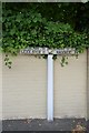
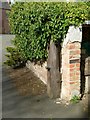
Ancient Cross in Leicestershire and Rutland
Old village cross moved to its present position from its former position in the middle of the road junction (marked by a stone cross in the road)
You may be viewing yesterday's version of this page. To see the most up to date information please register for a free account.
Do not use the above information on other web sites or publications without permission of the contributor.
Nearby Images from Geograph Britain and Ireland:

©2023(licence)
©2019(licence)
©2015(licence)
©2020(licence)
©2015(licence)
The above images may not be of the site on this page, they are loaded from Geograph.
Please Submit an Image of this site or go out and take one for us!
Click here to see more info for this site
Nearby sites
Key: Red: member's photo, Blue: 3rd party photo, Yellow: other image, Green: no photo - please go there and take one, Grey: site destroyed
Download sites to:
KML (Google Earth)
GPX (GPS waypoints)
CSV (Garmin/Navman)
CSV (Excel)
To unlock full downloads you need to sign up as a Contributory Member. Otherwise downloads are limited to 50 sites.
Turn off the page maps and other distractions
Nearby sites listing. In the following links * = Image available
686m SSE 157° Stump Cross (Frisby on the Wreake) Ancient Cross (SK6969917032)
1.9km NE 48° All Saints (Asfordby)* Ancient Cross (SK7081218939)
1.9km NE 46° Asfordby Cross* Ancient Cross (SK7078419006)
2.7km W 263° Hoby Stone Standing Stone (Menhir) (SK667173)
3.6km NNE 22° Saxelbye Stone* Standing Stone (Menhir) (SK707210)
4.0km NW 305° Ragdale Stone* Standing Stone (Menhir) (SK661199)
4.3km NNW 347° Grimston Stone* Standing Stone (Menhir) (SK684218)
4.3km NNW 349° Grimston Church Monolith* Standing Stone (Menhir) (SK685219)
4.5km S 190° The Blue Stone (Gaddesby)* Standing Stone (Menhir) (SK687132)
4.7km SSE 155° Folville Cross* Ancient Cross (SK715134)
5.4km SW 236° Blue Stone (Rearsby)* Natural Stone / Erratic / Other Natural Feature (SK6497414518)
6.0km NNE 30° Ab Kettleby* Holy Well or Sacred Spring (SK724229)
6.2km WSW 237° Rearsby Timber Circle Timber Circle (SK643142)
6.9km SW 217° Queniborough Stones* Standing Stones (SK653121)
7.3km NNE 27° Holwell Mouth* Holy Well or Sacred Spring (SK7269324230)
7.6km E 96° Burton Lazars Stockwell* Holy Well or Sacred Spring (SK770170)
7.9km NNE 18° Clawson Hose and Harby Cursus Cursus (SK718252)
8.0km SW 215° Mowde Bush Stone* Standing Stone (Menhir) (SK649110)
8.7km N 358° Woundheal Spring* Holy Well or Sacred Spring (SK690264)
8.8km NNE 33° Hazeltongue Lodge Henge (SK74092509)
8.8km SE 132° Burrough-on-the-hill* Hillfort (SK761119)
9.8km SSW 199° Beeby Holy Well* Holy Well or Sacred Spring (SK664083)
9.9km NNE 17° Long Clawson Stone* Standing Stone (Menhir) (SK722272)
10.0km SSW 201° Beeby Henge (SK660083)
10.1km WSW 243° Cossington Bronze Age Barrows* Barrow Cemetery (SK605129)
View more nearby sites and additional images


 We would like to know more about this location. Please feel free to add a brief description and any relevant information in your own language.
 Wir möchten mehr über diese Stätte erfahren. Bitte zögern Sie nicht, eine kurze Beschreibung und relevante Informationen in Deutsch hinzuzufügen.
 Nous aimerions en savoir encore un peu sur les lieux. S'il vous plaît n'hesitez pas à ajouter une courte description et tous les renseignements pertinents dans votre propre langue.
 Quisieramos informarnos un poco más de las lugares. No dude en añadir una breve descripción y otros datos relevantes en su propio idioma.