 with our Megalithic Portal iPhone app")

<< Our Photo Pages >> St John the Baptist and St Alkmund (Aymestrey) - Ancient Cross in England in Herefordshire
Submitted by Anne T on Wednesday, 21 July 2021 Page Views: 1911
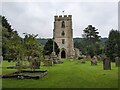
Medieval (High and Late)Site Name: St John the Baptist and St Alkmund (Aymestrey) Alternative Name: Aymestrey ChurchCountry: England County: Herefordshire Type: Ancient Cross
Nearest Town: Leominster Nearest Village: Aymestrey
Map Ref: SO4256065130
Latitude: 52.281297N Longitude: 2.843393W
Condition:
| 5 | Perfect |
| 4 | Almost Perfect |
| 3 | Reasonable but with some damage |
| 2 | Ruined but still recognisable as an ancient site |
| 1 | Pretty much destroyed, possibly visible as crop marks |
| 0 | No data. |
| -1 | Completely destroyed |
| 5 | Superb |
| 4 | Good |
| 3 | Ordinary |
| 2 | Not Good |
| 1 | Awful |
| 0 | No data. |
| 5 | Can be driven to, probably with disabled access |
| 4 | Short walk on a footpath |
| 3 | Requiring a bit more of a walk |
| 2 | A long walk |
| 1 | In the middle of nowhere, a nightmare to find |
| 0 | No data. |
| 5 | co-ordinates taken by GPS or official recorded co-ordinates |
| 4 | co-ordinates scaled from a detailed map |
| 3 | co-ordinates scaled from a bad map |
| 2 | co-ordinates of the nearest village |
| 1 | co-ordinates of the nearest town |
| 0 | no data |
Internal Links:
External Links:
I have visited· I would like to visit
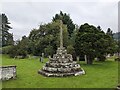
Anne T visited on 9th Jul 2021 - their rating: Cond: 4 Access: 4 Churchyard Cross (Aymestrey): We were here for my son and DIL's wedding rehearsal, but I was also very keen to get out into the churchyard to photograph this cross before dusk fell. Whilst the cross is medieval, Beaker burials have been found nearby, and I'm doing further research on the church to find out if a wooden building might have pre-dated the 12th century church. A very pretty spot, although difficult to find the church car park (the small lane is just to the north of the northern wall of the churchyard), and we missed this, so parked in the village hall and walked back the 150-200m to the church along the (at that time of night) quiet A4110.
 (PID:229285)")
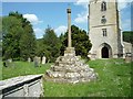
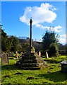
Ref: Monument Number 108434 It is further described as a: "standing stone cross, located within the churchyard of St John the Baptist's and St Alkmund's Church. The cross is 15th century in date with 17th century additions and is scheduled as Historic England List ID 1349736. A second entry for the cross also exists - see Historic England List ID 1016137.
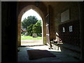
The church itself, listed as Historic England List ID 1082113, dates from the 12th century, although extended in the 14th century, rebuilt in the 16th century and restored in 1884-86. Information boards within the church say that a Beaker burial was found nearby.
Parking is available down a narrow lane just to the north of the north wall of the churchyard. Access to the churchyard is available from the car park, or from the western end of the churchyard, through the lych gate. Visitors need to walk across the grass to the western door into the church. As the entrance to the small church car park is easy to miss, alternate parking is available at the community hall about 150 metres to the south of the church.
You may be viewing yesterday's version of this page. To see the most up to date information please register for a free account.
 (PID:229284)")
 (PID:229283)")
 (PID:229282)")
Do not use the above information on other web sites or publications without permission of the contributor.
Nearby Images from Geograph Britain and Ireland:
©2018(licence)
©2023(licence)
©2015(licence)
©2018(licence)
©2023(licence)
The above images may not be of the site on this page, they are loaded from Geograph.
Please Submit an Image of this site or go out and take one for us!
Click here to see more info for this site
Nearby sites
Key: Red: member's photo, Blue: 3rd party photo, Yellow: other image, Green: no photo - please go there and take one, Grey: site destroyed
Download sites to:
KML (Google Earth)
GPX (GPS waypoints)
CSV (Garmin/Navman)
CSV (Excel)
To unlock full downloads you need to sign up as a Contributory Member. Otherwise downloads are limited to 50 sites.
Turn off the page maps and other distractions
Nearby sites listing. In the following links * = Image available
1.3km N 352° Pyon Wood* Hillfort (SO424664)
2.5km NE 47° Croft Ambrey* Hillfort (SO444668)
3.0km ENE 70° Bircher Common* Misc. Earthwork (SO454661)
4.4km SSE 151° St Michael's Church (Kingsland)* Ancient Cross (SO4468461269)
6.3km ESE 105° Luston Holy Well* Holy Well or Sacred Spring (SO4859563407)
7.7km NNW 341° Brandon Camp* Hillfort (SO401724)
8.4km WSW 251° Wapley Camp* Hillfort (SO3457162465)
9.3km NW 315° Brampton Bryan Lady Well* Holy Well or Sacred Spring (SO36007172)
9.5km W 260° Cat and Fiddle Enclosure Cropmark Ancient Village or Settlement (SO33146362)
9.7km NE 42° Haye Park Wood Enclosure* Ancient Village or Settlement (SO49167229)
10.2km W 269° Stapleton Henge Henge (SO32356510)
10.2km NW 324° Coxall Knoll* Hillfort (SO366734)
10.6km SSW 214° Tank Cottage Standing Stone (Menhir) (SO36615640)
10.6km NNW 343° Leintwardine Cursus Cursus (SO39577534)
11.0km W 266° St Andrew's Church (Presteigne)* Ancient Cross (SO3156864528)
11.9km SSE 150° Ivington Camp* Hillfort (SO484547)
12.8km NE 42° Ludlow Museum* Museum (SO512746)
12.9km WNW 292° Spaceguard Centre* Modern Stone Circle etc (SO3066970104)
13.0km ESE 112° Bach Camp* Hillfort (SO546602)
13.0km NW 326° Castle Ditches (Shropshire)* Ancient Village or Settlement (SO35357594)
13.0km NE 39° Boiling Well (Ludlow)* Holy Well or Sacred Spring (SO508752)
13.6km SW 221° Lyonshall Bank* Misc. Earthwork (SO3349355016)
13.6km NE 42° St Julian's Well (Ludlow)* Holy Well or Sacred Spring (SO5184275060)
13.9km SE 130° Blackwardine Crossroads* Modern Stone Circle etc (SO5318656161)
13.9km S 169° Bush Bank* Standing Stone (Menhir) (SO4496251449)
View more nearby sites and additional images


 We would like to know more about this location. Please feel free to add a brief description and any relevant information in your own language.
 Wir möchten mehr über diese Stätte erfahren. Bitte zögern Sie nicht, eine kurze Beschreibung und relevante Informationen in Deutsch hinzuzufügen.
 Nous aimerions en savoir encore un peu sur les lieux. S'il vous plaît n'hesitez pas à ajouter une courte description et tous les renseignements pertinents dans votre propre langue.
 Quisieramos informarnos un poco más de las lugares. No dude en añadir una breve descripción y otros datos relevantes en su propio idioma.