


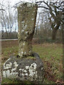
<< Our Photo Pages >> Gattle's Cross - Marker Stone in England in Gloucestershire
Submitted by 4clydesdale7 on Tuesday, 15 May 2012 Page Views: 6719
Multi-periodSite Name: Gattle's Cross Alternative Name: Cradock's Stone, Caradoc's Stone, Milo's CrossCountry: England County: Gloucestershire Type: Marker Stone
Nearest Town: Coleford Nearest Village: Clearwell Meend; Sling
Map Ref: SO5812608512
Latitude: 51.773703N Longitude: 2.60829W
Condition:
| 5 | Perfect |
| 4 | Almost Perfect |
| 3 | Reasonable but with some damage |
| 2 | Ruined but still recognisable as an ancient site |
| 1 | Pretty much destroyed, possibly visible as crop marks |
| 0 | No data. |
| -1 | Completely destroyed |
| 5 | Superb |
| 4 | Good |
| 3 | Ordinary |
| 2 | Not Good |
| 1 | Awful |
| 0 | No data. |
| 5 | Can be driven to, probably with disabled access |
| 4 | Short walk on a footpath |
| 3 | Requiring a bit more of a walk |
| 2 | A long walk |
| 1 | In the middle of nowhere, a nightmare to find |
| 0 | No data. |
| 5 | co-ordinates taken by GPS or official recorded co-ordinates |
| 4 | co-ordinates scaled from a detailed map |
| 3 | co-ordinates scaled from a bad map |
| 2 | co-ordinates of the nearest village |
| 1 | co-ordinates of the nearest town |
| 0 | no data |
Internal Links:
External Links:
I have visited· I would like to visit
Mura would like to visit
4clydesdale7 visited on 14th May 2012 - their rating: Cond: 3 Amb: 4 Access: 5 Most unusual - nice bit of folklore - Is it an upturned Cross? Almost certainly
Geojazz have visited here
")
The original Stone may have commemorated an ancient burial AND it is reputedly haunted by the ghost of a Forest of Dean miner dressed in black
The Stone lies 20m east of the Coleford to St Briavels B4228 south of the football field at Clearwell Meend - quite easy to find
Read More at Pastscape, Monument Number 109396.
You may be viewing yesterday's version of this page. To see the most up to date information please register for a free account.
")
Do not use the above information on other web sites or publications without permission of the contributor.
TimPrevett has found this location on Google Street View:
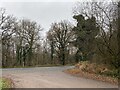
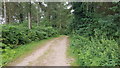
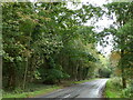
Nearby Images from Geograph Britain and Ireland:
©2022(licence)
©2021(licence)
©2019(licence)

©2025(licence)
©2023(licence)
The above images may not be of the site on this page, they are loaded from Geograph.
Please Submit an Image of this site or go out and take one for us!
Click here to see more info for this site
Nearby sites
Key: Red: member's photo, Blue: 3rd party photo, Yellow: other image, Green: no photo - please go there and take one, Grey: site destroyed
Download sites to:
KML (Google Earth)
GPX (GPS waypoints)
CSV (Garmin/Navman)
CSV (Excel)
To unlock full downloads you need to sign up as a Contributory Member. Otherwise downloads are limited to 50 sites.
Turn off the page maps and other distractions
Nearby sites listing. In the following links * = Image available
515m SW 235° Clearwell Caves* Ancient Mine, Quarry or other Industry (SO57700822)
2.7km SW 219° Stowe Enclosure* Misc. Earthwork (SO56430643)
3.0km WNW 289° Newland Crosses* Ancient Cross (SO5530809511)
4.2km NNW 328° Long Stone, Staunton* Standing Stone (Menhir) (SO55931206)
4.5km SSW 208° St Briavels Cross Slab* Early Christian Sculptured Stone (SO5592504540)
4.6km SSW 210° St Bride's Well* Holy Well or Sacred Spring (SO5574404515)
4.7km SSW 207° The Ancient Barrow Well, St. Briavel's* Holy Well or Sacred Spring (SO5593004337)
5.1km NW 323° Staunton Cross* Ancient Cross (SO5506412571)
5.1km NW 319° Brindsey Well* Holy Well or Sacred Spring (SO5481712403)
5.3km NE 47° The Speech Stone* Marker Stone (SO62011212)
5.4km NW 313° The Virgins Cup* Natural Stone / Erratic / Other Natural Feature (SO54191219)
5.4km NW 319° Toads Mouth Stone* Natural Stone / Erratic / Other Natural Feature (SO54621260)
5.4km NW 320° John The Baptists Well (Staunton)* Holy Well or Sacred Spring (SO5467512722)
5.5km NW 312° The Buck Stone (Gloucestershire)* Rock Outcrop (SO541122)
5.9km NW 311° Staunton Broadstones* Natural Stone / Erratic / Other Natural Feature (SO53741242)
5.9km NW 324° Calfs Well* Holy Well or Sacred Spring (SO5465613283)
6.3km NNW 332° Whipping Brook Cave Cave or Rock Shelter (SO55251410)
6.3km WNW 290° Penallt Churchyard Cross* Ancient Cross (SO5220010720)
6.6km W 279° Peny Garn Cross Base* Ancient Cross (SO5158909643)
6.6km NNW 333° The Biblins Cave Cave or Rock Shelter (SO55161446)
6.7km NW 325° Near Hearkening Rock* Natural Stone / Erratic / Other Natural Feature (SO54311401)
6.7km NW 324° Staunton Suck Stone (Gloucestershire)* Natural Stone / Erratic / Other Natural Feature (SO54211401)
6.8km SSE 149° Lydney Hillfort* Hillfort (SO6160002700)
7.0km NNW 338° Lord's Wood Cave Cave or Rock Shelter (SO55551503)
7.0km NNW 337° Biblins Cave or Rock Shelter (SO554150)
View more nearby sites and additional images


 We would like to know more about this location. Please feel free to add a brief description and any relevant information in your own language.
 Wir möchten mehr über diese Stätte erfahren. Bitte zögern Sie nicht, eine kurze Beschreibung und relevante Informationen in Deutsch hinzuzufügen.
 Nous aimerions en savoir encore un peu sur les lieux. S'il vous plaît n'hesitez pas à ajouter une courte description et tous les renseignements pertinents dans votre propre langue.
 Quisieramos informarnos un poco más de las lugares. No dude en añadir una breve descripción y otros datos relevantes en su propio idioma.