 with our Megalithic Portal iPhone app")


<< Our Photo Pages >> Bewells Cross - Ancient Cross in England in Gloucestershire
Submitted by dooclay on Sunday, 03 November 2024 Page Views: 858
Early MedievalSite Name: Bewells CrossCountry: England
NOTE: This site is 0.7 km away from the location you searched for.
County: Gloucestershire Type: Ancient Cross
Nearest Town: Bristol
Map Ref: ST5822673871
Latitude: 51.462261N Longitude: 2.602699W
Condition:
| 5 | Perfect |
| 4 | Almost Perfect |
| 3 | Reasonable but with some damage |
| 2 | Ruined but still recognisable as an ancient site |
| 1 | Pretty much destroyed, possibly visible as crop marks |
| 0 | No data. |
| -1 | Completely destroyed |
| 5 | Superb |
| 4 | Good |
| 3 | Ordinary |
| 2 | Not Good |
| 1 | Awful |
| 0 | No data. |
| 5 | Can be driven to, probably with disabled access |
| 4 | Short walk on a footpath |
| 3 | Requiring a bit more of a walk |
| 2 | A long walk |
| 1 | In the middle of nowhere, a nightmare to find |
| 0 | No data. |
| 5 | co-ordinates taken by GPS or official recorded co-ordinates |
| 4 | co-ordinates scaled from a detailed map |
| 3 | co-ordinates scaled from a bad map |
| 2 | co-ordinates of the nearest village |
| 1 | co-ordinates of the nearest town |
| 0 | no data |
Internal Links:
External Links:
")
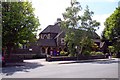
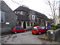
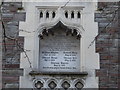
Built into the boundary wall of Cotham Parish is a block of stone that some claim to be the remains of the Medieval Bewells Cross. A plaque is situated above giving details. The origins of the stone are disputed however w/ some claiming that it is not in the right location.
You may be viewing yesterday's version of this page. To see the most up to date information please register for a free account.
Do not use the above information on other web sites or publications without permission of the contributor.
Nearby Images from Geograph Britain and Ireland:
©2011(licence)
©2018(licence)
©2018(licence)

©2025(licence)
©2010(licence)
The above images may not be of the site on this page, they are loaded from Geograph.
Please Submit an Image of this site or go out and take one for us!
Click here to see more info for this site
Nearby sites
Key: Red: member's photo, Blue: 3rd party photo, Yellow: other image, Green: no photo - please go there and take one, Grey: site destroyed
Download sites to:
KML (Google Earth)
GPX (GPS waypoints)
CSV (Garmin/Navman)
CSV (Excel)
To unlock full downloads you need to sign up as a Contributory Member. Otherwise downloads are limited to 50 sites.
Turn off the page maps and other distractions
Nearby sites listing. In the following links * = Image available
684m SSW 194° Bristol City Museum* Museum (ST58057321)
1.1km NNW 344° Redland Park* Standing Stone (Menhir) (ST57947492)
1.7km WSW 250° Clifton Down Camp* Hillfort (ST56587329)
2.0km E 90° Armoury Square Standing Stone (Menhir) (ST60287386)
2.2km WSW 246° Burwalls Camp* Promontory Fort / Cliff Castle (ST562730)
2.3km WSW 255° Stokeleigh Camp* Promontory Fort / Cliff Castle (ST560733)
3.1km NW 317° Druid Stoke* Chambered Tomb (ST56107620)
3.8km W 272° Abbots Leigh Churchyard Cross* Ancient Cross (ST5445274007)
4.0km N 356° Southmead Barrow* Round Barrow(s) (ST5794477902)
4.1km E 93° Don Johns Cross* Ancient Cross (ST6229873640)
4.1km SW 223° Long Ashton Cross* Ancient Cross (ST5539070910)
4.2km ESE 109° St Ann's Well (Brislington)* Holy Well or Sacred Spring (ST6217472515)
4.6km NE 42° Stoke Park Long Barrow* Long Barrow (ST6132077294)
5.0km W 260° Snake's Well and Spring* Holy Well or Sacred Spring (ST53287308)
5.0km NNW 328° King's Weston Hillfort* Hillfort (ST55597813)
5.1km NW 326° King's Weston Hill stockpound* Misc. Earthwork (ST55417807)
5.1km NNW 332° Blaise Castle* Hillfort (ST55857837)
5.1km NW 322° King's Weston Hill barrow cemetary* Barrow Cemetery (ST55127793)
5.3km NW 313° Bewys Cross* Ancient Cross (ST5436877571)
5.9km ENE 59° Oldbury Court Camp Ancient Village or Settlement (ST633769)
6.5km WSW 252° Wraxall Camp* Ancient Village or Settlement (ST52057193)
7.1km N 8° Highwood Road Modern Menhir* Modern Stone Circle etc (ST5928080878)
7.3km SW 223° Fairy Well (Barrow Gurney) Holy Well or Sacred Spring (ST532686)
7.4km S 184° Dundry Long Barrow* Long Barrow (ST57606645)
8.1km SSE 167° Maes Knoll* Hillfort (ST600660)
View more nearby sites and additional images


 We would like to know more about this location. Please feel free to add a brief description and any relevant information in your own language.
 Wir möchten mehr über diese Stätte erfahren. Bitte zögern Sie nicht, eine kurze Beschreibung und relevante Informationen in Deutsch hinzuzufügen.
 Nous aimerions en savoir encore un peu sur les lieux. S'il vous plaît n'hesitez pas à ajouter une courte description et tous les renseignements pertinents dans votre propre langue.
 Quisieramos informarnos un poco más de las lugares. No dude en añadir una breve descripción y otros datos relevantes en su propio idioma.