


<< Text Pages >> Sully Island Promontory Fort - Promontory Fort / Cliff Castle in Wales in South Glamorgan
Submitted by coldrum on Saturday, 02 July 2011 Page Views: 5434
Iron Age and Later PrehistorySite Name: Sully Island Promontory FortCountry: Wales County: South Glamorgan Type: Promontory Fort / Cliff Castle
Nearest Town: Barry
Map Ref: ST16876697
Latitude: 51.395652N Longitude: 3.196264W
Condition:
| 5 | Perfect |
| 4 | Almost Perfect |
| 3 | Reasonable but with some damage |
| 2 | Ruined but still recognisable as an ancient site |
| 1 | Pretty much destroyed, possibly visible as crop marks |
| 0 | No data. |
| -1 | Completely destroyed |
| 5 | Superb |
| 4 | Good |
| 3 | Ordinary |
| 2 | Not Good |
| 1 | Awful |
| 0 | No data. |
| 5 | Can be driven to, probably with disabled access |
| 4 | Short walk on a footpath |
| 3 | Requiring a bit more of a walk |
| 2 | A long walk |
| 1 | In the middle of nowhere, a nightmare to find |
| 0 | No data. |
| 5 | co-ordinates taken by GPS or official recorded co-ordinates |
| 4 | co-ordinates scaled from a detailed map |
| 3 | co-ordinates scaled from a bad map |
| 2 | co-ordinates of the nearest village |
| 1 | co-ordinates of the nearest town |
| 0 | no data |
Internal Links:
External Links:
I have visited· I would like to visit
Baruc visited on 1st Aug 1979 - their rating: Cond: 2 Amb: 3 Access: 3
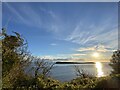
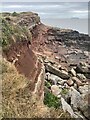
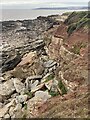
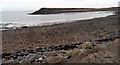
The east end of Sully Island is defended by a succession of three ramparts. There has been erosion, particularly on the south, and the north half is thickly overgrown; the present area of the main enclosure is about 0.4 ha, but it may originally have been twice as much. The inner rampart, cutting off the subsidiary promontory at the point of contraction, was fronted by a ditch and is thought to have been revetted, or walled in stone.
Source: Coflein
You may be viewing yesterday's version of this page. To see the most up to date information please register for a free account.
Do not use the above information on other web sites or publications without permission of the contributor.
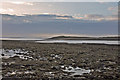
Nearby Images from Geograph Britain and Ireland:
©2021(licence)
©2022(licence)
©2022(licence)
©2012(licence)
©2009(licence)
The above images may not be of the site on this page, they are loaded from Geograph.
Please Submit an Image of this site or go out and take one for us!
Click here to see more info for this site
Nearby sites
Key: Red: member's photo, Blue: 3rd party photo, Yellow: other image, Green: no photo - please go there and take one, Grey: site destroyed
Download sites to:
KML (Google Earth)
GPX (GPS waypoints)
CSV (Garmin/Navman)
CSV (Excel)
To unlock full downloads you need to sign up as a Contributory Member. Otherwise downloads are limited to 50 sites.
Turn off the page maps and other distractions
Nearby sites listing. In the following links * = Image available
78m SE 129° Sully Island Mound Round Barrow(s) (ST16936692)
1.3km NE 45° St Marys Well Holy Well or Sacred Spring (ST17796785)
4.9km W 263° St Barruc's Holy Well (Barry Island)* Holy Well or Sacred Spring (ST12006643)
5.3km ESE 111° Flatholm glacial erratic* Natural Stone / Erratic / Other Natural Feature (ST21826496)
5.4km NW 305° Pencoetre Wood Barrow Round Barrow(s) (ST125701)
5.9km W 259° Barry Island Cairns* Cairn (ST11076598)
6.6km W 261° Cold Knap Round Barrow* Cairn (ST10306607)
6.7km W 270° Barry Gorsedd Circle* Modern Stone Circle etc (ST1018967130)
7.0km NNW 334° Cwrt-yr-ala Hillfort (ST139733)
7.7km NNW 348° Leckwith Round Barrow(s) (ST154745)
7.7km W 269° Westward Corner Round Barrow* Round Barrow(s) (ST0916266901)
7.7km NW 309° Goldsland Wood Cave Cave or Rock Shelter (ST109719)
7.9km NNW 332° Coed-y Cymdda Hillfort (ST13297398)
8.0km NNE 16° Roundstone Wood* Modern Stone Circle etc (ST192746)
8.5km NW 320° Quarrymen Stone* Modern Stone Circle etc (ST115736)
8.5km W 271° Lower Porthkerry House Platform Ancient Village or Settlement (ST083672)
8.6km NW 307° St Lythans* Chambered Tomb (ST10097230)
8.6km NW 318° Marsyd Round Barrow(s) (ST11217352)
8.7km NNW 336° Caerau (Cardiff)* Hillfort (ST1337074980)
8.9km NNW 332° Trelai Park Timber Circle and Burials* Timber Circle (ST1277174929)
9.1km NW 317° St Lythans Down Round Barrow* Round Barrow(s) (ST10717367)
9.3km NW 318° Vianshill Round Barrow(s) (ST10717401)
9.6km N 5° Gorsedd Circle (Bute Park)* Modern Stone Circle etc (ST178765)
9.8km NW 309° Tinkinswood 2* Burial Chamber or Dolmen (ST09337327)
9.8km NW 309° Tinkinswood quarry* Ancient Mine, Quarry or other Industry (ST09337331)
View more nearby sites and additional images


 We would like to know more about this location. Please feel free to add a brief description and any relevant information in your own language.
 Wir möchten mehr über diese Stätte erfahren. Bitte zögern Sie nicht, eine kurze Beschreibung und relevante Informationen in Deutsch hinzuzufügen.
 Nous aimerions en savoir encore un peu sur les lieux. S'il vous plaît n'hesitez pas à ajouter une courte description et tous les renseignements pertinents dans votre propre langue.
 Quisieramos informarnos un poco más de las lugares. No dude en añadir una breve descripción y otros datos relevantes en su propio idioma.