

<< Text Pages >> Friar Waddon Hill - Barrow Cemetery in England in Dorset
Submitted by TimPrevett on Monday, 23 May 2005 Page Views: 8826
Neolithic and Bronze AgeSite Name: Friar Waddon HillCountry: England
NOTE: This site is 0.353 km away from the location you searched for.
County: Dorset Type: Barrow Cemetery
Nearest Town: Dorchester Nearest Village: Upwey
Map Ref: SY641855
Latitude: 50.668053N Longitude: 2.50935W
Condition:
| 5 | Perfect |
| 4 | Almost Perfect |
| 3 | Reasonable but with some damage |
| 2 | Ruined but still recognisable as an ancient site |
| 1 | Pretty much destroyed, possibly visible as crop marks |
| 0 | No data. |
| -1 | Completely destroyed |
| 5 | Superb |
| 4 | Good |
| 3 | Ordinary |
| 2 | Not Good |
| 1 | Awful |
| 0 | No data. |
| 5 | Can be driven to, probably with disabled access |
| 4 | Short walk on a footpath |
| 3 | Requiring a bit more of a walk |
| 2 | A long walk |
| 1 | In the middle of nowhere, a nightmare to find |
| 0 | No data. |
| 5 | co-ordinates taken by GPS or official recorded co-ordinates |
| 4 | co-ordinates scaled from a detailed map |
| 3 | co-ordinates scaled from a bad map |
| 2 | co-ordinates of the nearest village |
| 1 | co-ordinates of the nearest town |
| 0 | no data |
Internal Links:
External Links:
Barrow Cemetery in Dorset
You may be viewing yesterday's version of this page. To see the most up to date information please register for a free account.
Do not use the above information on other web sites or publications without permission of the contributor.
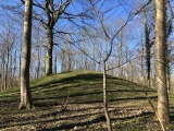
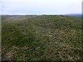
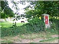
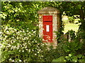
Nearby Images from Geograph Britain and Ireland:
©2015(licence)
©2009(licence)
©2010(licence)
©2007(licence)
©2007(licence)
The above images may not be of the site on this page, they are loaded from Geograph.
Please Submit an Image of this site or go out and take one for us!
Click here to see more info for this site
Nearby sites
Key: Red: member's photo, Blue: 3rd party photo, Yellow: other image, Green: no photo - please go there and take one, Grey: site destroyed
Download sites to:
KML (Google Earth)
GPX (GPS waypoints)
CSV (Garmin/Navman)
CSV (Excel)
To unlock full downloads you need to sign up as a Contributory Member. Otherwise downloads are limited to 50 sites.
Turn off the page maps and other distractions
Nearby sites listing. In the following links * = Image available
1.3km NNW 347° Great Hill (Martinstown)* Barrow Cemetery (SY638868)
1.4km NNE 30° Ridge Hill* Barrow Cemetery (SY648867)
2.0km NW 314° Bronkham Hill* Barrow Cemetery (SY6267086880)
2.0km E 98° Upwey Wishing Well* Holy Well or Sacred Spring (SY661852)
2.2km NNE 18° Eweleaze Barn* Barrow Cemetery (SY648876)
2.3km W 277° Waddon Henge Henge (SY6185085783)
2.4km ENE 63° Upwey Ridgeway* Barrow Cemetery (SY66298659)
2.6km NE 49° Ashton Farm Bowl Barrows Barrow Cemetery (SY66088717)
2.7km NNE 21° Four Barrow Hill* Round Barrow(s) (SY651880)
2.8km WNW 295° Portesham Stone 6 Standing Stone (Menhir) (SY616867)
3.1km E 84° Ridgeway Hill* Barrow Cemetery (SY672858)
3.3km NW 312° Smitten Corner* Barrow Cemetery (SY617877)
3.4km WNW 290° Portesham Stone 5 Standing Stone (Menhir) (SY609867)
3.4km WNW 292° Portesham Stone 10* Standing Stone (Menhir) (SY609868)
3.5km WNW 293° Portesham Stone 4* Standing Stone (Menhir) (SY609869)
3.5km NW 307° Hardy Monument Barrows* Barrow Cemetery (SY61308760)
3.5km WNW 291° Portesham Stone 3* Standing Stone (Menhir) (SY608868)
3.6km WNW 288° Portesham Stone 12 Standing Stone (Menhir) (SY607866)
3.6km WNW 289° Portesham Stone 11 Standing Stone (Menhir) (SY607867)
3.7km WNW 296° Portesham Stone Row* Stone Row / Alignment (SY608871)
3.7km WNW 293° Portesham Stone 2* Standing Stone (Menhir) (SY607870)
3.7km WNW 288° Hellstone* Long Barrow (SY60588670)
3.7km WNW 294° Jeffrey & Joan (Portesham) Standing Stones (SY60708701)
3.8km E 87° Bincombe Down* Barrow Cemetery (SY679857)
3.8km WNW 293° Portesham Stone 1 Standing Stone (Menhir) (SY606870)
View more nearby sites and additional images


 We would like to know more about this location. Please feel free to add a brief description and any relevant information in your own language.
 Wir möchten mehr über diese Stätte erfahren. Bitte zögern Sie nicht, eine kurze Beschreibung und relevante Informationen in Deutsch hinzuzufügen.
 Nous aimerions en savoir encore un peu sur les lieux. S'il vous plaît n'hesitez pas à ajouter une courte description et tous les renseignements pertinents dans votre propre langue.
 Quisieramos informarnos un poco más de las lugares. No dude en añadir una breve descripción y otros datos relevantes en su propio idioma.