


<< Our Photo Pages >> Wenmouth Cross - Ancient Cross in England in Cornwall
Submitted by dooclay on Monday, 02 December 2024 Page Views: 641
Early MedievalSite Name: Wenmouth CrossCountry: England
NOTE: This site is 3.024 km away from the location you searched for.
County: Cornwall Type: Ancient Cross
Nearest Village: St Neot
Map Ref: SX19656786
Latitude: 50.482733N Longitude: 4.543482W
Condition:
| 5 | Perfect |
| 4 | Almost Perfect |
| 3 | Reasonable but with some damage |
| 2 | Ruined but still recognisable as an ancient site |
| 1 | Pretty much destroyed, possibly visible as crop marks |
| 0 | No data. |
| -1 | Completely destroyed |
| 5 | Superb |
| 4 | Good |
| 3 | Ordinary |
| 2 | Not Good |
| 1 | Awful |
| 0 | No data. |
| 5 | Can be driven to, probably with disabled access |
| 4 | Short walk on a footpath |
| 3 | Requiring a bit more of a walk |
| 2 | A long walk |
| 1 | In the middle of nowhere, a nightmare to find |
| 0 | No data. |
| 5 | co-ordinates taken by GPS or official recorded co-ordinates |
| 4 | co-ordinates scaled from a detailed map |
| 3 | co-ordinates scaled from a bad map |
| 2 | co-ordinates of the nearest village |
| 1 | co-ordinates of the nearest town |
| 0 | no data |
Internal Links:
External Links:
I have visited· I would like to visit
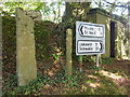
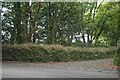
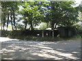
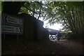
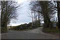
TheCaptain visited on 20th Jun 2025 - their rating: Cond: 3 Amb: 3 Access: 5 Heading south from Colliford Lake, I stop for a look at Wenmouth Cross. It stands at a shady spot by a road junction, its upper arms broken.
")
Source: Cornwall HER, A mutilated latin cross at the Wenmouth cross roads is said to have been restored to its original site in 1932 by Liskeard Old Cornwall Society. It is set in a base which exactly fits the shaft, which was found in a roadside hedge on Tremorkin Farm (17142.02). Prior to 1932, the shaft had served as a gatepost on the NE side of Lampen Lane (17142.01) where it was recorded by Langdon.
You may be viewing yesterday's version of this page. To see the most up to date information please register for a free account.
")
")
Do not use the above information on other web sites or publications without permission of the contributor.
Nearby Images from Geograph Britain and Ireland:
©2019(licence)
©2023(licence)
©2008(licence)
©2023(licence)
©2013(licence)
The above images may not be of the site on this page, they are loaded from Geograph.
Please Submit an Image of this site or go out and take one for us!
Click here to see more info for this site
Nearby sites
Key: Red: member's photo, Blue: 3rd party photo, Yellow: other image, Green: no photo - please go there and take one, Grey: site destroyed
Download sites to:
KML (Google Earth)
GPX (GPS waypoints)
CSV (Garmin/Navman)
CSV (Excel)
To unlock full downloads you need to sign up as a Contributory Member. Otherwise downloads are limited to 50 sites.
Turn off the page maps and other distractions
Nearby sites listing. In the following links * = Image available
1.0km N 1° Berry Castle (St Neot)* Ancient Village or Settlement (SX197689)
1.1km W 267° St Neot Crosses* Ancient Cross (SX1859567843)
1.4km WNW 294° Hilltown Cross* Ancient Cross (SX18426845)
1.4km W 278° St Neot's Well (St Neot)* Holy Well or Sacred Spring (SX183681)
1.7km N 7° Berry Down menhir Standing Stone (Menhir) (SX199695)
1.8km N 3° Mutton Downs Menhir* Standing Stone (Menhir) (SX198697)
2.2km W 265° Crowpound Menhir* Standing Stone (Menhir) (SX17446773)
2.6km NW 319° Trebinnick menhir* Standing Stone (Menhir) (SX180699)
3.4km NW 315° Letter Moor Ringcairn* Ring Cairn (SX17327031)
4.1km NNE 30° Lamelgate Settlement Ancient Village or Settlement (SX21807130)
4.1km ENE 74° King Doniert's Stone* Ancient Cross (SX23626885)
4.1km NNW 327° Searle’s Down* Stone Row / Alignment (SX17547136)
4.3km SW 218° Largin Castle Hillfort (SX16896454)
4.4km N 349° Bunning's Park Earthwork* Ancient Village or Settlement (SX18977218)
5.0km E 85° Church of St Clarus* Early Christian Sculptured Stone (SX247681)
5.0km N 1° Browngelly Downs* Ancient Village or Settlement (SX199729)
5.1km WNW 303° Carburrow Tor cairns* Barrow Cemetery (SX155708)
5.1km NW 304° Carburrow propped stone* Natural Stone / Erratic / Other Natural Feature (SX1549170849)
5.3km E 83° St Cleer's Well* Holy Well or Sacred Spring (SX249683)
5.3km E 83° St Cleer Well Cross* Ancient Cross (SX249683)
5.3km SSW 205° Middle Taphouse Round Barrow (A)* Round Barrow(s) (SX172631)
5.4km NE 50° Tregarrick menhir* Standing Stone (Menhir) (SX23917116)
5.4km NE 53° Tregarrick South Settlement Ancient Village or Settlement (SX24107093)
5.4km NE 48° Tregarrick North Settlement Ancient Village or Settlement (SX23807136)
5.4km NNE 25° Carkeet Downs Settlement Ancient Village or Settlement (SX22167270)
View more nearby sites and additional images


 We would like to know more about this location. Please feel free to add a brief description and any relevant information in your own language.
 Wir möchten mehr über diese Stätte erfahren. Bitte zögern Sie nicht, eine kurze Beschreibung und relevante Informationen in Deutsch hinzuzufügen.
 Nous aimerions en savoir encore un peu sur les lieux. S'il vous plaît n'hesitez pas à ajouter une courte description et tous les renseignements pertinents dans votre propre langue.
 Quisieramos informarnos un poco más de las lugares. No dude en añadir una breve descripción y otros datos relevantes en su propio idioma.