<< Our Photo Pages >> Pierre du Lit - Natural Stone / Erratic / Other Natural Feature in France in Auvergne:Puy-de-Dôme (63)
Submitted by tone on Saturday, 13 August 2011 Page Views: 3035
Natural PlacesSite Name: Pierre du LitCountry: France
NOTE: This site is 1.323 km away from the location you searched for.
Département: Auvergne:Puy-de-Dôme (63) Type: Natural Stone / Erratic / Other Natural Feature
Nearest Town: Ambert Nearest Village: Fournols
Latitude: 45.526700N Longitude: 3.574200E
Condition:
| 5 | Perfect |
| 4 | Almost Perfect |
| 3 | Reasonable but with some damage |
| 2 | Ruined but still recognisable as an ancient site |
| 1 | Pretty much destroyed, possibly visible as crop marks |
| 0 | No data. |
| -1 | Completely destroyed |
| 5 | Superb |
| 4 | Good |
| 3 | Ordinary |
| 2 | Not Good |
| 1 | Awful |
| 0 | No data. |
| 5 | Can be driven to, probably with disabled access |
| 4 | Short walk on a footpath |
| 3 | Requiring a bit more of a walk |
| 2 | A long walk |
| 1 | In the middle of nowhere, a nightmare to find |
| 0 | No data. |
| 5 | co-ordinates taken by GPS or official recorded co-ordinates |
| 4 | co-ordinates scaled from a detailed map |
| 3 | co-ordinates scaled from a bad map |
| 2 | co-ordinates of the nearest village |
| 1 | co-ordinates of the nearest town |
| 0 | no data |
Internal Links:
External Links:
")
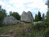
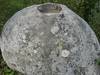
Park on the road opposite the track and walk into the wood 1/3 of a mile and then turn right. It has a sign post and you can't miss it.
Behind it is an opening through the trees. This is walled and there is another large stone you can see but I think it is just a big stone probably chipped away at to get the stone for the wall.
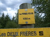
I found Les Deux Frere by accident and there was no sign or name connected to it but I called it that as that was the name of another hamlet nearby and when you see it I think you might think the same. If you know different please let me know or amend accordingly.
You may be viewing yesterday's version of this page. To see the most up to date information please register for a free account.
")
Do not use the above information on other web sites or publications without permission of the contributor.
Nearby Images from Flickr
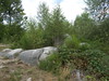
The above images may not be of the site on this page, but were taken nearby. They are loaded from Flickr so please click on them for image credits.
Click here to see more info for this site
Nearby sites
Click here to view sites on an interactive map of the areaKey: Red: member's photo, Blue: 3rd party photo, Yellow: other image, Green: no photo - please go there and take one, Grey: site destroyed
Download sites to:
KML (Google Earth)
GPX (GPS waypoints)
CSV (Garmin/Navman)
CSV (Excel)
To unlock full downloads you need to sign up as a Contributory Member. Otherwise downloads are limited to 50 sites.
Turn off the page maps and other distractions
Nearby sites listing. In the following links * = Image available
140m WNW 304° Pierres Folles (Fournols)* Natural Stone / Erratic / Other Natural Feature
5.4km ESE 116° Pierre de Gargantua (Chambon-sur-Dolore) Rock Art
7.8km SSW 198° Petit monolithe discuté Standing Stone (Menhir)
9.1km SSW 213° Menhir de la Pierre aux Prades Standing Stone (Menhir)
10.3km ENE 78° Pierre Couverte d'Ambert* Burial Chamber or Dolmen
19.0km NE 51° Dolmen de Pierre Cuberte* Burial Chamber or Dolmen
20.6km SE 140° Pierre Couverte (Chassouneyre) Burial Chamber or Dolmen
22.5km SE 127° Triaille Dolmen Burial Chamber or Dolmen
24.0km NE 43° Menhir du Col du Béal Standing Stone (Menhir)
24.5km W 267° Dolmen de Loubaresse* Burial Chamber or Dolmen
25.8km NNE 26° La Renaudie menhir Standing Stone (Menhir)
26.4km SE 139° Dolmen des Fades* Burial Chamber or Dolmen
26.7km SE 135° Pierre des Soeurs Standing Stone (Menhir)
27.2km SE 137° Pierre Plantée des Fades* Standing Stone (Menhir)
27.2km WSW 254° Dolmen de Tablou Natural Stone / Erratic / Other Natural Feature
28.5km NW 320° Pierre-aux-Fées Rock Art
29.4km W 275° Grottes de Perrier* Cave or Rock Shelter
29.5km WSW 250° Collanges menhir Standing Stone (Menhir)
30.7km NNE 17° Barque des Morts Rock Art
30.8km E 86° Dolmen de la Roche-des-Fades Burial Chamber or Dolmen
30.9km WSW 259° Allée Couverte de Villeneuve Passage Grave
31.4km WSW 246° L'Usteau du Loup* Passage Grave
32.8km SSW 199° Dolmen des Quatre Roches Burial Chamber or Dolmen
33.2km N 1° Rocher de l'Aigle Rock Art
33.2km N 1° Pierre des Mousquetaires Rock Art
View more nearby sites and additional images


 We would like to know more about this location. Please feel free to add a brief description and any relevant information in your own language.
 Wir möchten mehr über diese Stätte erfahren. Bitte zögern Sie nicht, eine kurze Beschreibung und relevante Informationen in Deutsch hinzuzufügen.
 Nous aimerions en savoir encore un peu sur les lieux. S'il vous plaît n'hesitez pas à ajouter une courte description et tous les renseignements pertinents dans votre propre langue.
 Quisieramos informarnos un poco más de las lugares. No dude en añadir una breve descripción y otros datos relevantes en su propio idioma.