<< Text Pages >> Lilbourn Mound - Ancient Village or Settlement in United States in The Plains
Submitted by davidmorgan on Saturday, 30 August 2014 Page Views: 2860
Multi-periodSite Name: Lilbourn Mound Alternative Name: 23NM49Country: United States Region: The Plains Type: Ancient Village or Settlement
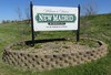
Nearest Town: New Madrid
Latitude: 36.571944N Longitude: 89.58825W
Condition:
| 5 | Perfect |
| 4 | Almost Perfect |
| 3 | Reasonable but with some damage |
| 2 | Ruined but still recognisable as an ancient site |
| 1 | Pretty much destroyed, possibly visible as crop marks |
| 0 | No data. |
| -1 | Completely destroyed |
| 5 | Superb |
| 4 | Good |
| 3 | Ordinary |
| 2 | Not Good |
| 1 | Awful |
| 0 | No data. |
| 5 | Can be driven to, probably with disabled access |
| 4 | Short walk on a footpath |
| 3 | Requiring a bit more of a walk |
| 2 | A long walk |
| 1 | In the middle of nowhere, a nightmare to find |
| 0 | No data. |
| 5 | co-ordinates taken by GPS or official recorded co-ordinates |
| 4 | co-ordinates scaled from a detailed map |
| 3 | co-ordinates scaled from a bad map |
| 2 | co-ordinates of the nearest village |
| 1 | co-ordinates of the nearest town |
| 0 | no data |
Internal Links:
External Links:
Ancient Village or Settlement in New Madrid County, Missouri
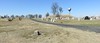
Lilbourn Mound was originally the centre of a palisaded town with smaller mounds and a plaza dating from 1260-1440 CE.
More information at Professor Michael J. Fuller's rescue blog.
You may be viewing yesterday's version of this page. To see the most up to date information please register for a free account.
")
")
Do not use the above information on other web sites or publications without permission of the contributor.
davidmorgan has found this location on Google Street View:
Nearby Images from Flickr


The above images may not be of the site on this page, but were taken nearby. They are loaded from Flickr so please click on them for image credits.
Click here to see more info for this site
Nearby sites
Click here to view sites on an interactive map of the areaKey: Red: member's photo, Blue: 3rd party photo, Yellow: other image, Green: no photo - please go there and take one, Grey: site destroyed
Download sites to:
KML (Google Earth)
GPX (GPS waypoints)
CSV (Garmin/Navman)
CSV (Excel)
To unlock full downloads you need to sign up as a Contributory Member. Otherwise downloads are limited to 50 sites.
Turn off the page maps and other distractions
Nearby sites listing. In the following links * = Image available
34.4km ENE 67° Towosahgy Ancient Village or Settlement
35.0km E 90° Adams Site* Artificial Mound
42.9km ENE 76° O'Bayum's Fort* Artificial Mound
62.6km NE 45° Wickliffe Mounds* Ancient Village or Settlement
77.5km SSW 203° Chickasawba Mound* Artificial Mound
102.8km NE 55° Rowlandton Mound Site* Artificial Mound
109.4km E 99° Obion Mounds* Artificial Mound
112.7km ENE 60° Kincaid Mounds* Ancient Village or Settlement
113.3km SSW 198° Nodena Site* Ancient Village or Settlement
118.6km SSW 200° Hampson* Museum
122.0km NNE 16° Giant City Stone Fort Site* Hillfort
135.2km N 2° Cleiman Mound and Village Site* Artificial Mound
143.8km SE 146° Pinson Mounds - Ozier Mound* Artificial Mound
144.1km SE 146° Pinson Mounds - Twin Mounds* Artificial Mound
144.6km SE 145° Pinson Mounds* Artificial Mound
144.8km SE 145° Pinson Mounds - Sauls Mound* Artificial Mound
144.8km SE 145° Pinson Mounds - Mound 28* Artificial Mound
144.8km SE 146° Pinson Mounds - Other Sites* Artificial Mound
145.3km SE 145° Pinson Mounds - Eastern Citadel* Misc. Earthwork
145.5km SE 145° Pinson Mounds - Mound 30* Artificial Mound
157.3km SSW 210° Richard's Bridge* Ancient Village or Settlement
158.1km NNW 346° Common Fields* Artificial Mound
162.3km SSW 209° Berry Cemetery Mound* Artificial Mound
167.0km SSW 195° Chickasaw Heritage Park* Artificial Mound
168.3km SSW 212° Parkin* Ancient Village or Settlement
View more nearby sites and additional images


 We would like to know more about this location. Please feel free to add a brief description and any relevant information in your own language.
 Wir möchten mehr über diese Stätte erfahren. Bitte zögern Sie nicht, eine kurze Beschreibung und relevante Informationen in Deutsch hinzuzufügen.
 Nous aimerions en savoir encore un peu sur les lieux. S'il vous plaît n'hesitez pas à ajouter une courte description et tous les renseignements pertinents dans votre propre langue.
 Quisieramos informarnos un poco más de las lugares. No dude en añadir una breve descripción y otros datos relevantes en su propio idioma.