<< Our Photo Pages >> Taruga - Ancient Village or Settlement in Nigeria
Submitted by Andy B on Sunday, 06 November 2011 Page Views: 14312
DigsSite Name: Taruga Alternative Name: Samun Dukiya (nearby site)Country: Nigeria Type: Ancient Village or Settlement
Latitude: 9.500000N Longitude: 8.000000E
Condition:
| 5 | Perfect |
| 4 | Almost Perfect |
| 3 | Reasonable but with some damage |
| 2 | Ruined but still recognisable as an ancient site |
| 1 | Pretty much destroyed, possibly visible as crop marks |
| 0 | No data. |
| -1 | Completely destroyed |
| 5 | Superb |
| 4 | Good |
| 3 | Ordinary |
| 2 | Not Good |
| 1 | Awful |
| 0 | No data. |
| 5 | Can be driven to, probably with disabled access |
| 4 | Short walk on a footpath |
| 3 | Requiring a bit more of a walk |
| 2 | A long walk |
| 1 | In the middle of nowhere, a nightmare to find |
| 0 | No data. |
| 5 | co-ordinates taken by GPS or official recorded co-ordinates |
| 4 | co-ordinates scaled from a detailed map |
| 3 | co-ordinates scaled from a bad map |
| 2 | co-ordinates of the nearest village |
| 1 | co-ordinates of the nearest town |
| 0 | no data |
Be the first person to rate this site - see the 'Contribute!' box in the right hand menu.
Internal Links:
External Links:
I have visited· I would like to visit
Andy B has visited here

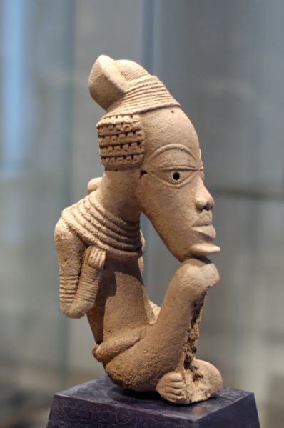
Iron use, in smelting and forging for tools, appears in Nok culture in Africa at least by 550 BC and more probably in the middle of the second millennium BC (between 1400 BC and 1600 BC depending on references)
Taruga is just one of the sites in central Nigeria where artifacts from the Nok culture have been excavated. Since 1945, similar figurines and pottery have been found in many other locations in the area, often uncovered accidentally by modern tin miners, and dating from before 500 BC to 200 AD. The region was probably moister and more heavily wooded during this period than it is today, but was still north of the zone of dense forests. The people would have subsisted by farming and cattle raising. As the climate gradually became drier, they would have drifted south, so the Nok people may have been the ancestors of people such as the Igala, Nupe, Yoruba and Ibo, whose artwork shows similarities to the earlier Nok artifacts.
As of October 2007, the Federal Government was being asked to protect and rehabilitate the site in view of its tourist potential. However, the site was threatened by illegal miners looking to develop the mineral resources.
Samun Dukiya
Samun Dukiya is a second archeological site in the Nok valley where artifacts from the Nok culture have been found, dating to between 300 BC and 100 BC.
Radio-carbon dating indicates that the site was occupied between 2500 and 2000 years ago. No traces of occupation before the Iron age have been found. The site contained broken pottery, iron and other artifacts, and fragments of terracotta statues which may have been used in shrines.
Read more at Wikipedia, articles on Taruba and the Nok culture.
You may be viewing yesterday's version of this page. To see the most up to date information please register for a free account.

Do not use the above information on other web sites or publications without permission of the contributor.
Click here to see more info for this site
Nearby sites
Click here to view sites on an interactive map of the areaKey: Red: member's photo, Blue: 3rd party photo, Yellow: other image, Green: no photo - please go there and take one, Grey: site destroyed
Download sites to:
KML (Google Earth)
GPX (GPS waypoints)
CSV (Garmin/Navman)
CSV (Excel)
To unlock full downloads you need to sign up as a Contributory Member. Otherwise downloads are limited to 50 sites.
Turn off the page maps and other distractions
Nearby sites listing. In the following links * = Image available
73.2km WSW 242° Abuja Cup Mark Stone Rock Art
81.2km SW 235° Jabi Cup Mark Stone Rock Art
85.6km SW 220° Waru Cup Mark Stone Rock Art
393.1km S 172° Ikom Monoliths* Standing Stones
814.8km N 6° Gobero Barrow Cemetery
853.0km NNE 13° Gobero Barrow Cemetery
977.0km N 359° Air Giraffe Rock Art Rock Art
1051.1km NNE 12° Adrar Madet (Massif) Stone Circle Stone Circle
1263.2km NNW 329° Adrar des Ifoghas petroglyphs Rock Art
1378.4km SW 220° Bronze Age Trackways Ancient Trackway
1378.4km SW 220° Fonte Vida* Holy Well or Sacred Spring
1378.4km SW 220° Pokotia Monolith* Sculptured Stone
1378.4km SW 220° Aukrug-Innien, Germany Hillfort
1378.4km SW 220° App Review: Turn Photos into Talking Avatars with Vidwud’s AI Talking Photo Tool NOT SET
1378.4km SW 220° Crowders Mountain stones Natural Stone / Erratic / Other Natural Feature
1378.4km SW 220° Bull Riding: The Heart-Pounding Sport That Canada Can’t Get Enough Of NOT SET
1378.4km SW 220° Ancient Civilizations Meet Modern Casino Gaming: Digital Adventures Through Time NOT SET
1378.4km SW 220° Pithenge (Szeged)* Henge
1378.4km SW 220° Carrowmore on the news NOT SET
1378.4km SW 220° New article by Aubrey Burl NOT SET
1378.4km SW 220° I just opened my site about megaliths in Belgium. NOT SET
1378.4km SW 220° Carrowmore - Dúchas criticised in Dail NOT SET
1378.4km SW 220° BBC feature Knowth Moon Stone - Pictures and Audio NOT SET
1378.4km SW 220° Mortar used in restoration damaging monuments NOT SET
1378.4km SW 220° Does anyone know anything about Craig Rhiwarth Hill Fort? Hillfort
View more nearby sites and additional images


 We would like to know more about this location. Please feel free to add a brief description and any relevant information in your own language.
 Wir möchten mehr über diese Stätte erfahren. Bitte zögern Sie nicht, eine kurze Beschreibung und relevante Informationen in Deutsch hinzuzufügen.
 Nous aimerions en savoir encore un peu sur les lieux. S'il vous plaît n'hesitez pas à ajouter une courte description et tous les renseignements pertinents dans votre propre langue.
 Quisieramos informarnos un poco más de las lugares. No dude en añadir una breve descripción y otros datos relevantes en su propio idioma.