Contributory members are able to log private notes and comments about each site
Sites thecaptain has logged. View this log as a table or view the most recent logs from everyone
Men-Marz
Trip No.214 Entry No.5 Date Added: 28th May 2020
Site Type: Standing Stone (Menhir)
Country: France (Bretagne:Finistère (29))
Visited: Yes on 16th Apr 2014. My rating: Condition 5 Ambience 4 Access 5
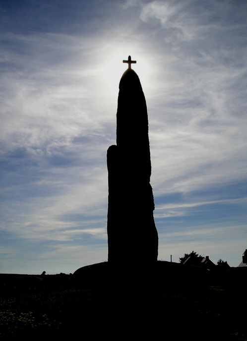
Men-Marz menhir submitted by thecaptain on 3rd Jul 2005. Men-Marz, the Miracle Stone, 8.5 metres tall, near Brignogan Plage in Brittany.
Photograph taken about 6:15 pm June 21 2005, summer solstice.
Cat * A *
(View photo, vote or add a comment)
Log Text: Had to bring Dad to see this fantastic menhir which is found to the north of Brignogan-Plage village and found by following plentiful signs. Men-Marz is set in a nice little area which has an information centre across the road with lots of informative boards.
At more than 8.5 metres high it is said to be the fourth largest menhir still standing in France. It is a strange shaped beast as are the natural rocks around here and looks to be a thin and straight beast when seen from front and back but is a sort of triangular shape when seen from the sides with multiple cavities and ledges in the sides.
The stone has suffered from Christianising vandalism on at least two occasions as it not only has a granite cross mounted on the top but there is also an engraved cross on the south-eastern corner about 1.5 metres from the ground. This stone has many legends attached to it which seem to get a bit mixed up and confused. There is a ledge high up on the south side which today had a lot of loose stones on it, attached to which are legends concerning marriage or childbirth. Both myself and Dad failed to land our stones on the ledge!
Men-Bihan Allée Couverte
Trip No.204 Entry No.55 Date Added: 11th Jul 2020
Site Type: Passage Grave
Country: France (Bretagne:Morbihan (56))
Visited: Yes on 13th Jul 2005. My rating: Condition 2 Ambience 4 Access 3
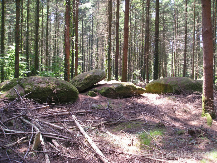
Men-Bihan allée couverte submitted by TheCaptain on 12th Aug 2007. About 50 metres from Men-Bihan is a line of 5 flat stones, looking very much like they have been placed there, although I am not 100% sure that this is a "proper" allée couverte.
There are many ruined allée couvertes hiding in this forest, and often the menhirs are marker stones for them.
(View photo, vote or add a comment)
Log Text: About 50 metres from Men-Bihan is a line of 5 flat stones, looking very much like they have been placed there. There might be remnants of stones underneath. The line is about 10 metres long, and is oriented roughly east to west. Is this the remains of an allée couverte, or just natural ?
Men-ar-Rompet
Trip No.203 Entry No.575 Date Added: 5th Jun 2020
Site Type: Passage Grave
Country: France (Bretagne:Côtes-D'Armor (22))
Visited: Yes on 25th Jun 2005. My rating: Condition 3 Ambience 3 Access 4
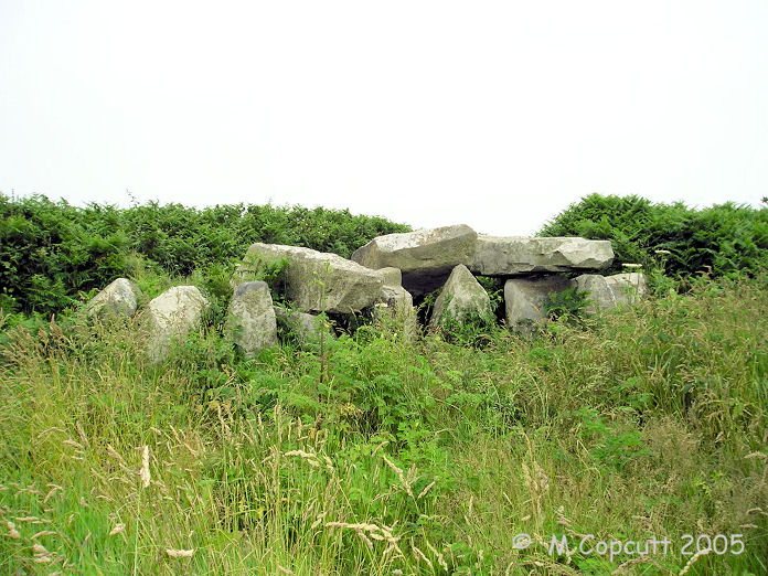
Men-ar-Rompet submitted by thecaptain on 27th May 2007. The remains of this allée couverte, "the Giants Stones", sit within a field wall (which is no doubt the reason for its survival) just 25 metres from the sea at high tide, near to the entrance of the Tréguier estuary.
(View photo, vote or add a comment)
Log Text: The remains of this allée couverte, "the Giants Stones", sit within a field wall (which is no doubt the reason for its survival) just 25 metres from the sea at high tide, near to the entrance of the Tréguier estuary. The chamber is quite short at about 6 metres, probably due to the eastern end being destroyed. The western end is intact with not only a back stone, but also an internal dividing stone a couple of metres in. Three capstones sit in place, with another one fallen at the east.
This would be a lovely place to sit and watch the boats and birds on a nice day, but a sea fog has developed and is enveloping everything, so the visibility is lacking. So much for my plans to go to the big sand spit (Siillon de Talbert) later. Uh Oh, its now started to rain. This allée couverte is signposted from the nearby Kerbors village, and is just a few hundred metres walk from a parking place.
Men Scryfa
Date Added: 18th Sep 2010
Site Type: Early Christian Sculptured Stone
Country: England (Cornwall)
Visited: Yes on 24th Feb 2004
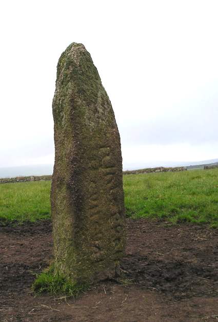
Men Scryfa submitted by TheCaptain on 24th Feb 2004. Men Scryfa
Inscribed standing stone near the Men-an-tol. July 2003
(View photo, vote or add a comment)
Log Text: None
Men Gurta
Date Added: 5th Nov 2019
Site Type: Standing Stone (Menhir)
Country: England (Cornwall)
Visited: Yes on 28th Sep 2012. My rating: Condition 4 Ambience 4 Access 4
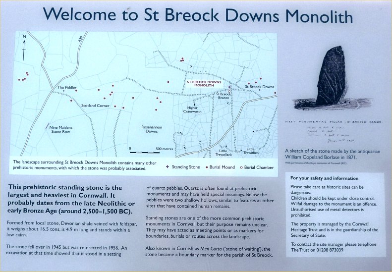
Men Gurta submitted by TheCaptain on 25th Mar 2013. There is a useful littel noticeboard up here, describing the stone and the local areas other prehistoric monuments
(View photo, vote or add a comment)
Log Text: Near the top of St Breock Down, this stone is easily reached along the little lanes to the south of Wadebridge. Men Gurta is the largest and heaviest standing stone in Cornwall. It is very nice up here in the sinking sun, with some terriffic views out to sea over the Camel estuary. I think the wind turbines add to the scene up here, other than their constant whining.
Men Braz menhir
Trip No.204 Entry No.56 Date Added: 11th Jul 2020
Site Type: Standing Stone (Menhir)
Country: France (Bretagne:Morbihan (56))
Visited: Yes on 13th Jul 2005. My rating: Condition 3 Ambience 5 Access 4
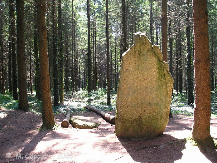
Men Braz menhir submitted by TheCaptain on 13th Aug 2007. Men Bras, the "big stone", is easy to find from the L'Etoiles roundabout. Take the forest track south for a couple of hundred metres, and then turn right at the signpost down a footpath, from where it is about 80 metres into the forest between the rows of trees.
(View photo, vote or add a comment)
Log Text: I wasted best part of an hour for this stone to clear of about 30 to 40 scouts having lunch and playing games here. Eventually they left so I could look at the stone on my own. It is easy to find from the L'Etoiles roundabout, where there is a few parking places. Take the forest track south for a couple of hundred metres, and then turn right at the signpost down a footpath, from where it is about 80 metres into the forest between the rows of trees. The "big stone" is about 3.8 metres tall, and looks lovely. Beside it is another fallen stone, perhaps even bigger.
Memorial stone to Richard Jefferies and Alfred Williams
Date Added: 18th Apr 2022
Site Type: Modern Stone Circle etc
Country: England (Wiltshire)
Visited: Yes on 17th Apr 2022. My rating: Condition 4 Ambience 4 Access 4

Memorial stone to Richard Jefferies and Alfred Williams submitted by TheCaptain on 18th Apr 2022. On the northern slopes of Burderop Down, Just to the east of Barbury Castle, stands this monument to two local authors, with great views over Swindon and the plains to the north.
Seen here looking east
(View photo, vote or add a comment)
Log Text: To the east of Barbury Castle, just below the ridge of Burderop Down, on the northern slopes below the wood and with great views over the plains to the north of the downs, is seen a stone standing. Closer inspection shows it to be concreted in place, and with two plaques mounted on it, as a memorial to Richard Jefferies and Alfred Williams, two local authors, and erected in 1939.
Megerie Menhir
Trip No.203 Entry No.297 Date Added: 26th Apr 2020
Site Type: Standing Stone (Menhir)
Country: France (Pays de la Loire:Loire-Atlantique)
Visited: Yes on 8th Jun 2005. My rating: Condition 3 Ambience 3 Access 3
Megerie Menhir submitted by AlexHunger on 3rd Jun 2005. About 2.5 Meter tall limestone block in fields, surounded by bushes in La Franquinerie, south of Nantes.
(View photo, vote or add a comment)
Log Text: This is a nearly 3 metres tall menhir, signposted down a little track at the hamlet of La Mégerie, in a field full of cows. It makes a strange hollow sound when I tapped it, perhaps its cracking apart, or perhaps its magic !
Meacombe Cist
Date Added: 18th Sep 2010
Site Type: Burial Chamber or Dolmen
Country: England (Devon)
Visited: Yes on 26th Aug 2007

Meacombe Cist submitted by TheCaptain on 26th Aug 2007. This is a nice little monument, with a relatively large and chunky capstone sitting on two side supports.
(View photo, vote or add a comment)
Log Text: None
Mayon menhir
Date Added: 19th Jul 2025
Site Type: Standing Stone (Menhir)
Country: England (Cornwall)
Visited: Yes on 18th Jun 2025. My rating: Condition 3 Ambience 3 Access 4

Mayon menhir submitted by AngieLake on 7th Dec 2015. Mayon menhir in May 2009, taken from a footpath en route to a coastal walk.
(View photo, vote or add a comment)
Log Text: From Sennen I move on to Mayon and then head down across the fields towards Sennen Cove. There is a stone standing in the field to the left, but I can only see the top above the crop. Continue diagonally down into Sennen Cove, the views from here are the best of Sennen and Whitesand bay to Cape Cornwall, so glad I did this bit.
Mayon Cliff cairn
Date Added: 5th Aug 2022
Site Type: Cairn
Country: England (Cornwall)
Visited: Yes on 14th Jun 2022. My rating: Condition 3 Ambience 5 Access 4
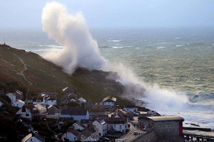
Mayon Cliff cairn submitted by theCaptain on 7th Jan 2014. Photo taken during the recent storms showing the force of the waves crashing onto Mayon Cliff above Sennen Cove. There is also a video available which shows the whole of the cliff completely awash.
Photo by Tony Armstrong Photography with their wishes for it to be shared.
(View photo, vote or add a comment)
Log Text: From Sennen Cove, I decide to walk up to the coastguard lookout shelter and on to look at the shipwreck of the RMS Mülheim, wrecked March 2003, the path passing right beside the Mayon Cliff cairn, and with the cliff castle clearly visible the other side.
Mayburgh
Date Added: 19th Oct 2022
Site Type: Henge
Country: England (Cumbria)
Visited: Yes on 20th Sep 2022. My rating: Condition 4 Ambience 4 Access 4

Mayburgh submitted by TerryStaniforth on 10th Jan 2007. Panorama at Mayburgh Henge in frost.
(View photo, vote or add a comment)
Log Text: After a fabulous breakfast its time to start my day. Once I have found my way out of Penrith, cross the river and turn right at Eaumont Bridge, right by King Arthur's Round Table henge. Right again before the motorway near a large millennium stone, and theres a parking area. Short walk to Mayburgh Henge, and what a fabulous place it is. Far bigger than I had imagined, the effort it must have taken to create this out of millions of river boulders and pebbles is astounding. I walk all around the henge taking a lot of pictures, none of which do it justice. The large stone standing in the middle really makes the place, along with all the old tree roots growing amongst the boulders. Terrific.
Maupertus menhir
Trip No.201 Entry No.12 Date Added: 25th Mar 2020
Site Type: Modern Stone Circle etc
Country: France (Normandie:Manche (50))
Visited: Yes on 22nd Nov 2004. My rating: Access 5
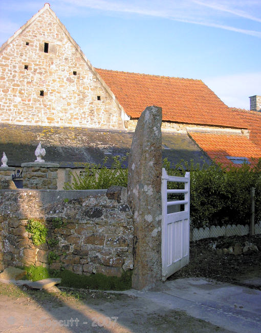
Maupertus menhir submitted by TheCaptain on 27th Sep 2007. On the main street through Maupertus-sur-Mer, is a large granite stone being used as a gatepost.
The stone looks very weathered, and is twice as high as it would need to be for the gatepost function it provides.
Is this one of the many ancient menhirs that used to be in this area reused ?
(View photo, vote or add a comment)
Log Text: On the main street through Maupertus-sur-Mer, just to the north of Cherbourg Airport is a large granite stone being used as a gatepost. The stone looks very weathered, and the edges are curved and worn, not straight or with any quarrying marks. It is also twice as high as it would need to be for the gatepost function it provides. Is this one of the many ancient menhirs that used to be in this area reused ?
Mas Neuf menhir
Trip No.205 Entry No.193 Date Added: 26th Nov 2020
Site Type: Standing Stone (Menhir)
Country: France (Languedoc:Gard (30))
Visited: Couldn't find on 21st Sep 2005
Log Text: I had a good look around for this menhir, but couldn't find anything.
Mas de Labat 2
Trip No.203 Entry No.209 Date Added: 21st Apr 2020
Site Type: Burial Chamber or Dolmen
Country: France (Midi:Lot (46))
Visited: Yes on 31st May 2005. My rating: Condition 3 Ambience 3 Access 3
Mas de Labat 2 submitted by ocdolmen on 30th Jul 2006. Mas de Labat dolmen 2.
There are 2 dolmens called Mas de Labat. One is covered and the other has lost its capstone.
(View photo, vote or add a comment)
Log Text: This is an odd dolmen incorporated into a wall. The small entrance below the capstone opens up into a typical 3m by 15 m chamber. The capstone itself is piled high with stone. Its not an easy dolmen to find with lots of windy lanes to negotiate before getting anywhere near the place and after that it took a bit of searching around in scrubby area round the back of a house and across a couple of fields.
Mas de Labat 1
Trip No.203 Entry No.208 Date Added: 21st Apr 2020
Site Type: Burial Chamber or Dolmen
Country: France (Midi:Lot (46))
Visited: Yes on 31st May 2005. My rating: Condition 2 Ambience 3 Access 3
Mas de Labat 1 submitted by ocdolmen on 30th Jun 2007. photo of Mas de Labat dolmen 1.
This monument has lost its capstone (it is 2 metres far from the burial chamber)
(View photo, vote or add a comment)
Log Text: Once the lane through Mas de Labat has been found this one is fairly easy to find as it is given away by the mound at the top of the hill amongst some scrubland in a field. Having said that it seems to be becoming very overgrown and indeed is not much more than a mound at the top of a hill now. At the centre of the mound a small 2 m by 0.7 m chamber can be seen between two side slabs visible amongst the bush. There was no sign of any capstone.
Mas de Greil Oppidum
Trip No.203 Entry No.147 Date Added: 15th Apr 2020
Site Type: Promontory Fort / Cliff Castle
Country: France (Midi:Lot (46))
Visited: Saw from a distance on 25th May 2005
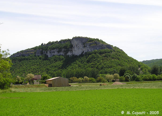
Mas de Greil Oppidum submitted by thecaptain on 21st Jan 2006. High on cliffs overlooking the Célé river, this hill has been inhabited and used as a hilltop refuge since 5000BC.
It doesn’t need much defending but there are 5 metre deep ditches across the neck of land attaching it to the high Causse.
(View photo, vote or add a comment)
Log Text: High on cliffs overlooking the Célé river this hill surrounded on 3 sides by high cliffs has been inhabited and used as a hilltop refuge since 5000BC. It doesn’t need much defending but there are 5 metre deep ditches across the neck of land attaching it to the high Causse.
Mas Cadenet dolmen
Trip No.205 Entry No.204 Date Added: 29th Nov 2020
Site Type: Passage Grave
Country: France (Provence:Bouches-du-Rhône (13))
Visited: Couldn't find on 22nd Sep 2005
Log Text: I could not find this dolmen or hypogae, there are lots of private property signs all around, although not the big fences this time.
Marsigalliet Dolmen 1
Trip No.203 Entry No.200 Date Added: 20th Apr 2020
Site Type: Burial Chamber or Dolmen
Country: France (Midi:Lot (46))
Visited: Yes on 31st May 2005. My rating: Condition 4 Ambience 4 Access 4
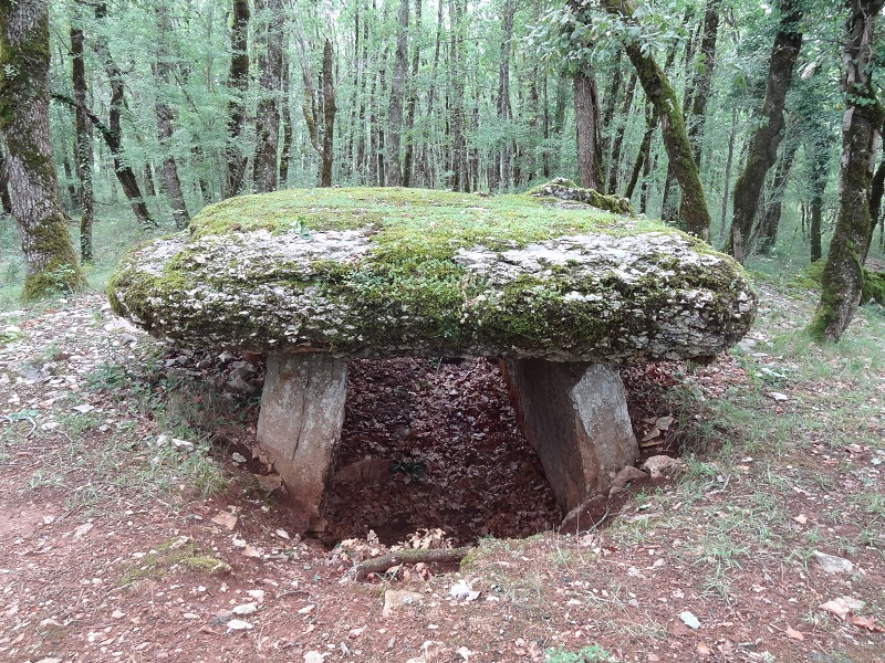
Marsigalliet Dolmen 1 submitted by johnstone on 8th Jan 2018. Nice dolmen in the wood, July 1, 2017
(View photo, vote or add a comment)
Log Text: This dolmen is found a couple of kilometres to the northwest of Laramière, along the GR.36 footpath, but which for this stretch is a driveable track. It is then a hundred or so metres walk into the forest, but signposted.
This is another much larger than average dolmen for round here, still mostly contained within its mound. Unfortunately, at some time in the past, the capstone and chamber ends have been broken and incorporated into a wall. The chamber is over 4 metres in length, 2 metres wide and 2 metres high, and faces substantially to the south of east, at 147°. The capstone was probably once nicely shaped, and 3.5 metres wide at the front end. There are other dolmens to be found in the woods around here.
Mardon Down S
Date Added: 28th Sep 2020
Site Type: Stone Circle
Country: England (Devon)
Visited: Yes on 26th Feb 2019. My rating: Condition 3 Ambience 4 Access 3
Mardon Down S submitted by TheCaptain on 25th Mar 2019. View across Mardone Down stone circle. I was slightly surprised to find it so cleared of all the gorse, and easy to find.
Who could believe this was February on Dartmoor !
(View photo, vote or add a comment)
Log Text: Further south along the ridgetop path, and I arrive at a large wide open green area, where I can see the remains of the stone circle extending around the exterior. The first part I get to has another of what looks like a little cairn right on the circumference of the circle, but again the hole in the centre looking too deep and recent. I initially wonder whether I can see the remains of a sort of cist capstone at one place, but which later I wonder whether it is one of the remaining circle stones fallen and buried here. The circle is the largest on Dartmoor at 38 metres diameter and clear to see, but in a very ruinous state, with only 2 or 3 stones still standing of what was probably once between 60 and 70. There is still a nice arc of stones on the southeast side, with one still standing and a large fallen block. Opposite to this on the northwest side is another good arc, with one very interesting shaped large slab still standing, and a couple more a bit further round. I dont get great feelings here, probably as its all pretty much wrecked, and too easy to find. Perhaps it would have been more atmospheric it it was all still hidden and lurking within the gorse. This gorse was still surruounding the whole circle, preventing seeing any of the fabulous views available from elsewhere on the hill.
