

<< Our Photo Pages >> Megerie Menhir - Standing Stone (Menhir) in France in Pays de la Loire:Loire-Atlantique
Submitted by AlexHunger on Saturday, 16 April 2005 Page Views: 3080
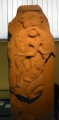
Neolithic and Bronze AgeSite Name: Megerie MenhirCountry: France Département: Pays de la Loire:Loire-Atlantique Type: Standing Stone (Menhir)
Nearest Town: Paimboeuf Nearest Village: La Franquinerie
Latitude: 47.249200N Longitude: 2.0807W
Condition:
| 5 | Perfect |
| 4 | Almost Perfect |
| 3 | Reasonable but with some damage |
| 2 | Ruined but still recognisable as an ancient site |
| 1 | Pretty much destroyed, possibly visible as crop marks |
| 0 | No data. |
| -1 | Completely destroyed |
| 5 | Superb |
| 4 | Good |
| 3 | Ordinary |
| 2 | Not Good |
| 1 | Awful |
| 0 | No data. |
| 5 | Can be driven to, probably with disabled access |
| 4 | Short walk on a footpath |
| 3 | Requiring a bit more of a walk |
| 2 | A long walk |
| 1 | In the middle of nowhere, a nightmare to find |
| 0 | No data. |
| 5 | co-ordinates taken by GPS or official recorded co-ordinates |
| 4 | co-ordinates scaled from a detailed map |
| 3 | co-ordinates scaled from a bad map |
| 2 | co-ordinates of the nearest village |
| 1 | co-ordinates of the nearest town |
| 0 | no data |
Internal Links:
External Links:
I have visited· I would like to visit
johnstone visited on 9th Jul 2013 - their rating: Cond: 4 Amb: 4 Access: 3
TheCaptain visited on 8th Jun 2005 - their rating: Cond: 3 Amb: 3 Access: 3 This is a nearly 3 metres tall menhir, signposted down a little track at the hamlet of La Mégerie, in a field full of cows. It makes a strange hollow sound when I tapped it, perhaps its cracking apart, or perhaps its magic !
Average ratings for this site from all visit loggers: Condition: 3.5 Ambience: 3.5 Access: 3
")
You may be viewing yesterday's version of this page. To see the most up to date information please register for a free account.
")
")
")
Do not use the above information on other web sites or publications without permission of the contributor.
Nearby Images from Flickr


The above images may not be of the site on this page, but were taken nearby. They are loaded from Flickr so please click on them for image credits.
Click here to see more info for this site
Nearby sites
Click here to view sites on an interactive map of the areaKey: Red: member's photo, Blue: 3rd party photo, Yellow: other image, Green: no photo - please go there and take one, Grey: site destroyed
Download sites to:
KML (Google Earth)
GPX (GPS waypoints)
CSV (Garmin/Navman)
CSV (Excel)
To unlock full downloads you need to sign up as a Contributory Member. Otherwise downloads are limited to 50 sites.
Turn off the page maps and other distractions
Nearby sites listing. In the following links * = Image available
458m W 262° Cassis Menhir* Standing Stone (Menhir)
917m ESE 115° La Gauterie Dolmen* Burial Chamber or Dolmen
1.2km S 177° Les Landes Menhir* Standing Stone (Menhir)
1.6km SE 137° La Roche Govi Menhir* Standing Stone (Menhir)
1.7km NE 39° Menhir dit la Pierre Bonde* Standing Stone (Menhir)
1.7km S 187° La Bellevue Menhir* Standing Stone (Menhir)
1.9km NNE 34° La Haute Gedeliere Dolmen* Passage Grave
2.3km NNE 12° Les Pierres Blanches (Corsept)* Standing Stones
4.6km W 263° Moulin Chevalier Dolmen* Passage Grave
4.8km SSW 200° Le Riverais 2* Standing Stone (Menhir)
4.9km SSW 201° Le Riverais 1* Standing Stone (Menhir)
5.6km ENE 60° Menhir de la Tuterie* Standing Stone (Menhir)
5.6km W 276° Plessis Gamat Menhir* Standing Stone (Menhir)
5.8km NE 48° Pierre Pointue (Paimboeuf)* Standing Stone (Menhir)
5.9km WSW 236° Pont Gaulois* Ancient Trackway
6.3km WNW 285° La Pierre de Gargantua (St Brevin)* Standing Stone (Menhir)
6.6km W 268° Les Fesses du Diable* Sculptured Stone
6.6km W 268° Saint-Brevin-les-Pins Menhir* Standing Stone (Menhir)
6.6km W 269° Pierre Guillou* Standing Stone (Menhir)
6.8km WSW 253° Rossignols Dolmen* Burial Chamber or Dolmen
6.8km NNE 12° Menhir de la Vacherie (Donges)* Standing Stone (Menhir)
6.9km NNE 12° Dolmen de la Vacherie (Donges)* Burial Chamber or Dolmen
7.0km N 1° La Roche Dolmen (Donges) Burial Chamber or Dolmen
7.2km SW 227° Les Pierres Couchées* Standing Stone (Menhir)
7.2km SW 225° Pierre de Couche* Standing Stone (Menhir)
View more nearby sites and additional images


 We would like to know more about this location. Please feel free to add a brief description and any relevant information in your own language.
 Wir möchten mehr über diese Stätte erfahren. Bitte zögern Sie nicht, eine kurze Beschreibung und relevante Informationen in Deutsch hinzuzufügen.
 Nous aimerions en savoir encore un peu sur les lieux. S'il vous plaît n'hesitez pas à ajouter une courte description et tous les renseignements pertinents dans votre propre langue.
 Quisieramos informarnos un poco más de las lugares. No dude en añadir una breve descripción y otros datos relevantes en su propio idioma.