Contributory members are able to log private notes and comments about each site
Sites theCaptain has logged. View this log as a table or view the most recent logs from everyone
St Lythans
Date Added: 26th Apr 2024
Site Type: Chambered Tomb
Country: Wales (South Glamorgan)
Visited: Yes on 25th Apr 2024. My rating: Condition 3 Ambience 3 Access 4
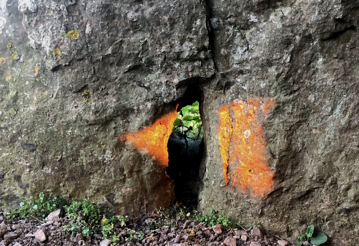
St Lythans submitted by Mark_in_Wales on 22nd Jun 2022. Photo Competition 2022 WINNING ENTRY. This light beam was photographed at 21:14 BST on the 20th of June 2022. St Lythans Burial Chamber is a highly accurate tool for determining the Winter Calendar and making this stunning Arrowhead light-beam at Midsummer. The arrowhead shape (known as an oblique arrowhead in academic circles) is extremely precise, with a straight back, curved cutting surface and hooked single tang. The light-beam is formed by only three stones and the angle of the wall it is b...
(View photo, vote or add a comment)
Log Text: Time for another visit to St Lythams and Tinkinswood. Very nice in the lush springtime
St Lythans
Date Added: 26th Apr 2024
Site Type: Chambered Tomb
Country: Wales (South Glamorgan)
Visited: Yes on 11th Jul 2004. My rating: Access 4
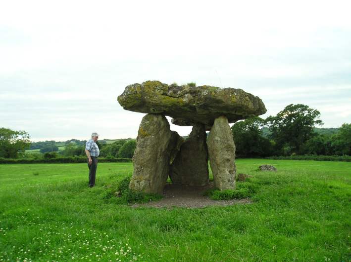
St Lythans submitted by thecaptain on 9th Aug 2004. A picture of this massive structure with my Dad beside it for scale. They sure must have been big dogs who lived in here !
(View photo, vote or add a comment)
Log Text: None
Graig Lwyd Cairns
Date Added: 7th Nov 2023
Site Type: Cairn
Country: Wales (Conwy)
Visited: Yes on 13th Sep 2023. My rating: Condition 3 Ambience 3 Access 2
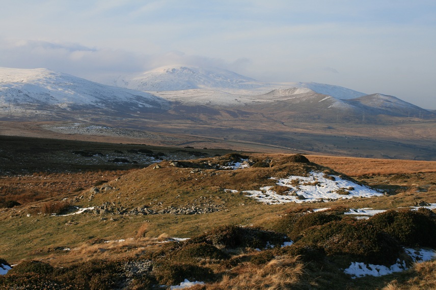
Graig Lwyd Cairns submitted by postman on 15th Apr 2013. Some magic views from here
(View photo, vote or add a comment)
Log Text: Last on my itinerary for today are the Graig Lwyd Cairns. There is the one large cairn within the open access land which looks like a cartoon volcano, conical, steep sides and a crater in the top. Viewed with Moelfre and the other mountains behind it, it reminds me very much of the chains of volcanoes in the Auvergne. The other cairns are in the walled and fenced off fields to the north, and I have no way through to have a close look. However from a low point in the wall, I can make out a couple of places where there are stones standing proud of the ground, possibly a bit like Circle 275. Time to get back down to Penmaenmawr, I have been up here much longer than I initially intended, but then again it has been glorious up here and I am in no real rush other than to get a pint before the pubs shut. The path down is a killer on the knees, so steep and long, I can hardly walk by the time I get back to the car. In need of a pint, time to check what might be open using the useful WhatPub link on the Portal's sitepages. Disappointingly, if its correct, the Fairy Glen will be closed, but the Gladstone in nearby Dwygyfylchi is open, where I have a nice sit outside in the sunshine with a pleasant pint of Facer's, a new brewery to me.
Battery Point
Date Added: 6th Nov 2023
Site Type: Modern Stone Circle etc
Country: England (Somerset)
Visited: Yes on 3rd Mar 2016. My rating: Condition 4 Ambience 5 Access 4
Battery Point submitted by TheCaptain on 6th Mar 2016. The Seafarers Memorial Stone, at Battery Point, Portishead.
(View photo, vote or add a comment)
Log Text: A nice stone with many fossilised shells to be seen within it, stands strategically at Battery Point, Portishead, as the Seafarers Memorial Stone, a memorial to seafarers of the west country. The stone monument marks the closest place on a UK coast which large ships pass. The dedication is to the seafarers of the West Country who, “since the Middle Ages, on voyages of discovery in times of peace and war, have passed this point, some never to return.”
Eastwood Fort, Portishead
Date Added: 6th Nov 2023
Site Type: Hillfort
Country: England (Somerset)
Visited: Yes on 3rd Mar 2016. My rating: Condition 2 Ambience 4 Access 4
Eastwood Fort, Portishead submitted by TheCaptain on 6th Mar 2016. The western end of Eastwood Hill and fort, as seen from Battery Point.
(View photo, vote or add a comment)
Log Text: Ancient woodland covered limestone hill, now a nature reserve, to the north of Portishead, beside the shipping channel into Portbury and Avonmouth docks, and the river Avon up to Bristol. As such has been an important strategic place since history began. There's a lot of history to the area - the remains of an Iron Age fort can be seen above the path on the north side of the Wood. The Romans also arrived at some point. World War 2 gun emplacements were sited at Battery Point and a military presence has been here as far back as the Civil War when a fort on the site was stormed by parlimentarians.
Blaise Castle
Date Added: 6th Nov 2023
Site Type: Hillfort
Country: England (Gloucestershire)
Visited: Yes on 29th Aug 2011. My rating: Condition 4 Ambience 4 Access 4
Blaise Castle submitted by theCaptain on 1st Dec 2011. Some of the remaining ramparts on the northern side of the hill
(View photo, vote or add a comment)
Log Text: None
Burwalls Camp
Date Added: 6th Nov 2023
Site Type: Promontory Fort / Cliff Castle
Country: England (Somerset)
Visited: Yes on 28th Aug 2011. My rating: Condition 2 Ambience 4 Access 5
Burwalls Camp submitted by theCaptain on 15th Sep 2011. View of the site of Burwalls Camp, as seen from Clifton Down Camp across the Avon Gorge.
In the woods to the right, the steep sided Nightingale Valley, which separates Burwalls Camp from Stokeleigh Camp.
(View photo, vote or add a comment)
Log Text: The Burwalls Camp hillfort is one of three iron age forts here probably guarding a ford crossing of the river Avon at the bottom of the Avon Gorge, below where is now the Clifton Suspension Bridge. Now mostly destroyed, with the western end of the Clifton Bridge and massive houses built all over it, a few remnants of the original ramparts can still be seen among the gardens of Burwalls. The neighbouring forts are Stokeleigh camp, just across Nightingale Valley, also on the western side of the Avon Gorge, and Clifton Down Camp on the eastern, Clifton side.
Stokeleigh Camp
Date Added: 6th Nov 2023
Site Type: Promontory Fort / Cliff Castle
Country: England (Somerset)
Visited: Yes on 28th Aug 2011. My rating: Condition 4 Ambience 4 Access 4

Stokeleigh Camp submitted by TheCaptain on 19th Aug 2011. Plan of Stokeleigh Camp from
Notes on the Clifton, Burwalls and Stokeleigh Camps
by Professor C. Lloyd Morgan,
Clifton Antiquarian Club 1900.
(View photo, vote or add a comment)
Log Text: Iron age promontary hillfort on a spur overlooking the Avon Gorge from the high plateau at the western side of the Gorge, now a part of the large Leigh Woods nature reserve. This is one of three iron age forts here probably guarding a ford crossing of the river Avon at the bottom of the Avon Gorge, below where is now the Clifton Suspension Bridge. The promontary points towards the east, with the steep sided Nightingale valley marking the southern edge, where the hillside has been sculpted, with another smaller steep sided valley making the northeastern edges of the camp. The camp is completed around its northwestern sides by a double arc of massive ditch and bank ramparts, both once topped with stone walling. The main entrance was probably at the northern edge of the plateau, beside the steep cliff edge, where there is a third row of ditch and bank to help gaurd. I decided on a walk round Leigh Woods and to take in Stokeleigh Camp, on a showery bank holiday afternoon. Several things took my notice since my last visit here many years ago, firstly that it has all been tidied up by National Trust and much of the woodland cleared around the ramparts, making them very visible (I wasn't expecting to really be able to see them or get any decent pictures at all). I was most impressed with the massive size of the main ramparts, the inner bank being about 5 metres above the ground level inside, while the ditch outside must be almost of equal depth, making a top to bottom height of between 8 and 10 metres! Massive! Outside the inner bank and ditch is a second ring of bank and ditch, this time the relative heights and depth being about +/- 2 metres. At places around the top of the major rampart, there are places where stretches of vertical stone walling can be seen. In order to keep the vegetation down, NT and English Nature have decided to graze half a dozen Devon Red cattle around the camp.
King's Weston Hill barrow cemetary
Date Added: 6th Nov 2023
Site Type: Barrow Cemetery
Country: England (Gloucestershire)
Visited: Yes on 29th Aug 2011. My rating: Condition 2 Ambience 4 Access 3
King's Weston Hill barrow cemetary submitted by theCaptain on 13th Apr 2012. Walk several hundred metres west along the hilltop ridge from the Kings Weston Hillfort, past the large circular earthwork, across the roman road and its earthwork bank, and the open grassland of the hilltop now has several bushy clumps dotted around.
Some of these clumps hide the remains of several bronze age burial mounds.
(View photo, vote or add a comment)
Log Text: Walk several hundred metres west along the hilltop ridge from the Kings Weston Hillfort, past the large circular earthwork, across the roman road and its earthwork bank, and the open grassland of the hilltop now has several bushy clumps dotted around. Some of these clumps hide the remains of several bronze age burial mounds. The burial mounds are not in the best of condition, but are thought to date back to almost 2000BC. It is a very pleasant spot up on this hilltop, surrounded by the northwestern suburbs of Bristol, but you would hardly know it, and can easily get taken back in time while up here.
King's Weston Hill stockpound
Date Added: 6th Nov 2023
Site Type: Misc. Earthwork
Country: England (Gloucestershire)
Visited: Yes on 29th Aug 2011. My rating: Condition 2 Ambience 3 Access 4
King's Weston Hill stockpound submitted by theCaptain on 13th Apr 2012. plan on the noticeboard showing the various items of historical interest on the King's Weston Hill ridgetop
(View photo, vote or add a comment)
Log Text: A few hundred metres west along the hilltop ridge from the Kings Weston Hillfort can be seen the remains of a large circular earthwork, of unsure date. People have been living and working on this hilltop ridge since neolithic times, and it is thought that this earthwork is some sort of stockpound dating from perhaps bronze or iron age times. It is a very pleasant spot up on this hilltop, surrounded by the northwestern suburbs of Bristol, but you would hardly know it, and can easily get taken back in time while up here.
King's Weston Hillfort
Date Added: 6th Nov 2023
Site Type: Hillfort
Country: England (Gloucestershire)
Visited: Yes on 29th Aug 2011. My rating: Condition 3 Ambience 3 Access 4
King's Weston Hillfort submitted by theCaptain on 13th Apr 2012. The northeastern end of the ridge that is Kings Weston Hill.
(View photo, vote or add a comment)
Log Text: At the northeastern end of the ridge that is Kings Weston Hill, now in the northwestern suburbs of Bristol, is to be found the remains of an iron age hillfort and farmstead. It is situated in parkland, just to the southwest of the more impressive Blaise Castle. The hill and immediately surrounding area is nowadays parkland, a part of the Blaise Castle estate. The steeply sloping sides of the hill are thick woodland, while the flat top of the ridge is open grassland, and makes for a nice walk. There is an informative noticeboard. The defended enclosure at the end of the ridge has been dated to 800BC and was in use until Roman times. The steep northern edge of the ridge still has some remains of earthern ramparts, while on the flat top of the hill is a rectangular banked enclosure.
Cors Y Carneddau
Date Added: 6th Nov 2023
Site Type: Stone Circle
Country: Wales (Conwy)
Visited: Yes on 13th Sep 2023. My rating: Condition 3 Ambience 4 Access 2
Cors Y Carneddau submitted by TimPrevett on 14th Sep 2004. A much clearer picture of the location of the Cors Y Carneddau circle.
See main entry for full details.
(View photo, vote or add a comment)
Log Text: I head down to the west and back to the lower track in order to find the Cors Y Carneddau circle. At first I found lots of stones all seemingly scattered around at random, with nothing obvious representing a circle. Some stones are standing proud of the ground over by the wall. But nothing that shouts circle to me. Having a more detailed search of the area, I was at one point heading back to the east, and then an arc of stones came into view. Was this it? Looking closer and several more stones were found under the surface, and for sure this is the remains of a circle, perhaps 10 stones remaining in the circumference, with a diameter of 15 metres or so. The giveaway to being in the right place is a steel bar sticking out of the ground, probably once a fence post, nearby to the two most obvious stones.
Cefn Coch (Penmaenmawr)
Date Added: 6th Nov 2023
Site Type: Ring Cairn
Country: Wales (Conwy)
Visited: Yes on 13th Sep 2023. My rating: Condition 3 Ambience 4 Access 2

Cefn Coch (Penmaenmawr) submitted by LivingRocks on 26th Apr 2005. Cefn Coch as seen when coming over the ridge from Monument 280.
(View photo, vote or add a comment)
Log Text: Having done my research beforehand, I now know to head up and over the nearby ridge to the south and there is the lovely ring cairn, about 10 to 12 metres diameter. It doesn't stand very proud of the ground, and has quite wide "walls".
Monument 280
Date Added: 5th Nov 2023
Site Type: Ring Cairn
Country: Wales (Conwy)
Visited: Yes on 13th Sep 2023. My rating: Condition 3 Ambience 4 Access 2
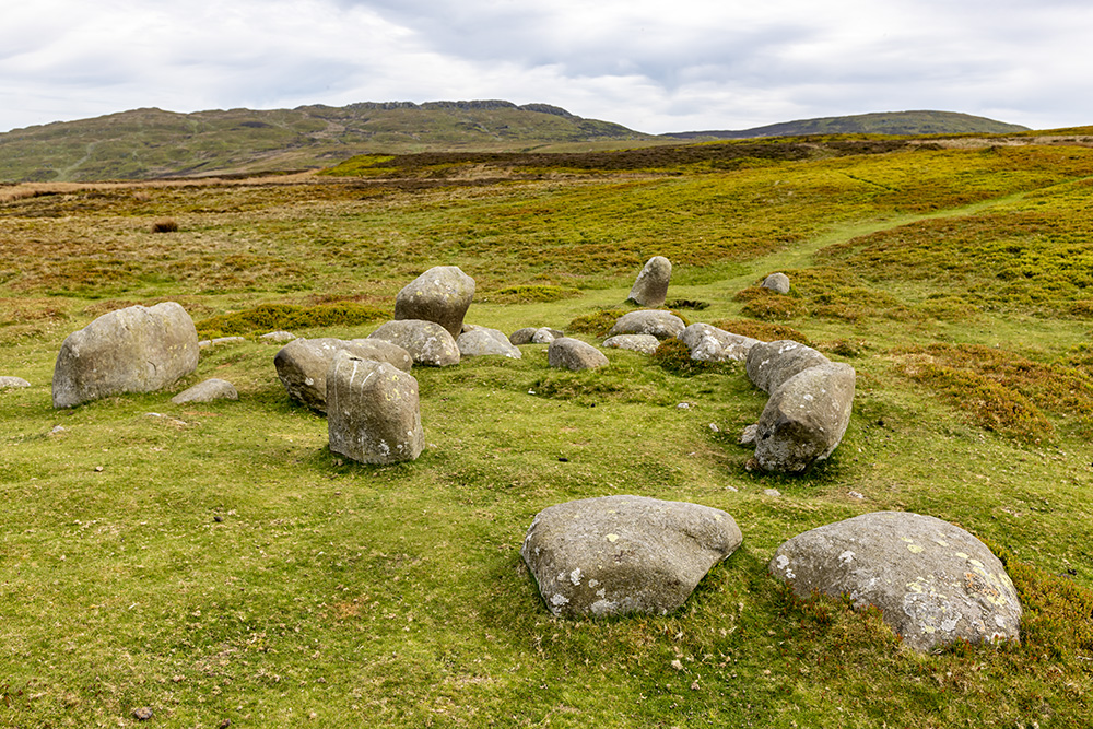
Monument 280 submitted by nigeynoo on 21st May 2018. Monument 280 taken May 20 on a very peaceful afternoon
(View photo, vote or add a comment)
Log Text: Over a couple of mounds, and there is another catchily named site, Monument 280, of which I have no idea what type of site this is. There are many stones stood and arranged, but with no obvious pattern. There is a circle in the middle of them, and several in a straight line through the middle. Is that a burial cist beside one of the large stones? I see online something which states that in 1845 this was described as three circles. Time for lunch, and I notice a pair of glasses within what looks to me like a burial cist, with a leather strap hanging over the large stone beside it.
Druids Circle (Penmaenmawr)
Date Added: 4th Nov 2023
Site Type: Stone Circle
Country: Wales (Conwy)
Visited: Yes on 13th Sep 2023. My rating: Condition 5 Ambience 4 Access 2
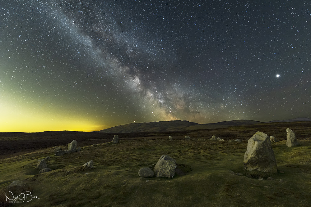
Druids Circle (Penmaenmawr) submitted by nigeynoo on 24th Apr 2018. The magical Druids Circle taken at night with the Milky Way, Mars, Saturn and Jupiter
(View photo, vote or add a comment)
Log Text: From circle 275 the stones of the Druids Circle can be seen up on the hill against the skyline. I make straight for it, but this is probably not the best way as it takes me through a little valley with lots of boggy area to get through. The site is positioned on a flattened platform area, with an embanked circle of stones about 35 metres diameter. Several of the stones are large and standing upright, many much smaller and some are flat to the ground. The position up here is gorgeous with the views out and over the sea with the Great Orme to the east, and Anglesey to the west. There are a couple here taking it all in, with the lady sat sketching the circle. I was intending having my lunch here, but I move on to the next site for that, so we do not disturb each other.
Circle 275
Date Added: 30th Oct 2023
Site Type: Stone Circle
Country: Wales (Conwy)
Visited: Yes on 13th Sep 2023. My rating: Condition 3 Ambience 4 Access 2
Circle 275 submitted by Baz on 26th Jul 2002. Circle 275 Stone Circle, Penmaenmawr.(SH725747)
Five stones in a very small circle with a diameter of 13ft.
The Druids` Circle is on the horizon on the left.
(View photo, vote or add a comment)
Log Text: Next up is the snappily named Circle 275, which is to the south of the trackway in the long grass and heather. This is a lovely little circle of five stones with diameter about 3 metres, and in a most gorgeous setting with views out over the sea and up to the hills with the druids circle visible on the skyline. Is that a spiral carving I see on one of the stones?
Fridd Wanc
Date Added: 30th Oct 2023
Site Type: Round Barrow(s)
Country: Wales (Conwy)
Visited: Yes on 13th Sep 2023. My rating: Condition 3 Ambience 3 Access 2
Fridd Wanc submitted by TimPrevett on 13th Sep 2004. Remains of a round barrow not far from Circle 275; see main entry for details.
(View photo, vote or add a comment)
Log Text: Moving on and the next site just to the north of the trackway is the Fridd Wanc mound, with a telegraph pole standing from its centre. Just to the southeast are several boulders, three obvious large stones, with a couple more not so obvious. Is it the remains of an ancient burial chamber? Or on later thinking, another little circle?
Maen Crwn
Date Added: 30th Oct 2023
Site Type: Standing Stone (Menhir)
Country: Wales (Conwy)
Visited: Yes on 13th Sep 2023. My rating: Condition 3 Ambience 3 Access 2
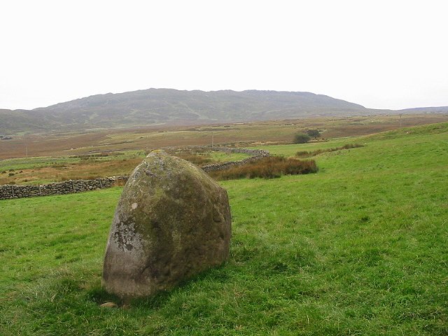
Maen Crwn submitted by stu on 16th Oct 2002. Nice standing stone in field outside Red Farm.
(View photo, vote or add a comment)
Log Text: A bit further southwest, and now into an open paddock like area below the farm, and this large stone is stood in the open grass below an avenue of trees. It has a scratches T + J on its southern face, along with other graffitti.
Red Farm
Date Added: 30th Oct 2023
Site Type: Stone Circle
Country: Wales (Conwy)
Visited: Yes on 13th Sep 2023. My rating: Condition 2 Ambience 3 Access 2
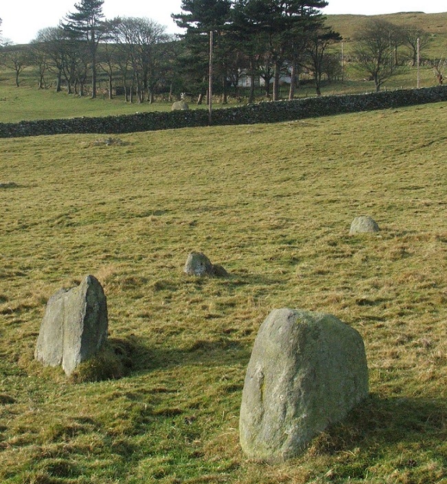
Red Farm submitted by postman on 24th Nov 2012. Looking over the remnants of Red Farm stone circle to Maen Crwn
(View photo, vote or add a comment)
Log Text: Walking up from Penmaenmawr, once up on the plateau, the first site I see is the Red Farm stone circle. Its over a wall in a field containing horses, and there are lots of people out looking like they are on an organised shooting event, so I satisfy myself with the view over the wall. Looks like about 4 stones on a flattened platform, with a couple of other either outliers or moved stones laying around.
Fox Covert NW
Date Added: 28th Aug 2023
Site Type: Chambered Tomb
Country: England (Wiltshire)
Visited: Yes on 9th Sep 2007

Fox Covert NW submitted by TheCaptain on 18th Sep 2007. Overgrown Long Barrow which has been cut in two by a hedge.
The eastern part of the barrow in the eastern field has now been completely ploughed out. The part in the western field is now about 30 metres in length, about 20 metres wide and up to 2 metres in height.
(View photo, vote or add a comment)
Log Text: A badly damaged overgrown Long Barrow with possible Chambered Tomb in a field, which has been cut in two by a hedge. The eastern part of the barrow in the eastern field has now been completely ploughed out. The part in the western field is now about 30 metres in length, about 20 metres wide and up to 2 metres in height. There are one or two big stones, which are almost certainly field clearance, dumped on top, otherwise there were no noticeable features that I could see. There are a few other tumuli marked on maps in neighbouring fields, but as far as I could see, these have no all been completely ploughed out, including the Tormarton 1 (Gloucestershire) long barrow in the field just to the north of the lane here.
