Contributory members are able to log private notes and comments about each site
Sites theCaptain has logged. View this log as a table or view the most recent logs from everyone
Pors Poulhan allée couverte
Trip No.203 Entry No.474 Date Added: 25th May 2020
Site Type: Passage Grave
Country: France (Bretagne:Finistère (29))
Visited: Yes on 17th Jun 2005. My rating: Condition 5 Ambience 4 Access 5
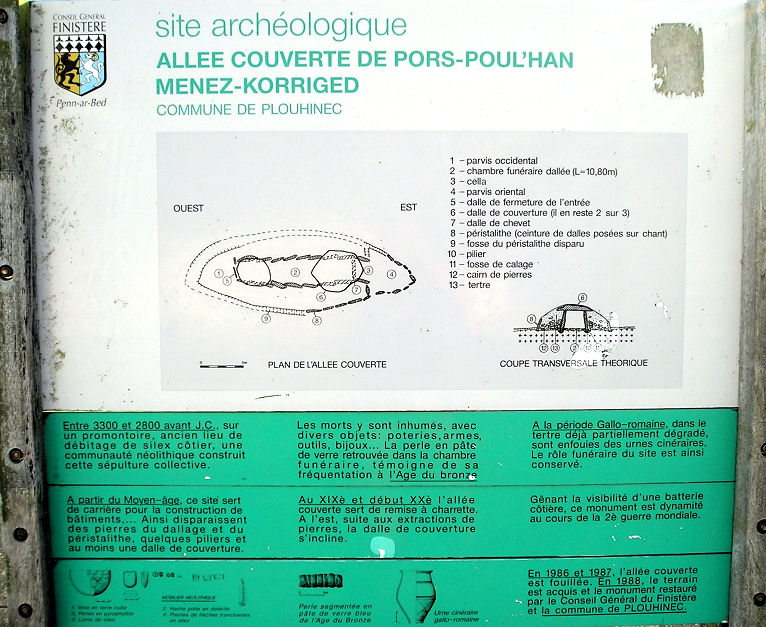
Pors Poulhan allée couverte submitted by thecaptain on 16th May 2009. The information board at Pors Poulhan allée couverte.
(View photo, vote or add a comment)
Log Text: On a headland overlooking the Baie D'Audierne, this allée couverte is in a tremendous position. The 12 metre long passage is quite large and wide at almost 2 metres in width, and almost as high, and lines up to the east at 100°.
Built before the year 3000BC, it has been used almost continually for one purpose or another until the present day. Excavations have shown it to have not only been constructed and used by neolithic flint workers, but also for burials in the bronze age, iron age, and by the Gallo-Romans. In the middle ages it was used as a quarry for building stone, and since then it has been used as a military look out post, and as such was blown up during the second world war.
Restoration was made in about 1990, with it now in a nicely kept little grassy area with benches and an information board. Two capstones are in place, as is a lot of floor paving, but the unusual thing for around here is that it still has many of the stones from its surrounding peristalith. This is a nice place to sit and ponder.
Presqu'île de la Torche
Trip No.203 Entry No.470 Date Added: 25th May 2020
Site Type: Passage Grave
Country: France (Bretagne:Finistère (29))
Visited: Yes on 17th Jun 2005. My rating: Condition 3 Ambience 5 Access 4

Presqu'île de la Torche submitted by thecaptain on 18th May 2009. The remains of what would no doubt have once been a magnificent monument, is positioned on top of this little headland, almost an island, sticking dramatically out into the wild Atlantic Ocean, and surrounded by magnificent surf beaches.
(View photo, vote or add a comment)
Log Text: The remains of what would no doubt have once been a magnificent monument, positioned on top of this little, almost an island, headland, sticking dramatically out into the wild Atlantic Ocean, and surrounded by magnificent surf beaches.
The central passage is still 16 metres in length, running up and over the top of the mound, curving as it goes, and opening to the east. At the west end there is an upright end stone. On the top of the mound, a few metres in from the end stone, are two side chambers each about 3 metres by 1.5 metres, one of which still has capstones in place, although it is all much ruined. Considering the concrete all around, for wartime bunkers and lookout posts, and for tourist paths and observation tables, it is surprising anything has survived here - that so much has is incredible. There is possible some remnants of a second chamber up here too.
The most wonderful thing about this place is the situation. The surf is crashing in all around the end of the point, and the waves rolling by on both sides of the headland in this surfers paradise. Its a fantastic place to sit and watch the waves go by. I love it. It makes me want to go surfing again. I bet I could still do it. They are even playing Camel's "Snow Goose" in the bar at the car park. Now if that isn't meaningful......
Corn-ar-Palud
Trip No.203 Entry No.472 Date Added: 25th May 2020
Site Type: Chambered Cairn
Country: France (Bretagne:Finistère (29))
Visited: Yes on 17th Jun 2005. My rating: Condition 2 Ambience 4 Access 4
Corn-ar-Palud submitted by thecaptain on 9th Mar 2007. In the dunes near the edge of the beach at the almost deserted centre of Audierne Bay, can be found the remains of a cairn with a few large rocks to be seen scattered around in it.
(View photo, vote or add a comment)
Log Text: Beside the little road running along the coast around the almost deserted centre of Audierne Bay, just on the edge of the beach in the dunes, can be found the remains of a cairn with a few large rocks to be seen scattered around in it. Looking closer at some of these larger rocks, there is evidence of a chamber underneath one capstone. Obviously once upon a time this was a fairly complex place, probably a cairn with several dolmenic chambers within it, similar to many other places in this far southwestern tip of Brittany.
This really is a splendid place, with the surf rolling in creating its own mist and covering the land in clouds. Amazing.
Alignements de Gueldro
Trip No.203 Entry No.446 Date Added: 23rd May 2020
Site Type: Stone Row / Alignment
Country: France (Bretagne:Morbihan (56))
Visited: Couldn't find on 16th Jun 2005
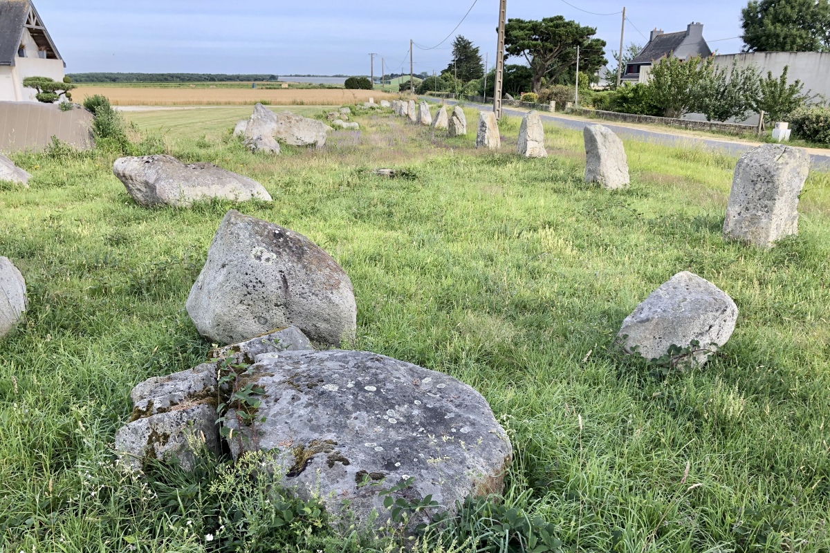
Alignements de Gueldro submitted by Lasmatik on 27th Jun 2020. Site in Bretagne:Morbihan (56) France
(View photo, vote or add a comment)
Log Text: I had three attempts at finding the remnants of this once important set of eight parallel rows, but found nothing. The best I found was a bit of uncultivated land, completely covered in gorse and not possible to get to, which was in about the right place, so that was probably it. I found no signs or any other reference to it until afterwards, and the place I found was definately the right place.
Allée Couverte de Kérandrège
Trip No.203 Entry No.453 Date Added: 23rd May 2020
Site Type: Passage Grave
Country: France (Bretagne:Finistère (29))
Visited: Yes on 16th Jun 2005. My rating: Condition 4 Ambience 3 Access 4
Allée Couverte de Kérandrège submitted by richardhtc on 12th Sep 2006.
(View photo, vote or add a comment)
Log Text: In a field to the left of the D116 road to the south of Moelan-sur-Mer on the way to Brigneau can be found this lovely allée couverte with an associated menhir just outside its entrance. The menhir is about 3 metres high, 2 metres wide and has been nicely shaped.
The allée couverte is about 9 metres in length and faces to the east on an alignment of 100°. There are three complete and one broken (at the back) capstones sitting on top of the inwards leaning side stones, which are much wider at the base than the capstone width. Unfortunately the back end is all broken and has a tree growing in it. The front end has a narrowed down entrance.
There is a "hooting Hubert" bouy somewhere out to sea, continually hooting away !
Menhir de Kerandrège
Trip No.203 Entry No.454 Date Added: 23rd May 2020
Site Type: Standing Stone (Menhir)
Country: France (Bretagne:Finistère (29))
Visited: Yes on 16th Jun 2005. My rating: Condition 4 Ambience 3 Access 4
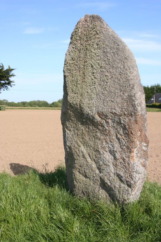
Menhir de Kerandrège submitted by JohnGinny on 9th Aug 2007. Kerandrège menhir.
(View photo, vote or add a comment)
Log Text: This menhir has lost its top, but is still about 3 metres high, 2 metres wide and has been nicely shaped, and is associated with the lovely allée couverte with which it stands just outside the entrance. It can be found in a field to the left of the D116 road to the south of Moelan-sur-Mer on the way to Brigneau.
Allée Couverte de Kergoustance
Trip No.203 Entry No.455 Date Added: 23rd May 2020
Site Type: Passage Grave
Country: France (Bretagne:Finistère (29))
Visited: Yes on 16th Jun 2005. My rating: Condition 4 Ambience 3 Access 4
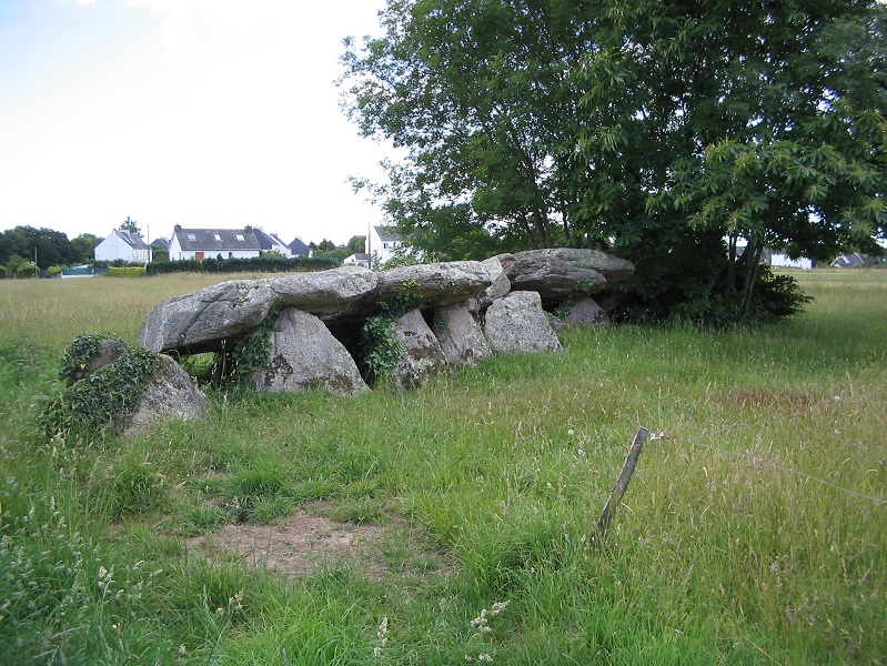
Allée Couverte de Kergoustance submitted by johnstone on 21st Mar 2019. The 17 metres of monument with tree, June 19, 2004
(View photo, vote or add a comment)
Log Text: This is a nice allée couverte which can be found in a field just to the right of the D.24 road as you head southwest out of Moelan-sur-Mer just at the limits of the village. The chamber is more than 15 metres in length, and has all seven capstones still in place, although a couple of them are broken. It is aligned on about 055°, but it is difficult to be precise because of the trees growing within it preventing me getting a good sightline for my compass. The stones consist of a nice pink granite, and is of the leaning side stone type construction. At the back end, the last section is blocked off with a crosswise slab.
Kernédiec allée couverte
Trip No.203 Entry No.456 Date Added: 23rd May 2020
Site Type: Passage Grave
Country: France (Bretagne:Finistère (29))
Visited: Yes on 16th Jun 2005. My rating: Condition 3 Ambience 3 Access 5
Kernédiec allée couverte submitted by richardhtc on 5th Sep 2006. Kernédiec allée couverte, Commune of Riec sur Belon, August 2006
(View photo, vote or add a comment)
Log Text: Kernédiec allée couverte is of the arc boutée type construction, and it is one of only eight of this type known. This is where one row of side stones leans up against the other and there are no capstones, rather than the more normal two rows of uprights and horizontal capstones. The chamber is about eight metres in length, and faces eastwards at 085°. The six stones on the northern side are set fairly vertically, while the seven on the southern side lean on to them.
This type of construction saves on stones, but makes a much smaller space inside the chamber. This monument is to be found in a little picnic area besides the road a few kilometres to the south of the village of Riec-sur-Belon, but its a fairly tortuous drive to get to it !
Allée Couverte de Coat Luzuen
Trip No.203 Entry No.457 Date Added: 23rd May 2020
Site Type: Passage Grave
Country: France (Bretagne:Finistère (29))
Visited: Yes on 16th Jun 2005. My rating: Condition 3 Ambience 3 Access 4
Allée couverte de Coat Luzuen submitted by greywether on 4th Jul 2005. This is a site which I did not know the name of, just the location. So I hope I have allocated the right name to it.
(View photo, vote or add a comment)
Log Text: Coat Luzuen allée couverte is situated in a field just to the west of the little road running north from the hamlet of Luzuen, and although signposted, it is quite difficult to find, with the last signpost being small and almost hidden, overgrown in a hedge opposite to a farm building.
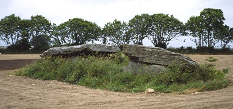
When I visited this I was not totally sure what it was I was visiting, I could not be sure whether it is the remains of a strangely shaped allée couverte, or perhaps two dolmens, both quite large and opening to the west. Although I know of this as an allée couverte, it is marked on some maps as two dolmens, and as far as I can ascertain from more research, it was a single large allée couverte which has had a section removed from its centre.
The western part of the two sections has a large chamber covered by a massive single capstone 7 metres long by 3 metres wide, and it is easy to stand up inside. The eastern part, which was possibly once joined as the two side walls line up, is not so large, and is only open to the west, in the direction of its neighbour, and has only two sidestones and an endstone, the other side having collapsed.
Ty Corriganet de Coat Menez Guen
Trip No.203 Entry No.458 Date Added: 23rd May 2020
Site Type: Passage Grave
Country: France (Bretagne:Finistère (29))
Visited: Yes on 16th Jun 2005. My rating: Condition 3 Ambience 3 Access 3

Ty Corriganet de Coat Menez Guen submitted by Ozzie on 8th Mar 2016. Ty Corriganet de Coat Menez is 1km past Allée Couverte de Coat Luzuen down a farm track, across a soggy ford and in a field on the left. It is quite overgrown. The Allée Couverte de Coat Luzuen photo has been incorrectly used for this monument in Megalithes de Bretagne.
(View photo, vote or add a comment)
Log Text: From the Coat Luzuen allée couverte, continue on about 800 metres further down the road which peters out into a trackway and descends to the bottom of the valley. Turn left at the bottom, cross the stream, go along the wet track and the Coat-Menez-Guen allée couverte is to be found at the end of the field. Unfortunately when I visited, it was completely inaccessible through a large crop of rape seed.
It is supposedly a superb monument, being a 14 metre long allée couverte of the arc boutée type with some capstones added for good measure. However, all I saw was the capstones ! It took me a lot of effort and time to get here, and unfortunately it was not worth the effort in this state. Its probably a good one to visit in February or something !
Menhir de Courégant
Trip No.203 Entry No.448 Date Added: 23rd May 2020
Site Type: Standing Stone (Menhir)
Country: France (Bretagne:Morbihan (56))
Visited: Yes on 16th Jun 2005. My rating: Condition 4 Ambience 2 Access 2
Menhir de Courégant submitted by TheCaptain on 11th Jan 2019. Courégant menhir is 5 metres tall, and can be found just outside the back of a holiday homes complex.
(View photo, vote or add a comment)
Log Text: Courégant menhir is 5 metres tall, and can be found just outside the back of a holiday homes complex. There is no obvious path through to it, but some people in one of the chalets let me take a picture from their decking ! Thanks to them !
Menhir de Kerroc'h (Ploemeur)
Trip No.203 Entry No.447 Date Added: 23rd May 2020
Site Type: Standing Stone (Menhir)
Country: France (Bretagne:Morbihan (56))
Visited: Yes on 16th Jun 2005. My rating: Condition 3 Ambience 3 Access 4
Menhir de Kerroc'h (Ploemeur) submitted by TheCaptain on 11th Jan 2019. Kerroc’h menhir is a small menhir, only about 1.7 metres tall
(View photo, vote or add a comment)
Log Text: Kerroc’h menhir is a small menhir, only about 1.7 metres tall, that initially looks impossible to get to through the gorse. However, there is a footpath to it from beside the houses, and it comes complete with a little sign.
Menhirs de Hirguer
Trip No.203 Entry No.450 Date Added: 23rd May 2020
Site Type: Standing Stones
Country: France (Bretagne:Finistère (29))
Visited: Saw from a distance on 16th Jun 2005
Menhirs de Hirguer submitted by TheCaptain on 12th Jan 2019. A few hundred metres to the south of the road to Clohars from Moelan can be seen this menhir which must be about 3 metres tall.
(View photo, vote or add a comment)
Log Text: A few hundred metres to the south of the road to Clohars from Moelan, bit further to the east along the road from the above menhir, can be seen this menhir which must be about 3 metres tall.
Menhir de Mescléo A
Trip No.203 Entry No.449 Date Added: 23rd May 2020
Site Type: Standing Stone (Menhir)
Country: France (Bretagne:Finistère (29))
Visited: Yes on 16th Jun 2005. My rating: Condition 2 Ambience 2 Access 5
Menhir de Mescléo A submitted by TheCaptain on 12th Jan 2019. This is a 2 metre tall menhir right beside the road between Moelan and Clohars. There is another stone beside it - perhaps a broken top ?
(View photo, vote or add a comment)
Log Text: This is a 2 metre tall menhir right beside the surprisingly busy road between Moelan and Clohars. There is another stone beside it - perhaps a broken top ?
Mentoul Menhir
Trip No.203 Entry No.452 Date Added: 23rd May 2020
Site Type: Standing Stone (Menhir)
Country: France (Bretagne:Finistère (29))
Visited: Yes on 16th Jun 2005. My rating: Condition 3 Ambience 3 Access 5
Mentoul Menhir submitted by TheCaptain on 12th Jan 2019. This menhir is found in a little grassy area just to the north of Moelan-sur-Mer town centre, between the houses.
(View photo, vote or add a comment)
Log Text: This menhir is found in a little grassy area just to the north of the town centre, between the houses. Its about 3 metres high and 2 metres wide.
Bellevue Menhir
Trip No.203 Entry No.451 Date Added: 23rd May 2020
Site Type: Standing Stone (Menhir)
Country: France (Bretagne:Finistère (29))
Visited: Yes on 16th Jun 2005. My rating: Condition 4 Ambience 2 Access 5
Bellevue menhir submitted by thecaptain on 13th Jul 2006. This menhir is more than 4 metres tall, right beside the old Roman road to the south of the town centre.
(View photo, vote or add a comment)
Log Text: Bellevue menhir near to the town of Moëlan-sur-Mer is more than 4 metres tall, right beside the old Roman road to the south of the town centre. I found it difficult to park nearby and get a reasonable picture in between dodging all the traffic on this busy road.
Goërem Dolmen
Trip No.203 Entry No.445 Date Added: 23rd May 2020
Site Type: Chambered Tomb
Country: France (Bretagne:Morbihan (56))
Visited: Yes on 16th Jun 2005. My rating: Condition 3 Ambience 3 Access 4
Goërem dolmen submitted by TheCaptain on 17th Jun 2011. Its not a very big mound, just a big enough barrow to cover the passage grave, which is about 20 metres by 10 metres, and up to 3 metres in height maximum
(View photo, vote or add a comment)
Log Text: I came all the way out to this poor depressed village at the end of a long peninsula and stayed the night on the harbourside in order to visit this, "the finest angled passage grave in existance". Take a good torch it says. So on a nasty dull grey day I walk round the seafront and through the village till I eventually find it. It is right on the western seafront, in amongst the houses, and has a reasonable amount of land reserved around it. It would probably have a spectacular view if there was one to be seen through all the murk.
Its not a very big mound, just a big enough barrow to cover the passage grave, which is about 20 metres by 10 metres, and up to 3 metres in height maximum, perhaps more originally as the modern ground level is probably higher than it was, particularly with the sea wall here. The entrance is on the south side, but it's gated up, with an iron gate concreted in to the ground, so despite having two torches, I cannot enter and put them to use. But I have to say, that it's no doubt for the best, as the place is littered with broken bottles and other rubbish, with graffitti sprayed everywhere, and badly smelling of a toilet block. This poor little town is clearly suffering from a lack of jobs and investment, and seems to have a bit of a problem with bored youth compared to much of the rest of France. Its a great shame, as I was really looking forward to seeing this place properly. I would like to think that the excellent state of the internal structure is still as it was a few years ago, and that the engraved pillars of the passageway are still in good condition.
Menhir de Goulvars
Trip No.203 Entry No.429 Date Added: 23rd May 2020
Site Type: Standing Stone (Menhir)
Country: France (Bretagne:Morbihan (56))
Visited: Yes on 15th Jun 2005. My rating: Condition 5 Ambience 2 Access 4

Menhir de Goulvars submitted by ermine on 8th Aug 2004. This 4m tall granite menhir stands near the Conguel campsite and the Quiberon aerodrome - it extends another 1m into the ground, according to the information board
(View photo, vote or add a comment)
Log Text: This massive menhir is now sadly fenced in behind the SNCF holiday complex near to Pointe du Conguel out at the tip of the Quiberon peninsular. It can be found by taking the road beside the SNCF complex until it reaches the grassland behind them, and then taking the trackway to the left. The menhir is hidden behind some large trees and a hedge, and it took me two visits before I found it, my previous visit having taken the wrong track. It really is a lovely stone, well over 5 metres tall and 2 metres in width, and it has been shaped and smoothed. Finding this was a good start to a grotty looking day.
Rondossec Dolmens
Trip No.203 Entry No.432 Date Added: 23rd May 2020
Site Type: Burial Chamber or Dolmen
Country: France (Bretagne:Morbihan (56))
Visited: Yes on 15th Jun 2005. My rating: Condition 5 Ambience 3 Access 5

Rondossec dolmens submitted by JJ on 9th Nov 2002. Rondossec dolmens
(View photo, vote or add a comment)
Log Text: This is a remarkably complete monument with three passage dolmens facing eastwards contained within a 20 metre diameter cairn, right near to the centre of the village.
The southernmost chamber is the smallest, a collapsed oval chamber of about 3 m by 2 m with a 5 metre long corridor leading to it, which is still mostly covered. The central chamber is one of those widening of the corridor types, up to 3 metres wide at the back and 5 metres in length, with a 6 metre long corridor. It is all still mostly covered, with two large capstones over the massive chamber.
The northern chamber is rectangular 4 m by 3 m with a 10 metre long entry passageway. It also has a small 2 m by 1 m side chamber off of its southern side, which is very unusual. Although one capstone is missing, the rest are still mostly in place. The two large chambers are high enough to stand up in. This monument had a steady stream of visitors while I was there.
Vieux-Moulin Alignement
Trip No.203 Entry No.433 Date Added: 23rd May 2020
Site Type: Stone Row / Alignment
Country: France (Bretagne:Morbihan (56))
Visited: Yes on 15th Jun 2005. My rating: Condition 4 Ambience 4 Access 4

Vieux-Moulin alignement submitted by JJ on 9th Nov 2002. Vieux-Moulin alignement
(View photo, vote or add a comment)
Log Text: This is a nice little row of 6 menhirs, up to 4 metres in height, standing on the slopes of a field just near to the busy D.781 Carnac to Erdeven road, just to the north of Plouharnel station. These are nicely shaped and positioned stones.
