

<< Our Photo Pages >> Pors Poulhan allée couverte - Passage Grave in France in Bretagne:Finistère (29)
Submitted by TheCaptain on Saturday, 16 May 2009 Page Views: 13493
Neolithic and Bronze AgeSite Name: Pors Poulhan allée couverte Alternative Name: Menez KorrigedCountry: France Département: Bretagne:Finistère (29) Type: Passage Grave
Nearest Town: Quimper Nearest Village: Plouhinec
Latitude: 47.986300N Longitude: 4.4656W
Condition:
| 5 | Perfect |
| 4 | Almost Perfect |
| 3 | Reasonable but with some damage |
| 2 | Ruined but still recognisable as an ancient site |
| 1 | Pretty much destroyed, possibly visible as crop marks |
| 0 | No data. |
| -1 | Completely destroyed |
| 5 | Superb |
| 4 | Good |
| 3 | Ordinary |
| 2 | Not Good |
| 1 | Awful |
| 0 | No data. |
| 5 | Can be driven to, probably with disabled access |
| 4 | Short walk on a footpath |
| 3 | Requiring a bit more of a walk |
| 2 | A long walk |
| 1 | In the middle of nowhere, a nightmare to find |
| 0 | No data. |
| 5 | co-ordinates taken by GPS or official recorded co-ordinates |
| 4 | co-ordinates scaled from a detailed map |
| 3 | co-ordinates scaled from a bad map |
| 2 | co-ordinates of the nearest village |
| 1 | co-ordinates of the nearest town |
| 0 | no data |
Internal Links:
External Links:
I have visited· I would like to visit
Jimwithnoname 43559959 PAB postvmvs would like to visit
bishop_pam visited on 8th Aug 2019 - their rating: Cond: 4 Amb: 5 Access: 5
rrmoser visited on 5th Jun 2017 - their rating: Cond: 4 Amb: 4 Access: 5
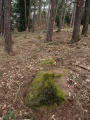
TheCaptain visited on 17th Jun 2005 - their rating: Cond: 5 Amb: 4 Access: 5 On a headland overlooking the Baie D'Audierne, this allée couverte is in a tremendous position. The 12 metre long passage is quite large and wide at almost 2 metres in width, and almost as high, and lines up to the east at 100°.
Built before the year 3000BC, it has been used almost continually for one purpose or another until the present day. Excavations have shown it to have not only been constructed and used by neolithic flint workers, but also for burials in the bronze age, iron age, and by the Gallo-Romans. In the middle ages it was used as a quarry for building stone, and since then it has been used as a military look out post, and as such was blown up during the second world war.
Restoration was made in about 1990, with it now in a nicely kept little grassy area with benches and an information board. Two capstones are in place, as is a lot of floor paving, but the unusual thing for around here is that it still has many of the stones from its surrounding peristalith. This is a nice place to sit and ponder.
johnstone visited on 14th Jun 2004 - their rating: Cond: 4 Amb: 5 Access: 5
regina neolithique02 DrewParsons paulcall have visited here
Average ratings for this site from all visit loggers: Condition: 4.25 Ambience: 4.5 Access: 5
")
Built before the year 3000BC, it has been used almost continually for one purpose or another until the present day. Excavations have shown it to have not only been constructed and used by neolithic flint workers, but also for burials in the bronze age, iron age, and by the Gallo-Romans.
In the middle ages it was used as a quarry for building stone, and since then it has been used as a military look out post, and as such was blown up during the second world war.
Restoration was made in about 1990, with it now in a nicely kept little grassy area with benches and an information board. Two capstones are in place, as is a lot of floor paving, but the unusual thing for around here is that it still has many of the stones from its surrounding peristalith.
This is a nice place to sit and ponder.
See for more pictures and description: T4T35 Mégalithes du Monde
You may be viewing yesterday's version of this page. To see the most up to date information please register for a free account.
")
")
")
")
")
")
")
")
")
")
")
")
")
")
")
")
")
")
")
")
")
")
Do not use the above information on other web sites or publications without permission of the contributor.
Click here to see more info for this site
Nearby sites
Click here to view sites on an interactive map of the areaKey: Red: member's photo, Blue: 3rd party photo, Yellow: other image, Green: no photo - please go there and take one, Grey: site destroyed
Download sites to:
KML (Google Earth)
GPX (GPS waypoints)
CSV (Garmin/Navman)
CSV (Excel)
To unlock full downloads you need to sign up as a Contributory Member. Otherwise downloads are limited to 50 sites.
Turn off the page maps and other distractions
Nearby sites listing. In the following links * = Image available
130m ESE 106° Dolmen De Pors Poulhan* Burial Chamber or Dolmen
665m W 267° Grotte de Menez Dregan* Cave or Rock Shelter
668m W 278° Cairn de Menez Dregan * Chambered Cairn
694m WNW 291° Dolmens de Menez Dregan 2* Burial Chamber or Dolmen
2.9km E 90° Face au Penker menhir* Standing Stone (Menhir)
2.9km E 91° Menhir de Plozevet* Standing Stone (Menhir)
4.0km SE 129° Menhir des Droits de l'Homme* Standing Stone (Menhir)
4.8km NW 305° Saint-Dreyel mégalithe Standing Stone (Menhir)
5.4km E 101° Menhir de Lestrouquy* Standing Stone (Menhir)
6.2km E 101° Menhir de Kervinou (Plozévet) Standing Stone (Menhir)
7.0km ESE 104° Menhirs de Kerdelec* Standing Stone (Menhir)
8.5km SE 137° Corn-ar-Palud* Chambered Cairn
8.7km ESE 115° Peulven menhir (Pouldreuzic) Standing Stone (Menhir)
8.7km SE 133° Crugou et Renongar* Chambered Tomb
9.7km ESE 114° Menhir de Kersourou Standing Stone (Menhir)
9.7km E 97° Lesvoe menhir Standing Stone (Menhir)
9.8km ESE 113° Allée Couverte de Plovan Passage Grave
9.8km NNE 28° Dolmen de la Chapelle de Kerinec* Burial Chamber or Dolmen
9.9km NNE 28° Menhir de la Chapelle de Kerinec* Standing Stone (Menhir)
10.0km ESE 110° Menhir de Kerglogé 1* Standing Stone (Menhir)
10.0km ESE 110° Menhir de Kerglogé 2* Standing Stone (Menhir)
10.1km ESE 110° Menez Roz Tuchic menhir Standing Stone (Menhir)
10.2km ESE 114° Saint-Kodelig menhir* Standing Stone (Menhir)
10.2km WNW 293° St. Tugen holy well* Holy Well or Sacred Spring
10.4km ESE 108° Menhir de Kerguelven Standing Stone (Menhir)
View more nearby sites and additional images


 We would like to know more about this location. Please feel free to add a brief description and any relevant information in your own language.
 Wir möchten mehr über diese Stätte erfahren. Bitte zögern Sie nicht, eine kurze Beschreibung und relevante Informationen in Deutsch hinzuzufügen.
 Nous aimerions en savoir encore un peu sur les lieux. S'il vous plaît n'hesitez pas à ajouter une courte description et tous les renseignements pertinents dans votre propre langue.
 Quisieramos informarnos un poco más de las lugares. No dude en añadir una breve descripción y otros datos relevantes en su propio idioma.