Contributory members are able to log private notes and comments about each site
Sites markj99 has logged. View this log as a table or view the most recent logs from everyone
Court Cairn, The May
Date Added: 13th Jul 2025
Site Type: Cairn
Country: Scotland (Dumfries and Galloway)
Visited: Yes on 27th Sep 2020. My rating: Condition 1 Ambience 3 Access 3
Court Cairn, The May submitted by markj99 on 4th Oct 2020. Court Cairn, The May in situ.
(View photo, vote or add a comment)
Log Text: Directions to Court Cairn (The May): Take the A747 Port William turn off the A75 at Glenluce. Stay on the A747 for c. 6.6 miles to an unsigned left turn onto the B7005 at NX 27136 49953. Travel on the B7005 for c. 2.2 miles to reach a minor road signed for Kirkcowan. Court Cairn (The May) is 0.4 miles on the left at The May farm. There is room to park in a gateway adjacent to the field.
Cosdon Hill Multiple Stone Rows
Date Added: 13th Jul 2025
Site Type: Multiple Stone Rows / Avenue
Country: England (Devon)
Visited: Yes on 31st Aug 2020. My rating: Condition 3 Ambience 5 Access 2
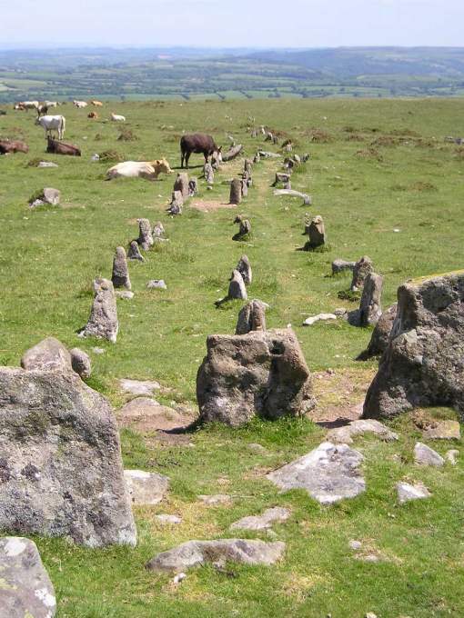
Cosdon Hill Multiple Stone Rows submitted by TheCaptain on 10th Jun 2004. Cosdon Hill Multiple Stone Rows, Dartmoor, Devon SX643917
The three parallel rows run off down the hillside from the cairn in an easterly direction, for a distance of at least 140 metres. Each of the rows has a large slab placed across the rows at its end by the cairn. The rows are not straight, and curve slightly south and then to the north down the hill.
A smashing place to while away some time.
(View photo, vote or add a comment)
Log Text: It is quite a steep walk up Cosdon Hill to this outstanding triple stone row. The stones are not very tall but this impressive monument is well worth a visit. The cairn at the W end is ruined but there are remains of a double cist in the centre.
Cosdon Hill Cairn Circle
Date Added: 13th Jul 2025
Site Type: Stone Circle
Country: England (Devon)
Visited: Yes on 31st Aug 2020. My rating: Condition 3 Ambience 5 Access 2
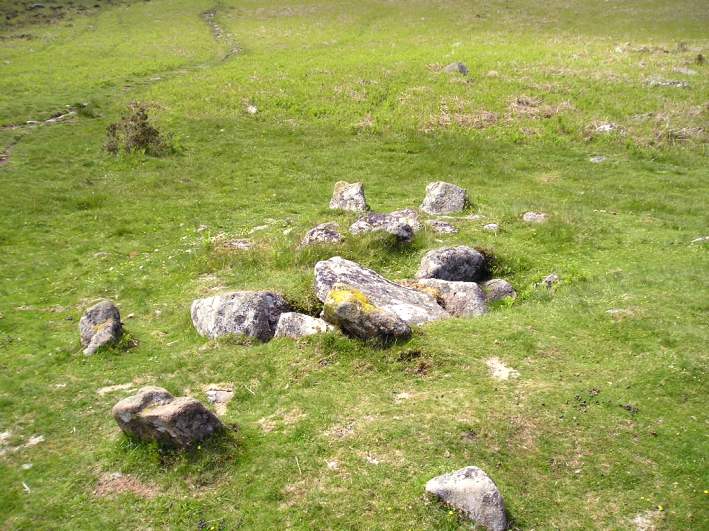
Cosdon Hill Cairn Circle submitted by TheCaptain on 10th Jun 2004. Cosdon Hill Cairn Circle, Dartmoor, Devon SX643916
On a flatter shelf of land on the eastern side of Cosdon Hill are the splendid remains of a cairn and treble stone row.
The remains of the cairn at the uphill end of the rows is approx 8 metres in diameter, and has been substantially messed about with. Despite this, there are the clear remains of a double cist in the centre of the cairn, the downhill one of which still has its capstone largely in place. Several stones also remain in place...
(View photo, vote or add a comment)
Log Text: It is quite a steep walk up Cosdon Hill to this outstanding triple stone row. The stones are not very tall but this impressive monument is well worth a visit. The cairn at the W end is ruined but there are remains of a double cist in the centre.
Corrimony
Date Added: 11th Jul 2025
Site Type: Clava Cairn
Country: Scotland (Highlands)
Visited: Yes on 3rd May 2006. My rating: Condition 3 Ambience 4 Access 4
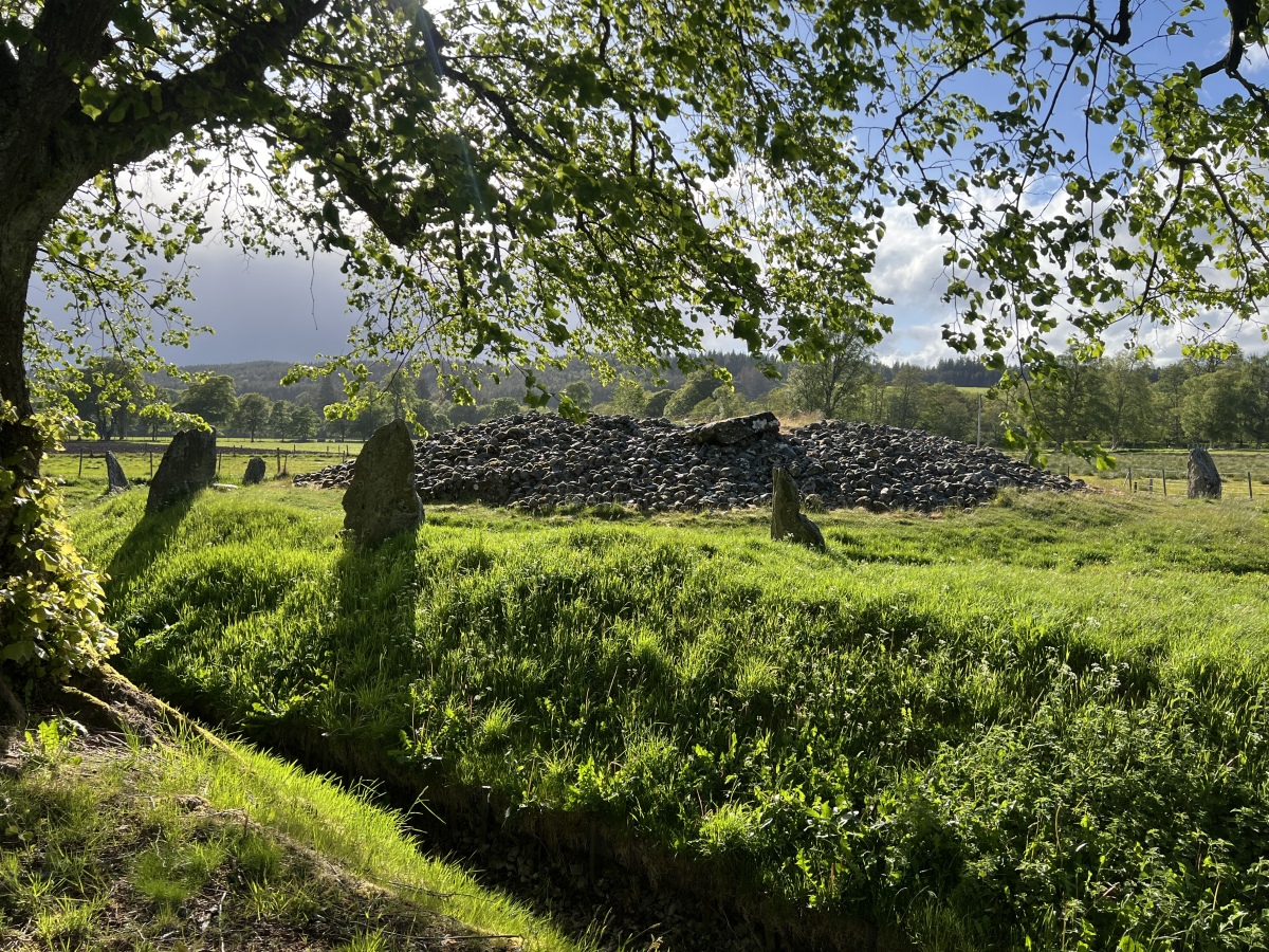
Corrimony submitted by Amouquesoy on 22nd Jun 2025. Taken from the entrance of the site (May 27th 2025 in the evening)
(View photo, vote or add a comment)
Log Text: Corrimony Clava Cairn has been excavated at least twice: first in 1830, then again in 1952. The central chamber was covered in 1830 but it is now open to the sky. Trove.scot Place 12256 states that 4 of the 11 outer stones are modern additions and 2 stones have been reset in modern times. With all this interference there is some doubt as to the authenticity of the clava cairn in its current form.
Cork Stone
Date Added: 10th Jul 2025
Site Type: Natural Stone / Erratic / Other Natural Feature
Country: England (Derbyshire)
Visited: Yes on 22nd Jan 2009. My rating: Condition 3 Ambience 4 Access 3

Cork Stone submitted by Vicky on 13th Nov 2001. The Cork Stone, Stanton Moor, Derbyshire GR: SK245628
The Cork Stone is one of a number of impressive natural outcrops on Stanton Moor. Composed of weathered sandstone it resembles a huge mushroom or cork. As with the Andle Stone nearby it is covered in graffiti from the 19th and 20th centuries and has steps carved into the side to allow access to the top.
(View photo, vote or add a comment)
Log Text: Additions to a site are normally detrimental however the steps and iron rungs added to the Cork Stone are an exception. The base of the stone is sturdy enough to allow people (myself included) to climb onto the top. There is a round rock basin on the flat top of the Cork Stone.
Condolden Barrow
Date Added: 10th Jul 2025
Site Type: Round Barrow(s)
Country: England (Cornwall)
Visited: Yes on 5th Jun 2023. My rating: Condition 3 Ambience 4 Access 4

Condolden Barrow submitted by thecaptain on 17th Nov 2008. Legend claims this to be the final resting place of Cador, a 6th century King of Cornwall and one of Arthur's knights.
Viewed here from the east
(View photo, vote or add a comment)
Log Text: I visited Condolden Barrow in an unusually dry spell: the mound was badly eroded especially on the summit.
Concraig
Date Added: 10th Jul 2025
Site Type: Standing Stone (Menhir)
Country: Scotland (Perth and Kinross)
Visited: Yes on 30th Nov 2018. My rating: Condition 4 Ambience 4 Access 3

Concraig submitted by Nick on 30th Mar 2013. Looking north west
(View photo, vote or add a comment)
Log Text: I was fortunate to visit Concraig Standing Stone in November when the field was not in crop so was able to get a close view of this handsome standing stone.
Comet Stone (Orkney)
Date Added: 9th Jul 2025
Site Type: Standing Stone (Menhir)
Country: Scotland (Orkney)
Visited: Yes on 7th Aug 2012
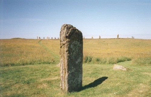
Comet Stone (Orkney) submitted by steveco on 24th Feb 2002. Comet Stone HY296132 standing 137mtrs SE from the Ring of Brodgar.
(View photo, vote or add a comment)
Log Text: The Comet Stone is an intriguing site to visit because of its proximity to the Ring of Brodgar. It seems likely it had some relationship to the stone circle. The stone stumps on the mound add an extra layer of mystery.
Cardinham Moor row
Date Added: 9th Jul 2025
Site Type: Stone Row / Alignment
Country: England (Cornwall)
Visited: Yes on 18th Mar 2014

Cardinham Moor row submitted by TheCaptain on 16th Jul 2022. Cardinham Moor row stone 4 as per the published plan.
Looking south, stones 1 and 3 can be seen. Also the further stone up on the hillside in the original photo
(View photo, vote or add a comment)
Log Text: I was able to find 10 stones in Cardinham Moor row by locating the standing stone on the NW end of the row then walking NW. I found 4 standing stones and 6 recumbent stones.
Colquite Menhir
Date Added: 9th Jul 2025
Site Type: Standing Stone (Menhir)
Country: England (Cornwall)
Visited: Yes on 11th Apr 2018
Colquite Menhir submitted by TheCaptain on 7th Dec 2010. The stone is nearly 6 feet tall in a little enclosure type area where the walls go around it, which would seem unusual for many reasons.
(View photo, vote or add a comment)
Log Text: I passed by Colquite Standing Stone on the way to East Moor Cairns and Nine Stones of Altarnun. It certainly appears to be an ancient stone repurposed as a gate stone at one point. The fact that the stone wall detours around it emphasises its significance.
Colmeallie
Date Added: 8th Jul 2025
Site Type: Stone Circle
Country: Scotland (Angus)
Visited: Yes on 19th Nov 2019. My rating: Condition 2 Ambience 4 Access 4
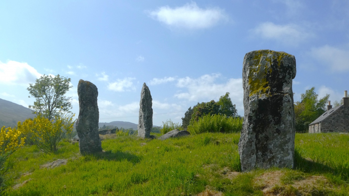
Colmeallie submitted by PeteCrane5 on 31st Dec 2023. "A stunning location" ... "A classic, if rather mauled recumbent stone circle" .. looking back at 2023 Colmeallie in the GlenEsk is one of my favourites
(View photo, vote or add a comment)
Log Text: The three standing stones on the SE arc of the stone circle give a sense of scale and structure to the jumbled remains of this monument.
Grand Menhir de Counozouls
Date Added: 8th Jul 2025
Site Type: Standing Stone (Menhir)
Country: France (Languedoc:Aude (11))
Visited: Yes on 23rd Sep 2007. My rating: Condition 5 Ambience 4 Access 4
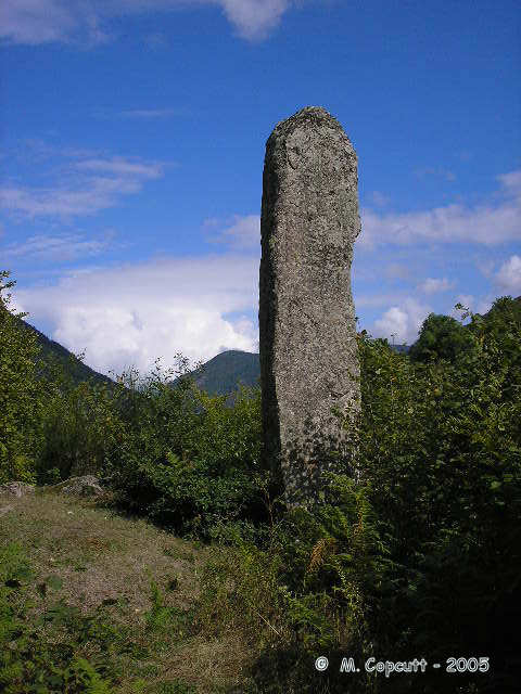
Grand Menhir de Counozouls submitted by thecaptain on 15th Nov 2005. Le Grand Menhir de Counozouls, at nearly 9 metres high, one of the tallest in France, stands on the side of a steep valley in the Pyrenees.
(View photo, vote or add a comment)
Log Text: I was based in Mosset for a French Holiday. After an ascent of the Col de Jau I continued along the D84 randomly. There was a sign for the Grand Menhir de Counozouls by the roadside. The massive standing stone was an unexpected surprise.
Coille A'chnoic Mhoir
Date Added: 7th Jul 2025
Site Type: Standing Stone (Menhir)
Country: Scotland (Isle of Islay)
Visited: Yes on 22nd Aug 2019
Coille A'chnoic Mhoir submitted by markj99 on 3rd Sep 2019. Looking back to Kintra campsite from Coille A'chnoic Mhoir.
(View photo, vote or add a comment)
Log Text: There are two strikes against Coille A'chnoic Mhoir Standing Stone: its name is hard to spell and difficult to pronounce. On the plus side it has fantastic views and is accessible from the path to Frachdale Chambered Cairn.
Coffin Stone (Glenluce)
Date Added: 7th Jul 2025
Site Type: Natural Stone / Erratic / Other Natural Feature
Country: Scotland (Dumfries and Galloway)
Visited: Yes on 15th Mar 2020

Coffin Stone (Glenluce) submitted by markj99 on 12th May 2021. Coffin Stone (Glenluce) viewed from W.
(View photo, vote or add a comment)
Log Text: The Coffin Stone was once adjacent to the A75 but the section of road in now disused. The stone is located on the W edge of marshy ground N of the road. There are precise directions on the main page.
Cnocan nan Gobhar
Date Added: 6th Jul 2025
Site Type: Round Cairn
Country: Scotland (Isle of Skye)
Visited: Yes on 11th Aug 2011
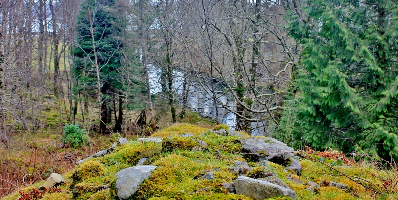
Cnocan nan Gobhar submitted by SumDoood on 3rd Mar 2016. Assuming trees had been removed, the cairn would have been very visible to anyone entering the bay by boat
(View photo, vote or add a comment)
Log Text: If you are going to visit Dun Ringill it is easy to take a c. 400 yard detour N to Cnocan nan Gobhar Cairn. There is an small exposed cist high up on the SW arc of the grassy mound. When I visited there was significant fern cover on the W arc of the cairn but the cist was clear of vegetation. I have added a route to Cnocan nan Gobhar Cairn on the main page.
Ullinish Lodge
Date Added: 6th Jul 2025
Site Type: Chambered Cairn
Country: Scotland (Isle of Skye)
Visited: Yes on 29th Apr 2010. My rating: Condition 2 Ambience 4 Access 4
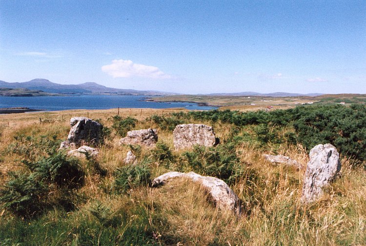
Ullinish Lodge submitted by Andy B on 24th Nov 2010. Taken in about 1997
(View photo, vote or add a comment)
Log Text: The remains of a large chamber are located close to the road in Ullinish. The chamber runs ESE-WNW, defined by 5 surviving stones.
Cnoc Nan Dursainean
Date Added: 6th Jul 2025
Site Type: Cairn
Country: Scotland (Isle of Lewis)
Visited: Yes on 4th Jul 2011. My rating: Condition 3 Ambience 4 Access 3
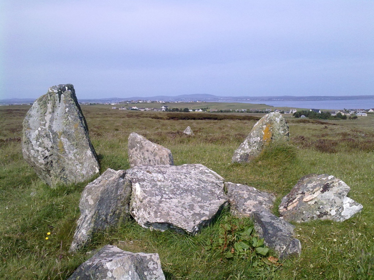
Cnoc Nan Dursainean submitted by markj99 on 5th Jul 2021. Cnoc Nan Dursainean Chamber viewed from SE, looking towards Garrabost.
(View photo, vote or add a comment)
Log Text: A walk into open moorland is required to visit Cnoc Nan Dursainean Cairn. It is possible to combine this with a visit to Clach Glas Standing Stone which is signposted off the A866. Directions are posted on the main page.
Garrabost
Date Added: 6th Jul 2025
Site Type: Standing Stone (Menhir)
Country: Scotland (Isle of Lewis)
Visited: Yes on 4th Jul 2011. My rating: Condition 4 Ambience 4 Access 4
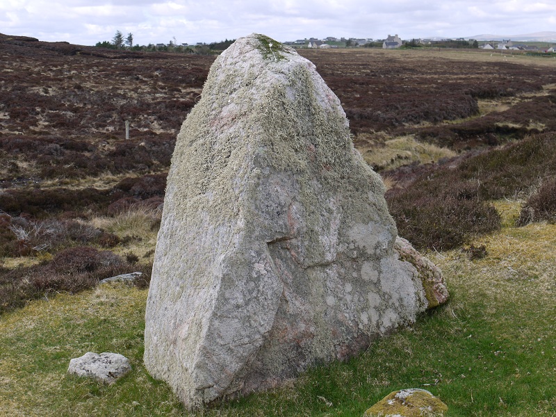
Garrabost submitted by SHUGS on 28th Sep 2015. Looking towards Garrabost
(View photo, vote or add a comment)
Log Text: It is easy to park in the Church Car Park on the W end of Garrabost. Walk S up the narrow road to a dead end. A path from here heads SE into moorland leading to an impressive triangular standing stone on a mound. The path continues through rough moorland to Cnoc Nan Dursainean Chambered Cairn. I have posted directions on the main page.
Na Tri Sithean
Date Added: 5th Jul 2025
Site Type: Chambered Cairn
Country: Scotland (Caithness)
Visited: Yes on 4th Sep 2021. My rating: Condition 3 Ambience 5 Access 4
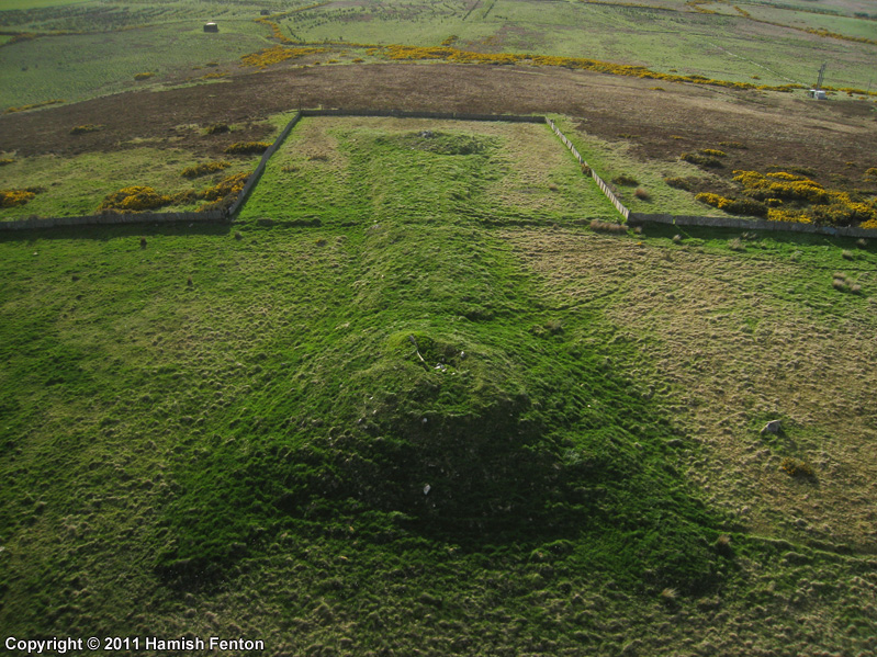
Na Tri Sithean submitted by h_fenton on 18th Aug 2011. Na Tri Sithean - chambered long horned cairn dating from the Neolithic, this particular cairn is one of the largest and the best preserved of its type. It measures 32m long, 9.7 metres wide and 1.2 metres high. The ends of the cairn grow into large mounds, the larger mound at the southeast end is 21.3metres wide and 3 metres high, the smaller mound at the northwestern end is 18 metres wide and 2.1metres high.
Kite Aerial Photograph taken from the southeast.
10 May 2011
(View photo, vote or add a comment)
Log Text: Na Tri Sithean Long Cairn is easily visited from a dedicated car park off the single track road between Shebster and Skiall. An uphill path leads to a pair of long cairns. The N long cairn, Cnoc Freiceadain runs from SW to NE, with a round terminal cairn on the SW end. Na Tri Sithean long cairn starts c. 100 yards SSW at a terminal cairn. It runs ESE-WSW.
Cnoc Freiceadain
Date Added: 5th Jul 2025
Site Type: Chambered Cairn
Country: Scotland (Caithness)
Visited: Yes on 4th Sep 2021. My rating: Condition 3 Ambience 5 Access 4
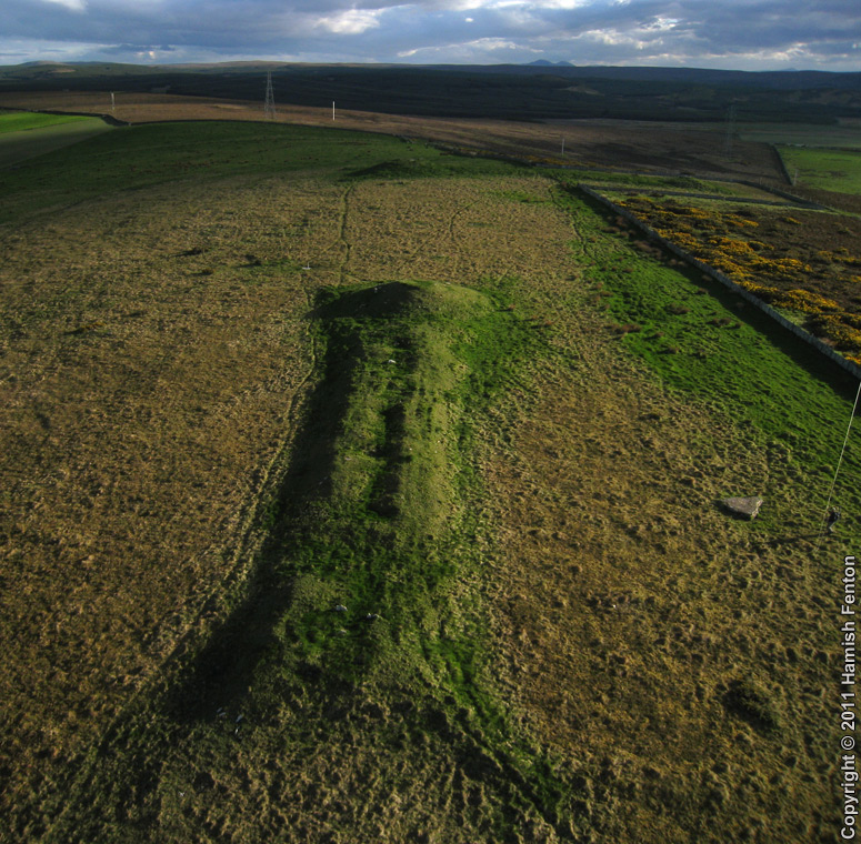
Cnoc Freiceadain submitted by h_fenton on 18th Aug 2011. Cnoc Freiceadain - chambered long horned cairn, dating from the Neolithic.
Kite Aerial Photograph taken roughly north. just in cloud shadow a short distance beyond the far end of this cairn is Na Tri Sithean cairn which is slightly larger and better preserved.
10 May 2011
(View photo, vote or add a comment)
Log Text: Cnoc Freiceadain Long Cairn is easily visited from a dedicated car park off the single track road between Shebster and Skiall. An uphill path leads to a pair of long cairns. The N long cairn, Cnoc Freiceadain runs from SW to NE, with a round terminal cairn on the SW end. Na Tri Sithean long cairn starts c. 100 yards SSW at a terminal cairn. It runs ESE-WSW.
