


Contributory members are able to log private notes and comments about each site
Sites TheCaptain has logged on trip number: 210 (View all trips)
View this log as a table or view the most recent logs from everyone
Bringnerault Alignement
Trip No.210 Entry No.1 Date Added: 18th Aug 2026
Site Type: Standing Stones
Country: France (Bretagne:Ille-et-Vilaine (35))
Visited: Yes on 3rd Jun 2010. My rating: Condition 3 Ambience 3 Access 4
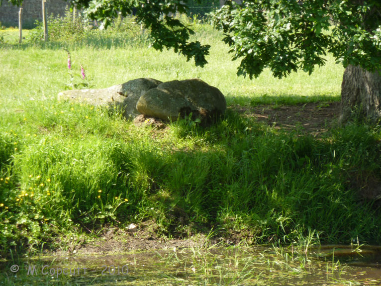
Bringnerault alignement submitted by TheCaptain on 17th Jul 2010. Further to the south of stone No.3 is now a pond, on the far side of which is a large stone, 2 metres plus in length.
(View photo, vote or add a comment)
Log Text: Before I visited, the information I had about this site was as follows. Three menhirs fallen or leaning, in a north to south line, 2 km east of Hedé. No.1 is 3.2m tall and fallen; 8m south of this is No.2, 2.2m long; 90m further south is No.3, 2m tall, fallen, with a V carved on the summit. Previously recorded, but missing, are No.4, several m west of No.1, 2.4m long, and No.5 close to 4, 1.6m long. What I found was slightly different. In an open field beside a little lane running south from the D.22 to Bringnerault, can be seen a couple of standing stones. I was expecting 3 menhirs in a north – south line, of which only one is standing, but I found much more in this granite landscape. Pretty much as per description, I found stone No.1 is indeed 3.2 metres long and fallen, with stone No.2 2.2 m tall leaning, but standing about 8 metres south of No.1. Stone No.3 is indeed about 90 metres south of No.2, but it is more than 2 metres tall and standing. I could see no carvings in its top, but it looked like the top was broken off and laying at the foot of No.3. I also found another stone, which I shall call stone no.6, at least 1.5 metres long, fallen and mostly buried about 50 metres north of stone No.1, and in alignment with the other three. Also, less than 10 metres north of stone No.3 in the alignement, is visible the top of a stone, maybe a stump of a previous stone in the alignment. Further to the south of stone No.3 is now a pond, and around this pond are placed bits and pieces of other stones, maybe broken pieces of stones from the alignement. On the far side of the pond, about 80 metres south of No.3 and in alignment with the other stones, is a large stone, 2 metres plus in length. I would expect that here was once a much more substantial alignement of menhirs. If I had a lot more time, I have no doubt that other stones could be found under the long grass and other growth within this field.
Roche-aux-Fées (Essé)
Trip No.210 Entry No.2 Date Added: 16th Sep 2020
Site Type: Passage Grave
Country: France (Bretagne:Ille-et-Vilaine (35))
Visited: Yes on 3rd Jun 2010. My rating: Condition 5 Ambience 5 Access 5
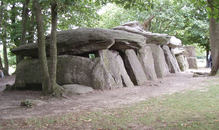
Roche-aux-Fées (Essé) submitted by AlexHunger on 21st Sep 2004. Roches Aux Fees viewed from North West
(View photo, vote or add a comment)
Log Text: June 2010 visit to France to see my sister, and as usual I had my Dad with me. I had decided on a long detour to visit La Roche-aux-Fées, but before we came here, I had told him nothing about it, except to say we were going to visit somewhere special. He is well used to me taking him to old stones all over the place, often on wild goose chases in woods and across fields finding nothing. But not this time.
This monument is now presented quite differently to when I previously visited in 2005, with a large new car park and visitor centre in what would have been fields to the south. Unfortunately, the visitor centre was closed, being open at weekends and holidays only this time of year until July and August when it becomes daily. I have read that this centre is very good, and with a decent book and gift shop.
From the visitor centre, a pathway leads through a nicely landscaped area towards the monument itself, which is hidden behind trees and hedges, until you round the end of a hedge (with a large fallen stone at the corner), and then there it is, in all its splendor, viewed towards the wonderful portal entrance. Even on my second visit here, it is awe inspiring, especially the work on the portico, which is over 4500 years old and still completely level.
My Dad was well impressed too, and couldn’t quite believe what he was seeing. “Oh My!, How can this be so big? What’s this for?” he asked. “It can’t be just to bury somebody in. All these separate room bits? Why? It’s a bit like the side chapels in a Cathedral”. Pretty much my thoughts exactly, and it is good to hear these things coming from somebody else with no prompting.
Somebody had made little piles of pebbles and other decorative bits and pieces placed at various places, which looked good. I am impressed by one of the massive capstones which seems to have been fitted exactly into a gap in the supporting side stones. This place is truly absolutely fantastic. I don’t have the words for it.
The new field around the monument has been splendidly done, and gives it the space it needs. Only two other people came to visit in the time we were here, a large improvement over my previous August Saturday visit. One downside are the various noticeboards now erected here, stating that cracks have been found in some of the stones, and people should be careful and not climb on the stones. I hope that there is no bad damage to the place. What would the Fairies think?
Pierre Blanche (Pocé-les-Bois)
Trip No.210 Entry No.3 Date Added: 18th Aug 2026
Site Type: Standing Stone (Menhir)
Country: France (Bretagne:Ille-et-Vilaine (35))
Visited: Yes on 3rd Jun 2010. My rating: Condition 4 Ambience 3 Access 4
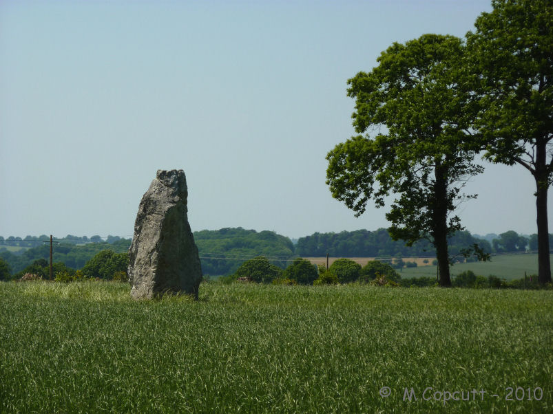
Pierre Blanche (Pocé-les-Bois) submitted by TheCaptain on 29th Jun 2010. The Pierre Blanche of Pocé-les-Bois, south of Vitré, is a nice 4 metre tall menhir. It has a nice pointy top, and I wouldn’t be surprised if it has been hit and broken by lightning on occasion.
(View photo, vote or add a comment)
Log Text: The Pierre Blanche of Pocé-les-Bois, south of Vitré, is a nice 4 metre tall menhir standing in a field of grass (2010). It has a nice pointy top, and I wouldn’t be surprised if it has been hit and broken by lightning on occasion. Today it is very hot, but the stone feels lovely and cool, which I remember of quartz stones I have visited before. Very nice
Le Cleray
Trip No.210 Entry No.4 Date Added: 18th Aug 2026
Site Type: Standing Stone (Menhir)
Country: France (Bretagne:Ille-et-Vilaine (35))
Visited: Yes on 3rd Jun 2010. My rating: Condition 3 Ambience 3 Access 4

Le Cleray submitted by TheCaptain on 30th Jun 2010. Initially I can’t find it, but I do see several large lumps of stone at the side of the road.
(View photo, vote or add a comment)
Log Text: My notes say this is a 3.9 metre tall quartzite menhir, and from the maps, looks like it is in an open field. Initially I can’t find it, but I do see several large lumps of stone at the side of the road. Then I see several lumps of rock in a nearby field. Has it been broken up? Ah, there it is in a hedge over by a near house, and its difficult to get pictures of it in the shade. After a couple of false starts, I eventually get to the stone across some very pollen ridden fields of long grass and nettles. It is indeed about 4 metres tall, almost 3 metres wide at the bottom, and a metre thick. It has a little sign stating it is an ancient monument, and that the area around here has been lived in for millennia. There are many other large lumps of quartz laying around here. I begin to wonder whether this is the remains of a set of alignements and not just a menhir?
St-Benoit polissoir
Trip No.210 Entry No.5 Date Added: 13th Jun 2020
Site Type: Polissoir
Country: France (Normandie:Manche (50))
Visited: Yes on 3rd Jun 2010. My rating: Condition 4 Ambience 4 Access 5
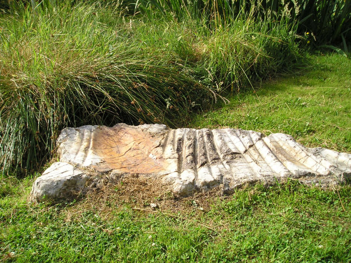
St-Benoit polissoir submitted by thecaptain on 14th Oct 2005. St Benoit polissoir, near St James.
Not a million miles from Mont St Michel, this lovely polissoir stone is nowadays nicely kept in a little garden type area beside the lane.
(View photo, vote or add a comment)
Log Text: Decide to take Dad here to see this special stone, so leave the autoroute at St James, to go have a look – the third time I will have tried to take Dad here, having missed it twice before due to roadworks and a shut bridge, and lateness on the previous occasions. Blimey, there are now big brown signs indicating it from the main road.
Set in its nice little marshy area, this is now very well looked after and presented, unlike the old description when I was first looking for it several years ago. The stone is a bit smaller than I remember it, but it is really wonderful. I just love being able to sit and stroke the very polished grooves, and let my mind wander back through the millennia. Again, Dad seemed well impressed at being able to see something like this.
Millières menhir
Trip No.210 Entry No.6 Date Added: 17th Aug 2026
Site Type: Standing Stone (Menhir)
Country: France (Normandie:Manche (50))
Visited: Yes on 5th Jun 2010. My rating: Condition 2 Ambience 2 Access 5
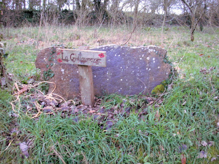
Millières menhir submitted by theCaptain on 30th Dec 2009. Almost certainly NOT the Millières menhir at La Guillaumerie.
(View photo, vote or add a comment)
Log Text: My second attempt to visit this stone was successful, although I spent a lot longer here than I needed to! I found the track near to Rougerie Sud farm, and parked near to a large stone in the hedge (talus) where there was room near to the junction with the road. I then walked all down the lane, looking in the fields and the hedges surrounding the fields, expecting to find the stone in the field to the south of the trackway. But I found nothing else, and decided that the stone I parked near to must be the menhir, so had a proper look. I decided that this was clearly once a menhir standing here, but it was good to have ruled out other possibilities. The stone is about 2.5 metres long, 1.2 metres wide and 0.7 m thick granite type stone. Probably once standing, and then surrounded by the hedge, this would have been a nice menhir. Although now fallen, it has now (probably fairly recently) been cleared from the talus all around it, looking like it is perhaps cared for by somebody – although not so well that it has had all sorts of stuff dumped beside it.
Menhir de Gouville
Trip No.210 Entry No.7 Date Added: 17th Aug 2026
Site Type: Standing Stone (Menhir)
Country: France (Normandie:Manche (50))
Visited: Yes on 5th Jun 2010. My rating: Condition 3 Ambience 3 Access 5
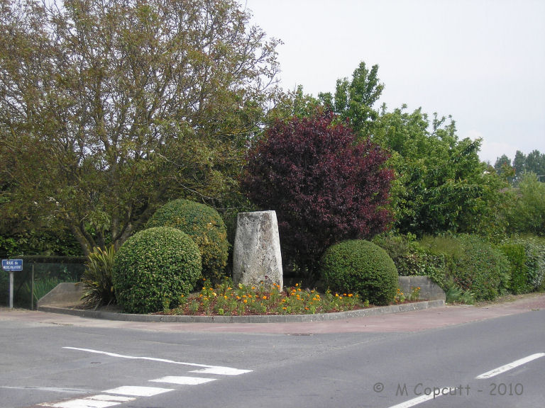
Menhir de Gouville submitted by TheCaptain on 20th Jun 2010. Just over 2 metres tall, this nicely shaped granite stone stands in a little tended garden area beside the Coutances road at the junction with Rue du Moulin-a-Vent.
(View photo, vote or add a comment)
Log Text: One of Gouville-sur-Mer's two little menhirs, this one stands within the village beside the Coutances road in a pleasant little garden like area. Just over 2 metres tall, this nicely shaped granite stone stands in a little tended garden area beside the Coutances road at the junction with Rue du Moulin-a-Vent. At some point, it’s top has been broken off. A couple of little old ladies were tending their garden opposite and seemed intrigued I was looking at the stone and taking pictures. They came over to talk to me, so I asked them what the stone was called, if it had a name. The reply was simply Le Menhir.
Roche a Trois Pieds
Trip No.210 Entry No.9 Date Added: 17th Aug 2026
Site Type: Burial Chamber or Dolmen
Country: France (Normandie:Manche (50))
Visited: Yes on 8th Jun 2010. My rating: Condition 3 Ambience 3 Access 4

Roche a Trois Pieds submitted by TheCaptain on 25th Jun 2010. The Roche a Trois Pieds is beside a natural outcropping of quartz rock in woodland at the top of the hill.
(View photo, vote or add a comment)
Log Text: I visited here this morning on the way to the ferry at Cherbourg, and was only really expecting to find some natural rocks, if anything, remaining nowadays. I am pleased to say that it all still exists, a natural outcropping of quartz rock in woodland at the top of the hill. The Roche a Trois Pieds is still there to be found, with a massive quartz block (~3m by 3m by 2m thick) perched on top of three smaller quartz blocks making a lovely arrangement, a few metres down from the top of the outcrop. I don’t think that the arrangement is entirely natural. It looks like the top stone has been moved down from the top outcrop a few yards away, not fallen and rolled, but moved sideways. But the thing that particularly made me think this is man made, was the arrangement of the smaller rocks underneath, which certainly didn't look like a natural chancelike arrangement. In fact it looked like two rows of side set slabs, about 4 each side in a parallel line, on top of which has been moved into place the massive capstone. I have seen many other dolmens/allée couvertes made in this way, where natural features have been enhanced, and I am ready to believe this is another of them.
Mont-Dol
Trip No.210 Entry No.10 Date Added: 18th Aug 2026
Site Type: Rock Outcrop
Country: France (Bretagne:Ille-et-Vilaine (35))
Visited: Yes on 7th Oct 2010. My rating: Condition 4 Ambience 5 Access 5
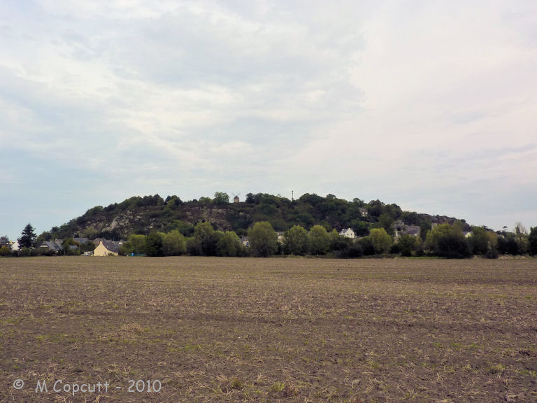
Mont-Dol submitted by TheCaptain on 23rd Oct 2010. Mont Dol is a large granite rock outcrop, dramatically jutting up through the flat coastal marshlands of the Baie de Mont St-Michel to the north of the ancient city of Dol-de-Bretagne, and in some ways is rather like Mont St-Michel itself, although nowadays completely enclosed within farmed lands.
(View photo, vote or add a comment)
Log Text: Mont Dol is a large granite rock outcrop, dramatically jutting up through the flat coastal marshlands of the Baie de Mont St-Michel to the north of the ancient city of Dol-de-Bretagne, and in some ways is rather like Mont St-Michel itself, although nowadays completely enclosed within farmed lands. There is evidence for this being a very special place since neolithic times, with evidence of settlement and ceremonial practices still to be found. Amongst the other things to visit on the plateau at the top of the rock is a little chapel and a tower topped by a large statue of the Virgin Mary, which may be climbed up to admire the splended 360° views. This mount has served as a holy place since Celtic times. During the Dark Ages Breton monks and religious society enjoyed a break here and stories say that saints Samson and Magloire spent time here. Legends abound, including that St Michael fought and beat the Devil here, and that signs of their battle have been left as curious marks which can be seen in certain rocks. I was rather taken by the place, it is a sort of downmarket Mont St Michel, and is not plagued by the mass tourism which spoils that wonderful place. It made me think immediately of Glastonbury Tor, with which there are many comparisons.
Pierre Longue de Saint-Jouan
Trip No.210 Entry No.11 Date Added: 18th Aug 2026
Site Type: Standing Stone (Menhir)
Country: France (Bretagne:Ille-et-Vilaine (35))
Visited: Yes on 7th Oct 2010. My rating: Condition 5 Ambience 4 Access 4
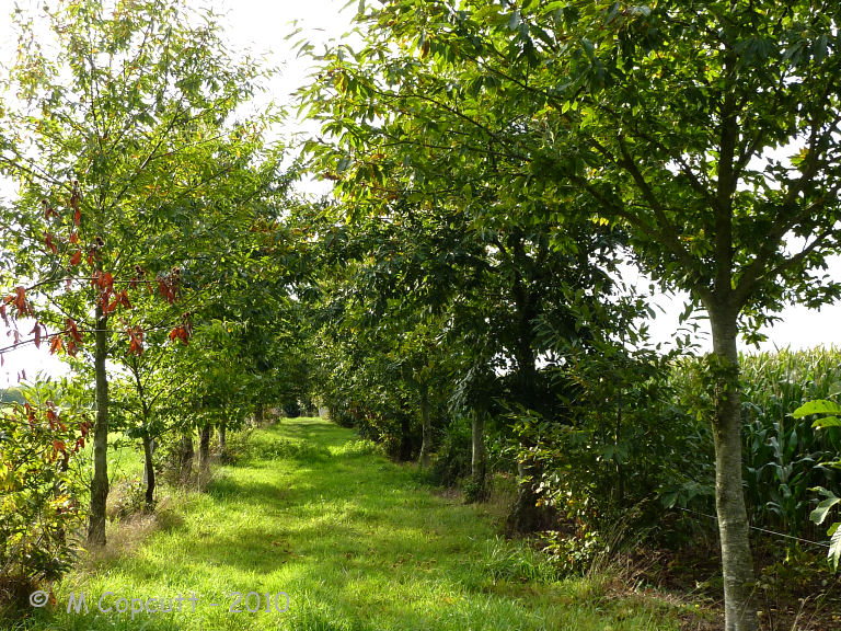
Pierre Longue de Saint-Jouan submitted by TheCaptain on 17th Oct 2010. Despite the menhir being so big, it still manages to play a game of hide and seek before finding it along chestnut lined trackways through fields of maize!
(View photo, vote or add a comment)
Log Text: A wonderful 6.5 metre tall and splendidly shaped granite menhir with a cross mounted on the top, which reminded me of a slightly shorter menhir de Champ Dolent. Despite the menhir being so big, it still manages to play a game of hide and seek before finding it along chestnut lined trackways through fields of maize! To find the menhir (which is well worth the effort) take the D795 south from the crossroads with the D796 Combourg to Bazouges road. About a kilometre south of the crossroads, and just south from crossing the little stream, take the small road to the east, which does have a sign to the menhir. Continue along this lane for about a kilometre, turning to the left a couple of times, until it ends at a farm, and park. From here walk along the farm track to the south, which had a very homemade sign in October 2010 between two fields of maize, for a few hundred metres until a crossing of ways. From here take the right turn west along a lovely chestnut tree lined avenue for a hundred or so metres and there the stone is. It is amazing how it hides so well behind the trees which are smaller than it !
Pierre Longue (Noyal-sous-Bazouges)
Trip No.210 Entry No.12 Date Added: 18th Aug 2026
Site Type: Standing Stone (Menhir)
Country: France (Bretagne:Ille-et-Vilaine (35))
Visited: Yes on 7th Oct 2010. My rating: Condition 4 Ambience 3 Access 5
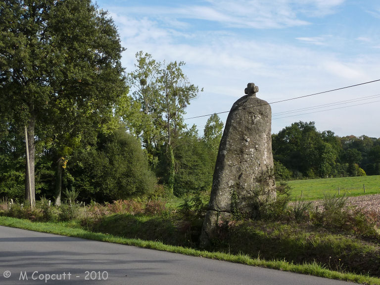
Pierre Longue (Noyal-sous-Bazouges) submitted by TheCaptain on 18th Oct 2010. This is a more than 5 metre tall menhir, which leans slightly towards the south, which stands beside the D796 roadside a kilometre or so to the west of Bazouges-la-Pérouse.
(View photo, vote or add a comment)
Log Text: A more than 5 metre tall menhir, which leans slightly towards the south, which stands in the ditch and bank beside the D796 roadside a kilometre or so to the west of Bazouges-la-Pérouse. The menhir is of a rounded off square section, about one and a half metres each side near the base. A cross has been mounted on the top.
Bois du Mont
Trip No.210 Entry No.16 Date Added: 18th Aug 2026
Site Type: Passage Grave
Country: France (Normandie:Manche (50))
Visited: Couldn't find on 9th Oct 2010

Bois du Mont submitted by TheCaptain on 16th Oct 2010. Remains of an Allée Couverte can be found in the private woodlands of Bois du Mont which is to the southwest of the village of Lithaire.
Info and picture from the site board at Bois de la Plesse.
(View photo, vote or add a comment)
Log Text: Remains of an Allée Couverte can be found in the private woodlands of Bois du Mont which is to the southwest of the village of Lithaire. This site was rediscovered and excavated in the mid 1960's. Information and a picture can be found on the site board at Bois de la Plesse.
Galerie des Forges
Trip No.210 Entry No.18 Date Added: 18th Aug 2026
Site Type: Passage Grave
Country: France (Normandie:Manche (50))
Visited: Couldn't find on 12th Oct 2010
Log Text: Having found more details of where to find this, it was time for another look, on a wonderful sunny morning while driving up to the ferry at Cherbourg. Much of the forest around here has recently been cleared and thinned, which I hoped would make finding any remains relatively easy. Despite much looking around in the meadows at the bottom of the hill, some of the forest at the lower hillside, and also along all the talus hedgerows at the sides of the trackways, I could find nothing.
Les Grises Pierres
Trip No.210 Entry No.19 Date Added: 18th Aug 2026
Site Type: Standing Stones
Country: France (Normandie:Manche (50))
Visited: Yes on 12th Oct 2010. My rating: Condition 2 Ambience 3 Access 3
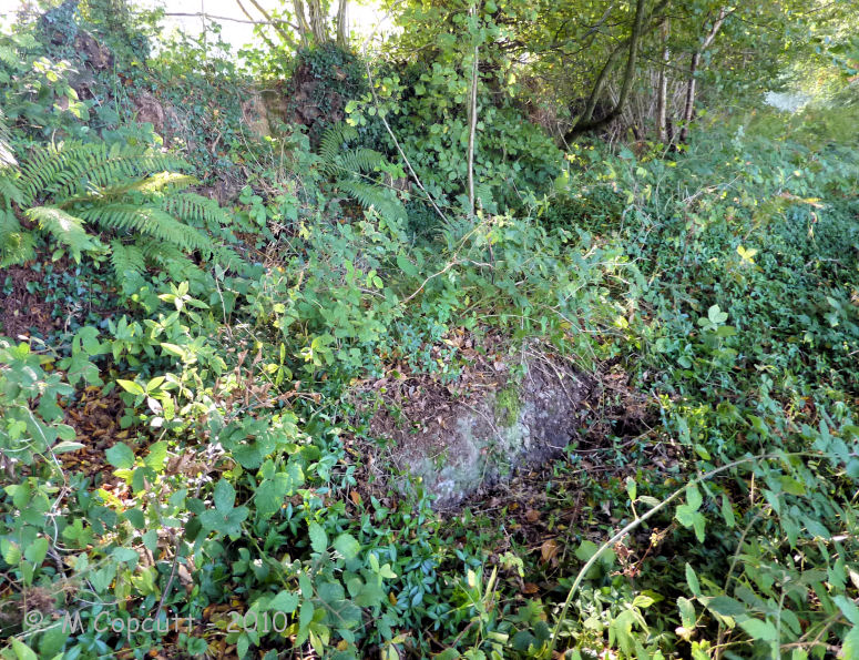
Les Grises Pierres submitted by TheCaptain on 15th Oct 2010. The second of Les Grises Pierres at Montaigu-la-Brisette.
This one is more well hidden and buried than its partner.
(View photo, vote or add a comment)
Log Text: On the slope of the conical Montaigu hill, behind the ancient hilltop church within its embanked circular churchyard, two neighbouring stones once stood, seperated by the old trackway "la chasse des fosses". I have found that these stones still exist, although now both fallen and becoming lost and buried underneath the growing vegetation and falling earth from the talus / embanked hedgerows at the edge of the ancient trackway. The first stone I found, relatively easily as it is close to the modern trackway, is the larger and most southerly of the two. It is about two metres long, up to 1.3 metres wide and of tapered section up to half a metre thick. It consists of a grey puddingstone conglomerate, mostly a smooth consistency one face, much more pebbley the other. It is recorded that it used to stand with its small end into the ground. Legends say that it turns three times on Christmas Eve. The second stone was much harder to find, as it was almost completely buried, and is about 25 metres northeast from its companion along the trackway under the growth of the uphill side talus / hedgerow. It is slightly smaller than its mate, and again consists of a grey puddingstone conglomerate. The stones can be found by following an ancient trackway downhill towards the northwest from the hilltop churchyard for a few hundred metres, and then taking the trackway which encircles the hill to the north. This is "La Chasse des Fosses", despite the modern name on maps etc. A hundred metres or so along this trackway the stones can be found in the undergrowth on the uphill side. The modern track is a new version of the old trackway made for modern times, and is outside the ancient hollow trackway on the downhill side. The ancient track can still be followed between the hedges besides this, and indeed does run between the stones. There are several other smaller bits of puddingstone to be found beside the various trackways, and indeed several pieces strategically placed within the churchyard at the top of the hill. On the top of the conical shaped hill here, is the old church and various other chapel constructions which are sited within the oval/circular churchyard. The churchyard is entirely enclosed within an embanked oval, consisting of a banked and perhaps ditched construction, with many large stones to be found within the banks. These embankments have growing within them many ancient yew trees. I have to say that this is a tremendous place. The ancient church and chapels sited atop the hill enclosed in their circular enclosure with ancient yew tree ridden borders atop the banks and ditches give it a wonderful atmosphere. And with some very obviously ancient holloways and tracks around the hillside, the whole place just reeks of history. This place truly has a magic about it.