Contributory members are able to log private notes and comments about each site
Sites TheCaptain has logged. View this log as a table or view the most recent logs from everyone
Westmoorgate cairn
Date Added: 8th Oct 2012
Site Type: Cairn
Country: England (Cornwall)
Visited: Yes on 22nd Sep 2012

Westmoorgate cairn submitted by theCaptain on 8th Oct 2012. The gps track of my walking to the north of Westmoorgate stone circle, firstly to the cairn (WP17) and then around some significant stones, which have indeed made a rather nice circle.
Plotted onto Google Earth.
(View photo, vote or add a comment)
Log Text: None
Westmoorgate circle
Date Added: 8th Oct 2012
Site Type: Stone Circle
Country: England (Cornwall)
Visited: Yes on 22nd Sep 2012
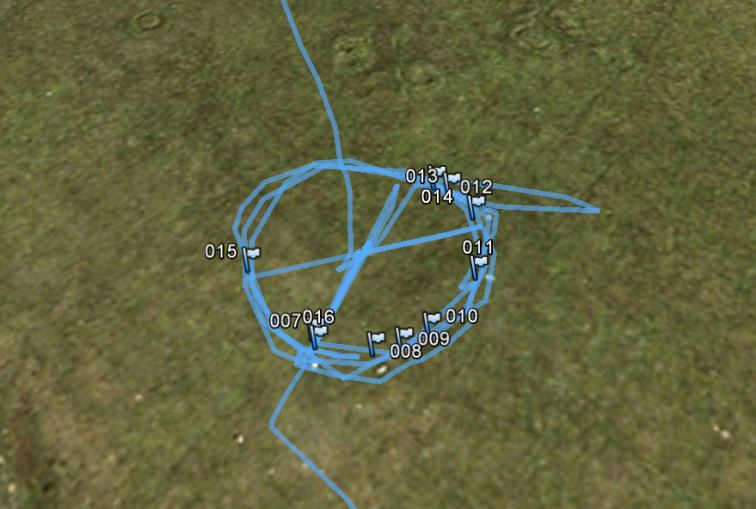
Westmoorgate circle submitted by theCaptain on 6th Oct 2012. I walked around the circle and made a waypoint on my gps for each of the stones.
I have plotted these onto Google Earth
(View photo, vote or add a comment)
Log Text: None
Hadleigh Roundhouse
Date Added: 29th Oct 2019
Site Type: Ancient Village or Settlement
Country: England (Essex)
Visited: Yes on 27th Aug 2012
Hadleigh Roundhouse submitted by theCaptain on 27th Aug 2012. Hadleigh Country Park in Essex, has built a replica Iron Age roundhouse to
provide a sheltered working environment forschool groups.
(View photo, vote or add a comment)
Log Text: None
Macellum of Pompeii
Date Added: 29th Oct 2019
Site Type: Modern Stone Circle etc
Country: Italy (Marche)
Visited: Yes on 15th Jun 2012
Macellum of Pompeii submitted by theCaptain on 15th Jun 2012. A circle of 12 volcanic tuff stones erected in the central Macellum of the ancient city of Pompeii.
(View photo, vote or add a comment)
Log Text: None
Menhir de Soulangy
Date Added: 29th Oct 2019
Site Type: Standing Stone (Menhir)
Country: France (Normandie:Calvados (14))
Visited: Yes on 15th May 2012
Menhir de Soulangy submitted by theCaptain on 15th May 2012. Menhir discovered during the construction of the RN 158 near to Soulangy. It has now been re-erected in the parking area of the Soulangy rest area, on the western (southbound) side.
(View photo, vote or add a comment)
Log Text: None
Chew Stoke
Date Added: 29th Oct 2019
Site Type: Stone Circle
Country: England (Somerset)
Visited: Yes on 12th May 2012

Chew Stoke submitted by theCaptain on 12th May 2012. Destroyed stone circle once supposed to have stood near where the Methodist church is now built. Some stones were to be found laying in the hedge nearby in the last century.
(View photo, vote or add a comment)
Log Text: None
Leigh Down
Date Added: 29th Oct 2019
Site Type: Stone Circle
Country: England (Somerset)
Visited: Yes on 12th May 2012
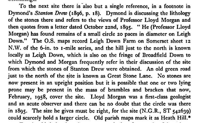
Leigh Down submitted by theCaptain on 12th May 2012. Description of Leigh Down stone circle from "The Lost Stone Circles of North Somerset" by EK Tratman.
(View photo, vote or add a comment)
Log Text: None
Langrais menhirs
Trip No.212 Entry No.6 Date Added: 26th Mar 2020
Site Type: Standing Stones
Country: France (Normandie:Calvados (14))
Visited: Yes on 7th May 2012. My rating: Condition 4 Ambience 3 Access 4
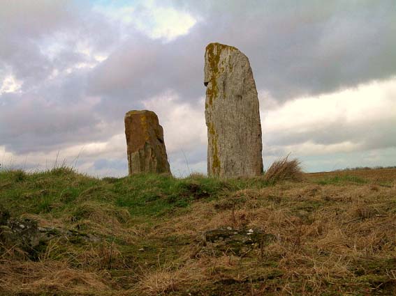
Langrais menhirs submitted by Rida on 27th Feb 2011. Site in Normandie:Calvados (14) France
(View photo, vote or add a comment)
Log Text: Having had a good look at the IGN 1:25000 map, I saw that there is a trackway running east from the road south of Mont Joly, which runs from the bottom of the hill diagonally up to the approximate position of the stones. Even better, when arriving there for a look, the trackway was open and easily driveable, and so I took this option on this showery afternoon, and when emerging from below the wood at the top of the hill, there was plenty of space to park amongst a large composting area! Left Dad in the car while I went out into the wind and drizzle to find the stones, and there they were, just round the back of the big pile of manure!
The two stones stand at the edge of an open rocky outcrop at the top of the hill, covered in wildflowers at this time of year, but I learned that the stones are not in their original positions, having been moved there by the farmer at some point in the past. The two stones are very different, the larger stone being a whitish quartz type stone, between 3.5 nd 4 metres tall, while its shorter neighbour is a reddish colour, and only about 1.6 metres tall. There are plently of other large lumps of stone laying about here, which may have been broken from the two menhirs, or just other examples of field clearance.
On the way down from the stones, through a gateway into the wood I could see another rocky outcrop with various large stones standing around, a couple of them probably at least 2 metres tall. This was all now made into a nice garden feature, but is there any ancient significance to the stones? Back onto the road, and I noticed it was called Route des Menhirs, and up towards the top of the hill there was another garden with some large rocks standing in it.
Onto the top of Mont Joly, and it is clear that there are large rocks all over the place, and it is easy to imagine that thee was once an alignement of large stones running along the top of the hill into the ancient settlement. Walking along the edge of the field, and then the pathway to the end of the promontary, and large stones can be seen laying around everywhere, many clearly not just a local outcropping of rock, but various shapes, sizes and types of stone. Many of these rocks were now incorporated into garden features, but many more are just laying there, slowly getting buried by the undergrowth. It really is a fascinating area, and I do wonder what a proper survey of this ancient hilltop would turn up.
Mont Joly
Trip No.212 Entry No.8 Date Added: 26th Mar 2020
Site Type: Ancient Village or Settlement
Country: France (Normandie:Calvados (14))
Visited: Yes on 7th May 2012. My rating: Condition 2 Ambience 4 Access 5
Mont Joly submitted by theCaptain on 15th Jan 2014. This promontory site is surrounded on three sides by the steep gorge of the river Laizon, and the eastern end has been defended by ramparts, a little of which can now be seen between the church and water tower.
In this picture a raise in the land can be seen to the left of my Dad.
(View photo, vote or add a comment)
Log Text: What an intriguing place this is, and deserving of much more thorough exploration.
Menhir Couché Lieu Gobin
Date Added: 29th Oct 2019
Site Type: Standing Stone (Menhir)
Country: France (Normandie:Calvados (14))
Visited: Yes on 4th May 2012

Menhir Couché Lieu Gobin submitted by TheCaptain on 4th May 2012. at the corner of the wet and rough trackway, the stone can be seen in the field by the fence.
(View photo, vote or add a comment)
Log Text: None
Stanton Drew - Avenue
Date Added: 29th Oct 2019
Site Type: Multiple Stone Rows / Avenue
Country: England (Somerset)
Visited: Yes on 29th Apr 2012

Stanton Drew - Avenue submitted by theCaptain on 29th Apr 2012. Sem tried to connect with the repulsive stone at the end of the avenue, but either his batteries were flat, or being from Wales his connections were of the wrong kind.
Whatever, he was not thrown into the next field.
(View photo, vote or add a comment)
Log Text: None
Stanton Drew SSW
Date Added: 29th Oct 2019
Site Type: Stone Circle
Country: England (Somerset)
Visited: Yes on 29th Apr 2012

Stanton Drew SSW submitted by theCaptain on 29th Apr 2012. Terence Meaden telling us of the only excavations done here in living memory - by a badger.
(View photo, vote or add a comment)
Log Text: None
Felton Common Suck Stone
Date Added: 29th Oct 2019
Site Type: Natural Stone / Erratic / Other Natural Feature
Country: England (Somerset)
Visited: Yes on 29th Apr 2012
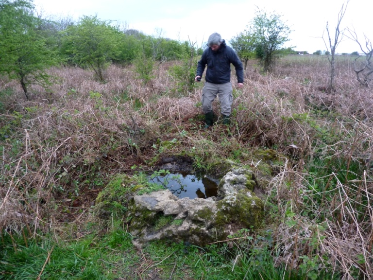
Felton Common Suck Stone submitted by theCaptain on 29th Apr 2012. Hamish F giving the remaining overgrowth a seeing to, after finding what we thought was probably the Suck Stone
(View photo, vote or add a comment)
Log Text: None
Stanton Drew Great Circle
Date Added: 29th Oct 2019
Site Type: Stone Circle
Country: England (Somerset)
Visited: Yes on 29th Apr 2012
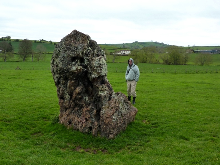
Stanton Drew Great Circle submitted by theCaptain on 29th Apr 2012. Uh Oh, what is that popped out from behind the stones when you are not looking? Some sort of troll from Malreward? or just a hoody wearing chav from the other side of Maes Knoll?
(View photo, vote or add a comment)
Log Text: None
Peyre Levade (La Borie Rouge)
Trip No.203 Entry No.213 Date Added: 21st Apr 2020
Site Type: Burial Chamber or Dolmen
Country: France (Midi:Lot (46))
Visited: Yes on 17th Jan 2012. My rating: Condition 2 Ambience 2 Access 4
Peyre Levade (La Borie Rouge) submitted by theCaptain on 17th Jan 2012. Remains of a small dolmen in a garden just to the north of Lalbenque.
(View photo, vote or add a comment)
Log Text: Remains of a small dolmen in a garden just to the north of Lalbenque. It is not well cared for and has had a large hedge planted between it and the roadside to presumably stop people like me having a look. In fact it looks as if one of the side slabs has recently been split.
Giverzac Dolmen
Trip No.203 Entry No.215 Date Added: 21st Apr 2020
Site Type: Burial Chamber or Dolmen
Country: France (Aquitaine:Dordogne (24))
Visited: Yes on 16th Jan 2012. My rating: Condition 2 Ambience 3 Access 5
Giverzac dolmen submitted by theCaptain on 16th Jan 2012. Remains of a little dolmen now outside the gates to the Banque de France’ Giversac Enterprise Centre, where it is used for sheltering a couple of floodlights.
(View photo, vote or add a comment)
Log Text: Remains of a little dolmen now outside the gates to the Banque de France’ Giversac Enterprise Centre and it shelters a couple of floodlights. The capstone is about 2.5 by 2 metres broken at one end and it sits on a few various support stones. I suspect it’s been jumbled about a bit.
Finding this involved some extremely steep and narrow lanes up the vertiginous sides of the Dordogne river from Vitrac and getting away again after was just as bad as the roads through Domme are banned to campervans due to the small narrow cliff face hanging roads so although you can park next to the dolmen an access rating of 5 is perhaps a bit high ! There are no signs.
Les Grosses Devises (W)
Date Added: 29th Oct 2019
Site Type: Standing Stones
Country: France (Normandie:Calvados (14))
Visited: Yes on 15th Jan 2012
Les Grosses Devises (W) submitted by theCaptain on 15th Jan 2012. The western of the two main Les Grosses Devises stones still standing, seen here on a sunny winter morning looking north from the farmtrack which leads up from the west at Barbieres.
(View photo, vote or add a comment)
Log Text: None
Les Grosses Devises (E)
Date Added: 29th Oct 2019
Site Type: Standing Stone (Menhir)
Country: France (Normandie:Calvados (14))
Visited: Yes on 15th Jan 2012
Les Grosses Devises (E) submitted by theCaptain on 15th Jan 2012. The eastern of the two main Les Grosses Devises stones still standing, seen here on a sunny winter morning looking northeast from the farmtrack which leads up from the west at Barbieres.
(View photo, vote or add a comment)
Log Text: None
Menhir des Planches
Date Added: 29th Oct 2019
Site Type: Standing Stone (Menhir)
Country: France (Normandie:Calvados (14))
Visited: Yes on 29th Dec 2011
Menhir des Planches submitted by theCaptain on 29th Dec 2011. The stone can be seen clearly against the skyline, although it is not on the top of the hill.
(View photo, vote or add a comment)
Log Text: None
Pierre du Hu
Date Added: 29th Oct 2019
Site Type: Standing Stone (Menhir)
Country: France (Normandie:Calvados (14))
Visited: Yes on 15th Nov 2011
Pierre du Hu submitted by theCaptain on 15th Nov 2011. At the northeastern corner of the field of the Montchauvin Alignements, the largest, The Pierre du Hu, stands just under three metres tall.
(View photo, vote or add a comment)
Log Text: None
