Contributory members are able to log private notes and comments about each site
Sites TheCaptain has logged. View this log as a table or view the most recent logs from everyone
Peyro-Hitto
Date Added: 26th Oct 2020
Site Type: Standing Stone (Menhir)
Country: France (Midi:Haute-Garonne (31))
Visited: Couldn't find on 9th Sep 2005
Log Text: Drive north up the Garonne to St Gaudens. Its still not too late so I head on, and decide to head for St Girons. I miss a turn and end up in St Martory, I think there's a stone here. Having spent ages trying to park, I wasn't thinking straight because it was getting late and I had a fairly long way to travel.
No mention of it on the village maps, and I didn’t read my notes first, and thought it to be near the bridge, but found nothing. I didn’t think of looking at the obvious place by church, where it supposedly is.
It is a nice old bridge though.
Peyro Dreta
Trip No.205 Entry No.90 Date Added: 28th Oct 2020
Site Type: Standing Stone (Menhir)
Country: France (Languedoc:Pyrénées-Orientales 66)
Visited: Yes on 12th Sep 2005. My rating: Condition 2 Ambience 3 Access 4
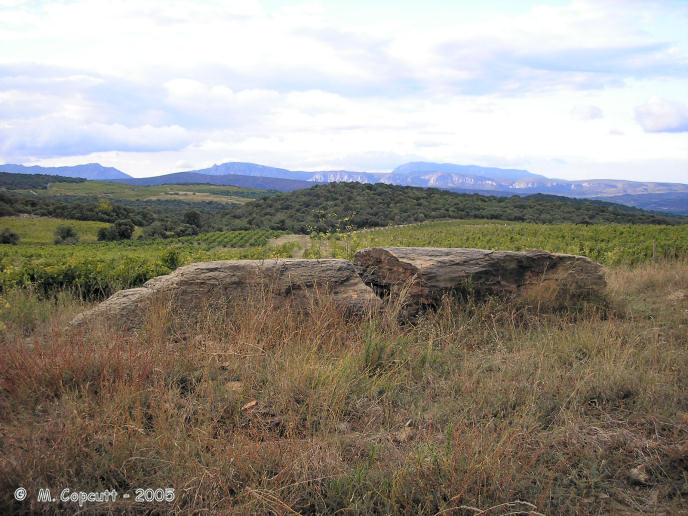
Peyro Dreta submitted by thecaptain on 3rd Mar 2006. This fallen and broken menhir, once more than 4 metres tall, has beautiful views over the Fenouillades valley to the north, with Queribus castle and Tautavel clearly visible.
(View photo, vote or add a comment)
Log Text: This fallen and broken menhir, once more than 4 metres tall, has beautiful views over the Fenouillades valley to the north, with Queribus castle and Tautavel clearly visible. The menhir can be found about a kilometres walk down a dirt track amongst the vines, about 0.7 kilometres to the west of the Col de Bataille. The start of the track is easy to find, as it is marked with a large menhir like stone at the junction beside the vineyards. Perhaps this stone itself was once a proper menhir, which has now been re-erected.
Peyro Clabado
Trip No.200 Entry No.80 Date Added: 18th Jun 2020
Site Type: Rock Outcrop
Country: France (Midi:Tarn (81))
Visited: Yes on 24th Sep 2000. My rating: Condition 4 Ambience 4 Access 4
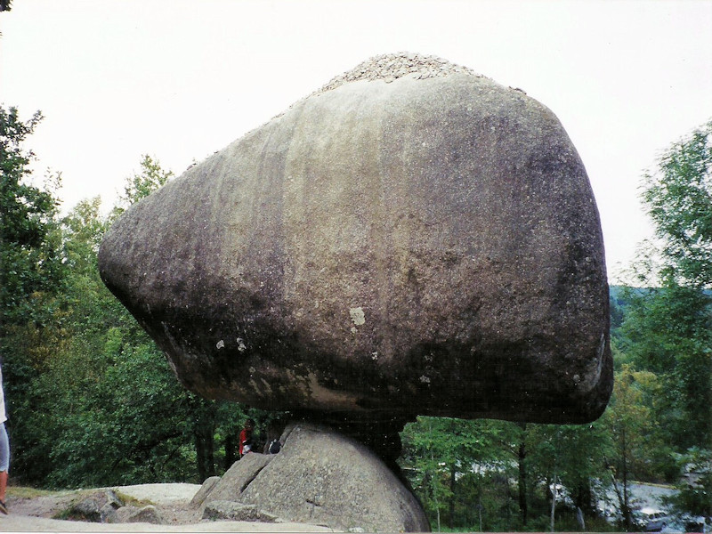
Peyro Clabado submitted by TheCaptain on 9th Apr 2016. Le Peyro Clabado, an extremely large (780 tonnes) and celebrated balanced rock to the east of Castres.
(View photo, vote or add a comment)
Log Text: Extremely large (780 tonnes) and celebrated balanced rock, in an area abounding with many odd rock shapes to the east of Castres. Some of these have been revered since history began.
Peyrefitte
Trip No.203 Entry No.233 Date Added: 22nd Apr 2020
Site Type: Standing Stone (Menhir)
Country: France (Aquitaine:Gironde (33))
Visited: Yes on 3rd Jun 2005. My rating: Condition 5 Ambience 3 Access 5
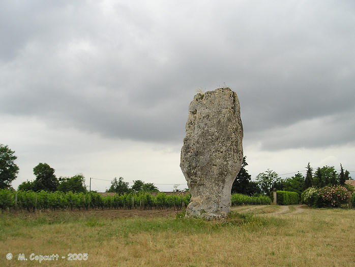
Peyrefitte submitted by thecaptain on 15th Jan 2006. Large menhir near to the Dordogne river in the commune of St-Sulpice-de-Faleyrens in Gironde. Signposted from all around, and with a little parking area, this huge and nicely shaped menhir stands in a little field amongst the vines.
(View photo, vote or add a comment)
Log Text: Signposted from all around, and with a little parking area, this huge and nicely shaped menhir stands in a little field amongst the vines. This is the largest standing stone in southwest France, and it is 5.2 metres tall, 3 metres wide and less than a metre thick, with the bottom part of it chipped away to make the distinctive shape. There is a little hollow in the bottom of it, apparently made for offerings to be placed in during the middle ages.
Estimated to weigh 50 tonnes, the stone has been brought to this position from at least 2.5 kilometres away. It has been dated to 2500 BC, contemporary with the various allée-couvertes to be found in the region.
It is said by legend to mark an entry to the subterranean world, can cure rheumatism, and is good for curing a limp. But while I am here, a massive thunderstorm has arrived, and I must rush back to the van quickly.
Peyrebrune megalith
Trip No.203 Entry No.92 Date Added: 6th Apr 2020
Site Type: Standing Stone (Menhir)
Country: France (Aquitaine:Dordogne (24))
Visited: Couldn't find on 20th May 2005
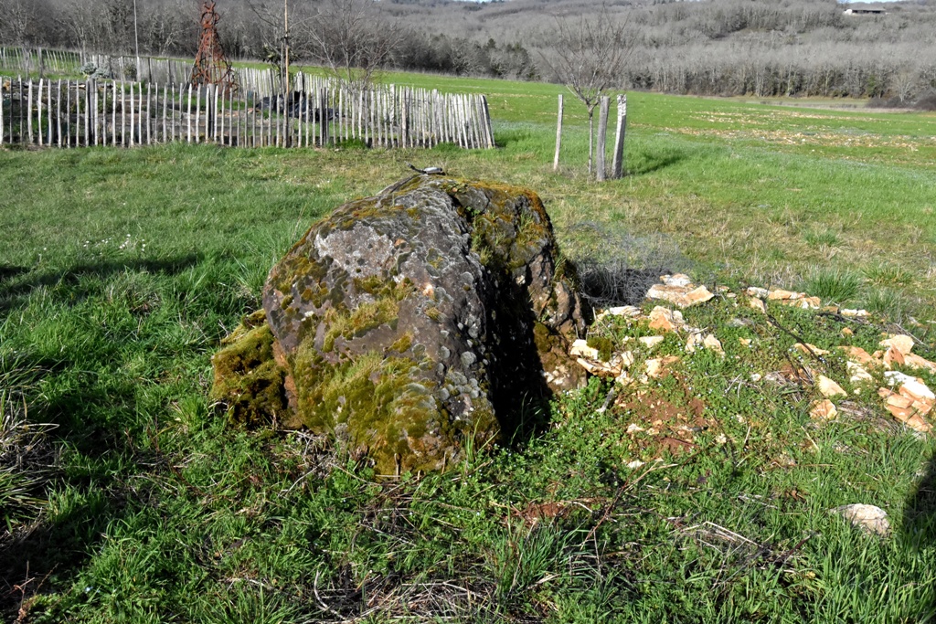
Peyrebrune megalith submitted by LaDragonne on 2nd Mar 2024. La Peyre Brune à côté de gravats, sur un site dominant le paysage, Sainte-Orse, Site in Aquitaine: Dordogne (24) France
(View photo, vote or add a comment)
Log Text: Near the hamlet of Rozas to the east of Saint-Orse is the farm called Peyre Brune where there are some megalithic remains. I understand it is a large menhir but with stories surrounding it that it is a meteorite which has crashed to earth. On the tiny roads in this area I could find nowhere to park or indeed turn round so gave up perhaps a bit too easily.
Peyrebrune (Seyssac)
Trip No.203 Entry No.64 Date Added: 5th Apr 2020
Site Type: Burial Chamber or Dolmen
Country: France (Aquitaine:Dordogne (24))
Visited: Yes on 17th May 2005. My rating: Condition 3 Ambience 4 Access 3
Peyrebrune (Seyssac) submitted by theCaptain on 17th May 2012. A kilometre or so down a rough track called Chasse de Pierre Brune from the D109 near Segonzac can be found the remains of this rectangular chambered dolmen.
(View photo, vote or add a comment)
Log Text: A kilometre or so down a rough track called Chasse de Pierre Brune from the D109 near Segonzac can be found the remains of this rectangular chambered dolmen. The chamber has dimensions of about 3 m by 2 m and made with well positioned stone blocks. There is a capstone which only covers the western end.
It’s a pity about the chestnut trees growing in it.
Peyre-Crabère
Trip No.205 Entry No.53 Date Added: 25th Oct 2020
Site Type: Standing Stone (Menhir)
Country: France (Midi:Hautes-Pyrénées (65))
Visited: Yes on 6th Sep 2005. My rating: Condition 3 Ambience 2 Access 5
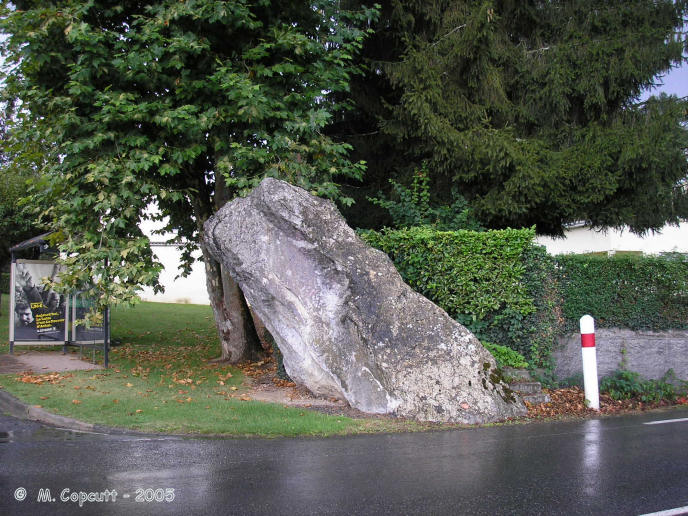
Peyre-Crabère submitted by thecaptain on 22nd Jan 2006. Right beside the D.940 road as it enters the northern boundary of the town of Lourdes from Pau direction, can be found this large leaning menhir.
It sits right at the corner of a little housing road, Rue Peyre-Crabère, and has a bus shelter and garden hedge for company on its other two sides.
(View photo, vote or add a comment)
Log Text: Right beside the D.940 road as it enters the northern boundary of the town of Lourdes from Pau direction, can be found this large leaning menhir. It sits right at the corner of a little housing road, Rue Peyre-Crabère, and has a bus shelter and garden hedge for company on its other two sides. The stone is about 3 metres tall, and leans almost 30° from vertical. While I was stopped here, it was thundering, pouring with rain, and very busy with traffic.
Peyre Levade (La Borie Rouge)
Trip No.203 Entry No.213 Date Added: 21st Apr 2020
Site Type: Burial Chamber or Dolmen
Country: France (Midi:Lot (46))
Visited: Yes on 17th Jan 2012. My rating: Condition 2 Ambience 2 Access 4
Peyre Levade (La Borie Rouge) submitted by theCaptain on 17th Jan 2012. Remains of a small dolmen in a garden just to the north of Lalbenque.
(View photo, vote or add a comment)
Log Text: Remains of a small dolmen in a garden just to the north of Lalbenque. It is not well cared for and has had a large hedge planted between it and the roadside to presumably stop people like me having a look. In fact it looks as if one of the side slabs has recently been split.
Peyre Levade (Condat)
Trip No.203 Entry No.60 Date Added: 5th Apr 2020
Site Type: Burial Chamber or Dolmen
Country: France (Aquitaine:Dordogne (24))
Visited: Couldn't find on 17th May 2005
Peyre Levade (Condat) submitted by alchemille on 3rd Aug 2013. Dolmen Peyre levade de Fouret, Condat sur Trincou, Dordogne.
(View photo, vote or add a comment)
Log Text: A couple of kilometres east of Brantôme is marked a dolmen on my ign map but despite trying hard to find it I saw no signs of anything and there was nowhere at all to park on very small country lanes to get out and have a proper look.
Peyre Lebade
Trip No.203 Entry No.220 Date Added: 21st Apr 2020
Site Type: Standing Stone (Menhir)
Country: France (Aquitaine:Gironde (33))
Visited: Yes on 2nd Jun 2005. My rating: Condition 2 Ambience 2 Access 5
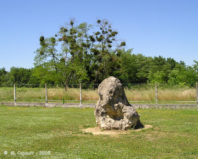
Peyre Lebade submitted by thecaptain on 9th Jan 2006. Peyre Lebade near the village of Salles-de-Castillon in Gironde.
In the corner of the road junction to the west of the village centre can be seen a small standing stone fenced in to a little grassy garden area.
(View photo, vote or add a comment)
Log Text: While looking at the village map by the Mairie to see if it marked any of the supposedly local ancient stones I noted an area called Peyre Lebade so of course I went to have a look. In the corner of the road junction here to the west of the village centre can be seen a small standing stone fenced in to a little grassy garden area. It cant be much more than a metre tall and is well weathered so I assume it’s a proper menhir.
Peyre Hicade de Payolle
Trip No.205 Entry No.61 Date Added: 25th Oct 2020
Site Type: Standing Stone (Menhir)
Country: France (Midi:Hautes-Pyrénées (65))
Visited: Yes on 8th Sep 2005. My rating: Condition 3 Ambience 5 Access 4
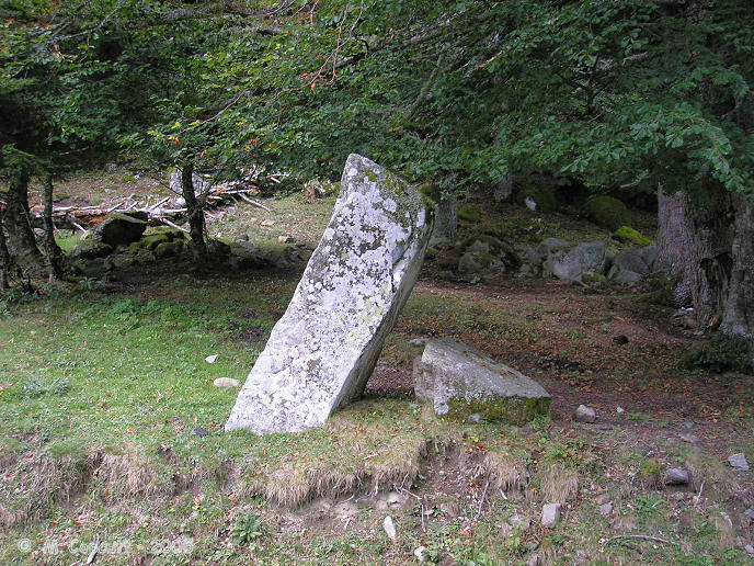
Peyre Hicade de Payolle submitted by thecaptain on 22nd Jan 2006. After a very long time of looking, to start with I wasnt totally sure that I found the real stone, but the one I found at least looks like a proper menhir, and not a natural fallen rock.
It is still over 2 metres high although the top has broken off and lies at its foot.
(View photo, vote or add a comment)
Log Text: I spent hours looking for this, largely because walking around here in such a beautiful part of the world and the wonderful scenery is such a great pleasure. The stone is somewhere to the south of the Lac de Payolle, and its holiday complex. There is even a 2 hour circular walk signposted and named Peyre Hicade. But to properly find the stone takes a lot of doing, and it is not actually passed by the named walking trail !
To start with I wasn't totally sure that I found the real stone, but the one I found at least looks like a proper menhir, and not a natural fallen rock. It is just over 2 metres high although the top has broken off and lies at its foot, and by a trackway above the road at the furthest point from the lake on the Peyre Hicade walk, although the signposts for the path do not lead or point to the stone.
If following the road south from the lake, just after the road crosses a bridge, and then does an almost hairpin turn to the right, park and follow a trackway up the hill to the left, on the uphill side of the stream. If this is not the menhir, I do not know what is - it looks like an other picture I have seen.
Peyre Gagès Dolmen
Trip No.203 Entry No.206 Date Added: 21st Apr 2020
Site Type: Burial Chamber or Dolmen
Country: France (Midi:Lot (46))
Visited: Yes on 31st May 2005. My rating: Condition 3 Ambience 3 Access 4
Peyre Gagès dolmen submitted by theCaptain on 2nd Mar 2015. Peyre Gagès dolmen can be seen just about 20 metres to the east of the D143 road a few kilometres to the north of Limogne. It stands in a field with traces of its mound still around it and can clearly be seen from the road.
(View photo, vote or add a comment)
Log Text: This dolmen can be seen just about 20 metres to the east of the D143 road a few kilometres to the north of Limogne. It stands in a field with traces of its mound still around it and can clearly be seen from the road. The field had a herd of cows in it at the time of my visit and was well fenced so I didn’t go to inspect it at close hand. It looks to be a bit smaller than the average dolmen in these parts.
Peyre d'Ermale
Trip No.203 Entry No.58 Date Added: 5th Apr 2020
Site Type: Burial Chamber or Dolmen
Country: France (Aquitaine:Dordogne (24))
Visited: Yes on 17th May 2005. My rating: Ambience 4 Access 3
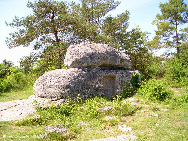
Peyre d'Ermale submitted by thecaptain on 7th Dec 2005. Peyre d'Ermale.
I eventually found, after about a kilometre walk, a strange lump of natural rock which has been shaped and has a squarish cut out in one side.
(View photo, vote or add a comment)
Log Text: Marked on my ign map as a menhir but signposted along a track from the road as Dolmen I parked and walked to see what I could find.
What I eventually found after about a kilometre walk was a strange lump of natural rock which has been shaped has a squarish cut out in one side and a round basin to the south with little channels cut in the surrounding rocks to presumably collect water.
I have no idea what this is meant to be and indeed no idea whether this is the proper megalithic remains! Later I find out that this is indeed the remains of a megalithic burial chamber (dolmen a bit incorrect perhaps). And thet there is also a menhir nearby. I wonder where that was then.
Peyrasse menhir
Trip No.205 Entry No.55 Date Added: 25th Oct 2020
Site Type: Standing Stone (Menhir)
Country: France (Midi:Hautes-Pyrénées (65))
Visited: Couldn't find on 6th Sep 2005
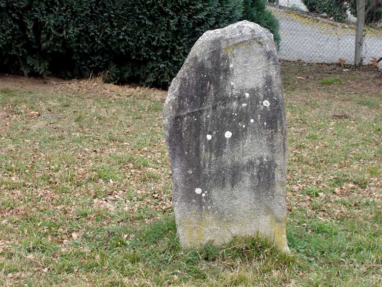
Peyrasse menhir submitted by Nick- on 3rd Jan 2008. Menhir de Peyrasse, 2nd Jan 2007.
Same view looking Westwards, camera poked through the fence. There was a sleeping guard dog on the other side......
(View photo, vote or add a comment)
Log Text: I had a bit of a look for this, but it is not on the map in detail, and I found nothing obvious in the real world.
Peyralade Dolmen
Trip No.200 Entry No.3 Date Added: 17th Jun 2020
Site Type: Burial Chamber or Dolmen
Country: France (Midi:Tarn (81))
Visited: Yes on 19th Mar 2000. My rating: Condition 4 Ambience 3 Access 5
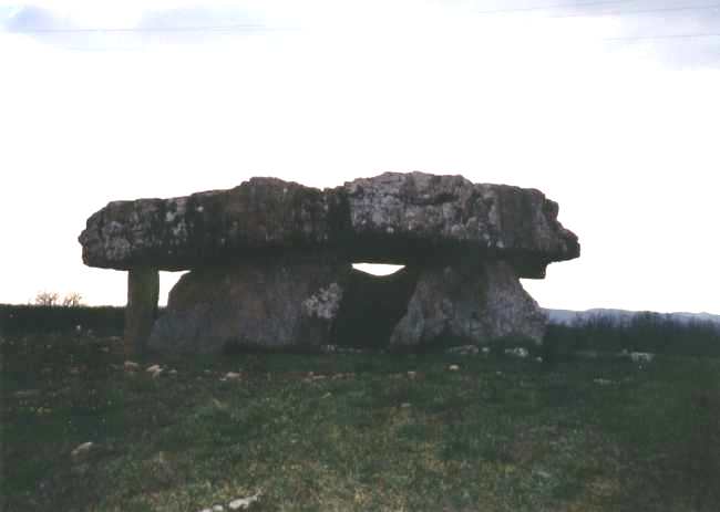
Peyralade Dolmen submitted by thecaptain on 6th Dec 2003. The Dolmen de Peyralade, near to the village of Vaur, Tarn Southwest France.
This dolmen is on the top of the plateau which the Aveyron river cuts through in a splendid gorge.
(View photo, vote or add a comment)
Log Text: A day driving NE from Toulouse. L’Isle-sur-Tarn, Gaillac, Cordes-sur-Ciel, Vaour, 2 Dolmens, Castelnau-de-Montmiral. The Dolmen de Peyralade, is near to the village of Vaur, Tarn Southwest France. This dolmen is on the top of the plateau which the Aveyron river cuts through in a splendid gorge.
Peyralade Dolmen
Trip No.205 Entry No.38 Date Added: 17th Jun 2020
Site Type: Burial Chamber or Dolmen
Country: France (Midi:Tarn (81))
Visited: Yes on 2nd Sep 2005. My rating: Condition 4 Ambience 3 Access 5
Peyralade Dolmen submitted by theCaptain on 9th Dec 2010. The large but broken capstone sits high above the ground on top of its two side supports (and 4 additional modern support stones).
(View photo, vote or add a comment)
Log Text: This dolmen is easily found, as it stands on a traffic island at the junction of the D.5 and D.91 roads a couple of kilometres to the north of the village of Vaour, on the high plateau to the south of the river Aveyron, and is signposted from several kilometres away.
The large but broken 5 metres by 3 metres capstone sits high above the ground on top of its two side supports (and 4 additional modern support stones) covering a chamber 4 m by 2 m oriented towards the southeast at 135°. Traces of the mound which once covered this dolmen are still visible although now well spread out.
Although this dolmen has lots to recommend it, in its size and high position with splendid views, it unfortunately sits at a fairly busy road junction, and the modern support stones are perhaps a little too obvious.
Pey de Fontaine
Trip No.203 Entry No.268 Date Added: 24th Apr 2020
Site Type: Chambered Cairn
Country: France (Pays de la Loire:Vendée (85))
Visited: Yes on 6th Jun 2005. My rating: Condition 2 Ambience 3 Access 4
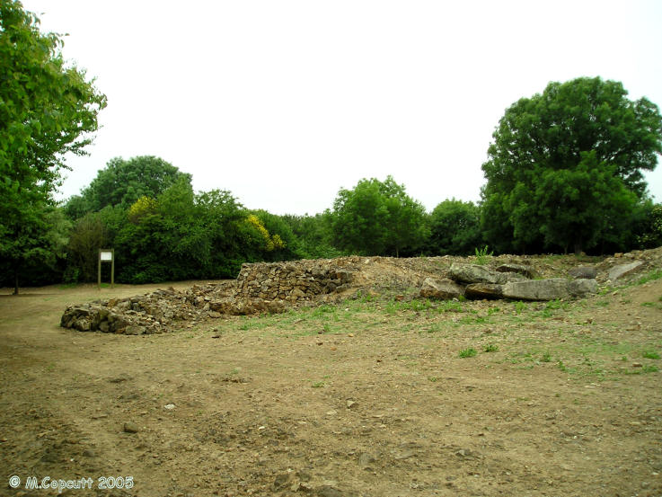
Pey de Fontaine submitted by thecaptain on 15th Dec 2005. The largest prehistoric monument in the departement of Vendée, this is a large stone cairn which contains two dolmen chambers with entry passageways.
The two chambers each have entry corridors of 20 metres length, opening out to the southeast.
However, the monument is not much to look at at present, as it is undergoing excavations prior to restoration, and it looks a bit like an empty building site.
(View photo, vote or add a comment)
Log Text: The largest prehistoric monument in the departement of Vendée, this is a large stone cairn which contains two dolmens with entry passageways. Estimated to be 6000 years old, the cairn is rectangular, about 35 metres by 30 metres and is built with several drystone wall steps. The two chambers each have entry corridors of 20 metres length, opening out to the southeast.
However, the monument is not much to look at at present, as it is undergoing excavations prior to restoration, and it looks a bit like an empty building site. it is found at the end of a long farm lane, and there was nowhere to turn my campervan around near the monument.
Petites Jaunières
Trip No.203 Entry No.255 Date Added: 23rd Apr 2020
Site Type: Standing Stone (Menhir)
Country: France (Pays de la Loire:Vendée (85))
Visited: Yes on 5th Jun 2005. My rating: Condition 3 Ambience 3 Access 2

Petites Jaunières submitted by thecaptain on 7th Dec 2005. Inside a field just to the west of the D.85 road south of Le Givre, but very difficult to get at or take a picture of because of the ditch, fence and hedge surrounding its field !
(View photo, vote or add a comment)
Log Text: Inside a field just to the west of the D.85 road south of Le Givre, but very difficult to get at or take a picture of because of the ditch, fence and hedge surrounding its field ! I estimate it to be about 3 metres tall, and sort of pointed.
Petite Roche allée couverte
Trip No.201 Entry No.7 Date Added: 25th Mar 2020
Site Type: Passage Grave
Country: France (Normandie:Manche (50))
Visited: Yes on 22nd Nov 2004. My rating: Condition 3 Ambience 4 Access 5
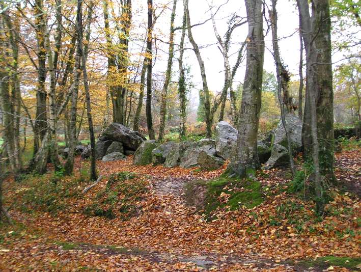
Petite Roche allée couverte submitted by thecaptain on 27th Dec 2004. Allée Couverte de la Petite Roche, Rocheville, Normandie.
Most of the remains are seen here in this view from the southeast.
(View photo, vote or add a comment)
Log Text: In the woods around the village of Rocheville can be found the remains of three Allées Couverte, only one of which is marked on the IGN maps, which is known as the Allée Couverte de la Petite Roche. To the southeast of Rocheville is a wooded area known as Bois de la Grosse Roche, and in the southwest corner of this wood, almost right beside the lane, is found the Allée Couverte de la Petite Roche.
About 20 metres in length, it runs in an east west direction. The width between the stones, of which there would have been about 20 in each row, is between 1 and 1,5 metres, and the height is about the same. At the east end of the allée the end stone remains in place, while at the west end it is open, but with a large stone across the rows about 3 metres distant, possibly a removed roofstone. About 5 cover stones remain in position, in two groups, two near the east end, and the other three nearer to the west end. There are many other stones lying around in the wood, probably some parts of the monument.
Petit-Vieux-Sou
Trip No.202 Entry No.31 Date Added: 26th Mar 2020
Site Type: Passage Grave
Country: France (Pays de la Loire:Mayenne (53))
Visited: Yes on 29th Apr 2005. My rating: Condition 5 Ambience 4 Access 4
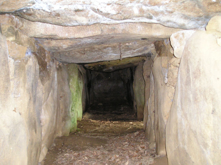
Petit-Vieux-Sou submitted by TheCaptain on 10th May 2005. Le Petit-Vieux-Sou allée couverte, Brecé, Mayenne.
Looking along the inside of this splendid monument, the entrance can be seen on the right where the light is coming in.
(View photo, vote or add a comment)
Log Text: A little Mayenne Allée Couverte 2.5 km southeast of Brecé village which was has been restored. It is found in a little wooded area a few hundred metres south of the country lane by the farm of the same name and is sort of built into the side of a little hillock just above a little stream.
The main chamber consists of 9 capstones on 10 pairs of stones aligned on a bearing of 316° with the lateral entrance central on the south western side. The external dimensions are about 12 m by 4 m with the internal chamber about 1.5 metres in width and height and fully contained within its mound which is built of stone blocks with drystone walling on the SW side and the two ends.
There are quite a few other large stones scattered around in the pleasant little glade full of bluebells and other flowers at the time of my visit which was my first megalithic site in my new campervan. The first of many.
