 with our Megalithic Portal iPhone app")


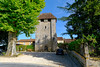
<< Our Photo Pages >> Peyre Levade (Condat) - Burial Chamber or Dolmen in France in Aquitaine:Dordogne (24)
Submitted by TheCaptain on Saturday, 16 April 2005 Page Views: 3874
Neolithic and Bronze AgeSite Name: Peyre Levade (Condat) Alternative Name: dolmen de Fouret, Dolmen de Peyre Levade de FouretCountry: France Département: Aquitaine:Dordogne (24) Type: Burial Chamber or Dolmen
Nearest Town: Périgueux Nearest Village: Condat-sur-Trincou
Latitude: 45.370185N Longitude: 0.701510E
Condition:
| 5 | Perfect |
| 4 | Almost Perfect |
| 3 | Reasonable but with some damage |
| 2 | Ruined but still recognisable as an ancient site |
| 1 | Pretty much destroyed, possibly visible as crop marks |
| 0 | No data. |
| -1 | Completely destroyed |
| 5 | Superb |
| 4 | Good |
| 3 | Ordinary |
| 2 | Not Good |
| 1 | Awful |
| 0 | No data. |
| 5 | Can be driven to, probably with disabled access |
| 4 | Short walk on a footpath |
| 3 | Requiring a bit more of a walk |
| 2 | A long walk |
| 1 | In the middle of nowhere, a nightmare to find |
| 0 | No data. |
| 5 | co-ordinates taken by GPS or official recorded co-ordinates |
| 4 | co-ordinates scaled from a detailed map |
| 3 | co-ordinates scaled from a bad map |
| 2 | co-ordinates of the nearest village |
| 1 | co-ordinates of the nearest town |
| 0 | no data |
Be the first person to rate this site - see the 'Contribute!' box in the right hand menu.
Internal Links:
External Links:
I have visited· I would like to visit
alchemille visited on 2nd Aug 2013 - their rating: Cond: 2 Amb: 2 Access: 1 The dolmen of Peyrelevade (raised stone in occitan ) is found in a privetly own wood before we reach the hamlet of Fouret coming from the D78, near the commune of Condat-sur-Trincou, Dordogne, France. There is an homonymous dolmen in the outskirts of Brantome, a few kms near Condat.
The capstone is red and gray; the stone is a sidérolithique, a very hard rock composed mainly of iron and silicon, found probably in the Correze department, in the Limousin region. The dolmen is partly distroyed, the capstone is tilted on a side and measures 3.40m by 2.40m.
There is a path to get to the dolmen once you enter the wood, but it is very difficult to find this path. At one time the council tried to attract punters there, but that seems to be some time ago, there are brambles everywhere and overgrown bushes. The signs are all broken and scattered about.
TheCaptain couldn't find on 17th May 2005 A couple of kilometres east of Brantôme is marked a dolmen on my ign map but despite trying hard to find it I saw no signs of anything and there was nowhere at all to park on very small country lanes to get out and have a proper look.
 (PID:110829)")
IMPORTANT NOTE: Positional co-ordinates scaled from a detailed map source
You may be viewing yesterday's version of this page. To see the most up to date information please register for a free account.
 (PID:110986)")
 (PID:269597)")
 (PID:269596)")
 (PID:269595)")
Do not use the above information on other web sites or publications without permission of the contributor.
Nearby Images from Flickr
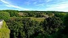


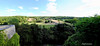
The above images may not be of the site on this page, but were taken nearby. They are loaded from Flickr so please click on them for image credits.
Click here to see more info for this site
Nearby sites
Click here to view sites on an interactive map of the areaKey: Red: member's photo, Blue: 3rd party photo, Yellow: other image, Green: no photo - please go there and take one, Grey: site destroyed
Download sites to:
KML (Google Earth)
GPX (GPS waypoints)
CSV (Garmin/Navman)
CSV (Excel)
To unlock full downloads you need to sign up as a Contributory Member. Otherwise downloads are limited to 50 sites.
Turn off the page maps and other distractions
Nearby sites listing. In the following links * = Image available
366m NNE 12° Menhir de Fouret* Standing Stone (Menhir)
2.5km SSE 151° Peyrelevade 2 (Condat)* Burial Chamber or Dolmen
3.2km WSW 252° La Pierre Levée (Brantôme)* Burial Chamber or Dolmen
6.3km SSW 210° Dolmen des Coutoux* Burial Chamber or Dolmen
6.3km NE 42° Dolmen de Puyruffet Burial Chamber or Dolmen
7.2km SW 216° Beauroulet Dolmen* Burial Chamber or Dolmen
7.7km WSW 238° Mégalithe (Valeuil) Standing Stone (Menhir)
8.3km NW 323° Menhir de Champredon* Standing Stone (Menhir)
9.5km WSW 245° Fourneau du Diable* Rock Outcrop
9.8km WSW 243° Grotte des Bernoux Cave or Rock Shelter
10.2km WSW 241° Grotte du Trou de la Chèvre Cave or Rock Shelter
10.4km NE 39° Grotte de Villars* Cave or Rock Shelter
13.1km NW 324° Grotte de la Font-Bargeix Cave or Rock Shelter
13.2km WSW 249° La Monerie menhir* Standing Stone (Menhir)
13.6km ESE 122° Menhir de La Pelletenie* Standing Stone (Menhir)
13.6km ESE 123° Dolmen de Sorges* Burial Chamber or Dolmen
13.8km NE 54° Grotte des Fraux Cave or Rock Shelter
13.9km WSW 258° Peyre d'Ermale* Burial Chamber or Dolmen
13.9km ESE 122° Dolmen de la Pelletenie* Burial Chamber or Dolmen
14.1km WSW 252° Dolmen de Peyrelevade (Paussac)* Burial Chamber or Dolmen
14.2km W 262° Le Breuil* Burial Chamber or Dolmen
15.7km SW 232° Pierre Plantée (Lisle)* Standing Stone (Menhir)
15.9km NW 319° Bernardieres* Stone Row / Alignment
18.0km NW 310° La Roderie* Standing Stone (Menhir)
18.3km S 187° Raymonden* Cave or Rock Shelter
View more nearby sites and additional images


 We would like to know more about this location. Please feel free to add a brief description and any relevant information in your own language.
 Wir möchten mehr über diese Stätte erfahren. Bitte zögern Sie nicht, eine kurze Beschreibung und relevante Informationen in Deutsch hinzuzufügen.
 Nous aimerions en savoir encore un peu sur les lieux. S'il vous plaît n'hesitez pas à ajouter une courte description et tous les renseignements pertinents dans votre propre langue.
 Quisieramos informarnos un poco más de las lugares. No dude en añadir una breve descripción y otros datos relevantes en su propio idioma.