Contributory members are able to log private notes and comments about each site
Sites TheCaptain has logged. View this log as a table or view the most recent logs from everyone
Pierre-de-Nézan
Trip No.204 Entry No.83 Date Added: 16th Jul 2020
Site Type: Standing Stone (Menhir)
Country: France (Pays de la Loire:Maine-et-Loire 49)
Visited: Yes on 15th Jul 2005. My rating: Condition 2 Ambience 3 Access 3
Pierre-de-Nézan submitted by ocdolmen on 16th Sep 2009. Nézan menhir
(View photo, vote or add a comment)
Log Text: This stone is a longish walk, more than a kilometre, from anywhere, and can be found near to a junction of forest tracks. It is about 3 metres long, with a slanted top, but is leaning so much that I'd say it was fallen ! Thankfully most of the walk is in the shade, it is so hot and humid today, 42° on the thermometer in the van.
Pierre-aux-Fées (St-Micaud)
Trip No.204 Entry No.202 Date Added: 26th Aug 2020
Site Type: Standing Stone (Menhir)
Country: France (Bourgogne:Saône-et-Loire (71))
Visited: Yes on 2nd Aug 2005. My rating: Condition 4 Ambience 3 Access 5
Pierre-aux-Fées (St-Micaud) submitted by thecaptain on 5th Sep 2006. The Pierre-aux-Fées is about 7 metres tall, and has perhaps got some carvings on it.
(View photo, vote or add a comment)
Log Text: This is a very large menhir right beside the D.28 road in front of a large house in the village of St-Micaud. I would estimate it to be about 7 metres tall, but its not easy to tell as it is in the private garden and surrounded by a hedge. The menhir is of rectangular shape, nd has very uneven surfaces, and has perhaps got some carvings on it.
Pierre-aux-Fées
Date Added: 18th Sep 2010
Site Type: Rock Art
Country: France (Auvergne:Puy-de-Dôme (63))
Visited: Yes on 5th Sep 2006
Pierre-aux-Fées (St-Micaud) submitted by thecaptain on 5th Sep 2006. The Pierre-aux-Fées is about 7 metres tall, and has perhaps got some carvings on it.
(View photo, vote or add a comment)
Log Text: None
Pierre Trouée de l'allée couverte d'Aizier
Trip No.212 Entry No.18 Date Added: 30th Mar 2020
Site Type: Passage Grave
Country: France (Normandie:Eure (27))
Visited: Yes on 27th Dec 2012. My rating: Condition 4 Ambience 4 Access 5
Pierre Trouée de l'allée couverte d'Aizier submitted by theCaptain on 30th Dec 2012. This wonderful holed stone is today found nicely presented just outside the little church of the village of Aizier, right on the banks of the River Seine. The stone is the portholed entry stone from a now destroyed allée couverte, destroyed during the making of a road.
The stone is about 1.7 metres tall and wide, thickness 22 cm, but the important dimension is that of the circular hole, which is diameter 47 cm, and yes, I did manage to crawl through it!
(View photo, vote or add a comment)
Log Text: This wonderful holed stone is today found nicely presented (since 1976) just outside the little church of the village of Aizier, right on the banks of the River Seine not too far upstream from the Tancarville Bridge, a few miles inland from Le Havre.
The stone is the remains of the portholed entry stone from a now destroyed allée couverte, which was destroyed during the making of the road to Bourneville sometime in the 19th century. The stone is about 1.7 metres tall and wide, with thickness 22 cm, but the important dimension is that of the circular hole, which is of diameter 47 cm, and yes, I did manage to crawl through it!
This type of allée couverte was fairly common in this region, and dates to the final neolithic, -3500 BC to -2800 BC.
Pierre Tourneresse, Cairon
Trip No.202 Entry No.5 Date Added: 25th Mar 2020
Site Type: Chambered Tomb
Country: France (Normandie:Calvados (14))
Visited: Yes on 23rd Apr 2005. My rating: Condition 4 Ambience 4 Access 4
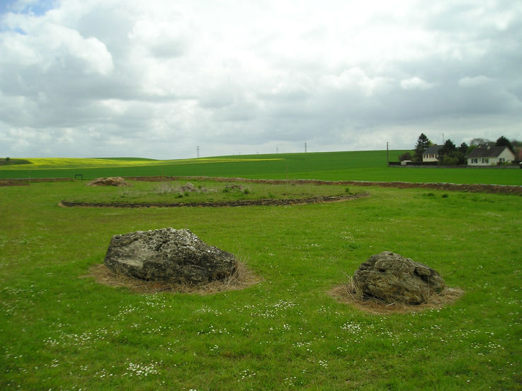
Pierre Tourneresse, Cairon submitted by thecaptain on 28th Apr 2005. Pierre Tourneresse, Cairon. Seen here looking towards the remains of the large round burial mound from beyond the two large stones which are the remains of the capstone from the main chamber - removed and destroyed by the Germans during the '39-45 war.
(View photo, vote or add a comment)
Log Text: I wasn’t expecting to find much here if anything at all as all the information I had of this site was a menhir symbol on my ign map. But as I was passing I decided to have a look anyway and luckily stopped to look at my map right by a little road at the east of the southern end of the village with a sign to “Pierre Tourneresse”. So I followed it down to the end of a little modern housing estate and parked. A further signpost at the end of the road points to Pierre Tourneresse 300 metres distant. Turn left here and stick to the back of the houses rather than go straight on up the hill.
What a lovely site this is. In a little dip down near the stream is a newly made and signposted enclosure which at the time of my visit was still under construction with a ring of trees being planted well around the outside of it. Inside the enclosure is the remains of a large approximately round cairn which has a diameter of about 19 metres and is edged all around with dry stone walling within which are two chambers.
The main chamber is large stone lined chamber in approximately the middle of the cairn which has a seven metre long entrance passage which exits to the east of the cairn at a bearing of 100° magnetic. The chamber is approximately rectangular dimensions about 4 to 5 metres in length by 3 metres in width and is made with large upright slabs with drystone walling between. At various positions around this large chamber there seem to be smaller alcoves or features. The second much smaller chamber opens to the west side and is positioned approximately opposite to the main chamber entrance with an alignment of 269°. It is about 3.5 metres long and opens up to about 2 metres in width at its maximum. It is made with drystone walling only and has a ledge of some sort along its northern side.
Outside the cairn at a distance of about 15 metres in a northwesterly direction are two very large stones. I wondered whether these were once menhirs which marked the position of the cairn (these northern French cairns are often associated with menhirs) and which would explain the marking of menhir on the ign maps. Looking at these stones more closely however suggested that it is much too wide to have been a menhir so I wondered whether the stones were the remains of the chamber capstone. I spent quite a lot of time here the place seemed to give off a nice happy atmosphere which was probably helped by the fact that for once one of these much neglected ancient Normandy monuments is being lovingly cared for and looked after what was probably many years of neglect.
As I was leaving I met a man walking his dog and asked if he knew anything about the site. By an amazing stroke of luck I had met one of the few people in France who has an interest in these ancient sites and who collects flint artefacts ! Despite the language problems we talked for about half an hour about things. He told me that the cairn had been much more complete up until the war during which the Germans had used it as a shelter and gun emplacement. As they were leaving after the D-Day invasion they went about destroying it and the two large stones are indeed the remains of the capstone to the main chamber. He also told me that an excavation of the site was done 5 years ago and the restoration has been going on since then.
We got on to discussing other sites in the region and other than the various sites I knew about (he was surprised indeed to find an Englishman who knew anything about any of these places and seemed very interested when I told him I intended to write a book) and he told me of a menhir nearby he knew which was destroyed only a couple of years ago by a farmer who didn’t want it in the middle of one of his fields. He also showed me on my map a couple of places where he goes to find flint items one of which he called a quarry. He said that if I went to one of these places he showed me then if the fields were recently ploughed I would almost certainly find some worked flint items and that he had a collection of over 700 items. He also then told me in detail how to find the two polisher stones near Mont Joly which was of great interest as I would probably not have even looked if I had no detailed information to go on. It was very nice to meet a man like this particularly on my first real day of French stonehunting and it made me think that the whole trip is going to go well.
Pierre Tourneresse (Gouvix)
Trip No.202 Entry No.8 Date Added: 25th Mar 2020
Site Type: Standing Stone (Menhir)
Country: France (Normandie:Calvados (14))
Visited: Couldn't find on 23rd Apr 2005
Pierre Tourneresse (Gouvix) submitted by Rida on 29th Jan 2011. Site in Normandie:Calvados (14) France
(View photo, vote or add a comment)
Log Text: Not marked on my ign map and finding no map within the village I gave up without really trying to find the supposed menhir near here. I believe it is in the grounds of the local chateau and wasn’t going to spend a lot of time being unable to find it.
Pierre Tournante (Bosgouet)
Trip No.202 Entry No.97 Date Added: 30th Mar 2020
Site Type: Burial Chamber or Dolmen
Country: France (Normandie:Eure (27))
Visited: Couldn't find on 4th May 2005
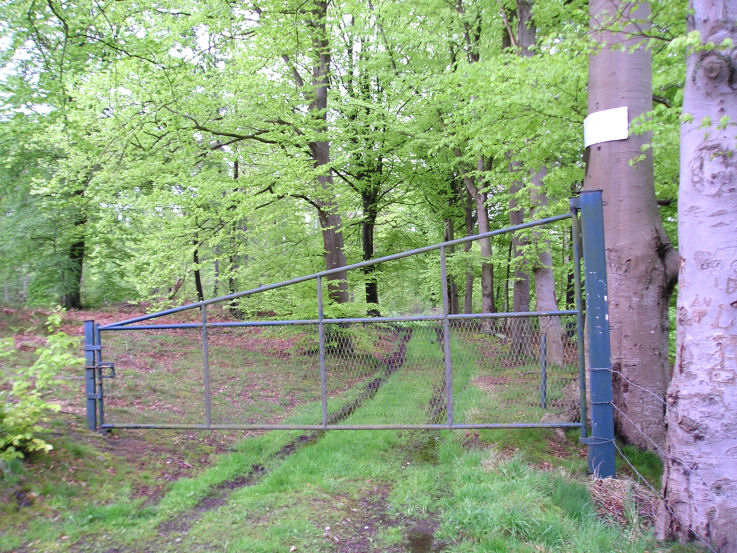
Pierre Tournante (Bosgouet) submitted by TheCaptain on 6th May 2005. Pierre Tournante, Bosgouet, Eure.
When I got there I found that the track through the forest to get to it had been gated off, with lots of barbed wire and keep out notices everywhere, so I didn’t get to visit this one.
(View photo, vote or add a comment)
Log Text: Marked on my ign map as a megalithic monument. When I got there I found that the track through the forest to get to it had been gated off with lots of barbed wire and keep out notices everywhere so I didn’t get to investigate.
Pierre Tabulaire de la Bataille
Trip No.204 Entry No.23 Date Added: 6th Jul 2020
Site Type: Burial Chamber or Dolmen
Country: France (Bretagne:Morbihan (56))
Visited: Yes on 11th Jul 2005. My rating: Condition 3 Ambience 4 Access 3
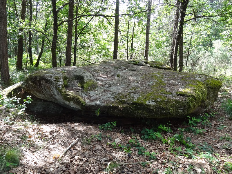
Pierre Tabulaire de la Bataille submitted by johnstone on 1st Apr 2018. The big megalith in the wood, June 22, 2012
(View photo, vote or add a comment)
Log Text: This is a massive slab of rock deep in the forest, found by following a trackway which now has a private sign on it, but I went for a look anyhow. I would think it is a natural slab of granite with its dimensions 10 metres by up to 5 metres, but it would appear to have been used as a capstone to a burial chamber under the eastern end, which has been dug underneath and surrounded with a couple more slabs. Whatever it is, this is a nice place to find.
Pierre qui Vire (Russelet)
Trip No.203 Entry No.267 Date Added: 24th Apr 2020
Site Type: Standing Stone (Menhir)
Country: France (Pays de la Loire:Vendée (85))
Visited: Yes on 6th Jun 2005. My rating: Condition 4 Ambience 3 Access 5

Pierre qui Vire (Russelet) submitted by thecaptain on 10th Dec 2005. Pierre qui Vire (Russelet)
I thought I'd found a stone row here, but it turns out that the other stones lined up with it in the field are relatively modern placements by the local farmers as field clearance.
(View photo, vote or add a comment)
Log Text: The Pierre qui Vire is a nice lichen covered stone, about 4 metres tall, 3 metres wide, and made from Gris rock - the only large menhir in this region which is, all others being made from granite.
The Pierre qui Vire, or the turning stone, is said to turn around each night, either at midnight, or the first call of a cockerel. I thought I'd found a stone row here, but it turns out that the other stones lined up with it in the field are relatively modern placements by the local farmers as field clearance.
Pierre Potelée
Trip No.205 Entry No.7 Date Added: 13th Oct 2020
Site Type: Standing Stone (Menhir)
Country: France (Pays de la Loire:Sarthe (72))
Visited: Yes on 29th Aug 2005. My rating: Condition 3 Ambience 3 Access 4
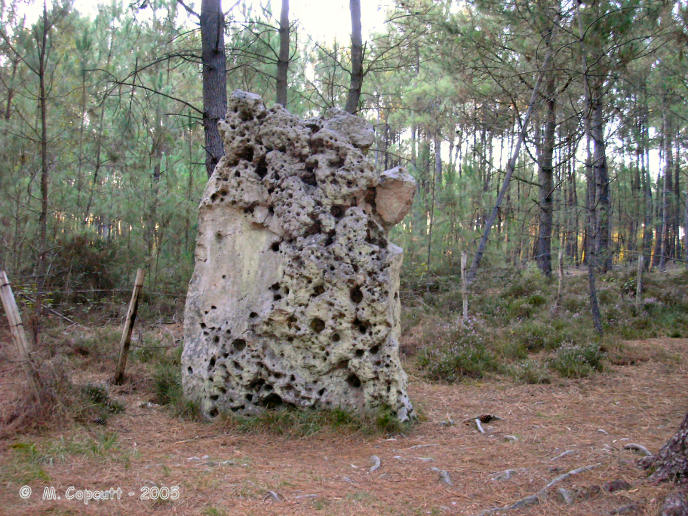
Pierre Potelée submitted by thecaptain on 22nd Feb 2006. This menhir, in the forest to the northeast of La Fleche in Sarthe, is a slab standing on its end, between 2.5 and 3 metres tall, and 2 metres wide, with many holes on one side.
(View photo, vote or add a comment)
Log Text: This stone is about half a kilometre east of the Mere et Fille stones in the forest and is also signposted. I parked in a parking area near to the signpost and walked for several kilometres before returning to my van having found nothing except for more signposts at the other end of the forest track pointing back from where I had come. As I got back to the van, I could see the stone, less than 100 metres from where I had parked, down a different track ! The stone is a slab on its end, between 2.5 and 3 metres tall, and 2 metres wide, with many holes on one side.
Pierre Pointue (Paimboeuf)
Trip No.203 Entry No.302 Date Added: 26th Apr 2020
Site Type: Standing Stone (Menhir)
Country: France (Pays de la Loire:Loire-Atlantique)
Visited: Yes on 8th Jun 2005. My rating: Condition 2 Ambience 2 Access 4
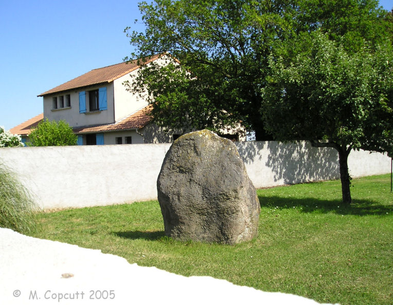
Pierre Pointue (Paimboeuf) submitted by thecaptain on 17th Nov 2009. Pierre Pointue (Paimboeuf) is about 1.6 metres tall, and can be seen over the top of the wall.
(View photo, vote or add a comment)
Log Text: In the southeastern area of the town of Paimboeuf, amongst a housing estate, can be found a Rue de la menhir. Following this road from the main road, there is a right angled bend to the right, and a couple more older houses before you get to a building site for new houses. The menhir is somewhere down here, but well enough hidden that I couldnt find it. I asked an old gent who was out in his garden where the menhir was. He was delighted that I was there looking for it, and he showed me to a nearby house with a large wall around the garden, and pointed it out within the garden. He said he had complained to the Mairie several times about the new owner of the house building the wall, and hiding the menhir away from view, saying that as a historic monument it should be readily visible to all. It is about 1.6 metres tall, and can be seen over the top of the wall.
Pierre Plantée de Lacaune
Trip No.205 Entry No.125 Date Added: 10th Nov 2020
Site Type: Sculptured Stone
Country: France (Midi:Tarn (81))
Visited: Yes on 16th Sep 2005. My rating: Condition 5 Ambience 5 Access 4

Pierre Plantée de Lacaune submitted by peterpf on 29th Jul 2006. The menhir in a front view. Only some of the engravings are still visible.
(View photo, vote or add a comment)
Log Text: A couple of kilometres to the east of Lacaune, along the D.622 road to Moulin-Mage, park just over the Col de la Croix-de-Deux-Sous, just after the big warehouse. Its then a short walk to this masculine statue-menhir, the largest in Europe, standing in a nice green field looking out towards the mountains.
This would be a beautiful stone even without the engravings, a lovely sparkly granite 3.5 metres tall, 2 metres wide and just 40 cm thick It has a lovely smoothed shape, and has got beautiful lichens growing on it. Unfortunately, these lichens and its sunny south facing position serve to obscure the details of the fine chap of whom this is a statue of. In the mid-day sun, while I was here, it was hard to make out the details, but his two legs, belt and "objet" could be seen, and perhaps his two arms. But these wont show in any of my photos. This is a beautiful spot indeed, but perhaps this fellow would be better preserved indoors ?
Pierre Plantée (Lisle)
Trip No.203 Entry No.62 Date Added: 5th Apr 2020
Site Type: Standing Stone (Menhir)
Country: France (Aquitaine:Dordogne (24))
Visited: Yes on 17th May 2005. My rating: Condition 2 Ambience 3 Access 5
Pierre Plantée (Lisle) submitted by theCaptain on 17th Jan 2011. As I was driving south along the D78 road coming into Lisle, I saw a sign saying Pierre Plantée and there was a stone about a metre high stood just by the roadside.
I cant be sure whether this is the actual Pierre Plantée referred to or indeed whether it is ancient but it isn’t new !
(View photo, vote or add a comment)
Log Text: As I was driving south along the D78 road coming into Lisle I saw a sign saying Pierre Plantée and there was a stone about a metre high stood just by the roadside. I cant be sure whether this is the actual Pierre Plantée referred to or indeed whether it is ancient but it isn’t new !
Pierre Plantée (Cosqueville)
Trip No.201 Entry No.15 Date Added: 25th Mar 2020
Site Type: Standing Stone (Menhir)
Country: France (Normandie:Manche (50))
Visited: Yes on 22nd Nov 2004. My rating: Condition 3 Ambience 3 Access 4
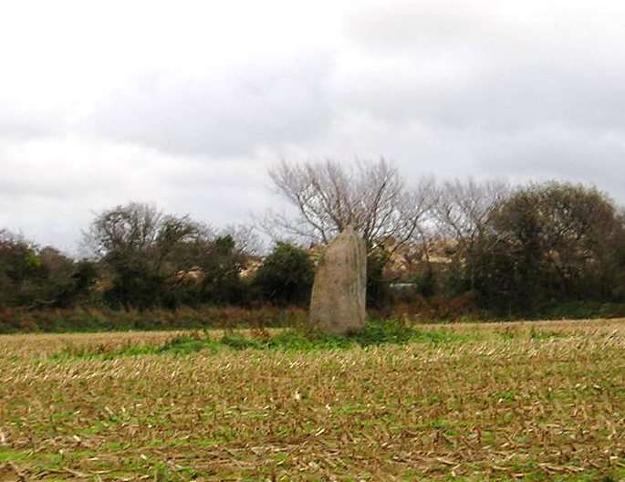
Pierre Plantée (Cosqueville) submitted by thecaptain on 30th Dec 2004. La Pierre Plantée, Cosqueville, Manche.
Side on view of this 3 metre tall stone, looking roughly south, and the quarry workings can be seen behind the hedge.
(View photo, vote or add a comment)
Log Text: In a field to the south of the road running east out of Cosqueville can be seen this large menhir, 3 metres in height. It is possible to park nearby, and I walked round the edge of a field to get a nearer view of the stone which is in the middle of a field beside a quarry. It is a nicely shaped stone, looking to be wider at the top than the bottom, with a sort of nob on the top, and with grooves running down its sides, probably due to rain erosion.
Pierre Plantée (Congénies)
Trip No.205 Entry No.195 Date Added: 26th Nov 2020
Site Type: Standing Stone (Menhir)
Country: France (Languedoc:Gard (30))
Visited: Yes on 21st Sep 2005. My rating: Condition 4 Ambience 3 Access 4

Pierre Plantée (Congénies) submitted by Nick- on 26th Apr 2007. 18/04/2007 Western face of the stone.
(View photo, vote or add a comment)
Log Text: Drive north from Aubais towards Congénies for about 1.5 km, and at the bend in the road there is a stoney track which heads off to the east. Take this track along the ridge for about 400 metres, and at a major junction of tracks, on the left, can be seen this menhir.
The stone is about 2.3 metres tall, 1.5 m wide at the base and 40cm thick, standing in amongst some very prickly undergrowth. On both faces are several carvings and engravings, from ancient to more modern graffitti. Amongst the ancient are several cupules and some crosses. There are also symbols which resemble letters or Greek symbols. A little offering of flowers had been placed into a crack in the stone when I visited, so obviously somebody still cares for this ancient stone.
Pierre Percée (Draché)
Trip No.205 Entry No.8 Date Added: 13th Oct 2020
Site Type: Standing Stone (Menhir)
Country: France (Centre:Indre-et-Loire (37))
Visited: Yes on 30th Aug 2005. My rating: Condition 5 Ambience 3 Access 4
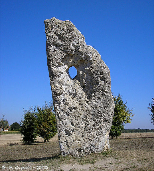
Pierre Percée (Draché) submitted by thecaptain on 15th Jan 2006. The stone is about 3.5 metres tall, slightly leaning and pointing skywards. About two thirds of the way up is an intriguing hole through the stone, oval in shape, about 25 cm by 20 cm.
(View photo, vote or add a comment)
Log Text: A few kilometres to the south of the village of Sainte-Maure-de-Touraine along the N.10, and this stone is signposted, less than a kilometre to the west along a minor road. The stone has its own little parking area and explanatory signpost, and is set in a nice open grassy area.
The stone is about 3.5 metres tall, slightly leaning and pointing skywards. About two thirds of the way up is an intriguing hole through the stone, oval in shape, about 25 cm by 20 cm, which is perhaps natural.
This menhir has many legends associated with it, and it is said that if children or babies are passed through the hole, they will be cured and immune to various diseases. There is also a legend that the stone was used for sacrifices, and that all of the parts of the sacrificial body must be passed through the hole. It is thought that it may originally have been some form of marker stone for a nearby ancient cemetery, now no longer to be seen.
Pierre Pelot
Trip No.204 Entry No.218 Date Added: 4th Sep 2020
Site Type: Standing Stone (Menhir)
Country: France (Bourgogne:Côte-d'Or (21))
Visited: Couldn't find on 4th Aug 2005
Pierre Pelot submitted by AlexHunger on 11th Jul 2010. Natural stone near the top of hill in Bourgogne hiking area which I have classed as a Menhir. A local website claims it was a Judgement Stone under the celts or Gauls. I assume, the accused sat on the stone in front of it.
(View photo, vote or add a comment)
Log Text: The village of Roche-en-Brenil is supposed to have two menhirs, but I could find no sign of either of them. It's a shame that these places do not have village maps with things marked, or any signposts like they do elsewhere. The area is covered with forests, and looks to be lots of natural granite outcrops.
Pierre Meslière
Trip No.204 Entry No.65 Date Added: 16th Jul 2020
Site Type: Ancient Village or Settlement
Country: France (Pays de la Loire:Loire-Atlantique)
Visited: Yes on 14th Jul 2005. My rating: Condition 2 Ambience 3 Access 4
Pierre Meslière submitted by Dipo on 26th Oct 2008. Site in Pays de la Loire: Loire-Atlantique:
(View photo, vote or add a comment)
Log Text: This was most unexpected, I saw a sign to this from St Géréon, so just followed the signs. There is a large rocky outcrop high above the river Loire, around which evidence of man living here has been found dating back to the paleolithic. From the neolithic period, when the settlement was extended, there was once a line of 48 menhirs running east to west. It says that today only two remain, the rest having been destroyed for roadbuilding, along with much of the natural rocky outcrop. The site was first recognised for what it was in 1878 by Pitre de L'Isle, and explored much more thoroughly by Alexandre Bernard throughout the last century. His books and studies are shown in the chateau.
Pierre Longue du Bouchet
Trip No.204 Entry No.78 Date Added: 16th Jul 2020
Site Type: Standing Stone (Menhir)
Country: France (Pays de la Loire:Maine-et-Loire 49)
Visited: Yes on 15th Jul 2005. My rating: Condition 3 Ambience 3 Access 4

Pierre Longue du Bouchet submitted by ocdolmen on 3rd Aug 2009. Pierre Longue du Boucher menhir near Gennes . Important megalithic area.
(View photo, vote or add a comment)
Log Text: A fine menhir, standing around 3.5 metres tall near the top of a hill amongst the fields and forests. Its a nice triangular shaped slab of the local sarsen like stone. It is fairly easily found with the ign 1:25000 map, a few hundred metres walk along a track from the roadside above Bouchet.
Pierre Longue de Saint-Jouan
Date Added: 29th Oct 2019
Site Type: Standing Stone (Menhir)
Country: France (Bretagne:Ille-et-Vilaine (35))
Visited: Yes on 17th Oct 2010
Pierre Longue de Saint-Jouan submitted by TheCaptain on 17th Oct 2010. Despite the menhir being so big, it still manages to play a game of hide and seek before finding it along chestnut lined trackways through fields of maize!
(View photo, vote or add a comment)
Log Text: None
