Contributory members are able to log private notes and comments about each site
Sites TheCaptain has logged. View this log as a table or view the most recent logs from everyone
Craddock Moor circle
Date Added: 27th Aug 2025
Site Type: Stone Circle
Country: England (Cornwall)
Visited: Yes on 20th Sep 2009. My rating: Condition 3 Ambience 4 Access 3
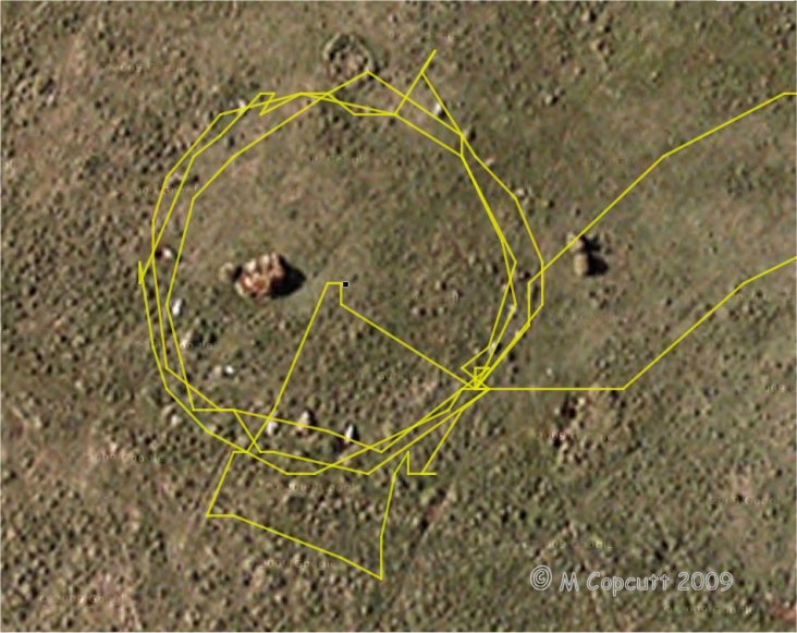
Craddock Moor circle submitted by thecaptain on 22nd Sep 2009. gps track plot of my wanderings round Craddock Moor stone circle on Sunday. Many of the stones can be seen in the picture.
I use an ageing Garmin etrex Venture pocket reciever, and the track is plotted out using GPSVisualizer, with only a few minutes fiddling.
I find it amazing the results that can now be obtained for things like this, using cheap, readily available technology, in a pocketsized device.
(View photo, vote or add a comment)
Log Text: After turning off the track near to the cairn, and heading out over the open moor, I found the circle easily, having headed straight to it from judging things looking at the map, and not using the GPS. I counted about 17 or 18 stones plus gaps on my first time round, but perhaps 19 or 20 next time round including lumps under tufts of grass. The circle is about 42 paces in diameter, with about 5 paces between each stone. When here, in September at the end of the summer, the grass and suchlike was very long, making most of the stones difficult to spot, so I first walked around the outside checking out what I could find. Then I walked around again taking photos, hence some excursions from the circle. I then went to the middle to survey the scene as a whole before looking for somewhere to sit and eat my pasty for lunch, which I would have liked to be the middle of the circle, but there was only long grass there, so a convenient and comfortable looking stone at the southeast did the job. I looked at my gps and was amazed at the nice circle on the screen, so thought I would "draw" another circle on it before I left !
Craddock Moor circle
Date Added: 27th Aug 2025
Site Type: Stone Circle
Country: England (Cornwall)
Visited: Yes on 20th Jun 2025. My rating: Condition 3 Ambience 4 Access 3

Craddock Moor circle submitted by mattimpey on 9th Dec 2008. Three of the most prominant prostrate stones look East. The large bush is in the middle of the stone circle.
(View photo, vote or add a comment)
Log Text: Get to Minions eventually, but find that the Cheesewring pub has burned down and is all abandoned. Get a quick pasty at the Minions village shop, before setting off for a walk to the Craddock Moor stone circle, as I havent been there for ages. Its very hot and I am extremely weary, but I get there and manage to have a look amidst a large group of cows. It seems easier to find this time, with the stones more clear, possibly because its less overgrown.
Craddock Moor embanked avenue
Date Added: 18th Sep 2010
Site Type: Misc. Earthwork
Country: England (Cornwall)
Visited: Yes on 7th Oct 2009
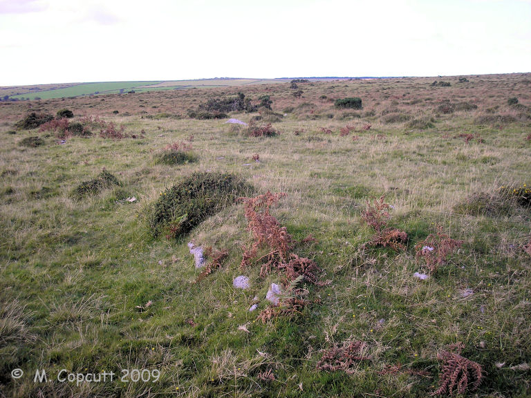
Craddock Moor embanked avenue submitted by thecaptain on 7th Oct 2009. The banks are still about half a metre to a metre in height, and in places seem to have got some stone slabs along the inner edges, perhaps once making a sort of kerb.
(View photo, vote or add a comment)
Log Text: None
Craddock Moor platform cairn
Date Added: 25th Aug 2025
Site Type: Cairn
Country: England (Cornwall)
Visited: Yes on 20th Sep 2009. My rating: Condition 3 Ambience 4 Access 3

Craddock Moor platform cairn submitted by thecaptain on 1st Oct 2009. View northeast over Craddock Moor platform cairn, and right across the middle of Bodmin Moor.
Cornwall's very own mountain Brown Willy is in the distance.
(View photo, vote or add a comment)
Log Text: Following the track out towards Golddiggings quarry, there is a cairn marked at about the top of the local moorland, about where I need to head off southwest to find the stone circle. The cairn is clear to see, and is quite a big but low flat circle, probably up to a metre high above the surrounding moor. Much of it is covered by ferns, and this morning is surrounded by guard cows, some with vicious looking horns, which kept me away on the way out. The views from here are superb, with Brown Willy to be seen off to the northwest, and Sharptor and Stowes Pound very clear to the northeast. It is beautiful out here on the open moor. Turns out this is a circular platform cairn with peripheral berm, 24m in diameter for the cairn and up to 31m in diameter with its berm. English Heritage Scheduled Monument 15056 http://www.magic.gov.uk/rsm/15056.pdf
Craddock Moor platform cairn
Date Added: 25th Aug 2025
Site Type: Cairn
Country: England (Cornwall)
Visited: Yes on 20th Jun 2025. My rating: Condition 3 Ambience 4 Access 3
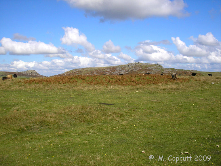
Craddock Moor platform cairn submitted by thecaptain on 1st Oct 2009. View east over Craddock Moor platform cairn and its berm.
Sharptor and Stowe's Hill in the background.
(View photo, vote or add a comment)
Log Text: I get to Minions eventually, but find that the Cheesewring pub has burned down and is all abandoned. Get a quick pasty at the Minions village shop, before setting off for a walk to the Craddock Moor stone circle, as I havent been there for ages. Its very hot and I am extremely weary, but I get there and manage to have a look amidst a large group of cows. Before the circle is the platform cairn which is clear to see all covered in ferns, and is quite a big but low flat circle, probably up to a metre high above the surrounding moor.
Craddock Moor stone row
Date Added: 18th Sep 2010
Site Type: Stone Row / Alignment
Country: England (Cornwall)
Visited: Yes on 22nd Sep 2009

Craddock Moor stone row submitted by thecaptain on 22nd Sep 2009. gps track plot of my wanderings round Craddock Moor, along the embanked avenue and then the stone row on Sunday.
I use an ageing Garmin etrex Venture pocket reciever, and the track is plotted out using GPSVisualizer, with only a few minutes fiddling.
I find it amazing the results that can now be obtained for things like this, using cheap, readily available technology, in a pocketsized device.
(View photo, vote or add a comment)
Log Text: None
Craddock Moor Stone Setting
Date Added: 18th Sep 2010
Site Type: Standing Stones
Country: England (Cornwall)
Visited: Yes on 30th Sep 2009
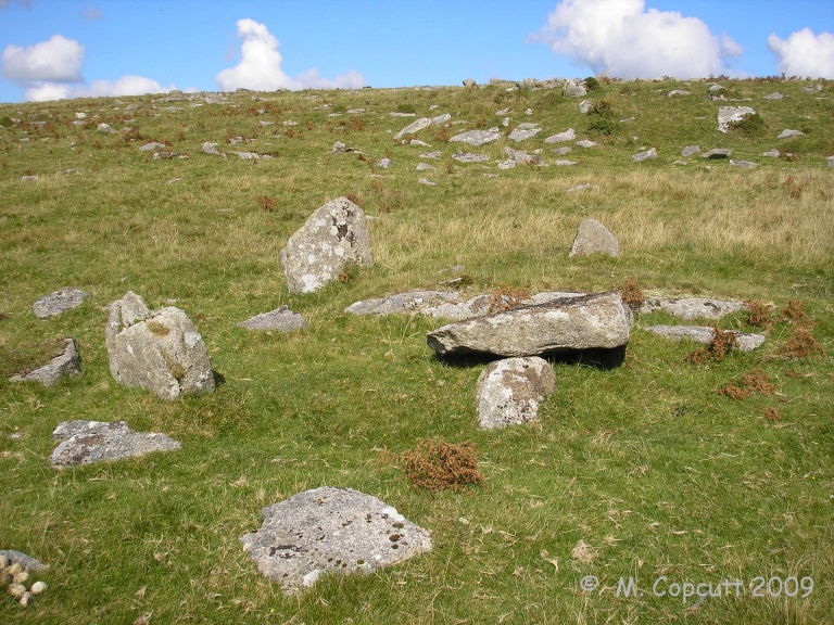
Craddock Moor Stone Setting submitted by thecaptain on 30th Sep 2009. On the rocky slopes to the southwest of Goldiggings Quarry, a small stone setting is to be found. The obvious stones which are first seen are three or four standing stones about half a metre tall making a sort of circle, with a slab lying on top of a further stone within it.
(View photo, vote or add a comment)
Log Text: None
Craig-Y-Fan Ddu
Date Added: 18th Sep 2010
Site Type: Multiple Stone Rows / Avenue
Country: Wales (Powys)
Visited: Yes on 14th Nov 2007

Craig-Y-Fan Ddu submitted by TheCaptain on 14th Nov 2007. On the southern slopes of Craig-Y-Fan Ddu are marked Stones on the 1:25000 OS map. They reminded me very much of the Exmoor stone settings.
View downhill towards the east.
(View photo, vote or add a comment)
Log Text: None
Cranbrook Castle
Date Added: 28th Sep 2020
Site Type: Hillfort
Country: England (Devon)
Visited: Saw from a distance on 26th Feb 2019
Cranbrook Castle submitted by TheCaptain on 28th Feb 2019. Cranbrook Castle as seen from Butterdon Down
(View photo, vote or add a comment)
Log Text: Cranbrook Castle hillfort can be seen to the northwest of Butterdon Down. I decide that with it only being February, and with it getting dark by 5:00pm, I will not visit, but go for a pint in the Union Inn at Moretomhampstead before heading out to Houndtor.
Crane Castle
Date Added: 24th Jul 2025
Site Type: Promontory Fort / Cliff Castle
Country: England (Cornwall)
Visited: Yes on 15th Jun 2025. My rating: Condition 3 Ambience 4 Access 3
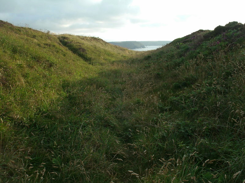
Crane Castle submitted by Bladup on 20th Jul 2015. Defences at Crane Castle.
(View photo, vote or add a comment)
Log Text: Walking a loop along the coast path from Portreath, I stopped above Basset's Cove for lunch before turning inland, before reaching the remains of Crane Castle fort. Despite most of the headland having now been claimed by the sea, I was sure I could see remains of ramparts.
Cranham Corner Earthworks
Date Added: 10th Jun 2021
Site Type: Misc. Earthwork
Country: England (Gloucestershire)
Visited: Yes on 31st May 2021. My rating: Condition 3 Ambience 3 Access 4
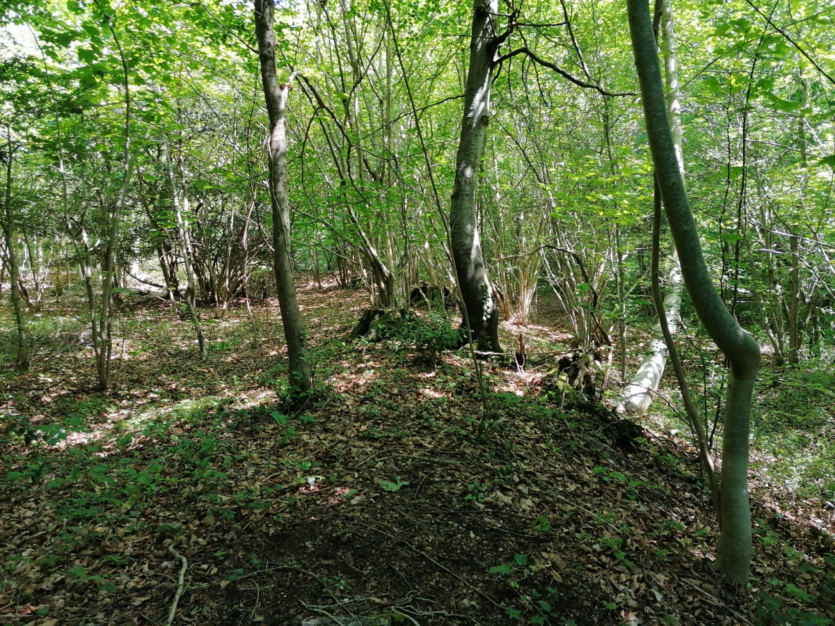
Cranham Corner Earthworks submitted by TheCaptain on 10th Jun 2021. Small earthworks within the woodland at Cranham Corner.
I am not convinced they would have been of much use defensively, being on a slight slope not at the top of the hill, and not very large.
(View photo, vote or add a comment)
Log Text: Walking a Cooper's Hill Circuit of the Cotswold Way from Cranham, and first off had a look at these small earthworks. I am not convinced they would have been of much use defensively, being on a slight slope not at the top of the hill, and not very large.
Créac'h Gallic
Trip No.203 Entry No.528 Date Added: 28th May 2020
Site Type: Passage Grave
Country: France (Bretagne:Finistère (29))
Visited: Yes on 21st Jun 2005. My rating: Condition 4 Ambience 3 Access 5
Créac'h Gallic submitted by TheCaptain on 17th Apr 2011. Here are the remains of a fairly large megalithic structure, but it looks to be in a bit of a precarious state. Warning signs and a fence warn of climbing on or near to the stones.
(View photo, vote or add a comment)
Log Text: Here are the remains of a fairly large dolmen, but it looks to be in a bit of a precarious state. Warning signs and a fence warn of climbing on or near to the stones. The basic chamber is about 4 metres by 2 metres and 2 metres high, with a single capstone resting (just) on three support stones. It looks like a fourth support has recently broken and fallen, and it looks most precarious and that it could fall at any time.
Strangely there are many large slabs around the outside, making a sort of wall, I cannot really make this out at all. Seems it was once a large allée couverte with a peristalith surrounding its mound, some of which still survives. But its a bit difficult to fully make out and understand, and has no doubt been damaged in the past with the construction of the farms and the lanes.
There are many other large stones laying around, I need to try and look this one up. Now I know what it is, it seems obvious what the remains are.
Créac’h-ar-Vrenn
Trip No.203 Entry No.535 Date Added: 29th May 2020
Site Type: Passage Grave
Country: France (Bretagne:Finistère (29))
Visited: Yes on 22nd Jun 2005. My rating: Condition 3 Ambience 3 Access 4
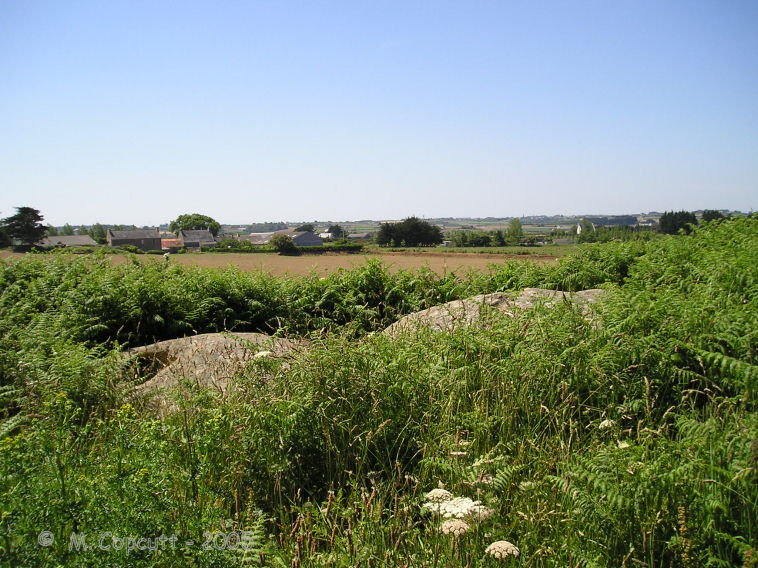
Créac’h-ar-Vrenn submitted by thecaptain on 22nd Jan 2009. What I found in 2005, behind the house at the top of the hill beside the water tower, was two rounded looking granite blocks.
With all the fences and undergrowth it was impossible to see if the stones were resting on any kind of supports, but these stones are certainly in the right position for where it is marked on the map.
(View photo, vote or add a comment)
Log Text: I am not 100% sure that I found this. What I possibly found is just some natural rocks. I looked all over the place and asked a couple of people, who both pointed me in the other direction away from their house towards the others. Despite signposts to it down the same lane as the menhir, there was no further evidence for it down there, but the new house being built is probably where the path went.
What I did find, behind the house at the top of the hill beside the water tower, was two rounded looking granite blocks, but it is possible that they have been placed there. With all the fences and undergrowth it was impossible to see if the stones were resting on any kind of supports, but these stones are certainly in the right position for where it is marked on the map.
Crec'h Quillé
Trip No.203 Entry No.569 Date Added: 3rd Jun 2020
Site Type: Passage Grave
Country: France (Bretagne:Côtes-D'Armor (22))
Visited: Yes on 24th Jun 2005. My rating: Condition 4 Ambience 3 Access 4
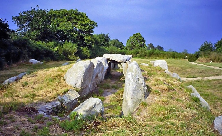
Crec'h Quillé submitted by greywether on 26th Jun 2005. A well-preserved allee-couverte with entrance, E/W chamber and mound. Art on one of the chamber stones opposite the entrance.
Photo looking E, taken June 1994.
(View photo, vote or add a comment)
Log Text: This allée couverte to the south of Perros Guirec is situated just to the east of the busy D.788 dual carriageway, and signposted from it, but most people will go whizzing straight past. From the parking area beside the main road, it is just a couple of hundred metres, but is walking access only. It's set in a nice little plot, probably originally intended for a house when it was discovered in about 1960.
It is surprisingly complete except for the capstones, and still has most of its surrounding mound and outer peristalith of alternating slabs and drystone walling. This is a rarity in these parts, a lateral entry allée couverte, with the main chamber running east west at 073°, and the entrance about two thirds the way along on the southern side.
The chamber is about 15 metres in length, by 1.7 metres width, but its surrounding mound is much larger. Just inside the main chamber, opposite to the entrance, is a smoothed and carved slab, which on one face, facing into the chamber, contains a pair of "breasts" with a large collar or crossed arms underneath. The adjacent face, which faces towards the smaller end of the monument, appears to have a "crosse" shape engraved on it. At this point are two capstones, which no doubt helped to preserve the engravings here. There is the base of a large stone just outside the entry, which is thought to be the base of an indicator menhir. The tumulus has been dated to about 2500BC.
I was going to drive past this myself in a rush to get somewhere else, but I am very glad I did stop to see it, and my visit lasted over an hour, which means I will be late to camp again tonight. A very nice monument.
Créchaudes Dolmen
Trip No.203 Entry No.272 Date Added: 24th Apr 2020
Site Type: Burial Chamber or Dolmen
Country: France (Pays de la Loire:Vendée (85))
Visited: Yes on 6th Jun 2005. My rating: Condition 2 Ambience 2 Access 4

Créchaudes dolmen submitted by thecaptain on 13th Dec 2005. Créchaudes dolmen
This dolmen is either a wreck, not much more than several stones in a field, or alternatively, it may still be in its mound, of which there is an overgrown example at the side of the field.
(View photo, vote or add a comment)
Log Text: Unless I somehow missed this dolmen, it is a wreck, not much more than several stones in a field. Alternatively, it may still be in its mound, of which there is an overgrown example at the side of the field.
Creswell Crags
Date Added: 30th Aug 2025
Site Type: Cave or Rock Shelter
Country: England (Derbyshire)
Visited: Would like to visit
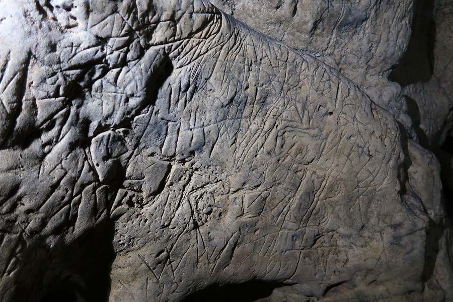
Creswell Crags submitted by dodomad on 15th Feb 2019. The biggest concentration of protective marks ever found in British caves has been discovered at Creswell Crags in the East Midlands. The caves are home to the only Ice Age Rock art in Britain.
The marks, known as apotropaic marks or witches’ marks, are scribed in the walls and ceilings of the caves to ward off evil spirits. Creswell Crags is a limestone gorge on the Nottinghamshire/ Derbyshire border with history dating back 60,000 years. Enthusiasts, Hayley Clark and Ed Waters from the ...
(View photo, vote or add a comment)
Crickley Hill
Date Added: 11th Jun 2021
Site Type: Hillfort
Country: England (Gloucestershire)
Visited: Yes on 8th Jun 2021. My rating: Condition 3 Ambience 4 Access 4
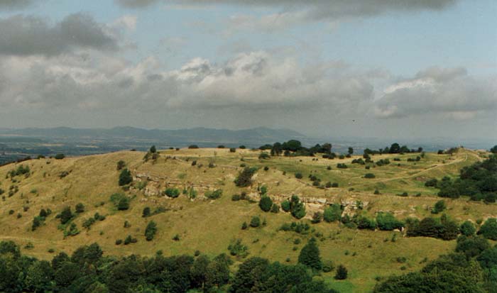
Crickley Hill General submitted by vicky on 10th Sep 2002. Crickley Hill in Gloucestershire - Neolithic enclosure and Iron Age Hillfort.
(View photo, vote or add a comment)
Log Text: Walking the Cotswold Way north around Crickley Hill, and the first thing seen is a large bank across the headland. After the turn at the point, progressing back along the northern side and it is seen that there were once substantial defences, and many modern day concrete markers show the points where the huts etc were found. A series of notice boards give a full history of the place and there is an information centre, which I did not have time to look round today. Somewhere to come back to on another time.
Fantastic views all around, the Malvern Hills to the north, the Forest of Dean and Black Mountains to the west, and all along the Cotswold edge in both directions.
Crippet's Barrow
Date Added: 11th Jun 2021
Site Type: Chambered Tomb
Country: England (Gloucestershire)
Visited: Yes on 8th Jun 2021. My rating: Condition 3 Ambience 3 Access 3
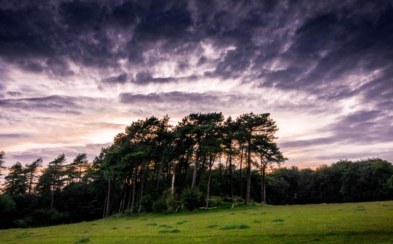
Crippet's Barrow submitted by Humbucker on 17th Mar 2018. Crippet's / Shurdington Long Barrow from the south east. I visited late afternoon in the Autumn of 2017. I had heard of very inquisitive horses in the field, but it was empty when I visited.
(View photo, vote or add a comment)
Log Text: Walking the Cotswold Way north from Crickley Hill, and I forgot to keep a look out for Crippet's Long Barrow, but at this point the footpath and separate bridleway are well fenced in, so I wouldn't have been able to get to the edge of the woodlands at the top of the hill to have a look anyway. I later got a long distance view from near the radio masts and reservoir entrance, just about making out the large barrow in its tree covered setting.
Croazou chapel
Trip No.203 Entry No.524 Date Added: 28th May 2020
Site Type: Ancient Cross
Country: France (Bretagne:Finistère (29))
Visited: Yes on 21st Jun 2005. My rating: Condition 3 Ambience 3 Access 5
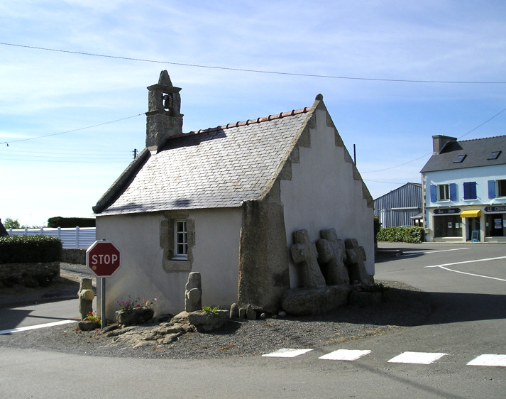
Croazou chapel submitted by thecaptain on 3rd Jul 2005. The little chapel at Croazou in its modern road junction.
The cornerstone is an Iron Age Stele, and the three medieval crosses by the back wall are sitting on a fallen menhir.
How much more continuity of somewhere being a sacred place can you get.
(View photo, vote or add a comment)
Log Text: This is an odd little place where many thousands of years of ritual and worship can all be seen together. In the middle of a fairly busy road junction is built a little chapel which is said to be the smallest in Finistère. This chapel has been built onto a stèle with it still standing there at one of the back corners about 2 metres tall.
Outside the back wall are three medieval crosses positioned on top of a fallen menhir supposedly in all being in their original positions. Around the outside of the chapel is also a fairly recent collection of other crosses from the region which includes one intriguing cross which has been mounted on the top portion of what was obviously once a lovely iron age stele with wonderful shaping and patterns carved into it.
Trouble is while I was there it must have been going home time and the junction was very busy and stopping and getting pictures was very difficult having enough time to stand in the road and get a photo without getting run down.
Croazou chapel
Trip No.214 Entry No.6 Date Added: 28th May 2020
Site Type: Ancient Cross
Country: France (Bretagne:Finistère (29))
Visited: Yes on 16th Apr 2014. My rating: Condition 4 Ambience 3 Access 5
Croazou chapel menhir submitted by regina on 1st Oct 2019. Site in Bretagne:Finistère (29) France
(View photo, vote or add a comment)
Log Text: Driving away from Men-Marz through the maze like country lanes and after about 10 mins I thought I was completely lost, and then all of a sudden I arrived at the road junction with this little chapel in the middle of it. Aha, fabulous, I hadn't intended coming here as there was no time, but now I'm here, better have a quick look. It's probably best not to just abandon your car in the middle of the junction, but I thought it would be OK for a few minutes!
This odd little chapel is said to be the smallest in Finistère, and is a place where many thousands of years of ritual and worship can all be seen together. The chapel has been built onto a stèle or menhir with it still standing there at one of the back corners about 2 metres tall. Outside the back wall are three medieval crosses positioned on top of a fallen menhir supposedly in all being in their original positions. Around the outside of the chapel is also a fairly recent collection of other crosses from the region which includes one intriguing cross which has been mounted on the top portion of what was obviously once a lovely iron age stele with wonderful shaping and patterns carved into it.
The door to the chapel was unlocked, so I had a quick butchers inside, but it was slightly disappointing in that the corner menhir could not be seen from inside.
