

<< Our Photo Pages >> Créac’h-ar-Vrenn - Passage Grave in France in Bretagne:Finistère (29)
Submitted by TheCaptain on Tuesday, 28 December 2004 Page Views: 5094
Neolithic and Bronze AgeSite Name: Créac’h-ar-Vrenn Alternative Name: Kougn An Dre, Couing Andre, An-Ti-Roc’h, Allée couverte de Coulnandré, Gouénic an DreffCountry: France Département: Bretagne:Finistère (29) Type: Passage Grave
Nearest Town: St-Pol-de-Léon Nearest Village: Plouescat
Latitude: 48.656833N Longitude: 4.15751W
Condition:
| 5 | Perfect |
| 4 | Almost Perfect |
| 3 | Reasonable but with some damage |
| 2 | Ruined but still recognisable as an ancient site |
| 1 | Pretty much destroyed, possibly visible as crop marks |
| 0 | No data. |
| -1 | Completely destroyed |
| 5 | Superb |
| 4 | Good |
| 3 | Ordinary |
| 2 | Not Good |
| 1 | Awful |
| 0 | No data. |
| 5 | Can be driven to, probably with disabled access |
| 4 | Short walk on a footpath |
| 3 | Requiring a bit more of a walk |
| 2 | A long walk |
| 1 | In the middle of nowhere, a nightmare to find |
| 0 | No data. |
| 5 | co-ordinates taken by GPS or official recorded co-ordinates |
| 4 | co-ordinates scaled from a detailed map |
| 3 | co-ordinates scaled from a bad map |
| 2 | co-ordinates of the nearest village |
| 1 | co-ordinates of the nearest town |
| 0 | no data |
Internal Links:
External Links:
I have visited· I would like to visit
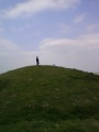
TheCaptain visited on 22nd Jun 2005 - their rating: Cond: 3 Amb: 3 Access: 4 I am not 100% sure that I found this. What I possibly found is just some natural rocks. I looked all over the place and asked a couple of people, who both pointed me in the other direction away from their house towards the others. Despite signposts to it down the same lane as the menhir, there was no further evidence for it down there, but the new house being built is probably where the path went.
What I did find, behind the house at the top of the hill beside the water tower, was two rounded looking granite blocks, but it is possible that they have been placed there. With all the fences and undergrowth it was impossible to see if the stones were resting on any kind of supports, but these stones are certainly in the right position for where it is marked on the map.
Martin_L have visited here
")
I am not 100% sure that I found this. What I possibly found is just some natural rocks. I looked all over the place and asked a couple of people, who both pointed me in the other direction away from their house towards the others.
Despite signposts to it down the same lane as the menhir, there was no further evidence for it down there, but the new house being built is probably where the old path went.
What I did find, behind the house at the top of the hill beside the water tower, was two rounded looking granite blocks, but it is possible that they have been placed there. With all the fences and undergrowth it was impossible to see if the stones were resting on any kind of supports, but these stones are certainly in the right position for where it is marked on the map.
Note: Allée couverte de Créach-ar-Vrenn
You may be viewing yesterday's version of this page. To see the most up to date information please register for a free account.
")
")
")
")
Do not use the above information on other web sites or publications without permission of the contributor.
Nearby Images from Flickr


The above images may not be of the site on this page, but were taken nearby. They are loaded from Flickr so please click on them for image credits.
Click here to see more info for this site
Nearby sites
Click here to view sites on an interactive map of the areaKey: Red: member's photo, Blue: 3rd party photo, Yellow: other image, Green: no photo - please go there and take one, Grey: site destroyed
Download sites to:
KML (Google Earth)
GPX (GPS waypoints)
CSV (Garmin/Navman)
CSV (Excel)
To unlock full downloads you need to sign up as a Contributory Member. Otherwise downloads are limited to 50 sites.
Turn off the page maps and other distractions
Nearby sites listing. In the following links * = Image available
126m WNW 300° Couinandré Menhir* Standing Stone (Menhir)
1.3km ENE 68° Kerider stèle* Standing Stone (Menhir)
2.0km N 5° Menhir de Kergallec Standing Stone (Menhir)
2.5km N 349° Menhir d'Irvit* Standing Stone (Menhir)
3.3km W 280° Prat Meur menhir* Standing Stone (Menhir)
3.8km NW 320° Grand menhir de Saint-Eden* Standing Stone (Menhir)
3.8km NNW 330° Menhir de Kergoarat* Standing Stone (Menhir)
3.9km WNW 288° Porz Ar Stréat menhir* Standing Stone (Menhir)
4.3km W 270° Guinivrit* Passage Grave
4.7km WSW 256° Menhir de Kernic Standing Stone (Menhir)
5.3km WSW 247° Calvaire de Menez-ar-Plour Standing Stone (Menhir)
5.7km WSW 257° Stèle dite Ar Groaz Standing Stone (Menhir)
5.8km WSW 253° Menhir de Brétouaré 1 Standing Stone (Menhir)
5.9km WSW 249° Menhir de Brétouaré 2 Standing Stone (Menhir)
5.9km WSW 250° Dolmen de Brétouaré Burial Chamber or Dolmen
6.0km SW 222° Parc Ar ouest menhir Standing Stone (Menhir)
6.0km SW 222° Parc Ar est menhir Standing Stone (Menhir)
6.0km NE 53° Affleurement à Cupules de Creach al Lia Rock Art
6.1km ENE 74° Allée couverte de Lia Passage Grave
6.2km SSW 204° Landeguiarc'h menhir Standing Stone (Menhir)
6.3km E 88° Menhir de Keringar* Standing Stone (Menhir)
7.6km ENE 65° Dolmen de Tévenn Burial Chamber or Dolmen
10.6km WSW 248° Créac'h Gallic* Passage Grave
11.2km ENE 65° Dalle à Cupules de Mean Diante Rock Art
11.4km W 269° Diévet Dolmen* Burial Chamber or Dolmen
View more nearby sites and additional images


 We would like to know more about this location. Please feel free to add a brief description and any relevant information in your own language.
 Wir möchten mehr über diese Stätte erfahren. Bitte zögern Sie nicht, eine kurze Beschreibung und relevante Informationen in Deutsch hinzuzufügen.
 Nous aimerions en savoir encore un peu sur les lieux. S'il vous plaît n'hesitez pas à ajouter une courte description et tous les renseignements pertinents dans votre propre langue.
 Quisieramos informarnos un poco más de las lugares. No dude en añadir una breve descripción y otros datos relevantes en su propio idioma.