Contributory members are able to log private notes and comments about each site
Sites TheCaptain has logged. View this log as a table or view the most recent logs from everyone
East Moor stone C
Date Added: 29th Oct 2019
Site Type: Standing Stone (Menhir)
Country: England (Cornwall)
Visited: Yes on 6th Dec 2010
East Moor stone C submitted by TheCaptain on 6th Dec 2010. About 50 metres to the southeast of the round cairn can be seen a stone standing proud of the moor, so I went for a look. It is clearly an edge set stone positioned here, about 2.5 feet tall and wide, a definite stander similar to the one to the west of the cairn.
(View photo, vote or add a comment)
Log Text: None
East Moor stone B
Date Added: 29th Oct 2019
Site Type: Standing Stone (Menhir)
Country: England (Cornwall)
Visited: Yes on 6th Dec 2010
East Moor stone B submitted by TheCaptain on 6th Dec 2010. Less than 50 metres to the west of the round cairn can be seen a stone standing proud of the moor, so I went for a look.
It is clearly an edge set stone positioned here, 2 feet tall, 3 feet wide and having lost its top.
(View photo, vote or add a comment)
Log Text: None
East Moor Row blocking stone
Date Added: 18th Sep 2010
Site Type: Standing Stone (Menhir)
Country: England (Cornwall)
Visited: Yes on 23rd Jul 2010
East Moor Row blocking stone submitted by TheCaptain on 23rd Jul 2010. East Moor Stone Row blocking stone is directly in line with the stone row, and exactly at right angles across where the row would be, right on the top of the hill.
VIewed here looking southwest, as if continuing along the row.
(View photo, vote or add a comment)
Log Text: None
East Moor ring cairn
Date Added: 29th Oct 2019
Site Type: Ring Cairn
Country: England (Cornwall)
Visited: Yes on 5th Dec 2010
East Moor ring cairn submitted by TheCaptain on 5th Dec 2010. The ring cairn centrally on the top of the hill in the middle of East Moor is a splendid example, about 15 metres in diameter. It has a rubble bank about 1 metre wide surrounding a nicely flattened centre.
Pictures cannot do this ring cairn any justice.
View looking southeast towards Trewortha Tor.
(View photo, vote or add a comment)
Log Text: None
East Moor menhir
Date Added: 18th Sep 2010
Site Type: Standing Stone (Menhir)
Country: England (Cornwall)
Visited: Yes on 22nd Jul 2010
East Moor menhir submitted by TheCaptain on 22nd Jul 2010. This large prostrate menhir is 2.5 to 3 metres in length, of quite slender section.
Viewed here looking northwestish.
(View photo, vote or add a comment)
Log Text: None
East Moor cairn
Date Added: 29th Oct 2019
Site Type: Round Cairn
Country: England (Cornwall)
Visited: Yes on 5th Dec 2010
East Moor cairn submitted by TheCaptain on 5th Dec 2010. This is a nice large cairn about 14 or 15 metres in diameter, which has several large slab stones surrounding it, and what seems to be the robbed out remains of a chamber in the centre.
(View photo, vote or add a comment)
Log Text: None
East Kennett longbarrow
Date Added: 2nd Oct 2020
Site Type: Long Barrow
Country: England (Wiltshire)
Visited: Saw from a distance on 25th Sep 2020
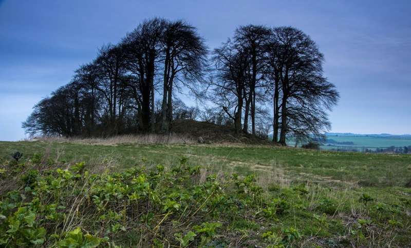
East Kennett longbarrow submitted by Humbucker on 21st Nov 2017. East Kennet Longbarrow. Without the leaves on the trees you can appreciate just how big this longbarrow is!
(View photo, vote or add a comment)
Log Text: I should have gone a bit further up the road from East Kennet to get a view of the long barrow on the hillside. However, good views over to East Kennet longbarrow from the hills near West Kennet barrow.
East Kennett longbarrow
Date Added: 8th Oct 2020
Site Type: Long Barrow
Country: England (Wiltshire)
Visited: Saw from a distance on 4th Oct 1998

East Kennett longbarrow submitted by Humbucker on 21st Nov 2017. East Kennet Longbarrow. Without the leaves on the trees you can appreciate just how big this longbarrow is!
(View photo, vote or add a comment)
Log Text: Visit lots of ancient sites on a long off road cycle tour from Avebury to Windmill Hill, along the Wansdyke and back up Kennet Avenue
East Kennett garden feature
Date Added: 8th Oct 2020
Site Type: Modern Stone Circle etc
Country: England (Wiltshire)
Visited: Yes on 25th Jul 2002. My rating: Condition 3 Ambience 3 Access 4
East Kennett garden feature submitted by JJ on 24th Dec 2005. A view of the East Kennet avenue and circle. These must be modern stones, does anyone have more information?
(View photo, vote or add a comment)
Log Text: None
East Kennett garden feature
Date Added: 8th Oct 2020
Site Type: Modern Stone Circle etc
Country: England (Wiltshire)
Visited: Yes on 4th Oct 1998
East Kennett garden feature submitted by JJ on 24th Dec 2005. A view of the East Kennet avenue and circle. These must be modern stones, does anyone have more information?
(View photo, vote or add a comment)
Log Text: Visit lots of ancient sites on a long off road cycle tour from Avebury to Windmill Hill, along the Wansdyke and back up Kennet Avenue
Dyrham Camp
Date Added: 17th Oct 2020
Site Type: Hillfort
Country: England (Gloucestershire)
Visited: Yes on 9th Sep 2007
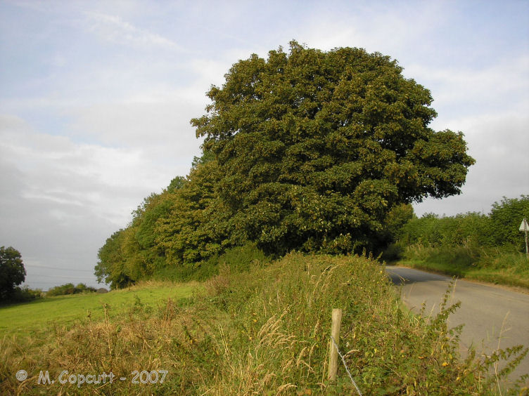
Dyrham Camp submitted by thecaptain on 28th Aug 2008. The western "point" of Hinton Hillfort, where it is cut into two by the little road up the hillside from the village of Hinton below.
(View photo, vote or add a comment)
Log Text: Dyrham Camp, otherwise known as Hinton Hillfort, is not so much a hillfort, but more a promontary fort, on a southwest facing spur of the Cotswold Hills north of Bath. Basically triangular in shape, it is cut into two by the little road up the hillside from the village of Hinton below. The northern part is mostly in woodland, and seems to be used as a rubbish dump these days. The hill edge has been shaped, and in places the bank and ditch is in fine condition, perhaps kept in shape in more recent times for drainage. The southern half of the fort is open pasture with a public footpath running through, and the steep southern slopes are sort of terraced, with several almost cliff like ramparts, below which are quite spectacular remains of ancient field systems. The eastern edge of the fort, where the land is flat on top of the Cotswold plateau, has a large ditch and bank in place across the headland. The ditch is about 10 metres wide and 2 metres deep, with a bank up to 4 metres high on the inside, which even these days is a fairly good barrier to entry.
Dyrham Camp
Date Added: 17th Oct 2020
Site Type: Hillfort
Country: England (Gloucestershire)
Visited: Yes on 9th Oct 2020
Dyrham Camp submitted by Thorgrim on 22nd Aug 2003. Dyrham Camp, otherwise known as Hinton Hillfort, is best seen from high land in Dyrham Park (National Trust) Dating from the Iron Age, it was the likely site of the Battle of Dyrham in 577 AD when the Anglo-Saxon Chronicle tells us that the invading Saxons under "Cuthwine and Ceawlin fought against the Britons and slew three kings, Coinmail, Condidan and Farimail at the place which is called Dyrham; and they captured three cities, Gloucester, Cirencester and Bath"
(View photo, vote or add a comment)
Log Text: Walking a loop on the Cotswold Way around Dyrham and Tormarton, see Hinton Hillfort from the southern side in the fading autumn sunlight.
Dyce Stones
Date Added: 29th Oct 2019
Site Type: Standing Stones
Country: Scotland (Aberdeenshire)
Visited: Yes on 11th Feb 2019
Dyce Stones submitted by TheCaptain on 11th Feb 2019. Pair of stones standing in a grassy area between a major road intersection and a petrol station near to the entrance of Aberdeen (Dyce) International Airport.
I don't know whether the stones are ancient and have been moved from elsewhere during the Airport and surrounding business park development.
(View photo, vote or add a comment)
Log Text: None
Dunstanburgh Castle
Date Added: 8th May 2023
Site Type: Promontory Fort / Cliff Castle
Country: England (Northumberland)
Visited: Yes on 25th Sep 2022. My rating: Condition 3 Ambience 4 Access 3
Dunstanburgh Castle submitted by SolarMegalith on 21st Aug 2017. A general view of the promontory with Dunstanburgh Castle and site of an Iron Age settlement (photo taken on July 2017).
(View photo, vote or add a comment)
Log Text: Day up to Dunstanburgh castle. Park at Craster, buy sandwiches then walk along the coast northwards to the castle. Excellent.
Dunnabridge Pound
Date Added: 27th Sep 2020
Site Type: Ancient Village or Settlement
Country: England (Devon)
Visited: Yes on 18th Sep 2020. My rating: Condition 4 Ambience 3 Access 5
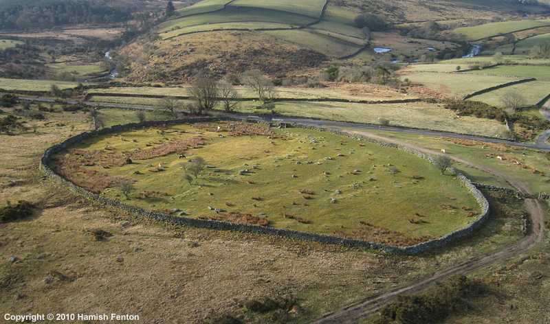
Dunnabridge Pound submitted by h_fenton on 27th Apr 2010. Dunnabridge Pound from the air.
Kite Aerial Photograph
7 April 2010 @ 9am
(View photo, vote or add a comment)
Log Text: Now I can head back down the hillside on a decent track to Dunnabridge, passing what are probably interesting remains of Brimpts Mine, which on another less tired time I would go and explore! Once down and before walking up the road to the car park, I decide for a quick look in Dunnabridge Pound with the Judge's Chair, which once more is in dark shadow.
I get back to the car at 5:15 after walking 14.3 km and ascending 337 m of vertical, now slightly regretting cutting off the northernmost part of the walk to Postbridge, as it is so much easier on the made tracks. A damn good day out, my back and legs have been working well. Now for a pint at the Warren House Inn where I sit taking in the beautiful views over to Grimspound. Thats a walk for another day.
Dunnabridge Pound
Date Added: 2nd Oct 2020
Site Type: Ancient Village or Settlement
Country: England (Devon)
Visited: Yes on 11th Apr 2019. My rating: Condition 4 Ambience 3 Access 5

Dunnabridge Pound submitted by h_fenton on 27th Apr 2010. Dunnabridge Pound from the air.
Kite Aerial Photograph
7 April 2010 @ 9am
(View photo, vote or add a comment)
Log Text: The Judges Chair in deep shadow, so no good for photos, but a nice little sit down
Dry Tree Menhir
Date Added: 2nd Aug 2022
Site Type: Standing Stone (Menhir)
Country: England (Cornwall)
Visited: Yes on 16th Jun 2022. My rating: Condition 4 Ambience 4 Access 4
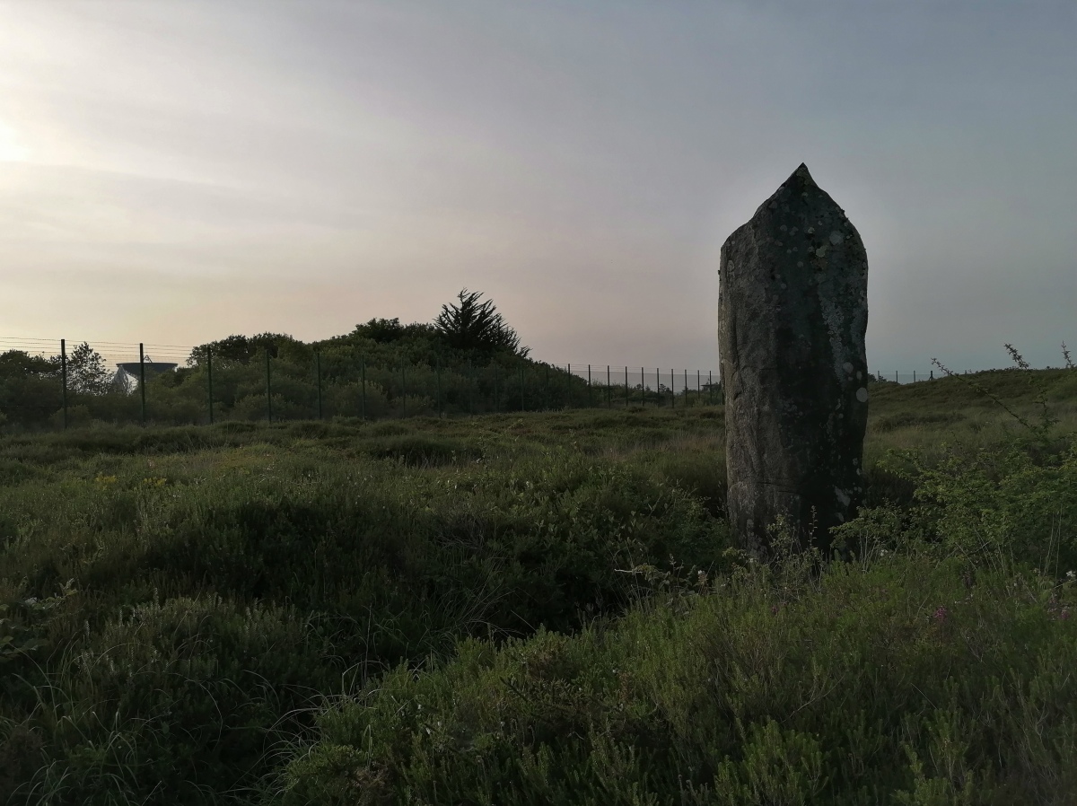
Dry Tree Menhir submitted by TheCaptain on 2nd Aug 2022. A glorious mix of ancient standing stone, juxtaposed beside all the hiTech tracking station dishes, especially as the sun was setting behind hazy clouds.
(View photo, vote or add a comment)
Log Text: After an afternoon visiting Kynance Cove and Lizard Point, then dinner at the Witchball, it is getting late, and I want to go find the Dry Tree menhir beside Goonhilly Downs Earth Station. Park in the nature reserve car park and a lovely walk all around, to find the glorious mix of ancient standing stone and tumuli, juxtaposed beside all the hiTech tracking station dishes. Lovely in the setting sun.
Dry Lake North Settlement
Date Added: 18th Sep 2010
Site Type: Ancient Village or Settlement
Country: England (Devon)
Visited: Yes on 29th Jul 2006
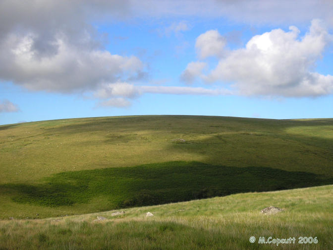
Dry Lake North Settlement submitted by thecaptain on 29th Jul 2006. Fairly well preserved ancient settlement on the eastern flanks of the Erme valley, consisting of several large walled enclosures, each containing several huts.
(View photo, vote or add a comment)
Log Text: None
Druids Circle (Penmaenmawr)
Date Added: 4th Nov 2023
Site Type: Stone Circle
Country: Wales (Conwy)
Visited: Yes on 13th Sep 2023. My rating: Condition 5 Ambience 4 Access 2
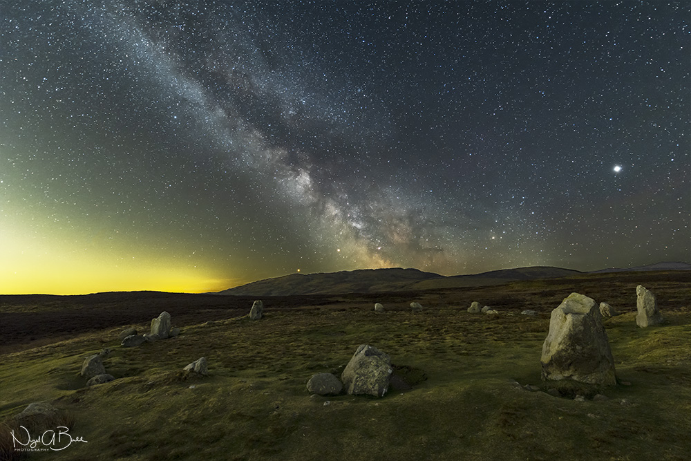
Druids Circle (Penmaenmawr) submitted by nigeynoo on 24th Apr 2018. The magical Druids Circle taken at night with the Milky Way, Mars, Saturn and Jupiter
(View photo, vote or add a comment)
Log Text: From circle 275 the stones of the Druids Circle can be seen up on the hill against the skyline. I make straight for it, but this is probably not the best way as it takes me through a little valley with lots of boggy area to get through. The site is positioned on a flattened platform area, with an embanked circle of stones about 35 metres diameter. Several of the stones are large and standing upright, many much smaller and some are flat to the ground. The position up here is gorgeous with the views out and over the sea with the Great Orme to the east, and Anglesey to the west. There are a couple here taking it all in, with the lady sat sketching the circle. I was intending having my lunch here, but I move on to the next site for that, so we do not disturb each other.
Druid Stoke
Date Added: 16th Aug 2019
Site Type: Chambered Tomb
Country: England (Gloucestershire)
Visited: Yes on 15th Aug 2019. My rating: Condition 2 Ambience 2 Access 5
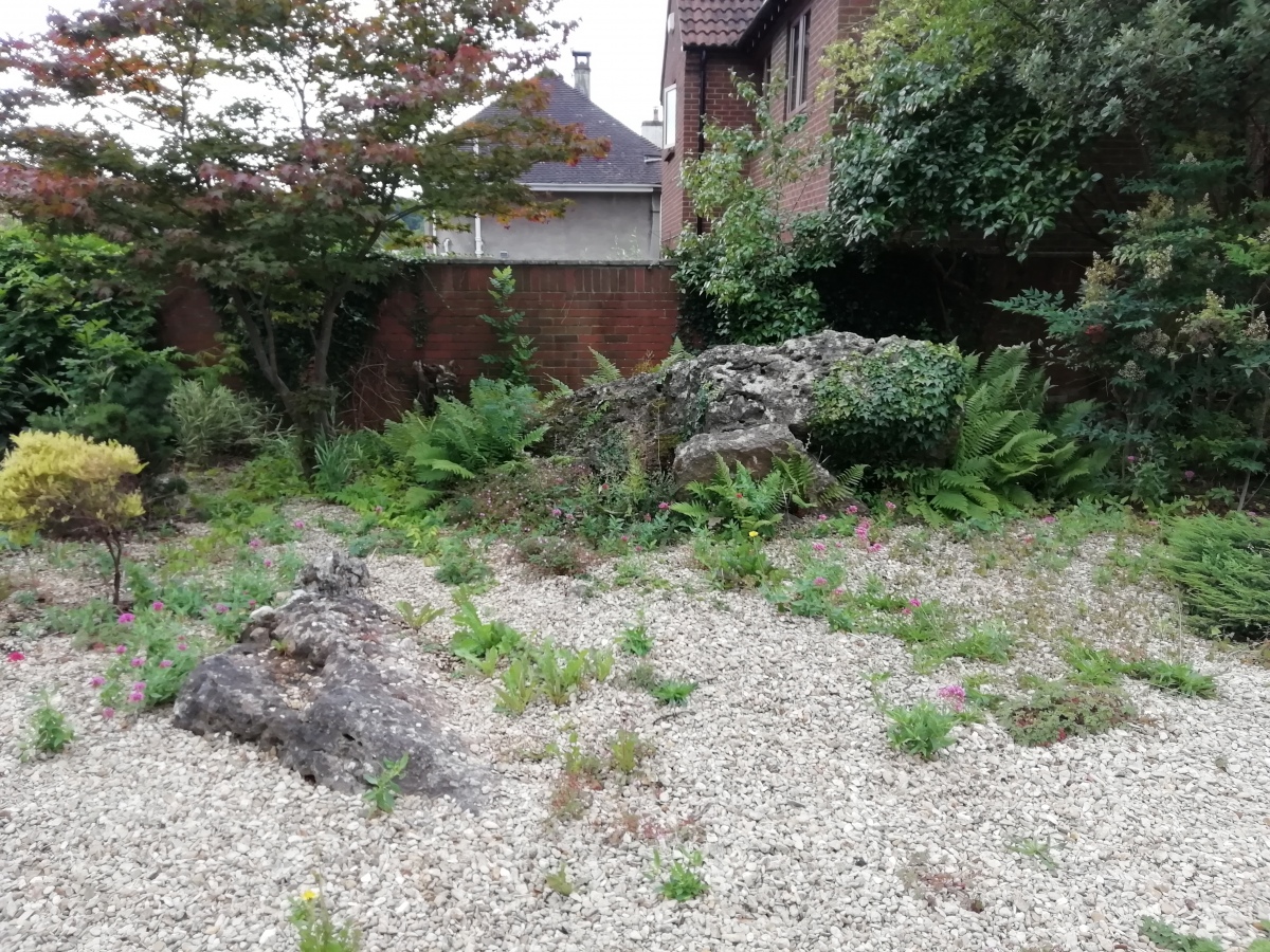
Druid Stoke submitted by TheCaptain on 16th Aug 2019. A few large stones remain in the parking area outside a large house near the top of Druid Hill, in the leafy suburb od Stoke Bishop, north of Bristol. The stones can be seen from the road through the gateway. (August 2019)
(View photo, vote or add a comment)
Log Text: How on Earth can I never have been to visit this before, as 43 years ago I lived only half a mile away! So, on a sunny day, after a visit to the expensive dentist, I stopped by for a look. A few large stones remain in the parking area outside a large house near the top of Druid Hill, in the leafy suburb od Stoke Bishop, north of Bristol. The stones can be seen from the road through the gateway.
