Contributory members are able to log private notes and comments about each site
Sites TheCaptain has logged. View this log as a table or view the most recent logs from everyone
Furzehill Common Standing Stone
Date Added: 18th Sep 2010
Site Type: Standing Stone (Menhir)
Country: England (Devon)
Visited: Yes on 14th Sep 2009

Furzehill Common Standing Stone submitted by thecaptain on 14th Sep 2009. The recently broken Furzehill Common standing stone, viewed here looking southwest over the common.
(View photo, vote or add a comment)
Log Text: None
The Long Stone (Minions)
Date Added: 8th Sep 2025
Site Type: Standing Stone (Menhir)
Country: England (Cornwall)
Visited: Yes on 20th Sep 2009. My rating: Condition 5 Ambience 4 Access 5
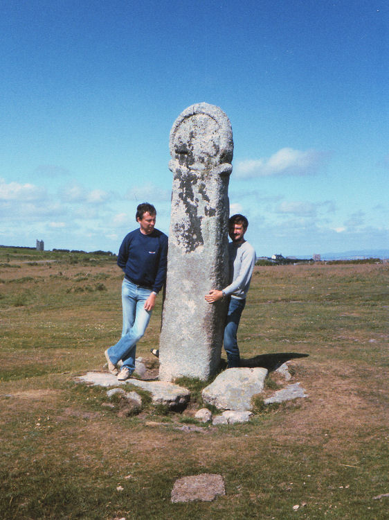
The Long Stone (Minions) submitted by thecaptain on 31st Aug 2008. Long Tom, near Minions.
Picture from about 1980.
(View photo, vote or add a comment)
Log Text: What a fantastic stone this is. As for the Hurlers, it is decades since I was last here, and it is bigger and better shaped than I remember. It is 2.6 metres tall and very slender, and covered in some beautiful lichens. With the sun dropping down in the sky, the golden light on this stone is superb. Only problem is the vehicle tracks all around it, having churned up the grass of the moor. What is up with these people who seem to feel the need to mess everything up?
Craddock Moor circle
Date Added: 27th Aug 2025
Site Type: Stone Circle
Country: England (Cornwall)
Visited: Yes on 20th Sep 2009. My rating: Condition 3 Ambience 4 Access 3
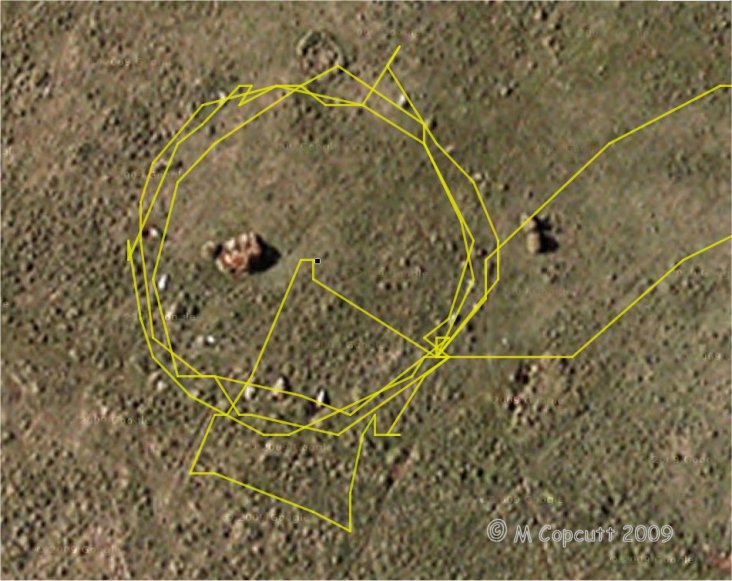
Craddock Moor circle submitted by thecaptain on 22nd Sep 2009. gps track plot of my wanderings round Craddock Moor stone circle on Sunday. Many of the stones can be seen in the picture.
I use an ageing Garmin etrex Venture pocket reciever, and the track is plotted out using GPSVisualizer, with only a few minutes fiddling.
I find it amazing the results that can now be obtained for things like this, using cheap, readily available technology, in a pocketsized device.
(View photo, vote or add a comment)
Log Text: After turning off the track near to the cairn, and heading out over the open moor, I found the circle easily, having headed straight to it from judging things looking at the map, and not using the GPS. I counted about 17 or 18 stones plus gaps on my first time round, but perhaps 19 or 20 next time round including lumps under tufts of grass. The circle is about 42 paces in diameter, with about 5 paces between each stone. When here, in September at the end of the summer, the grass and suchlike was very long, making most of the stones difficult to spot, so I first walked around the outside checking out what I could find. Then I walked around again taking photos, hence some excursions from the circle. I then went to the middle to survey the scene as a whole before looking for somewhere to sit and eat my pasty for lunch, which I would have liked to be the middle of the circle, but there was only long grass there, so a convenient and comfortable looking stone at the southeast did the job. I looked at my gps and was amazed at the nice circle on the screen, so thought I would "draw" another circle on it before I left !
Craddock Moor platform cairn
Date Added: 25th Aug 2025
Site Type: Cairn
Country: England (Cornwall)
Visited: Yes on 20th Sep 2009. My rating: Condition 3 Ambience 4 Access 3

Craddock Moor platform cairn submitted by thecaptain on 1st Oct 2009. View northeast over Craddock Moor platform cairn, and right across the middle of Bodmin Moor.
Cornwall's very own mountain Brown Willy is in the distance.
(View photo, vote or add a comment)
Log Text: Following the track out towards Golddiggings quarry, there is a cairn marked at about the top of the local moorland, about where I need to head off southwest to find the stone circle. The cairn is clear to see, and is quite a big but low flat circle, probably up to a metre high above the surrounding moor. Much of it is covered by ferns, and this morning is surrounded by guard cows, some with vicious looking horns, which kept me away on the way out. The views from here are superb, with Brown Willy to be seen off to the northwest, and Sharptor and Stowes Pound very clear to the northeast. It is beautiful out here on the open moor. Turns out this is a circular platform cairn with peripheral berm, 24m in diameter for the cairn and up to 31m in diameter with its berm. English Heritage Scheduled Monument 15056 http://www.magic.gov.uk/rsm/15056.pdf
Rillaton Barrow
Date Added: 8th Sep 2025
Site Type: Round Barrow(s)
Country: England (Cornwall)
Visited: Yes on 20th Sep 2009. My rating: Condition 4 Ambience 3 Access 4
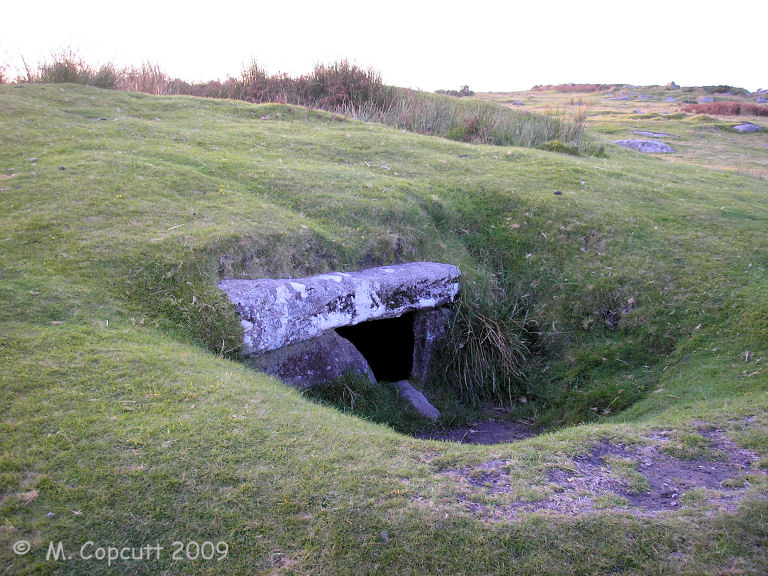
Rillaton Barrow submitted by thecaptain on 24th Oct 2009. The chamber is halfway up the eastern side, in a separate depression of its own, and cannot be seen as you pass, so I suspect most people who pass this way do not realise it is there.
(View photo, vote or add a comment)
Log Text: The largest round barrow on Bodmin Moor, about 35 metres in diameter and almost 3 metres high. It is again bigger than I remember it, and at first I can’t find the chamber from where the Rillaton Gold Cup was found. After I have walked all around the barrow, I realise that the chamber is halfway up the eastern side, in a separate depression of its own, so I suspect most people who pass this way do not realise it is there. The top slab is clearly seen sitting on the side slabs, with a gap at one end through which the inside can be seen. Again the inside looks bigger than I remember, and it is very well lined with nicely smoothed and squared slabs. Some good stonework went into making this. I stick the camera inside to fire off a few photos. The top of the mound has been well dug into, and even after all this dry weather, there is a pond in it. It makes me wonder whether there are any more chambers in the mound just waiting to be found, and if there is just the single chamber, why is it somehow randomly placed near but not at one of the edges?
Craddock Moor stone row
Date Added: 18th Sep 2010
Site Type: Stone Row / Alignment
Country: England (Cornwall)
Visited: Yes on 22nd Sep 2009

Craddock Moor stone row submitted by thecaptain on 22nd Sep 2009. gps track plot of my wanderings round Craddock Moor, along the embanked avenue and then the stone row on Sunday.
I use an ageing Garmin etrex Venture pocket reciever, and the track is plotted out using GPSVisualizer, with only a few minutes fiddling.
I find it amazing the results that can now be obtained for things like this, using cheap, readily available technology, in a pocketsized device.
(View photo, vote or add a comment)
Log Text: None
Bearah Common Long Cairn
Date Added: 18th Sep 2010
Site Type: Chambered Cairn
Country: England (Cornwall)
Visited: Yes on 26th Sep 2009
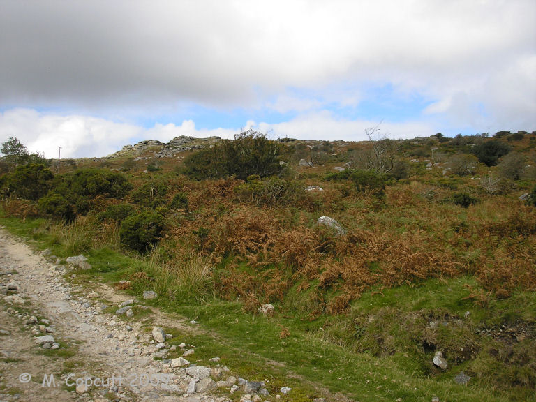
Bearah Common Long Cairn submitted by thecaptain on 26th Sep 2009. Although the long cairn is right beside the trackway, it is difficult to see as you approach unless you are really looking !
(View photo, vote or add a comment)
Log Text: None
Craddock Moor Stone Setting
Date Added: 18th Sep 2010
Site Type: Standing Stones
Country: England (Cornwall)
Visited: Yes on 30th Sep 2009
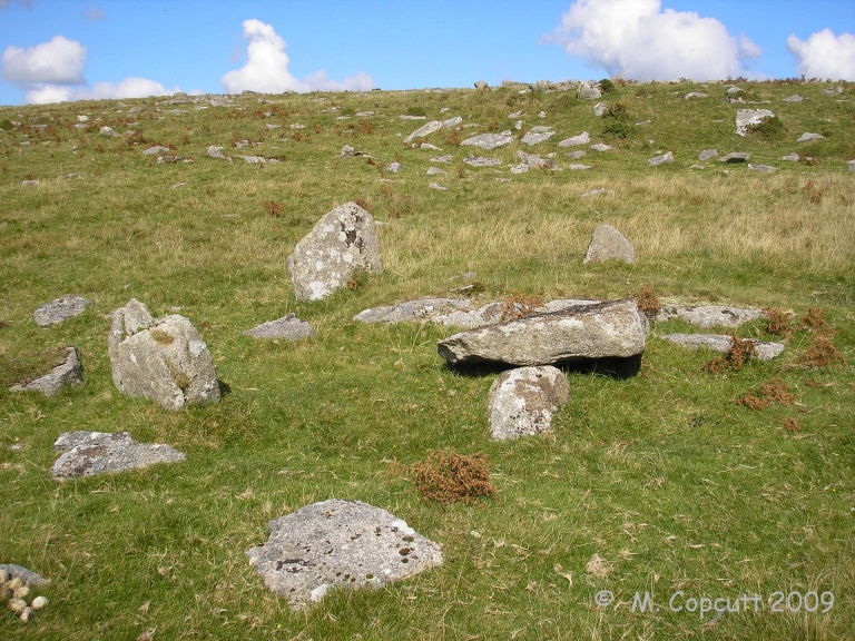
Craddock Moor Stone Setting submitted by thecaptain on 30th Sep 2009. On the rocky slopes to the southwest of Goldiggings Quarry, a small stone setting is to be found. The obvious stones which are first seen are three or four standing stones about half a metre tall making a sort of circle, with a slab lying on top of a further stone within it.
(View photo, vote or add a comment)
Log Text: None
Stowe's Pound
Date Added: 18th Sep 2010
Site Type: Ancient Village or Settlement
Country: England (Cornwall)
Visited: Yes on 2nd Oct 2009

Stowe's Pound submitted by thecaptain on 2nd Oct 2009. Stowe's Pound, with its two neolithic hilltop enclosures, plus settlement with its many hut circles and field systems.
Seen here looking east from Craddock Moor.
(View photo, vote or add a comment)
Log Text: None
Craddock Moor embanked avenue
Date Added: 18th Sep 2010
Site Type: Misc. Earthwork
Country: England (Cornwall)
Visited: Yes on 7th Oct 2009
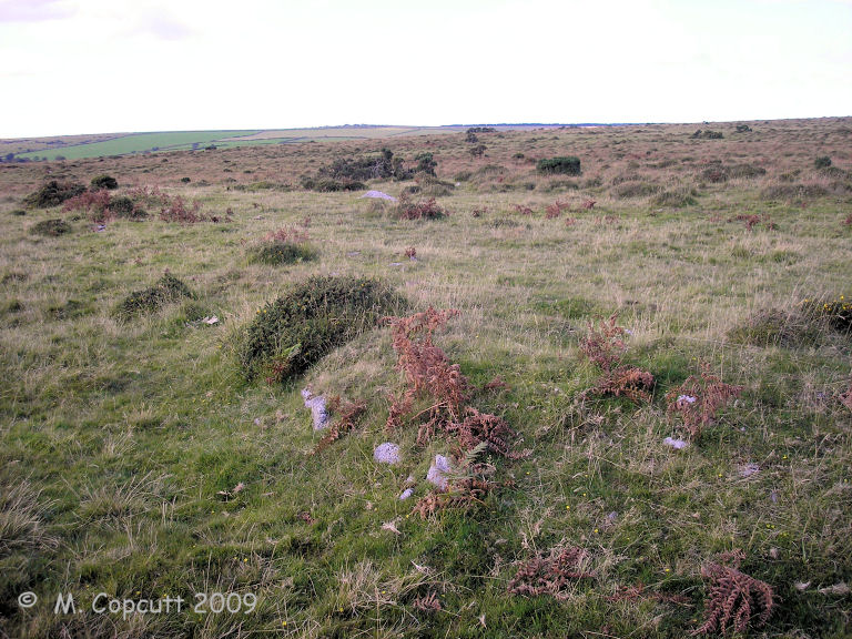
Craddock Moor embanked avenue submitted by thecaptain on 7th Oct 2009. The banks are still about half a metre to a metre in height, and in places seem to have got some stone slabs along the inner edges, perhaps once making a sort of kerb.
(View photo, vote or add a comment)
Log Text: None
Tregarrick Tor hillfort
Date Added: 18th Sep 2010
Site Type: Hillfort
Country: England (Cornwall)
Visited: Yes on 21st Oct 2009

Tregarrick Tor hillfort submitted by thecaptain on 21st Oct 2009. View northeast from Tregarrick Tor, across Craddock Moor to Stowe's Pound.
Many of the huts etc of the enclosed settlement can be seen in the foreground.
(View photo, vote or add a comment)
Log Text: None
Tregarrick Tor cairn
Date Added: 18th Sep 2010
Site Type: Chambered Cairn
Country: England (Cornwall)
Visited: Yes on 21st Oct 2009

Tregarrick Tor cairn submitted by thecaptain on 21st Oct 2009. The southern outcrop of Tregarrick Tor, with its "tor cairn" built up to it on the right hand slopes, and also the strange stone setting type arrangement in the foreground.
Is it part of a cairn internal structure or perhaps a separate stone setting of some kind.
(View photo, vote or add a comment)
Log Text: None
Minions Platform Round Barrow
Date Added: 18th Sep 2010
Site Type: Cairn
Country: England (Cornwall)
Visited: Yes on 22nd Oct 2009

Minions Platform Round Barrow submitted by thecaptain on 22nd Oct 2009. The platform cairn marked on OS Maps as "Minions Mound".
In reality it is not the round barrow of that name which gave its name to the village, which was previously known as "Cheesewring Railway".
(View photo, vote or add a comment)
Log Text: None
menhir Garde Guerin
Date Added: 18th Sep 2010
Site Type: Standing Stone (Menhir)
Country: France (Bretagne:Ille-et-Vilaine (35))
Visited: Yes on 25th Oct 2009
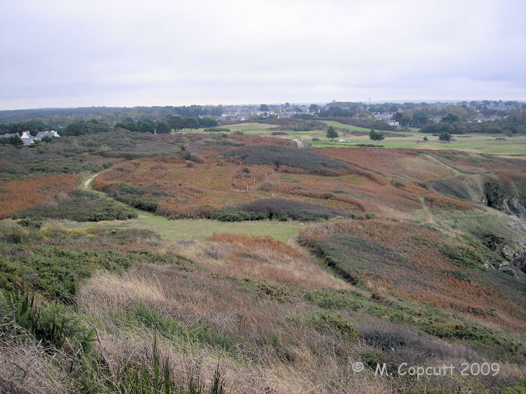
menhir Garde Guerin submitted by thecaptain on 25th Oct 2009. Looking inland along the western side of the Pointe de la Garde Guérin, over where the menhir supposedly is.
(View photo, vote or add a comment)
Log Text: None
dolmen de la Garde Guerin
Date Added: 18th Sep 2010
Site Type: Burial Chamber or Dolmen
Country: France (Bretagne:Ille-et-Vilaine (35))
Visited: Yes on 26th Oct 2009

dolmen de la Garde Guerin submitted by thecaptain on 26th Oct 2009. Looking inland along the eastern side of the Pointe de la Garde Guérin.
Th remains of the dolmen are somewhere in here.
(View photo, vote or add a comment)
Log Text: None
Tregarrick menhir
Date Added: 18th Sep 2010
Site Type: Standing Stone (Menhir)
Country: England (Cornwall)
Visited: Yes on 28th Oct 2009

Tregarrick menhir submitted by thecaptain on 28th Oct 2009. Not the Tregarrick Tor menhir (C)
(View photo, vote or add a comment)
Log Text: None
Les Roches-Hues
Date Added: 18th Sep 2010
Site Type: Stone Row / Alignment
Country: France (Bretagne:Ille-et-Vilaine (35))
Visited: Yes on 10th Nov 2009

Les Roches-Hues submitted by thecaptain on 10th Nov 2009. When I eventually found my way to this, the top of a large stone could be seen in the distance over some impenetrable overgrowth.
Looking for a way through proved futile.
(View photo, vote or add a comment)
Log Text: None
Pierre de Minoz
Date Added: 18th Sep 2010
Site Type: Standing Stone (Menhir)
Country: France (Bretagne:Côtes-D'Armor (22))
Visited: Yes on 11th Nov 2009
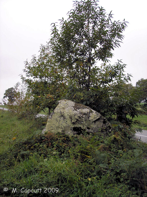
Pierre de Minoz submitted by thecaptain on 11th Nov 2009. Although right beside the D28 on the left bank of the river Fremur, the Pierre de Minoz hides behind a chestnut tree.
(View photo, vote or add a comment)
Log Text: None
Allée Couverte de Roche-Plate
Date Added: 18th Sep 2010
Site Type: Passage Grave
Country: France (Bretagne:Ille-et-Vilaine (35))
Visited: Yes on 29th Nov 2009
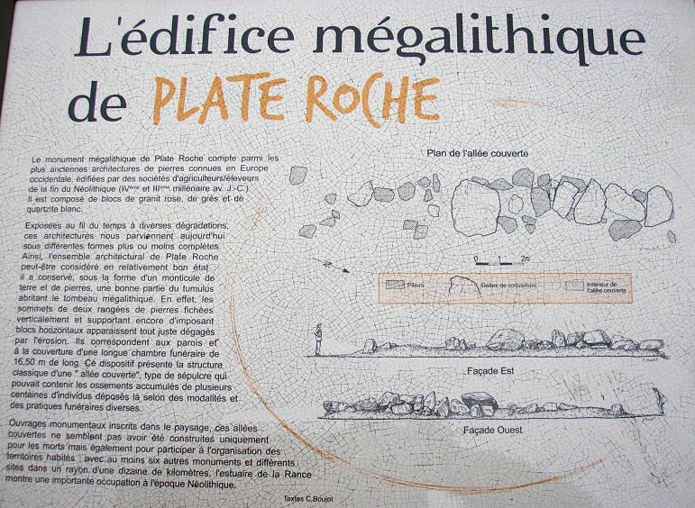
allée couverte de Roche-Plate submitted by thecaptain on 29th Nov 2009. Part of the noticeboard at the site.
(View photo, vote or add a comment)
Log Text: None
Quebec ice dolmen
Date Added: 18th Sep 2010
Site Type: Modern Stone Circle etc
Country: Canada
Visited: Yes on 22nd Dec 2009
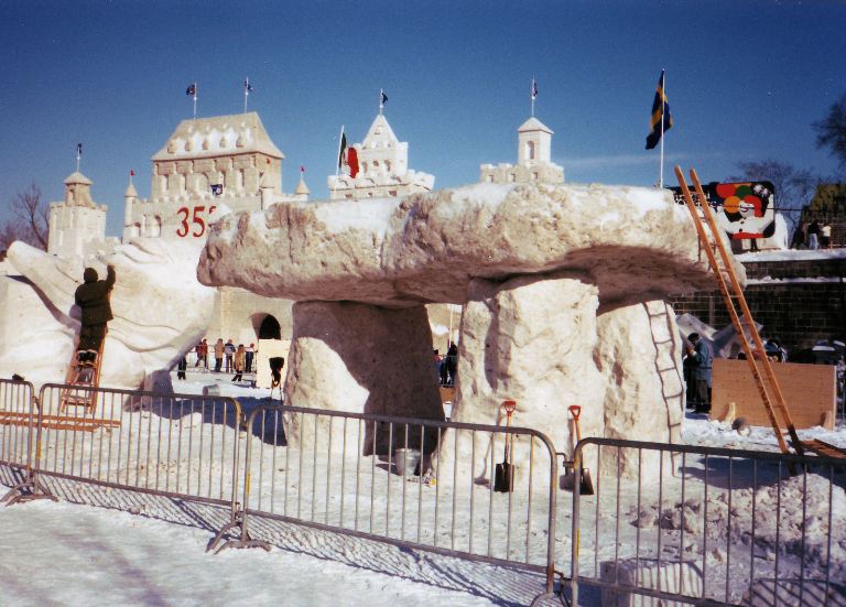
Quebec ice dolmen submitted by theCaptain on 22nd Dec 2009. Each year in February, the wonderful city of Québec holds a massive winter carnival, the Carnaval de Québec. Among the many events and festivities is an ice sculpture competition, with entries from around the whole world.
The year I visited, 1989, amongst all of the various ice carvngs and sculptures, there was a massive ice dolmen, made I believe by some Breton people. I could not of course, pass it by without taking a photograph.
(View photo, vote or add a comment)
Log Text: None
