Contributory members are able to log private notes and comments about each site
Sites TheCaptain has logged. View this log as a table or view the most recent logs from everyone
Caerloggas Down longstone
Date Added: 29th Oct 2019
Site Type: Modern Stone Circle etc
Country: England (Cornwall)
Visited: Yes on 9th Dec 2012
Caerloggas Down longstone submitted by theCaptain on 9th Dec 2012. A large standing stone, about 6 feet tall surrounded by 5 other stones on a large bump in the ground, with many other stones placed around it, perhaps making twin concentric circles. I assume its a newly erected stone feature.
(View photo, vote or add a comment)
Log Text: None
Zennor Churchyard Crosses
Date Added: 29th Oct 2019
Site Type: Ancient Cross
Country: England (Cornwall)
Visited: Yes on 18th Dec 2012

Zennor Churchyard Crosses submitted by theCaptain on 18th Dec 2012. Not strictly speaking megalithic, but while at Zennor it would be almost criminal not to pay your respects to the Mermaid.
Within St Senara's church, the Mermaid on her small pew is now carefully displayed, with the daylight of a big south window lighting her up. Tremendous.
The church notes suggest it is of medieval origin, more than 600 years old.
(View photo, vote or add a comment)
Log Text: None
Boswarthen Cross
Date Added: 29th Oct 2019
Site Type: Ancient Cross
Country: England (Cornwall)
Visited: Yes on 19th Dec 2012

Boswarthen Cross submitted by theCaptain on 19th Dec 2012. A very nice wheel head cross.
The southeastern face has an equal armed cross with widening ends, while the lower part of the cross extends down the shaft.
(View photo, vote or add a comment)
Log Text: None
The Stones, Tresallyn Cross
Date Added: 5th Nov 2019
Site Type: Modern Stone Circle etc
Country: England (Cornwall)
Visited: Yes on 28th Sep 2012. My rating: Condition 4 Ambience 3 Access 5
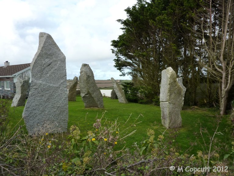
The Stones, Tresallyn Cross submitted by theCaptain on 20th Dec 2012. The stone circle at Tresallyn Cross
(View photo, vote or add a comment)
Log Text: The garden of author and artist Ed Prynn's bungalow at Tresallyn Cross, St Merryn, just a few miles from the Padstow to Wadebridge road, is a site to be seen. All sorts of megalithic monuments have been recreated here using roughly hewn modern Cornish granite. There is a stone circle, a men-an-tol, a rocking stone, a triangular Tolvan stone (the Wedding Stone) and a large Lanyon quoit style construction (the Angels Runway), and there is even a fougou constructed under the lawn. Many other stones and and artefacts are to be seen, including wishing well, maze and suchlike.
Carnewas Longstone
Date Added: 29th Oct 2019
Site Type: Standing Stone (Menhir)
Country: England (Cornwall)
Visited: Yes on 3rd Jan 2013
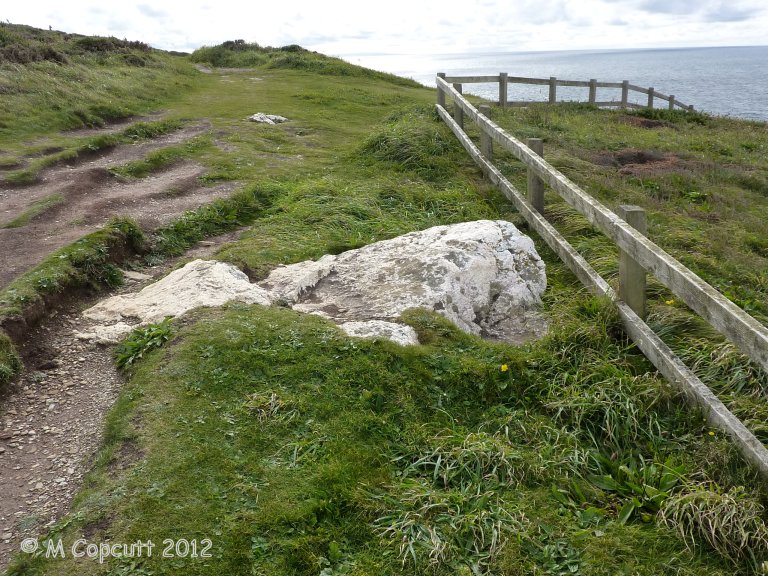
Carnewas Longstone submitted by theCaptain on 3rd Jan 2013. There are several other large quartzy blocks laying around in the Bedruthan Steps clifftop area at various places.
(View photo, vote or add a comment)
Log Text: None
The Fiddler
Date Added: 5th Nov 2019
Site Type: Standing Stone (Menhir)
Country: England (Cornwall)
Visited: Yes on 28th Sep 2012. My rating: Condition 3 Ambience 4 Access 4
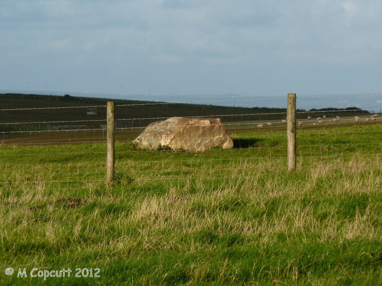
The Fiddler submitted by theCaptain on 3rd Jan 2013. Nowadays not much more than a large lump of stone laying in a field to the east of the A39 on the highpoint of land as the road passes over St Breock downs. It is positioned at a point where the line of the 9 Maidens would cross the top of the ridge.
(View photo, vote or add a comment)
Log Text: Nowadays not much more than a large lump of stone laying in a field to the east of the A39 on the highpoint of land as the road passes over St Breock downs. It is positioned at a point where the line of the 9 Maidens would cross the top of the ridge.
It is lovely light up here this afternoon, but the stone is across a fence from where I can walk to up the farm track, and the field full of livestock. It doesn't look that exciting, so I'll satisfy myself with taking pictures from the edge of the field. There is so much other large stone all around up here, that it is impossible to really tell what would be megalithic and what is field clearance.
St Breock Downs Menhir
Date Added: 5th Nov 2019
Site Type: Standing Stone (Menhir)
Country: England (Cornwall)
Visited: Yes on 28th Sep 2012. My rating: Condition 3 Ambience 3 Access 4
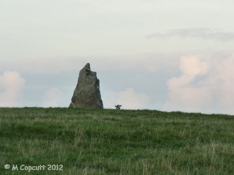
St Breock Downs Menhir submitted by theCaptain on 7th Jan 2013. Splendidly positioned and lit up when the sun goes down, but was too late with my photos.
This stone seems to have a guardian
(View photo, vote or add a comment)
Log Text: As we arrived, this ridgetop stone was lit up by the falling sun, on the top of the ridge below the wind turbines, and looked absolutely splendid. However, didn't stop, as Men Gurta and the newly refound kistvaen were more pressing in the light. Returned after visiting those, and the sun had gone down, making this stone look much less impressive. A full visit would have required crossing a fence into a field of sheep, so again I satisfied myself with taking a few photos from the edge of the field. Wish I'd spent a minute on the way up to quickly take a picture of it lit up in the sun!
St Breock Beacon Kistvaen
Date Added: 5th Nov 2019
Site Type: Burial Chamber or Dolmen
Country: England (Cornwall)
Visited: Yes on 28th Sep 2012. My rating: Condition 2 Ambience 2 Access 4

St Breock Beacon Kistvaen submitted by theCaptain on 17th Dec 2012. Recently rediscovered underneath a heavily overgrown region of scrub, just to the southwest of Men Gurta. It basically consists of two large stone slabs, one leaning on the other.
(View photo, vote or add a comment)
Log Text: Recently rediscovered underneath a heavily overgrown region of scrub, just to the southwest of Men Gurta, this monument was first recorded by William Borlase in his 1872 work Naenia Cornubiae.
It basically consists of two large stone slabs, one leaning on the other. I found it by walking in a southwesterly direction from Men Gurta across scrubland and then down a track towards the trigpoint. Just after crossing a farmtrack, there is an area of very overgrown gorse bushes, which seem to nowadays be used for dumping and tipping waste and junk. From on top of one of the piles of rubble, I had a good look around, and saw the large stones not far away, but impossible to reach from my position. Having another attempt from a more easterly position, I managed to get through the waist high gorse and brambles, while at times I found myself in water almost up to my knees! The things we stonehunters put ourselves through.
When I eventually got to the stones, I couldn't see much, as the surrounding area was so waterlogged and they are so overgrown, but it is clear they are a megalithic construction. With this now back on the megalithic map, I am sure others will be able to get better pictures and descriptions of this during better conditions, and before it becomes totally covered in the rubble and junk tipped up here.
Water Music Stone
Date Added: 29th Oct 2019
Site Type: Standing Stone (Menhir)
Country: England (Cornwall)
Visited: Yes on 14th Jan 2013
Water Music Stone submitted by theCaptain on 14th Jan 2013. The view from further up the lane to the east.
(View photo, vote or add a comment)
Log Text: None
Men Gurta
Date Added: 5th Nov 2019
Site Type: Standing Stone (Menhir)
Country: England (Cornwall)
Visited: Yes on 28th Sep 2012. My rating: Condition 4 Ambience 4 Access 4
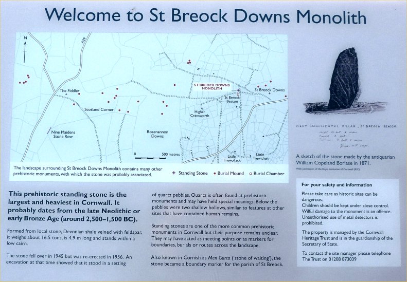
Men Gurta submitted by TheCaptain on 25th Mar 2013. There is a useful littel noticeboard up here, describing the stone and the local areas other prehistoric monuments
(View photo, vote or add a comment)
Log Text: Near the top of St Breock Down, this stone is easily reached along the little lanes to the south of Wadebridge. Men Gurta is the largest and heaviest standing stone in Cornwall. It is very nice up here in the sinking sun, with some terriffic views out to sea over the Camel estuary. I think the wind turbines add to the scene up here, other than their constant whining.
The Hurlers causeway
Date Added: 9th Sep 2025
Site Type: Ancient Trackway
Country: England (Cornwall)
Visited: Yes on 21st Sep 2013. My rating: Condition 2 Ambience 4 Access 4

The Hurlers causeway submitted by theCaptain on 22nd Sep 2013. the "quartz pavement" starting to become visible on a vile wet and windy moorland day, Saturday morning, 21 Sept 2013.
(View photo, vote or add a comment)
Log Text: During an unrecorded dig in about 1936, a "crystal causeway" was found and uncovered between the central and northern stone circles of The Hurlers, near Minions on Bodmin Moor. When a photo of this causeway was accidentally rediscovered, a new archaeological dig was organised by the local community and archaeologists to refind this causeway, and hopefully be able to discover more about it. This investigation happened to coincide with the last few days of our holiday in Padstow, and so it was decided to come and visit the site on the Saturday morning on the way home. It was a horrible grey wet morning, with typical Cornish horizontal moorland drizzle, which varied between almost dry and torrential. The place was very busy, and the first carpark was full when we arrived at about 11:15, so parking in the second car park, we visited the Moorland visitor centre in the old mining engine house first, which had a little exhibition all about the various features to be found on the moor here, and also a good little display about the current investigations of the Hurlers Circles, for both the astronomical observations and the intended dig. I was most intrigued to see mention of a possible "newfound stone circle" stated to be north of the three known circles, and also a possible new "avenue" of two roughly parallel stone rows to be found some distance away to the north of the circles, features identified by amongst others Peter Herring, the well known Bodmin Moor survey and write up chap. After that I took Dad to see the Rillaton Barrow, and the stone lined chamber in the side from where the famous gold cup was found. Now quite wet, and both with soaking feet, we now walked south to the Hurlers circles, on the way stopping to look at some of the mining pits, granite quarrying pits and then when nearing the circles also at a couple of large flat stones which just might have been standers once, and I was trying to imagine if there was once a circle here. I was not 100% convinced. Further on and between the middle and northern circles was a large fenced off area within which the archaeological investigations were being conducted. There was a large "trench" cut between the two circles, with the turfs all carefully stacked up along the outside, while about 20 diggers were active on the inside, scraping away at the clearly seen causeway, which was only a couple of inches below ground level. At this stage it was all very brown and muddy, and not at all like the gleaming "crystal causeway" as seen in the old photographs. From what I saw, I would estimate it was about a metre in width, and stretched for about 10 metres, not reaching to the circles at either end. The stones looked to me to be the regular moorland granite rather than quartz, ranging in size from a couple of inches up to about a foot in diameter. The causeway had clearly been deliberately made, with fairly regular edges, and the top surface was overall quite level, although locally very uneven, and would not have been particularly easy to have walked on. I found a lady archaeologist who was discussing things with some people and went to have listen to see what she was saying, and then had a quick discussion about it and we were told that a couple of flint tools had already been found within the makeup of the causeway, so probably dating it to the bronze age. They were hoping to uncover a lot more before the end of the investigation on monday, and also to clean it up for photographs, hopefully to a fairly gleaming state, although she said it was mostly granite and not the hoped for quartz. I took the opportunity to ask about the recently found "possible new stone circle" to the north, and the "possible avenue / two stone rows". After Dad told her who I was (I said I help run the megalithic portal) the lady seemed fairly keen to discuss these with me and very helpfully showed me some scale plans which she had, from which I could estimate their supposed whereabouts and where I was likely to find them. She said that they were very difficult to find, and that an experienced eye was needed to find anything, along with an "eye of faith" to be able to interpret them ! Well, if that wasn't a challenge to me, I don't know what is, even in this horrid weather. There were many other people around hoping to ask her stuff, so I didn't want to keep her long, and said that I would go off and look for these possible new features, parting to a response along the lines of good luck, it would be nice to know your thoughts. Pacing out from the north circle, I soon lost count and had to estimate my position, which was not the easiest thing to do in the mist, completely unable to recognise any features away from the local moorland! I found the stones I had had a look at on the way to the circles, but thought they were perhaps a bit to near to the circles, but was unable to find anything else in the vicinity. Now having an idea of what I was looking for, I was still not sure I had found the correct site, but using my best imagination, then yes, possibly there was a circle here once. Now off across the rough and wet moorland into the murk, and tring to mentally triangulate between the three circles (thankfully visible due to the fencing and dig equipment), Rillaton Barrow on its hilltop position, and down into the little valley with the trackway was a nice challenging task, and I soon realised I was in the wrong position and then had to tramp out further away, now losing any visibility of the circles! Dad was wondering what on Earth we were doing walking out here, and commented not only about getting wet, but getting totally lost, turning round and not having any idea where we were or what way we were facing!. But my instincts and internal navigation mode was working well for me, and a little break in the gloom allowing a glimpse of Stowes Hill and the Cheesewring confirmed where I was. Right, they must be somewhere about here, running in that direction, and just about 10 metres away, there I could see three stones standing proud of the long moorland grass, lined up and evenly spaced. A closer look, and yes, I am sure this is it, then another little gap in the mist allowed Stowes hill to be seen again, and confirmed that the row is aligned to the west of that, and perhaps aligned on Kilmar Tor in the distance, as the archaeologist lady had said. Looking around further, and yes, it looks like a second row is there about 10 metres to the right, slightly up slope, again with three stones to be seen aligned in about the same direction, and spacing beween the stones about the same. Walking along the upper row, and yes, more and perhaps more stones are there which could be considered as part of the same row, with an even spacing, until they ran into much rougher ground and ferns, getting completely lost. This seemed to be true for both of the rows of stones, which I thought were easy to find from the south, but would be pretty impossible to find from the north or any other direction. So, yes, I am totally convinced about these rows / avenue, and have found much lesser monuments elsewhere on my moorland treks! Dad was now asking about the miners cave he had read about, so I told him I was sure I could find that if he wanted, but it was very wet, and getting late for lunch, so we decided to give up and return to the car and go get lunch. On the way we called bac to the circles and the dig, which was now in lunch mode, with the lead lady and others sat around with thermos flasks and lunch. I called over to her, and said that I liked the rows, and was pretty certain thet these really existed, but not sure that I found the circle, following which we sort of agreed that sometimes you could find these things, and sometimes not, it all depends upon the lighting, direction you approach from, combined with an experienced eye for these things and a lot of luck! As we parted, she said it was good to have another experienced opinion on them, and then I heard her telling her companions that I was from The Megalithic Portal, and it was good that we were there having a look and reporting on their dig! Before getting much further, I overheard a large bloke I had seen as part of the dig discussing how to find the Craddock Moor stone circle with a lady and her dog, both saying that they had often looked for it but not been able to find it, the archaeologist chap saying he'd looked for it 5 times, but only been able to find it once, although one time he had the handicap of the moor being snow covered! I had to butt in and light heartedly say that it was easy to find, walk out along the tracl to the barrow, then turn left and head out over the moor for a while, and the circle was easy to find as there was a large bush right by it! We then agred that it all depended on what the conditions were at the time, and whether the circle wanted to be found or not, again agreeing that it was preferable that these sites can retain their secrets and mysteries, and not let just anyone find them! Another stop off on the way back to the car was the digging teams base, where there were some tents with equipment in, and many of the digging team inside out of the bad weather having lunch, so we did not interfere with them anymore. There was also a lady discussing how to skin animals and turn the skins into hide, but we decided to get on, as time is getting on and we dont want to miss lunch. Got back to the car about 1:45, and dropped down off hte moor to Upton Cross and the Caradon Inn, which I haven't been to in nearly 30 years, which was thankfully still open and doing a good lunch.
Dinas Head (Trevose)
Date Added: 29th Oct 2019
Site Type: Promontory Fort / Cliff Castle
Country: England (Cornwall)
Visited: Yes on 7th Jan 2014

Dinas Head (Trevose) submitted by theCaptain on 7th Jan 2014. Photo of Dinas Head, Trevose, taken during the recent storms, showing the waves washing over the height of the headland. Borrowed from Gregg Painter and Cornwall Holiday guide.
I thought this photo would be useful to compare with my recent notes from here, but it looks like I have yet to upload them and my pictures!
Have to say that only yesterday I was wishing I was here to check on my theory, that this whole headland may have been washed clear by the waves, now I know that it is in...
(View photo, vote or add a comment)
Log Text: None
Mayon Cliff cairn
Date Added: 5th Aug 2022
Site Type: Cairn
Country: England (Cornwall)
Visited: Yes on 14th Jun 2022. My rating: Condition 3 Ambience 5 Access 4
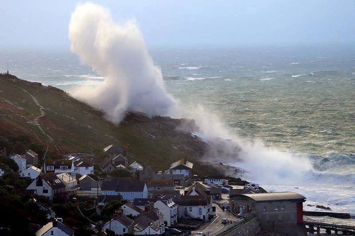
Mayon Cliff cairn submitted by theCaptain on 7th Jan 2014. Photo taken during the recent storms showing the force of the waves crashing onto Mayon Cliff above Sennen Cove. There is also a video available which shows the whole of the cliff completely awash.
Photo by Tony Armstrong Photography with their wishes for it to be shared.
(View photo, vote or add a comment)
Log Text: From Sennen Cove, I decide to walk up to the coastguard lookout shelter and on to look at the shipwreck of the RMS Mülheim, wrecked March 2003, the path passing right beside the Mayon Cliff cairn, and with the cliff castle clearly visible the other side.
Dinas Head Tumulus
Date Added: 29th Oct 2019
Site Type: Round Barrow(s)
Country: England (Cornwall)
Visited: Yes on 9th Jan 2014

Dinas Head Tumulus submitted by theCaptain on 9th Jan 2014. Right on the top of the headland is the remains of what is described as Tumulus. The mound is about 8 metres diameter, still more than one metre in height, and largely composed of white quartzy looking rock.
(View photo, vote or add a comment)
Log Text: None
Winecove Point N
Date Added: 29th Oct 2019
Site Type: Promontory Fort / Cliff Castle
Country: England (Cornwall)
Visited: Yes on 18th Jan 2014
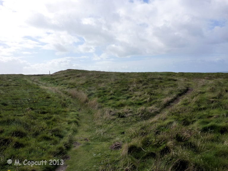
Winecove Point N submitted by theCaptain on 18th Jan 2014. The northernmost of the three promontory cliff forts south of Treyarnon, has a fairly small single ditch and bank remains, dividing off only the far tip of the headland between Trethias Island and Wine Cove.
(View photo, vote or add a comment)
Log Text: None
Winecove Point mid
Date Added: 29th Oct 2019
Site Type: Promontory Fort / Cliff Castle
Country: England (Cornwall)
Visited: Yes on 18th Jan 2014

Winecove Point mid submitted by theCaptain on 18th Jan 2014. The central of the three promontory cliff forts south of Treyarnon Bay, has a large double ditch and bank which cuts off the entire headland between Wine Cove to the north and Pepper Cove to the south.
The ditches have been cut right down into the solid rock.
(View photo, vote or add a comment)
Log Text: None
Winecove Point S
Date Added: 29th Oct 2019
Site Type: Promontory Fort / Cliff Castle
Country: England (Cornwall)
Visited: Yes on 18th Jan 2014
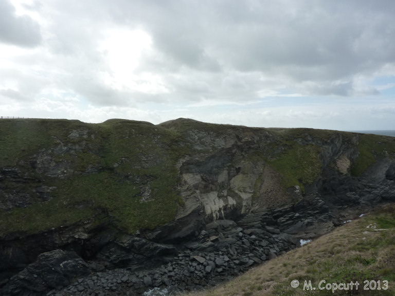
Winecove Point S submitted by theCaptain on 18th Jan 2014. The southernmost of the three promontory cliff forts south of Treyarnon Bay, has a large double ditch and bank which cuts off the entire headland between Pepper Cove to the north and Warren Cove to the south, whilst a further single ditch and bank is present at about halfway out onto the headland.
(View photo, vote or add a comment)
Log Text: None
Delford Bridge
Date Added: 29th Oct 2019
Site Type: Standing Stone (Menhir)
Country: England (Cornwall)
Visited: Yes on 23rd Jan 2014

Delford Bridge submitted by theCaptain on 23rd Jan 2014. A stone can be seen standing on top of a small raise in the field to the southwest of the lovely Delford Bridge.
(View photo, vote or add a comment)
Log Text: None
The Hurlers North
Date Added: 8th Sep 2025
Site Type: Stone Circle
Country: England (Cornwall)
Visited: Yes on 21st Sep 2013. My rating: Condition 1 Ambience 3 Access 4
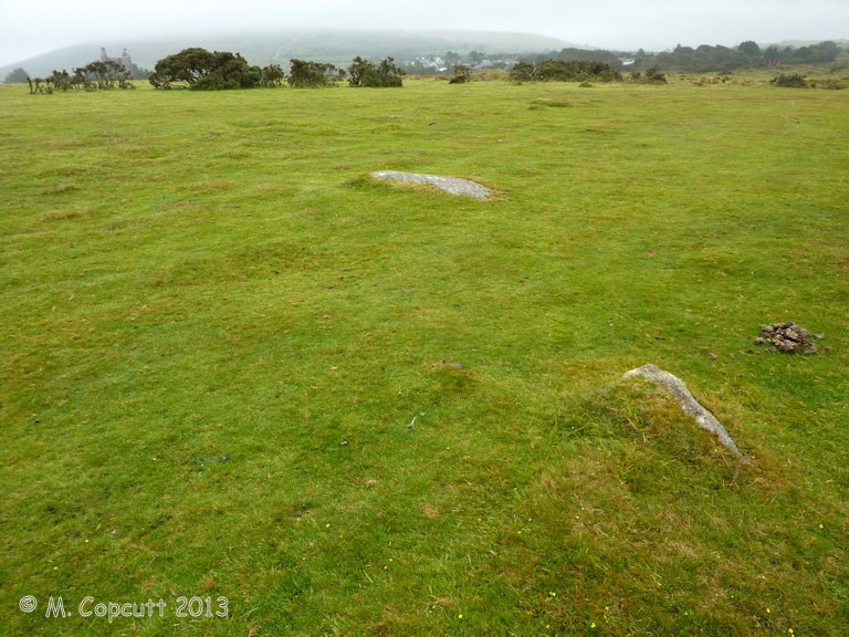
The Hurlers North submitted by theCaptain on 25th Jan 2014. Possible newly recognised fourth stone circle to the north of the three well known Hurlers circles.
A few stones slightly poke through the turf, with others hidden, and with an "eye of faith" a circle can be made out.
(View photo, vote or add a comment)
Log Text: Possible newly recognised fourth stone circle to the north of the three well known Hurlers circles. A few stones slightly poke through the turf, with others hidden, and with an "eye of faith" a circle can be made out. This circle is smaller than the main three Hurlers circles, but is in line with them, about the same distance north of the northern circle as the distance between the main three. Thanks to the people digging at The Hurlers for this information, first noted by Peter Herring in 2009.
The Hurlers Avenue
Date Added: 8th Sep 2025
Site Type: Multiple Stone Rows / Avenue
Country: England (Cornwall)
Visited: Yes on 21st Sep 2013. My rating: Condition 2 Ambience 3 Access 3

The Hurlers Avenue submitted by theCaptain on 25th Jan 2014. Possible remains of a newly discovered stone avenue, running in an approximately north to south direction, on the moor to the north of the Hurlers stone circles.
From what I saw the two approx parallel lines of stones are about 15 metres from each other, and stones can be found at about 10 metre spacings.
(View photo, vote or add a comment)
Log Text: Possible remains of a newly discovered stone avenue, running in an approximately north to south direction, on the moor to the north of the Hurlers stone circles. From what I saw (Sept 2013) the two approximately parallel lines of stones are (from memory) about 15 metres from each other, and stones can be found at about 10 metre spacings. The rows seemed fairly definite and "easy" to spot approaching from the south, and disappeared into the rougher and fern covered ground to the north. Thanks to the people digging at The Hurlers for this information, first noted by Peter Herring in 2009.
