Contributory members are able to log private notes and comments about each site
Sites Stonetracker has logged. View this log as a table or view the most recent logs from everyone
Kerlescan cromlech
Date Added: 10th Oct 2024
Site Type: Stone Circle
Country: France (Bretagne:Morbihan (56))
Visited: Yes on 1st Sep 2024. My rating: Condition 3 Ambience 4 Access 3

Kerlescan cromlech submitted by LizH on 31st Oct 2007. The eastern stones of the western Kerlescan cromlech. The stones touch each other and face across (N-S) rather than being aligned E-W as the rows are.
(View photo, vote or add a comment)
Log Text: Kerlescan cromlech is probably the most intact of the main alignment cromlechs stretching from Menec through Kerlescan. Many of the stones on the south, west, and particularly the east sides are still in place. The northern stones are gone. Normally the area including the Kerlescan rows is fenced off in the summer, but I lucked out in Sept when I discovered later that one gate was open.
Even when closed, there are trails next to the equestrian center that get you close to stones on the western side and at various cleared spots along the fence there are vistas that allow photography of the other sides from a distance.
Car parking is available in a public lot next to the private equestrian center on the D196
Kerlescan nord allée couverte
Date Added: 13th Oct 2024
Site Type: Passage Grave
Country: France (Bretagne:Morbihan (56))
Visited: Yes on 1st Sep 2024. My rating: Condition 2 Ambience 4 Access 2
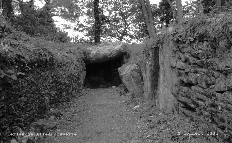
Kerlescan nord allée couverte submitted by Martin_L on 22nd Jan 2009. Inside the chamber.
(May 2001)
(View photo, vote or add a comment)
Log Text: At least for me, this was difficult to find, as there was no signposting and there was no obvious public parking nearby. I tried to shortcut it through a private field from a trail near the Kerlescan Tertre and was greeted with horses and no trespassing signs. Ultimately I parked near the equestrian center, walked along the southern side of the Kerlescan Alignments to nearly their end, took a left onto a road that looked like someone's driveway and then picked my way north through a maze of (private?) trails to the site. The whole thing wound up being about 1.5 km one way, so I got plenty of exercise. ;-) There may have been easier access points somewhere else...
Kerlescan North Cromlech
Date Added: 13th Oct 2024
Site Type: Stone Circle
Country: France (Bretagne:Morbihan (56))
Visited: Yes on 1st Sep 2024. My rating: Condition 2 Ambience 3 Access 3
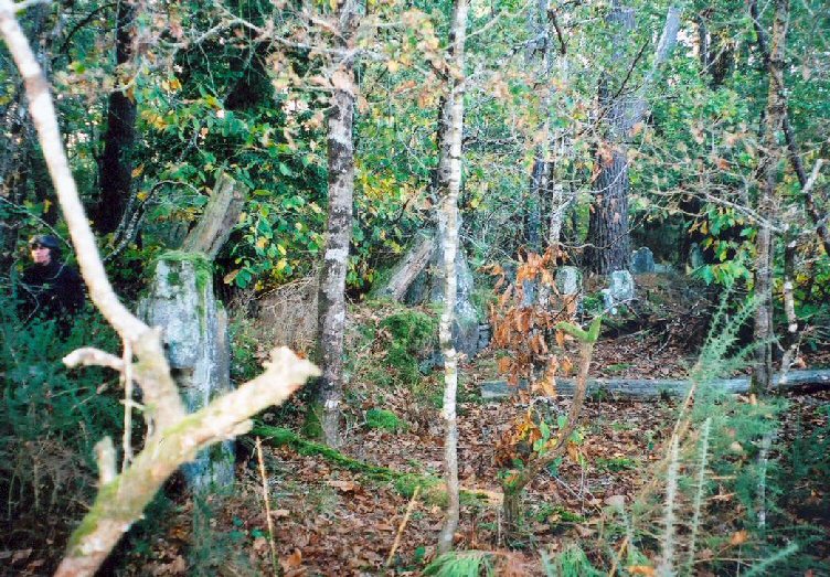
Kerlescan North Cromlech submitted by LizH on 31st Oct 2007. This shows some of the stones on what would be the western side of the cromlech, embedded in a more modern wall.
The trees and gorse are also visible. This was taken in one of the most open stretches of the wooded area, so not indicating how difficult it in fact was to see or move!
(View photo, vote or add a comment)
Log Text: This is the "other" cromlech at Kerlescan, about 100 m north of the Kerlescan tertre. Much seems to have changed since the photo by Lizh was posted. If you follow the fence line past the Kerlescan Tertre/Menhir, a very obvious wide trail eventually deviates off to the north into the wood. Trees have been cleared out quite a bit.
Soon you start seeing what look like obvious menhirs on the right side of the trail and roughly at the listed coordinates. However a much more recent embankment and stone wall was built and connects many of the taller stones. Is it what's left of this mysterious cromlech? With so little information to go on, it's hard to say but I'm guessing it is. If so, this is one side of it, and I didn't attempt a bushwhack to see if I could find anything else.
Car parking for this site is at a public lot next to the equestrian center. It's a fair trail walk from there to the site, maybe 0.7 km.
Kerlescan Tertre and menhir
Date Added: 12th Oct 2024
Site Type: Standing Stone (Menhir)
Country: France (Bretagne:Morbihan (56))
Visited: Yes on 1st Sep 2024. My rating: Condition 3 Ambience 4 Access 4
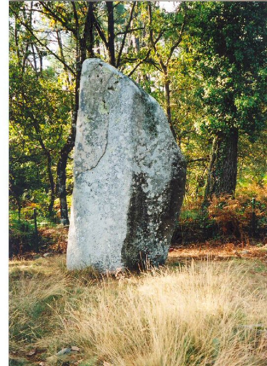
Kerlescan Tertre and menhir submitted by LizH on 31st Oct 2007. This stone stands at the west end of the Kerlescan rows, but to the north of them, at the western end of what was once a tumulus.
The small bear (Barnaby) at the bottom is from Hallbankgate school and is making a tour of pre-historic sites!
(View photo, vote or add a comment)
Log Text: This tertre and menhir are located in what would have been the NW corner of the main cromlech at Kerlescan. Normally this area is fenced off in summer, although you can still get quite close to these features along the fence line. Only later did I realize one of the gates was open, providing much closer access.
Car parking is available in a public lot next to the equestrian center off the D196. A trail leads around the horse stables to the site.
Kerloguen Cross
Date Added: 8th Oct 2024
Site Type: Ancient Cross
Country: France (Bretagne:Morbihan (56))
Visited: Yes on 1st Sep 2024. My rating: Condition 3 Ambience 3 Access 5
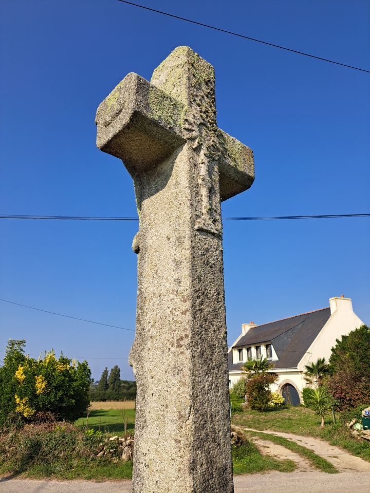
Kerloguen Cross submitted by stonetracker on 7th Oct 2024. Site in Bretagne:Morbihan (56) France
(View photo, vote or add a comment)
Log Text: Right on the north side of the Crucuno road on the way to the Crucuno dolmen. There is a layby across the street.
Rather eroded condition and age is unclear, but unmistakably a depiction of a crucifixion.
Kermario Alignements
Date Added: 7th Oct 2024
Site Type: Multiple Stone Rows / Avenue
Country: France (Bretagne:Morbihan (56))
Visited: Yes on 1st Sep 2024. My rating: Condition 4 Ambience 5 Access 4
Kermario alignements submitted by rw1 on 20th Jan 2008. 09/2007
(View photo, vote or add a comment)
Log Text: What can I say that hasn't already been said ? Astounding site and still one of many unsolved mysteries.
On a more mundane note, there are many ways to explore these alignments. For me, parking at the large lot near the Kermario Dolmen and walking the southern rows from there to the Old Windmill viewing tower and then back along the northernmost row provided the most satisfying on-the-ground experience. But be advised that it's a fair trek !
Kermario Dolmen
Date Added: 7th Oct 2024
Site Type: Burial Chamber or Dolmen
Country: France (Bretagne:Morbihan (56))
Visited: Yes on 1st Sep 2024. My rating: Condition 3 Ambience 4 Access 4
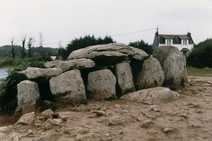
Kermario Dolmen submitted by thecaptain on 18th Oct 2004. Kermario Dolmen, north of Carnac, Brittany.
View of the Kermario Dolmen which is right at the southwest corner of the Kermario Alignements, and right in the corner of the road which skirts the site.
This picture was taken in 1987 when people were free to wander amongst the stones as they pleased. The terrible erosion caused by all the visitors is only too obvious.
(View photo, vote or add a comment)
Log Text: Park in the large public lot at the western end of the Kermario alignments. This is a good base to explore both the dolmen and the Kermario alignments.
Kerzerho Alignements
Date Added: 30th Sep 2024
Site Type: Multiple Stone Rows / Avenue
Country: France (Bretagne:Morbihan (56))
Visited: Yes on 1st Sep 2024. My rating: Condition 4 Ambience 5 Access 5
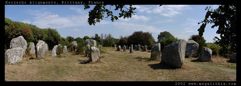
Kerzerho Alignements submitted by ermine on 1st Jul 2004. Kerzerho Alignments
Brittany, Morbihan
47.634690N 3.148402W GPS onsite
You can still walk among the stones at Kerzerho (in 2002 at east) which are near Carnac but not quite so busy. Head up the D781 to Erdeven. You can park nearby, and from there you can also take the path to the large stones of the Table du Sacrifice
(View photo, vote or add a comment)
Log Text: Entrance is normally via a dirt car park on the east side of D781, right next to a trail passing by the stones. However, the car park was closed off and dug up when I was there, presumably for some construction improvement work. There are a few limited pulloffs on the west side of D781 so I parked there instead.
The alignments straddle D781, with far fewer remaining on the west side of the highway than the east side. Access among the stones on the east side is still unrestricted. It is thought by some that the stones on the west side of D781 are what's left of a cromlech, now long gone
Kings Crossing Mounds
Date Added: 4th Feb 2023
Site Type: Artificial Mound
Country: United States (The South)
Visited: Yes on 1st Oct 2022. My rating: Ambience 2
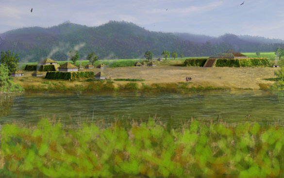
Kings Crossing Mounds submitted by stonetracker on 4th Feb 2023. Artist's conception of the site. Mound A is on the right.
(View photo, vote or add a comment)
Log Text: Attempted to visit this site, but Mound A is apparently on private property behind some houses. Protective neighborhood dogs dissuaded me from making more of an effort. Mound C may be more accessible behind an abandoned church but I didn't have time to try. The area is very overgrown and winter may be a better time to go there.
La Dame Du Manio
Date Added: 9th Oct 2024
Site Type: Standing Stone (Menhir)
Country: France (Bretagne:Morbihan (56))
Visited: Yes on 1st Sep 2024. My rating: Condition 4 Ambience 4 Access 4
La Dame Du Manio submitted by karolus on 24th Jun 2018. Site in Bretagne:Morbihan (56) France
(View photo, vote or add a comment)
Log Text: Located as described, about 20 m NW of the Pierre Carree along a narrow footpath
La Pierre Carree
Date Added: 9th Oct 2024
Site Type: Standing Stone (Menhir)
Country: France (Bretagne:Morbihan (56))
Visited: Yes on 1st Sep 2024. My rating: Condition 4 Ambience 4 Access 4
La Pierre Carree submitted by karolus on 24th Jun 2018. Site in Bretagne:Morbihan (56) France
(View photo, vote or add a comment)
Log Text: Located as described, about 20-30 m west or southwest of the Geant du Manio on a narrow footpath.
La Salle Street Mound
Date Added: 10th Mar 2025
Site Type: Artificial Mound
Country: United States (The South)
Visited: Yes on 1st Feb 2025. My rating: Condition 3 Ambience 4 Access 5

La Salle Street Mound submitted by stonetracker on 10th Mar 2025. The mound and apartment building adjacent
(View photo, vote or add a comment)
Log Text: This mound is very close to Schicker Mound and on neighboring La Salle St. On-street parking is available on La Salle right next to the mound or across the street. It's also easy walking distance from Schicker. Unusually for Louisiana, you can walk right up to the mound as it abuts the sidewalk even though it's private.
La Table des Marchands
Date Added: 14th Nov 2024
Site Type: Burial Chamber or Dolmen
Country: France (Bretagne:Morbihan (56))
Visited: Yes on 1st Sep 2024. My rating: Condition 4 Ambience 5 Access 4
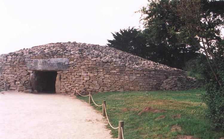
La Table des Marchands submitted by JJ on 9th Nov 2002. La Table des Marchands
(View photo, vote or add a comment)
Log Text: One of a triad of megalithic sites, all accessible via the Site des Megalithes Visitor Centre in Locmariaquer for a small admission fee. Like the Er-Grah Tumulus, parts of this passage grave were nearly buried or damaged but completely restored in the 1990s to what is thought to be its original appearance. Unlike Er-Grah, the passage and end chamber are open to the public and illuminated. Certain of the chamber pillars and capstone are covered with well preserved artwork.
La Table du Sacrifice
Date Added: 2nd Oct 2024
Site Type: Burial Chamber or Dolmen
Country: France (Bretagne:Morbihan (56))
Visited: Yes on 1st Sep 2024. My rating: Condition 4 Ambience 5 Access 4

La Table du Sacrifice submitted by LizH on 6th Nov 2007. In this picture, the furthest north stone (lying) can be seen. Behind it, however, at the back of the picture, this stone looks more as if it could be a 'table' and even possibly a 'sacrifice table' in the minds of those who named it. I am not sure which one is the official 'Table du sacrifice'.
(View photo, vote or add a comment)
Log Text: In the midst of the largest upright Geants are 2-3 huge, recumbent stones. It's anyone's guess which one qualifies for the Table du Sacrifice. But it's all good !
Lake George Mounds
Date Added: 4th Feb 2023
Site Type: Artificial Mound
Country: United States (The South)
Visited: Yes on 1st Oct 2022. My rating: Condition 3 Ambience 4 Access 5
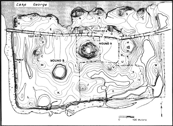
Lake George Mounds submitted by stonetracker on 4th Feb 2023. Useful map of site from an excavation in the 80s.
(View photo, vote or add a comment)
Log Text: All mounds are on private property, but Mounds A and B are clearly visible no more than a few 100 ft away from the car pull-off area on Satartia Rd. Mound A is right next to the road and can be viewed at close range via a short walk.
Law Mounds
Date Added: 2nd Nov 2023
Site Type: Artificial Mound
Country: United States (The South)
Visited: Yes. My rating: Condition 3 Ambience 3

Law Mounds submitted by stonetracker on 1st Nov 2023. Another zoomed view of Mound A from 1000 ft away, in late Oct.
(View photo, vote or add a comment)
Log Text: Visited Oct 2023. Spotted Mound A as described, about 1000 ft south of the Yazoo Refuge Rd in a cultivated field with no public access. The two remaining mounds appear to be gone.
Le Petit Ménec
Date Added: 17th Oct 2024
Site Type: Multiple Stone Rows / Avenue
Country: France (Bretagne:Morbihan (56))
Visited: Yes on 1st Sep 2024. My rating: Condition 3 Ambience 5 Access 3
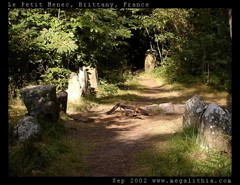
Le Petit Ménec submitted by ermine on 6th Aug 2004. Confusingly, Petit-Menéc is in fact at the opposite, eastern end of the alignments to le Menéc village at the western end. You need to turn left onto the D186 main road after continuing from Kerlescan. After about 250m turn right into a minor road going past a forest, there is a clearing where you can park after about 400m. The menhirs are in the forest on your right, arranged in a gentle curve. You don't get the same clear overview of the alignments since the view is obscured by the trees, bu...
(View photo, vote or add a comment)
Log Text: Could be my favorite stone alignment site in the Carnac area, as it is secluded in a forest and not on the heavily traveled tourist track. Serene atmosphere for sure.
This is also one of the few major alignment sites that is still unfenced and you can walk freely anywhere. Much like Kerzerho.
Directions to the site are as described.
Le Quadrilatere
Date Added: 9th Oct 2024
Site Type: Passage Grave
Country: France (Bretagne:Morbihan (56))
Visited: Yes on 1st Sep 2024. My rating: Condition 3 Ambience 4 Access 2
Le Quadrilatere submitted by rw1 on 3rd Mar 2008. 09/2007
(View photo, vote or add a comment)
Log Text: Site is accessible via an 0.7 km forest trail north from a parking lot. The lot is located directly across the D196 from the trail, at a low wetland spot just below where the Kermario alignments end and the Manio (Kerloquet) alignments begin.
Leland Mounds
Date Added: 2nd Mar 2025
Site Type: Artificial Mound
Country: United States (The South)
Visited: Saw from a distance on 1st Feb 2025. My rating: Condition 3 Ambience 4
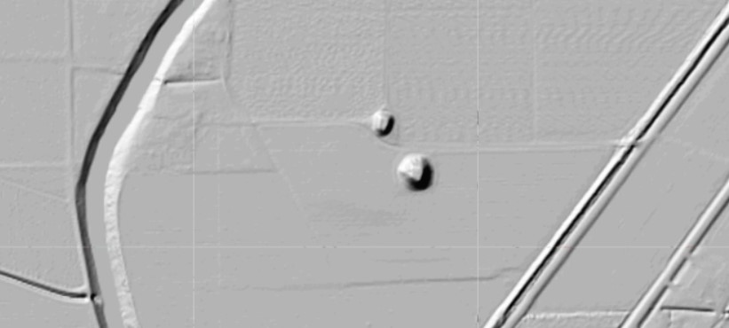
Leland Mounds submitted by stonetracker on 8th Dec 2023. Shaded relief map of same mounds shown in topo view.
(View photo, vote or add a comment)
Log Text: These Mississippian mounds fall into the same category as a number of others that can only be viewed from long range, e.g. Metcalfe, Stoneville, and Mayersville. All are privately owned and on either agricultural land or large compounds set far back from the nearest public road. Unless permission is secured by the landowner, be prepared to shoot photos or videos from several 100 ft or more away. The best and closest viewing spot I found was on Elizabeth Rd in Leland at approximately 33.41954, -90.88656 which lies about 1000 ft east of the mound. There is a safe parking shoulder near the landowner's driveway, where I captured most of the images. The two remaining mounds are on cultivated land and in good condition, particularly the largest (Mound A).
Lessley Mound
Date Added: 6th Mar 2025
Site Type: Artificial Mound
Country: United States (The South)
Visited: Yes on 1st Feb 2025. My rating: Condition 3 Ambience 4 Access 5

Lessley Mound submitted by stonetracker on 7th Mar 2025. The mound. Zoom in to the top to see the iron fence around the family cemetery.
(View photo, vote or add a comment)
Log Text: This mound is on the north side of MS Route 24, and right next to the roadway and a convenient parking pulloff at the interpretive sign. So it is possible to view it at close range without leaving the vehicle. However an old barbed wire fence prevents entry into a field on the other side of the mound. It is easily crossed but I respected the private property restrictions of the landowner.
