Contributory members are able to log private notes and comments about each site
Sites SandyG has logged. View this log as a table or view the most recent logs from everyone
Saith Maen WSW
Date Added: 7th Jan 2019
Site Type: Stone Row / Alignment
Country: Wales (Powys)
Visited: Yes on 20th Aug 2018. My rating: Condition 2 Ambience 4 Access 3
Saith Maen WSW submitted by cerrig on 24th Jan 2010. This is looking South. It's a quite overgrown and confused site now. I counted upwards of 20 stones in this "coral", there should be only 8.
(View photo, vote or add a comment)
Log Text: Limited parking is available at SN 94788 59199. Be careful not to block the adjacent farm entrance. From here walk north along the path to the row.
Tre Heslog Stone Row
Date Added: 15th Jan 2019
Site Type: Stone Row / Alignment
Country: Wales (Powys)
Visited: Yes on 20th Aug 2018. My rating: Condition 4 Ambience 4 Access 3
Tre Heslog Stone Row submitted by daijames on 7th Sep 2014. Tre Heslog Stone Row
(View photo, vote or add a comment)
Log Text: Limited car parking is available at SN 93263 69792. From here head south along the footpath. The row can be found a short distance from the footpath.
Kittuck
Date Added: 6th Feb 2020
Site Type: Multiple Stone Rows / Avenue
Country: England (Somerset)
Visited: Yes on 3rd Aug 2018. My rating: Condition 2 Ambience 4 Access 2
Kittuck submitted by SandyG on 21st Jan 2019. View from south east (Scale 1m).
(View photo, vote or add a comment)
Log Text: Car parking is available at SS 84543 44569. From here cross the road and enter the field to the west. Follow the track to SS 83382 43897 and then head to the gateway at SS 82609 44240. Then follow the field wall westward to another gate at SS 82416 44289. Pass through the gateway and head south to Three Combes Foot. From here follow the narrow path up the steep slope to the row.
Five Barrows (Devon)
Date Added: 15th Feb 2020
Site Type: Barrow Cemetery
Country: England (Devon)
Visited: Yes on 2nd Aug 2018. My rating: Condition 4 Ambience 5 Access 4
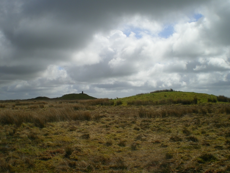
Five Barrows (Devon) submitted by roburite on 8th Apr 2014. Three of the barrows. A trig point is on the highest.
(View photo, vote or add a comment)
Log Text: None
White Ladder
Date Added: 23rd Jan 2019
Site Type: Multiple Stone Rows / Avenue
Country: England (Devon)
Visited: Yes on 2nd Aug 2018. My rating: Condition 3 Ambience 3 Access 5
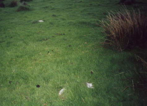
White Ladder submitted by TimPrevett on 5th Jul 2002. White Ladder Stone Rows
SS730373
Quartz stones are everywhere, scattered around loose on the ground. Thanks to the book Ancient Exmoor I was able to follow these quartz rocks on through the hedge at the back of the photo, across the road and into the field the other side, and for several hundred yards distance after the road.
Photo, visit & text by Roger Gay, South Molton, Devon. Scanning & editing by Tim Prevett.
(View photo, vote or add a comment)
Log Text: Roadside car parking is available next to the row at SS 73238 37254. This site is best visited after a prolonged period of dry weather when the rushes have been cut. The gateway leading to the site has subsequently been blocked and access to the field may now be along the road to the south.
Stannon stone setting
Date Added: 25th Jan 2019
Site Type: Standing Stones
Country: England (Cornwall)
Visited: Yes on 31st Jul 2018. My rating: Condition 3 Ambience 4 Access 5

Stannon stone setting submitted by TheCaptain on 28th Mar 2005. Stannon stone circle seen looking southeastwards from the strange little row of four outliers at SX12518007.
(View photo, vote or add a comment)
Log Text: Car parking is available at SX 12330 80127. From here it is a short walk to the row and adjacent stone circle.
Furzehill Common stone row
Date Added: 22nd Jan 2019
Site Type: Stone Row / Alignment
Country: England (Devon)
Visited: Yes on 30th Jul 2018. My rating: Condition 3 Ambience 4 Access 2
Furzehill Common stone row submitted by TheCaptain on 19th May 2010. Here I found four little stumps of stone in a row, in a boggy hollow on top of the ridge. They are spaced 2.5, 5, 2.5 metres apart, suggesting a missing stone in between those I could find.
(View photo, vote or add a comment)
Log Text: This row can be reached either by walking from Brendon Two Gates (SS 76507 43252) which takes you past the rows on Cheriton Ridge or from Shallowford (SS 71409 44955) which avoids a couple of steep climbs.
Inverewe
Date Added: 16th Feb 2020
Site Type: Class I Pictish Symbol Stone
Country: Scotland (Highlands)
Visited: Yes on 13th Jul 2018. My rating: Condition 2 Ambience 3 Access 5
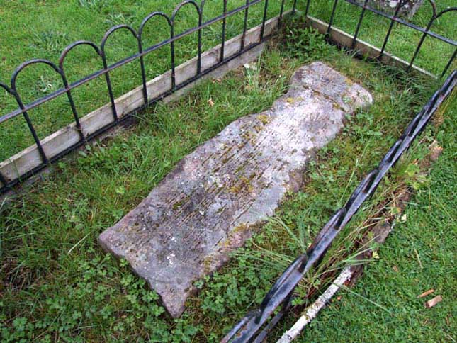
Inverewe submitted by andy_h on 14th Aug 2006. To be found in the ruined churchyard up the turning by the campsite, re-used as a grave slab. The stone is located at the back end of the ruined church and is a little hard to find, as it is very worn and looks much like other grave slabs around it. It depicts a crescent and a 'V'. Another Pictish stone can be seen in Gairloch Heritage Museum, which depicts a fish and the lower part of an eagle.
(View photo, vote or add a comment)
Log Text: Not sure I would have made the journey just to see this but I was staying at the nearby campsite for a few days and visited a few times to see if I could get the light right.
Corrimony
Date Added: 17th Feb 2020
Site Type: Clava Cairn
Country: Scotland (Highlands)
Visited: Yes on 13th Jul 2018. My rating: Condition 4 Ambience 4 Access 5
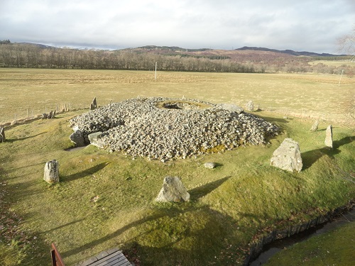
Corrimony submitted by mattchapman on 16th Mar 2016. Dry for once !
(View photo, vote or add a comment)
Log Text: None
Auldearn Stone Row
Date Added: 9th Jan 2019
Site Type: Stone Row / Alignment
Country: Scotland (Highlands)
Visited: Yes on 9th Jul 2018. My rating: Condition 2 Ambience 3 Access 5
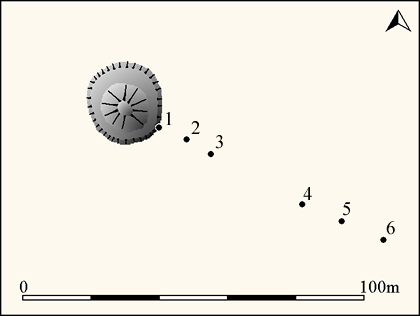
Auldearn Stone Row submitted by SandyG on 3rd Jan 2019. Plan of the Auldearn stone row showing the position of the numbered stones (Source OS 1:2500 1905 and sketch plan by V.G. Childe and A. Graham 1943).
(View photo, vote or add a comment)
Log Text: This row stands mainly in a private garden and permission to visit it should be sought at Stonerow House. Car parking is available nearby at NH 93300 54800. It is a short walk from here to the row.
Ladystone Farm
Date Added: 10th Feb 2020
Site Type: Stone Row / Alignment
Country: Scotland (Highlands)
Visited: Yes on 8th Jul 2018. My rating: Access 2
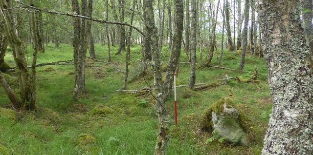
Ladystone Farm submitted by SandyG on 10th Feb 2020. Looking west along the feature. The rubble bank leads away behind the ranging rod (Scale 1m).
(View photo, vote or add a comment)
Log Text: This is a boundary wall and not a stone row.The feature is situated next to The Great Glen Way. Parking is available at NH 63879 44891. From here follow the road uphill to NH 63324 44654 and take the track on your right which joins the Great Glen Way at NH 62634 43756.
Tom Nan Carragh
Date Added: 9th Jan 2019
Site Type: Standing Stones
Country: Scotland (Highlands)
Visited: Yes on 7th Jul 2018. My rating: Condition 3 Ambience 5 Access 3
Tom Nan Carragh submitted by cosmic on 4th Aug 2004. Tom Nan Carragh at NJ011246 in Highland region is a dog leg of three stones. The end stones are not visible form each other due to the lie of the land although all three stones are about seven feet high and about 100m apart. The bearing between the East stone and the middle is about 40 degrees whilst between the middle and West it is nearer 80 degrees.
(View photo, vote or add a comment)
Log Text: Limited car parking is available at NJ 01411 25455. Carefully cross the public highway and walk down the farm road to Lower Graich. Walk past the farm yard and follow the track to Tom nan Carragh.
Gallowhill Wood
Date Added: 10th Jan 2019
Site Type: Stone Row / Alignment
Country: Scotland (Perth and Kinross)
Visited: Yes on 6th Jul 2018. My rating: Condition 2 Ambience 1 Access 4
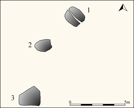
Gallowhill Wood submitted by SandyG on 10th Jan 2019. Plan of Gallowhill Wood stone row showing the position of the numbered stones (Source 1:100 survey by Sandy Gerrard).
(View photo, vote or add a comment)
Log Text: Limited car parking is available nearby at NO 16695 35933. Please ensure that you get permission from the owners of the adjacent house before leaving your car.
Commonbank
Date Added: 10th Jan 2019
Site Type: Stone Row / Alignment
Country: Scotland (Perth and Kinross)
Visited: Yes on 6th Jul 2018. My rating: Condition 2 Ambience 5 Access 3
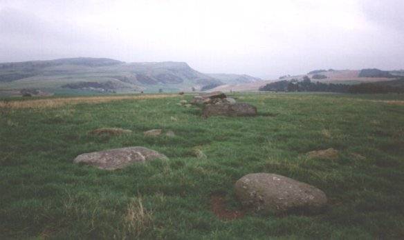
Commonbank submitted by Nick on 5th Nov 2002. Looking to the east over the row. Take the turning into Glencarse from the A90 between Perth and Dundee. Head NNW just after the hotel, and follow signs for Gouktoun. Take a right, then right again for Balthayock, and follow this road for about two miles. The stones lie within the farm lands of Commonbank Farm, lying to the west of the road. They are accessible via the farm road and through the fields, but permission should be sought from the farmer as stock are in the fields. I found the ...
(View photo, vote or add a comment)
Log Text: Car parking is available at Commonbank Farm (NO 17819 24560) but permission should be obtained before parking.
Commonbank
Date Added: 10th Jan 2019
Site Type: Stone Circle
Country: Scotland (Perth and Kinross)
Visited: Yes on 6th Jul 2018. My rating: Condition 1 Ambience 5 Access 3
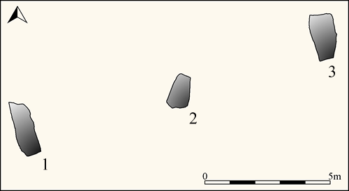
Commonbank submitted by SandyG on 10th Jan 2019. Plan of Commonbank stone row showing the position of the numbered stones (Source: survey by Sandy Gerrard and George Currie at 1:100).
(View photo, vote or add a comment)
Log Text: Car parking is available at Commonbank Farm (NO 17819 24560) but permission should be obtained before parking.
The Shearers
Date Added: 12th Jan 2019
Site Type: Stone Row / Alignment
Country: Scotland (Scottish Borders)
Visited: Yes on 27th Jun 2018. My rating: Condition 3 Ambience 5 Access 3
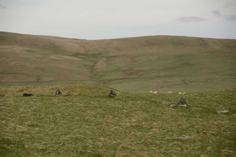
The Shearers submitted by Anne T on 8th May 2015. This was my first view of The Shearers, running across the centre/middle of the photograph from left to right.
(View photo, vote or add a comment)
Log Text: Limited car parking is available in Hownam village at NT 77872 19153. From here follow the track uphill to the east. There is a fine standing stone at NT 78747 18908 which is worth checking out. From here follow the track to NT 79205 19048 then head north. I would like to thank Anne and Andrew Tate for helping with the survey and for sharing such an enjoyable day in another special place.
Threestoneburn
Date Added: 12th Jan 2019
Site Type: Stone Circle
Country: England (Northumberland)
Visited: Yes on 26th Jun 2018. My rating: Condition 3 Ambience 4 Access 1
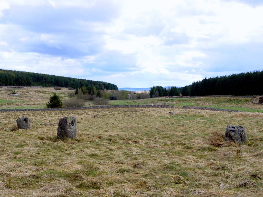
Threestoneburn submitted by Creative Commons on 19th May 2013. Also known as Ilderton Stone Circle. The view here is easterly, with your back to the forest fence, looking back down the valley towards Threestoneburn House.
Some of my friends taken on the long walk here would have said, "OK, it's a stone circle but it's hardly Stonehenge or Calanais, is it?".
No it's not Stonehenge or Calanais; it's a north-east stone circle. We do it differently up here. We put rough stones in a rough circle. Job done. Not for us this hacking great lumps of stone...
(View photo, vote or add a comment)
Log Text: This is not an easy row to get to and some might wonder whether the effort is worth it. Bridleways shown on Ordnance Survey maps do not exist and visiting it on the hottest day of the year is not recommended. Sadly in common with many rows next to forestry you will need to watch out for ticks. The route described below worked for me, but alternatives may exist. Park at NT 96325 23259. Cross the bridge and follow the footpath to NT 96195 22029. From here the best way is to follow the quad bike track on the southern side of the wall. This will take you to the access gate into Threestoneburn Wood at NT 96970 20964. From here follow the forest track to the row and circle.
Whittondean Farm
Date Added: 10th Feb 2020
Site Type: Stone Row / Alignment
Country: England (Northumberland)
Visited: Yes on 24th Jun 2018. My rating: Condition 2 Ambience 4 Access 2
Whittondean Farm submitted by SandyG on 10th Feb 2020. The “stone alignment” scheduled by Historic England forms part of a field boundary or wall. View from west.
(View photo, vote or add a comment)
Log Text: Car parking is available at NZ 05267 98785. From here head north. There is plenty of rock art and some interesting prehistoric field boundaries to see.
Lordenshaw Hillfort
Date Added: 10th Feb 2020
Site Type: Hillfort
Country: England (Northumberland)
Visited: Yes on 24th Jun 2018. My rating: Condition 3 Ambience 4 Access 4
Lordenshaw Hillfort submitted by DrewParsons on 2nd Oct 2011. View of the second of the two entrances. September 2011.
(View photo, vote or add a comment)
Log Text: None
Standingstone Rigg
Date Added: 29th Jan 2019
Site Type: Stone Row / Alignment
Country: England (Northumberland)
Visited: Yes on 23rd Jun 2018. My rating: Condition 2 Ambience 4 Access 2
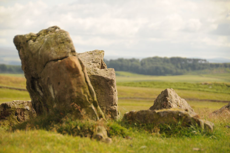
Standingstone Rigg submitted by Anne T on 15th Jul 2014. This photograph is taken from the top of Standingstone Rigg looking south east. The pairing of the stones is identifiable.
(View photo, vote or add a comment)
Log Text: Limited car parking is available at NY 83118 75082. From here follow the track south looking out for the small four-stone circle at NY 82942 74717. Follow the track past Great Lonbrough and onto the access land at NY 81612 73313. From here it is a short walk west to the stones.
There are a number of separate and connected reasons for doubting the prehistoric stone row interpretation of this site:-
In places there seems to be a rubble bank between the upright stones.
At one point near to the sheep fold there is a clear lynchet along the orientation of the feature
At the northern end, the feature descends a very steep slope. No other row is known to do this.
A line of lines at NY 81514 73328 suggests that the feature turns at a right angle and heads east from NY 81499 73317. Severe shifts of alignment such as this are not a characteristic of stone rows but are common in field boundaries
The spacing between the rows is inconsistent
The form of the feature is similar to prehistoric boundary walls
The southern part of the feature is orientated on a pronounced kink in a boundary bank.
On the basis of the available evidence it would therefore appear unlikely that this feature represents the remains of a prehistoric stone row and instead is more likely to be the partly robbed remains of a field boundary, probably of prehistoric date because historic boundaries in the vicinity appear to be of the ditch and bank type.
