Contributory members are able to log private notes and comments about each site
Sites Ermine has logged. View this log as a table or view the most recent logs from everyone
Grime's Graves Flint Mines
Trip No.10 Entry No.4 Date Added: 12th Apr 2017
Site Type: Ancient Mine, Quarry or other Industry
Country: England (Norfolk)
Visited: Yes on 6th Apr 2017. My rating: Condition 3 Ambience 4 Access 4

Grime's Graves Flint Mines submitted by ermine on 7th Apr 2017. Antler picks, Greenwell Pit, Grimes Graves
(View photo, vote or add a comment)
Log Text: It's worth bearing in mind that to see much underground you will need to enter the shaft on hands and knees, so dress accordingly. The temperature is about 10C.
The flint was mined from the chalk using red deer antlers that had been naturally shed - the antler material is hardest when just shed.
There are two other pits which have been entered by the public on the site - one which is now closed was the one open to the public in the 1960s and 70s, and the current public access pit, Pit One.
(part 4 of 4)
Grime's Graves Flint Mines
Trip No.10 Entry No.3 Date Added: 12th Apr 2017
Site Type: Ancient Mine, Quarry or other Industry
Country: England (Norfolk)
Visited: Yes on 6th Apr 2017. My rating: Condition 3 Ambience 4 Access 4
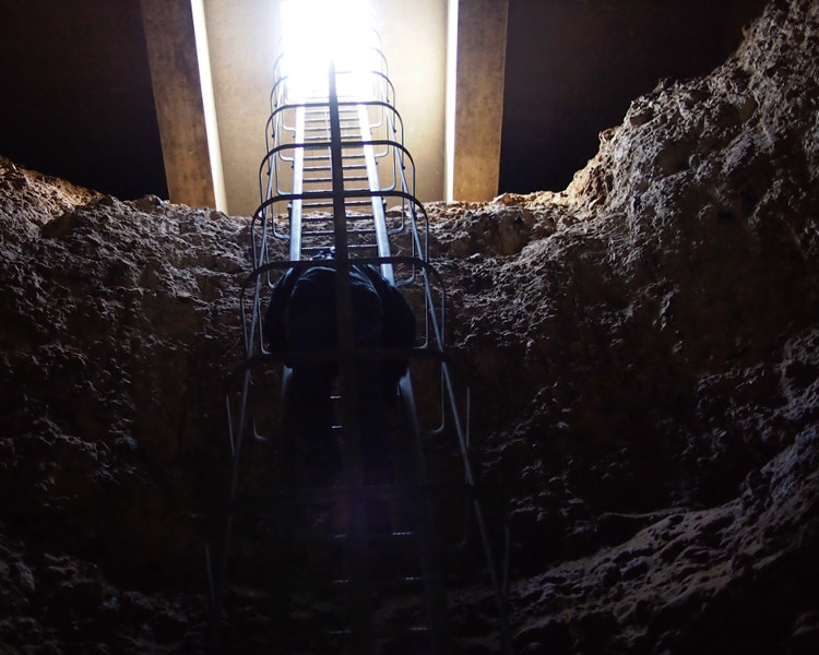
Grime's Graves Flint Mines submitted by ermine on 7th Apr 2017. Descent into Greenwell Pit - ladder
(View photo, vote or add a comment)
Log Text: Unlike the public access pit this one will generally be via restricted ticketing, the event I was at was a members event. The English Heritage description of the event
thanks to a new winch and harness system we can now access Greenwell’s Pit and see a mining shaft in its original archaeological state.
Join our Neolithic expert Will Lord and discover the history and archaeology of the site before he leads the descent in to the newly opened pit.
This event has been graded as challenging access as the descent in to the pit is by winch and harness only and will require an extended period underground.
made it sound like we were going to abseil into the pit, but although visitors are kitted up with a harness and attached to a winch with a breakaway cable, this is only a safety requirement in case someone slips or has a heart attack underground, entry is quite conventional, down a steel ladder.
(part 3 of 4)
Grime's Graves Flint Mines
Trip No.10 Entry No.2 Date Added: 12th Apr 2017
Site Type: Ancient Mine, Quarry or other Industry
Country: England (Norfolk)
Visited: Yes on 6th Apr 2017. My rating: Condition 3 Ambience 4 Access 4

Grime's Graves Flint Mines submitted by ermine on 7th Apr 2017. Grazing sheep used to keep the English Heritage site of Grimes Graves clear of trees and brushwood
(View photo, vote or add a comment)
Log Text: There’s not much to see above ground at Grimes Graves, this is a mine, after all, so all the action happened underground. The surface is pockmarked by depressions where the backfill has settled, and sheep are used to keep the ground clear.
(part 2 of 4)
Grime's Graves Flint Mines
Trip No.10 Entry No.1 Date Added: 12th Apr 2017
Site Type: Ancient Mine, Quarry or other Industry
Country: England (Norfolk)
Visited: Yes on 6th Apr 2017. My rating: Condition 3 Ambience 4 Access 4

Grime's Graves Flint Mines submitted by ermine on 7th Apr 2017. One of the radial shafts at Grimes, Graves, Greenwell Pit. Originally the floor would have been covered in flint
(View photo, vote or add a comment)
Log Text: English Heritage have opened up a new pit to occasional public access. Greenwell Pit is one of the 433 on the Grimes Graves neolithic flint mine site at Grimes Graves. I was on the first public descent into this pit – it had of course been opened and entered before by archaeologists, but the 6th April was the first time it had been opened to the public.
(part 1 of 4)
Kerlescan Alignements
Date Added: 22nd Jun 2016
Site Type: Multiple Stone Rows / Avenue
Country: France (Bretagne:Morbihan (56))
Visited: Yes on 10th Sep 2002

Kerlescan alignements submitted by ermine on 10th Sep 2002. View of the Kerlescan alignments at Carnac.
The alignments are formed of rows of standing stones running for several hundred yards approximately E/W Panorama is taken from the NW
(View photo, vote or add a comment)
Log Text: None
Ménec alignements
Date Added: 22nd Jun 2016
Site Type: Multiple Stone Rows / Avenue
Country: France (Bretagne:Morbihan (56))
Visited: Yes on 10th Sep 2002

Ménec alignements submitted by ermine on 10th Sep 2002. View of the Carnac Alignments from Le Menec village at the western end. The alignments consist of up to twelve rows of menhirs extending for almost a kilometre
(View photo, vote or add a comment)
Log Text: None
Clendy Steinalleen
Date Added: 22nd Jun 2016
Site Type: Stone Row / Alignment
Country: Switzerland (Waadt)
Visited: Yes on 23rd Jun 2004
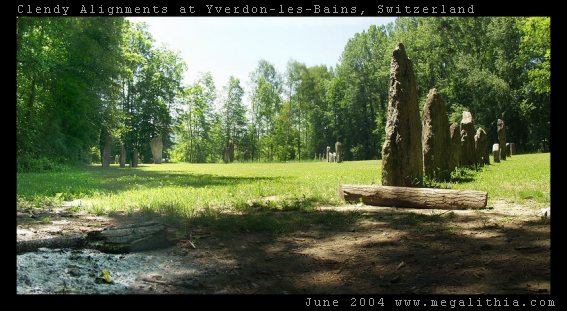
Clendy Steinalleen submitted by ermine on 23rd Jun 2004. Alignment of standing stones at the southern end of Lac Neuchatel, Switzerland near Yverdon-Les_Bains. Two lines of standing stones intersect, roughly at the camera POV. As well as the straight lines, there is a semicircle of stones. For more details see http://www.megalithia.com/sites/4678n0666e.html
(View photo, vote or add a comment)
Log Text: None
Grandson Menhir
Date Added: 22nd Jun 2016
Site Type: Standing Stone (Menhir)
Country: Switzerland (Waadt)
Visited: Yes on 27th Jun 2004
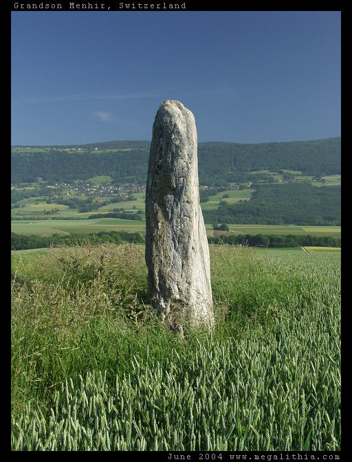
Grandson Menhir submitted by ermine on 27th Jun 2004. Grandson Menhir
See megalith map entry
(View photo, vote or add a comment)
Log Text: None
Kerran Dolmens
Date Added: 22nd Jun 2016
Site Type: Chambered Tomb
Country: France (Bretagne:Morbihan (56))
Visited: Yes on 27th Jun 2004

Kerran dolmens submitted by ermine on 27th Jun 2004. Kerran
47.598N 2.988W
This is one of two dolmens near the intersection of the D28 with the D781 (the other is more dilapidated)
(View photo, vote or add a comment)
Log Text: None
Pierres Plates (Locmariaquer)
Date Added: 22nd Jun 2016
Site Type: Burial Chamber or Dolmen
Country: France (Bretagne:Morbihan (56))
Visited: Yes on 27th Jun 2004
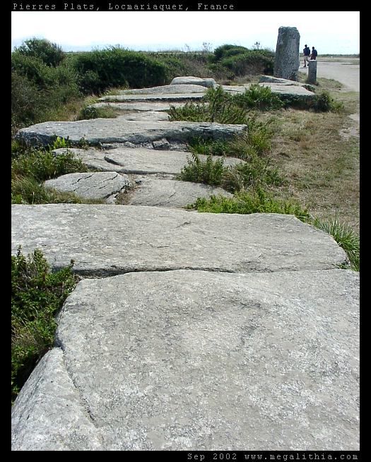
Pierres Plates (Locmariaquer) submitted by ermine on 27th Jun 2004. Les Pierres Plates
(View photo, vote or add a comment)
Log Text: None
La Table des Marchands
Date Added: 22nd Jun 2016
Site Type: Burial Chamber or Dolmen
Country: France (Bretagne:Morbihan (56))
Visited: Yes on 27th Jun 2004

La Table des Marchands submitted by ermine on 27th Jun 2004. Table des Marchands - carving in capstone
(View photo, vote or add a comment)
Log Text: None
Luffang Allée Couverte
Date Added: 22nd Jun 2016
Site Type: Passage Grave
Country: France (Bretagne:Morbihan (56))
Visited: Yes on 27th Jun 2004

Luffang Allée Couverte submitted by ermine on 27th Jun 2004. 47.61309N 3.024552W
This passage-grave contained unique artwork on the end stone, now preserved in Carnac museum. Signposted at the site as Allee Couverte
(View photo, vote or add a comment)
Log Text: None
Grand Menhir Brisé
Date Added: 22nd Jun 2016
Site Type: Standing Stone (Menhir)
Country: France (Bretagne:Morbihan (56))
Visited: Yes on 27th Jun 2004
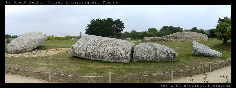
Grand Menhir Brisé submitted by ermine on 27th Jun 2004. Grand Menhir Brisé, Locmariaquer.
A megalithic tragedy.
(View photo, vote or add a comment)
Log Text: None
Degernau Menhir
Date Added: 22nd Jun 2016
Site Type: Standing Stone (Menhir)
Country: Germany (Baden-Wuerttemberg)
Visited: Yes on 27th Jun 2004
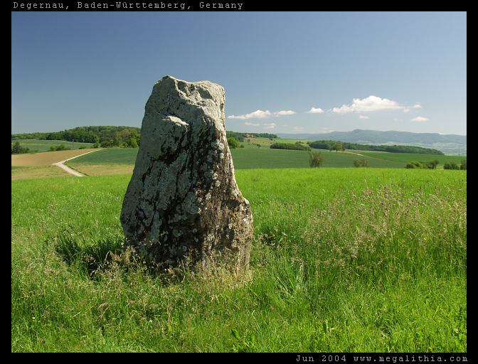
Degernau Menhir submitted by ermine on 27th Jun 2004. Menhir of Degernau, Baden-Württemberg, Germany
47.66380N 8.401683E
lovely setting on the crest of a rise with a commanding view
(View photo, vote or add a comment)
Log Text: None
Martlesham Heath
Date Added: 22nd Jun 2016
Site Type: Round Barrow(s)
Country: England (Suffolk)
Visited: Yes on 29th Jun 2004

Martlesham Heath submitted by ermine on 29th Jun 2004. Grid Reference: TM256454
Type of site: Round Barrow
County : Suffolk
Nearest Town: Ipswich
Nearest Village: Martlesham Heath
Any web links relating to it: <a target=_top href="http://www.megalithia.com/sites/tm256454.html">Megalithia</a>
Barrow hidden in the woods on the left-hand side of the footpath leading from the industrial estate past the trailer park, as you come out of the woods and see the BT Earth station dishes to your right. A possible smaller site is ab...
(View photo, vote or add a comment)
Log Text: None
Mané Keriaval
Date Added: 22nd Jun 2016
Site Type: Passage Grave
Country: France (Bretagne:Morbihan (56))
Visited: Yes on 30th Jun 2004
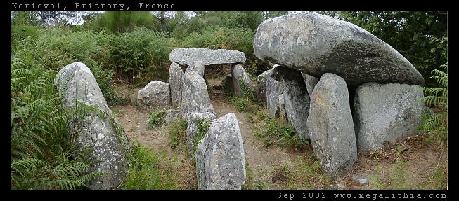
Mané Keriaval submitted by ermine on 30th Jun 2004. Morbihan, Carnac area
47.61535N 3.083378W WGS84 GPS onsite
You'd be forgiven for thinking this is a dolmen, and it is locally listed as such, but Burl sets you right. These stones were originally a passage grave with an earth mound on top
(View photo, vote or add a comment)
Log Text: None
Kerzerho Alignements
Date Added: 22nd Jun 2016
Site Type: Multiple Stone Rows / Avenue
Country: France (Bretagne:Morbihan (56))
Visited: Yes on 1st Jul 2004
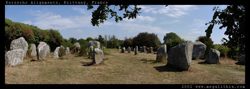
Kerzerho Alignements submitted by ermine on 1st Jul 2004. Kerzerho Alignments
Brittany, Morbihan
47.634690N 3.148402W GPS onsite
You can still walk among the stones at Kerzerho (in 2002 at east) which are near Carnac but not quite so busy. Head up the D781 to Erdeven. You can park nearby, and from there you can also take the path to the large stones of the Table du Sacrifice
(View photo, vote or add a comment)
Log Text: None
Kerloas Menhir
Date Added: 22nd Jun 2016
Site Type: Standing Stone (Menhir)
Country: France (Bretagne:Finistère (29))
Visited: Yes on 14th Jul 2004
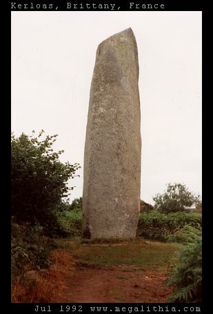
Kerloas menhir submitted by ermine on 14th Jul 2004. This is the tallest standing stone in Europe, according to Aubrey Burl, and would be even taller had it not been hit by lightning 200 years ago. It stands today at 9.5 m above ground.
(View photo, vote or add a comment)
Log Text: None
Le Petit Ménec
Date Added: 22nd Jun 2016
Site Type: Multiple Stone Rows / Avenue
Country: France (Bretagne:Morbihan (56))
Visited: Yes on 6th Aug 2004
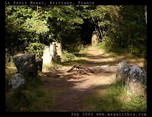
Le Petit Ménec submitted by ermine on 6th Aug 2004. Confusingly, Petit-Menéc is in fact at the opposite, eastern end of the alignments to le Menéc village at the western end. You need to turn left onto the D186 main road after continuing from Kerlescan. After about 250m turn right into a minor road going past a forest, there is a clearing where you can park after about 400m. The menhirs are in the forest on your right, arranged in a gentle curve. You don't get the same clear overview of the alignments since the view is obscured by the trees, bu...
(View photo, vote or add a comment)
Log Text: None
Menhir de Goulvars
Date Added: 22nd Jun 2016
Site Type: Standing Stone (Menhir)
Country: France (Bretagne:Morbihan (56))
Visited: Yes on 8th Aug 2004

Menhir de Goulvars submitted by ermine on 8th Aug 2004. This 4m tall granite menhir stands near the Conguel campsite and the Quiberon aerodrome - it extends another 1m into the ground, according to the information board
(View photo, vote or add a comment)
Log Text: None
